
Seasonality
Summary
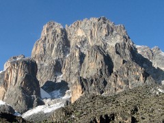
Mount Kenya is the second highest mountain on the African continent and provides extensive opportunities for multi-pitch rock climbing, mountaineering and, increasingly infrequently, ice climbing.
©Description
Slab
Vertical
Wet in rain
Windy
Mt Kenya’s peaks are formed from the hard core or plug of a volcano, the crater having long since been eroded away, and rises steeply on all sides some 450 m above the glaciers and scree slopes. There is excellent rock and ice climbing of a high standard to the twin summit peaks of Batian (5,199 m) and Nelion (5,188 m). The third highest peak is Pt. Lenana (4,985 m) which can be reached by any fit walker, suitably equipped and there is plenty of excellent ridge walking and scrambling up to heights of over 4,600 m.
Mt Kenya is in condition for rock climbing during two drier seasons, although those have not been well defined in recent years. From late December to March, the south faces of Mt Kenya are in the sun, while from June to October the north side is in the sun. The best season for routes with other orientations (e.g. east or west) is usually specified in their descriptions.
Despite its size, it is possible to gain altitude rapidly on Mt. Kenya and overzealous climbers run the risk of high-altitude sickness. Mt. Kenya is responsible for a large proportion of the world’s high-altitude pulmonary oedema cases (a potentially fatal form of Acute Mountain Sickness). This can be prevented (and the experience made more enjoyable) if a sensibly slow approach is made.
Also, because Mount Kenya is so close to the equator, night can descend with surprising rapidity, only about half an hour after the sun has set, which can catch out visitors from further latitudes.
Mount Kenya, like most mountains, can be a very dangerous place. Many people are injured and even killed each year. Do not attempt the mountain if you suffer from any health problems, or if you do not have the appropriate gear.
The elevation range is approximately 2,200 m to 5,200 m and includes several distinct vegetation zones: Mixed broad-leaf forest, Gallery Forest, Bamboo, Giant Heath and Hagenia, moorland tussock grasses, Giant Senecio and Lobelia and, at the uppermost elevation, rock and ice.
In 1997 UNESCO inscribed Mount Kenya a World Heritage Site as “one of the most impressive landscapes in Eastern Africa with its rugged glacier-clad summits, Afro-alpine moorlands and diverse forests that illustrate outstanding ecological processes”. Since 1978, the area is also an International Biosphere Reserve. Mt. Kenya, an extinct volcano that last erupted between 2.8 to 3.2 million years ago, was gazetted a National Park in 1949 and a National Reserve in 2000 and is managed by Kenya Wildlife Service (KWS).
©Access issues
Paid
Mt Kenya is located within the Mt Kenya National Park and managed by the Kenya Wildlife Service (KWS) - entry fees and other info are available here - http://www.kws.org/tourism/tariffs.html
KWS regulations require all visitors to register upon entrance to the mountain and sign out on departure. Hiking alone is prohibited so you need a buddy or a guide. No burning is allowed. Take all litter out with you.
©Approach
Steep hike
3+ hour
To the Park - Mt. Kenya lies some 200 km north of Nairobi. Good roads lead to the nearby towns of Naro Moru (west side), Chogoria (east side) and Nanyuki (north side). From these locations, roads and tracks (approx. 20-30 km in length) lead up to the three main roadheads and the park gates. Some of these are often in very poor condition, necessitating a 4-wheel drive vehicle, or walking. The roads to Met Station from the Naro Moru Gate and to Old Moses from the Sirimon Gate are passable without a 4wd vehicle.
Car hire in Nairobi is readily available or one can take public buses (matatus) from Nairobi for around Ksh 700 - although those are not the safest form of transport they can get you to the turnoff from the main road. Then, to get to the roadheads one has to walk or get one of the motorbike taxis that are usually found near the Sirimon turnoff from the main road, or at Naro Moru.
Entry to and exit from the Mt. Kenya National Park can only be made during daylight hours before 6pm. The forest zone can be dangerous due to buffalo and elephant, especially at night. Although the higher huts on the mountain (above 4,000m) can be reached in one day from the road, its strongly recommended that two days be taken unless you are already acclimatised.
On the mountain - The Naro Moru, Chogoria and Sirimon Routes are by far the most popular routes up the mountain. Other routes (Timau, Burguret, Kamweti and Meru) have existed in the past, but have now fallen into differing states of disrepair and considerable navigation skill and physical strength and stamina are now required to attempt them, as well as a permit from the Park Headquarters. There are some tour operators offering guiding on these routes.
Timings given should be adequate for moderately fit parties not too heavily laden, with allowance only for brief halts. A good reserve should always be allowed for, and a start should be made early in the morning. For the descent allow at least half the time taken on the ascent.
NARO MORU ROUTE This route to the Teleki Valley is the shortest way to the peaks and is one of the most popular tracks. Owing to the fact that it is the shortest way up the mountain, there is a tendency for visitors to ascend too quickly and become the victims of mountain sickness and other illnesses related to altitude. It is therefore strongly advised that visitors unaccustomed to high altitude should consider hiking the first day from the Park Gate to the Met Station, rather than driving this stage of the ascent.
From Naro Moru town a well signposted mostly paved road leads 17 km to the Park entrance (2,400 m). If driving from Nairobi one can also follow the signposts for Naro Moru gate around 10 km before Naro Moru town, following a good paved road which then joins up with the road from Naro Moru town itself. After the Park entrance a paved road leads to the Met Station trailhead at 3,050 m where cars can be parked. A concrete walking track then climbs more steeply passing the MET station and then narrows to a footpath leading to the edge of the forest.
A steep, marshy section known as the “vertical bog” follows. The route keeps to the south side of the ridge, through open moorland until (about 3½ to 4 hours from the Met Station) the path reaches the crest of the ridge overlooking the Teleki Valley (4,000 m). The path contours along the south side of the Teleki Valley, keeping first high, and then gradually descends to reach the valley floor. It then follows the valley to reach Mackinder's Camp (4,200 m) with spectacular views of the south side of the mountain. From the Met Station to this point is about five to six hours.
The Austrian Hut (4,790 m) can be reached in a further three or four hours, but it is advisable not to attempt this from the Met Station in one day. The path to Austrian Hut (and onwards to Pt Lenana) leads from Mackinder’s Camp and initially contours up the left-hand side of Teleki Valley. A long pull then leads up the lateral moraine of the Lewis Glacier, veering left to the rocky bluff where the Austrian Hut is situated. Austrian Hut was the common starting point for those attempting the South-East Face of Nelion but it is also possible to access the route from Mackinder’s camp in about 3 hours
The KWS Rescue Ranger Station is located near the head of the Teleki Valley and close to the Mountain Club of Kenya hut.
SIRIMON ROUTE This track provides the easiest access to the northern side of the central peaks and the North Face Standard Route on Batian. It is a beautiful route with fine views of Sendeo and Terere, and of the main peaks. About 15 km from Nanyuki on the Timau road, just before the road winds down to cross the Sirimon River, a signposted track to the right leads 10 km to the Park Gate.
A paved road from the gate leads to Old Moses Hut and Judmaier Camp at the roadhead at 3,350 m. The track climbs 300m up the hill behind the hut to a communications station. Just beyond this point the track splits with the left hand route proceeding to the Mackinder Valley direct, and the right hand route going via the Liki North Hut.
The direct route contours the moorland across a series of ridges, dropping down to cross the Liki North River (where there is a bridge and picnic site) and then climbing the ridge to enter the Mackinder Valley. The path continues up the valley to the cliffs beneath Shipton’s Cave. From here the path climbs steeply up to the right and continues to Shipton’s Camp hut (4,250 m). From Old Moses to this point is about 6-7 hours.
The route via Liki North hut is tougher (8-9 hours to Shipton’s Camp). From the split head uphill towards a rounded hill called the Barrow. The path swings south climbing to the ridge of the Liki North Valley and then drops to the Liki North Hut (3,990m). The hut no longer exists but there is a campsite and this is a popular starting point for climbs on Sendeo and Terere. From the Likii North Hut the path climbs the ridge and then descends into the Mackinder Valley to join the direct route.
From Shipton’s Camp two main paths continue. To the right of the main peaks the path climbs to the Hausberg Col via Kami Tarn (which lies close to the start of the North Face Standard route. To the left the path ascends to Harris Tarn from which Pt Lenana can be reached.
CHOGORIA ROUTE The Chogoria route is considered the most picturesque on the mountain. It has no huts and requires climbers and hikers to be self-sufficient for camping.
The route begins from Chogoria town to the east of the mountain, about 96 km from Embu and 64 km from Meru. From here a 4 wheel drive vehicle is necessary to drive the 29 km track to the Park Gate at 3,000 m. There is accommodation available here at the Meru Mt Kenya Bandas. From the gate, the track continues to the Chogoria roadhead. From here the path tracks the north side of the Gorges Valley to reach Hall Tarns (4,230m) sitting on a plateau above Lake Michaelson. To reach Hall Tarns takes between 6 and 9 hours from the Chogoria Gate.
The path from Hall Tarns eventually splits. The right-hand path continues to Simba Col (4,620m) from where you can descend to Shipton’s Camp and the Mackinder Valley or continue up the ridge to Harris Tarn and then to Pt Lenana. The left-hand path takes you steeply up to Tooth Col and round Pt Lenana to the south to reach Austrian Hut.
©Where to stay
There are a number of accommodation options outside the Mt Kenya National Park in the nearby towns of Nanyuki, Naro Moru and Chogoria. It is possible to camp or stay in bandas at the park gates. Please enquire directly with the operators of the accomodation for the latest fees. The fees below were accurate as of February 2019.
Accommodation on the mountain depends on the route hiked and there is a mixture of huts and campsites along each route. A tent is useful (or essential on the Chogoria Route or less well-travelled routes). Otherwise, the mountain has several huts, though it should be noted that several huts listed in old guidebooks have been demolished. Most of the existing huts are privately owned. If you plan to stay in huts, please contact the appropriate organisations for bookings. The fees help maintain the huts.
PARTIES USING THESE HUTS SHOULD LEAVE THEM CLEAN AND TIDY, AND BRING ALL GARBAGE OFF THE MOUNTAIN. PLEASE DO NOT MAKE USE OF OLD RUBBISH DUMPS.
NARO MORU ROUTE · Naro Moru River Lodge, 1.5 km from the main road in Naro Moru town, is a popular starting point with bunkhouse and guesthouse accommodation. · Met Station (3,050m) has basic self-service accommodation and camping at the roadhead of the Naro Moru route as is accessible on a paved road. The fees per person per night at Met Station for Kenyan citizens and residents are 1500 Ksh in low season (1 March-30 June and 16 September-8 December) Ksh , and 1900 Ksh in high season (all other times). For non-residents the rates are 26 USD for high season and 21 USD for low season. · Mackinder’s Camp (4,200m) in the Teleki Valley has a hut accommodating 66 people. The fees per person per night for Kenyan citizens and residents are 2000 Ksh for low season and 2600 Ksh for high season (same dates as above). The rates for non-residents are 27 USD for low season and 36 USD for high season.
Both Met Station and Mackinder’s Camp are owned by Naro Moru River Lodge. Fees are payable at a booking agent, the park/reserve gates, or online: http://naromoruriverlodge.com/ . Mountain Club of Kenya (MCK) members pay discounted rates when booked direct with the lodge.
· Austrian Hut (4,790 m) has three rooms and sleeps 30 people. It was opened in February 1973. Austrian Hut is manned by Kenya Wildlife Service staff, and costs 2000 KSh per night (same price for residents and non-residents). Payment can ONLY be made at the park/reserve gates for which a receipt MUST be obtained. Unplanned or additional nights at Austrian Hut are possible but payment for this is made at the park gate on exit against a receipt and NOT direct to the staff manning the hut.
SIRIMON ROUTE · Old Moses Hut (3,350 m) at the Sirimon Route roadhead offers self-service accommodation and costs 2500 Ksh per person per night (same price for residents and non-residents). · Shipton’s Camp (4,250 m) in the Mackinder Valley sleeps 40 people. It costs 3000 Ksh per person per night (same price for residents and non-residents).
Both huts are owned by Mountain Rock. MCK members pay discounted rates when booked direct at the lodge. Both of these can be reserved in Nairobi, at the Mountain Rock Hotel in Nanyuki, or online: https://www.mountainrockkenya.com/bantulodge/contact.php
· Liki North (3,993 m) no longer has a hut but there is a campsite.
CHOGORIA ROUTE The Chogoria Route is only for parties equipped for camping. Tents must be shown at the Chogoria Park Gate before parties can enter. · Meru Mt. Kenya Lodge at the Chogoria Gate costs US $15 per person. · Minto's Hut (4,297 m) is by Hall Tarns. The hut is for use by porters only.
ON NELION Howell Hut (5,188 m) - This magnificent bivouac shelter is located on the summit of Nelion. It was built by Ian Howell in February 1970 after five loads of construction materials had been successfully parachuted onto the Lewis Glacier. In a feat which can only be described as remarkable, Howell then made thirteen solo ascents of Nelion as he gradually carried the materials to the summit. The floor is foam covered. Baillie’s Bivy is about half-way to the top of Nelion but it has fallen into disrepair, often filled with snow and ice. Few people stay there nowadays.
©Ethic inherited from Kenya
If you want to open new climbs in Kenya, kindly contact the Mountain Club of Kenya (www.mck.or.ke). We'll be happy to help!
Here is our bolting policy, please abide by it: http://mountainclubkenya.org/wp-content/uploads/2017/03/Bolting-Policy.pdf
©Tags
Plan your Trip
Some content has been provided under license from: © Mountain Club of Kenya (Copyright Mountain Club of Kenya)
Hello!
First time here?
theCrag.com is a free guide for rock climbing areas all over the world, collaboratively edited by keen rock climbers, boulderers and other nice folks.You can log all your routes, connect and chat with other climbers and much more...» go exploring, » learn more or » ask us a question


Accommodations nearby more Hide
Share this
Photos Browse all photos

Point Melhuish - Frozen Rainbow Pitch 3 (crux)

Point Melhuish - Frozen Rainbow pitch 1
/b7/4c/b74c7eea765925fe1c06cb1a798f0eed60a23092)
Point Melhuish - Frozen Rainbow Pitch 2 (top of)
Fri 2 Jun
Check out what is happening in Mt Kenya.
Get a detailed insight with a timeline showing
- Ticks by climbers like you
- Discussions of the community
- Updates to the index by our users
- and many more things.
Login to see the timeline!