A Crag Guide gives an extensive view of all sub areas and climbs at a point in the index. It shows a snapshot of the index heirachy, up to 300 climbs (or areas) on a single web page. It shows selected comments climbers have made on a recently submitted ascent.
At a minor crag level this should be suitable for printing and taking with you on a climbing trip as an adjunct to your guidebook.
This guide was generated anonymously. Login to show your logged ascents against each route.
Warning
Rock climbing is extremely dangerous and can result in serious injury or death. Users acting on any information directly or indirectly available from this site do so at their own risk.
This guide is compiled from a community of users and is presented without verification that the information is accurate or complete and is subject to system errors. By using this guide you acknowledge that the material described in this document is extremely dangerous, and that the content may be misleading or wrong. In particular there may be misdescriptions of routes, incorrectly drawn topo lines, incorrect difficulty ratings or incorrect or missing protection ratings. This includes both errors from the content and system errors.
Nobody has checked this particlular guide so you cannot rely on it's accuracy like you would a store bought guide.
You should not depend on any information gleaned from this guide for your personal safety.
You must keep this warning with the guide. For more information refer to our:
Usage policy
Contributors
Thanks to the following people who have contributed to this crag guide:
Matt Battani
Pierre Gay Perret
Sébastien Milleville
Benoit Fabre
Brendan Heywood
Jokep
Emmanuel F
Laura Schmucker
Astrid Hedman
Mountain Club of Kenya
The size of a person's name reflects their Crag Karma, which is their level of contribution. You can help contribute to your local crag by adding descriptions, photos, topos and more.
Some content has been provided under license from: © Matt Battani (Matt Battani)
Table of contents
- 1.
Uganda / UG
143 in Area
-
1.1.
MCU Muyenga Quarry / Clarke University Quarry / Pierre's Quarry 27 in Crag
- 1.1.1. Right Hand Wall 27 in Sector
- 1.1.2. Left Hand Wall 0 in Unknown
-
1.2.
Bukasa quarry / MCU Second quarry of MCU 12 in Area
- 1.2.1. the capitan of Bukasa / Bukasa main quarry 12 in Area
- 1.2.2. Beginner wall 0 in Area
- 1.3. International School of Uganda / ISU/ Lubowa 0 in Artificial
-
1.4.
Nsiita / Luwazi 24 in Area
- 1.4.1. Elie's Boulder 4 in Boulder
- 1.4.2. Nsiita's Right Hand Wall 5 in Sector
- 1.4.3. Nsiita's Main Wall 6 in Sector
- 1.4.4. Nsiita's Corner 3 in Sector
- 1.4.5. Nsiita's Left Hand Wall 6 in Sector
- 1.5. Ketabya 0 in Crag
- 1.6. Nakwero Rock / Kasaayi Rock 0 in Crag
-
1.7.
Kkungu Rock / Kungu 15 in Area
- 1.7.1. Main Inselberg 12 in Sector
- 1.7.2. Secondary Slab 3 in Sector
- 1.8. Kyungu / Namilyango 0 in Crag
- 1.9. Nakasongola 0 in Area
- 1.10. Mubende 0 in Area
- 1.11. Rwakobo Rock / Top of the Rock / Lake Mburo 9 in Crag
- 1.12. Kilembe 11 in Crag
- 1.13. Tororo Rock 0 in Area
-
1.14.
Roco Cave of Tororo Rock 0 in Crag
- 1.14.1. Roco Cave 0 in Crag
- 1.15. Buteba Hill 3 in Boulder
- 1.16. Nagongera I 0 in Boulder
- 1.17. Nagongera II 2 in Boulder
- 1.18. Fang Fang 1 in Crag
- 1.19. Sipi Main Wall 15 in Crag
- 1.20. Chema 7 in Crag
- 1.21. Mary's Rock 1 in Crag
- 1.22. Alekilek 0 in Crag
- 1.23. Moroto / Mt. Moroto 0 in Area
- 1.24. Kenny's Rock 2 in Crag
- 1.25. Amiel 1 in Crag
- 1.26. Mt. Oret / Kalongo 3 in Area
- 1.27. Paimol Rock 0 in Crag
- 1.28. Akwang 0 in Area
- 1.29. Kilibi / Shard 2 in Area
- 1.30. Rwot 2 in Area
- 1.31. Loyoroit / Anopheles 1 in Crag
- 1.32. Naita Rock 1 in Crag
-
1.33.
Patiko 3 in Crag
- 1.33.1. Patiko's Main Wall 3 in Sector
- 1.34. Mt. Wati / Burua Rock 1 in Area
- 1.35. Cha's Lagoon 0 in Sector
-
1.1.
MCU Muyenga Quarry / Clarke University Quarry / Pierre's Quarry 27 in Crag
- 2. Index by grade
1. Uganda 143 routes in Area
- Summary:
-
Sport climbing, Top roping and other styles
Lat / Long: 1.267187, 32.356613
- Costs and Proceeds of this Book
- I have kept costs to a bare minimum and bore those myself. All content will be freely given. The price for printed versions will only cover printing costs. The online content available at theCrag.com and ViewRanger has been made available at no cost.
Everyone might say they are a “guide”. It can be really hard to tell who knows what they are doing and who does not. Use a reputable local contact to help you find a guide whenever possible. I frequently pull into local schools or monasteries. Ask for the father or headmaster. Explain your plans and ask for their help. This usually works. Then, test your guide with some non-leading questions and test their English before agreeing to anything. If there isn’t a school or monastery in sight, then drive as close as possible to the mountain or crag, just start walking in and find a guide along the way. I have found some of my best guides like this, as the people you run into on the path are very local and usually living or studying very nearby. Avoid trying to hire a guide in town centers. It can create quite a commotion and attract the wrong sort of people. Idle and available guides, often consuming alcohol at all times of the day are to be avoided for obvious reasons. Best to pick someone out in their field early “digging” or otherwise occupied. The payment they are likely to get from you is enough to motivate them to put other projects on hold for a day.
Be very clear with your guide. Make sure to explain exactly what you plan to do and what you need the guide to help with. Agree on a set price beforehand. Do not pay in full until the trip is completed. In fact, try to hold back 50-100% of the payment until you are packed, finished and leaving. Paying for any services in full in Uganda ahead of time is often a bad idea. After paying in full, some guides may just run off. Also be aware that these guides may try to cut your trip short and still expect full payment. Even UWA guides have tried this with me. My guide on Kadam swore that terrible weather was coming and that we needed to turn around. My guide on Morungole tried to convince us that the peak was too far and that we couldn’t make it. Long story short, be skeptical of this sort of thing and make sure you know what you are doing. Cutting your trip short will save them time and effort. Of course, they will expect full payment in all cases, regardless of how far you’ve made it.
Set clear rules with your guides. Quite often guides will take any “down payment” and buy waragi, a locally made gin. Sometimes they will chew a mild narcotic called kat as it can be found on some of the mountains. You may have to be quite vigilant with your guides to make sure they don’t end up drunk and/or mildly high. Also, it regularly happens that guides and porters will open your bags and go through your things on these hikes. Perhaps set a clear rule for them to leave your bags closed. It has happened to me on several occasions that guides/porters will consume some of the food/water in the pack they are carrying without asking permission. As frustrating as this might be for you, they don’t consider this inappropriate. Keep all your key valuables with you in your own pack. Remember outside UWA parks these “guides” lack the training and supervision of the somewhat more professional guiding services available inside parks.
Plan on “taking care” of your guides. Most of the people you’ll find in these villages have very few possessions. So, plan on taking some food and water for them. They will not want to eat most things that you do, so get them some local food or ask them to bring their own. They will also not carry water, so plan for that. They usually drink about half as much as me. Finally, if your trip is overnight, you will need to carry everything your guide will need, so tent, sleeping bag, plate, cup, etc. Groups sometimes forget this and end up uncomfortably sharing food, utensils, tents, etc with their guides, or worse they have them sleep outside or send them down in the dark.
summary
Most of UGs great rocks have never been climbed, so FAs abound! There is growing community and some good sport climbing too! It's a gorgeous country and a cheap destination for a climbing holiday.
description
Disclaimer
Uganda is an extremely diverse country. Annoyances and inconveniences may vary from region to region and village to village. What is agreed upon, accepted, or paid in one place may be rejected in another. What is safe one year or in one area may not be safe the next year or in a different region. Uganda, especially some areas, is also extremely remote. Some routes have only been climbed once. With so few climbers it has been impossible to fact check all route descriptions and difficulty grades. It is therefore possible that errors in route descriptions exist. Users of this guide must use their own judgment at all times. Neither the author, nor the publisher accepts any responsibility or liability for accidents or incidents that arise from consulting this book. This guide is intended for experienced climbers only. Climbing and mountaineering are inherently dangerous activities and one could be seriously injured or even killed. Inexperienced climbers should be discouraged from attempting the routes described in this book. Instead, inexperienced climbers should seek advice, help, and training from certified professionals.
Climbing and Mountaineering in Uganda
Uganda has arguably the best mountains in Africa. Tanzania claims the highest mountain (Kilimanjaro) and Kenya #2 (Mt. Kenya), but Uganda has huge mountains that are unspoiled, unique, remote, and see far fewer visitors. The incredible Rwenzori (third highest in Africa), are a true mountain range, soar over 5100m and contain glaciers on the equator! The virungas in the southwest have pristine trails, gorgeous jungles, rare mountain gorillas, and postcard quality bamboo zones. The peaks of Moroto, Kadam, Rom, Zulia, Napak and Morungole in Karamoja are almost completely unknown to the outside world and choke full of “raw” Uganda.
Uganda never had large numbers of European colonists or settlers like some regions of Africa. By comparison to Kenya, South Africa and Namibia, parts of Uganda have had very little European influence, hence there has been less climbing and less mountain exploration here. As I traveled around the country climbing, hiking, kayaking and looking for other adventures, I found climbable rocks and mountains mostly around the borders of the country. The British, under which Uganda was held as a protectorate until 1962, drew up the borders of the country using natural, geographic borders (mostly mountains), so following the land borders makes sense for climbers and mountaineers. In the west, the massive Rwenzori mark the border with the DRC. In the southwest, large Virunga peaks mark the corner of the country and follow it’s border with Rwanda. In the east, Mt Elgon marks the end of Uganda and the beginning of Kenya. In the south, Lake Victoria was used to mark the border, but in the north, no clear geographic border was used. Coincidentally or perhaps not, it is in Uganda’s north that has seen the lion’s share of trouble since decolonization. Until just a couple years ago, traveling in northern Uganda was not recommended. Travel restrictions have been lifted and today, the north represents the best place to see raw Uganda and the best place for climbers to explore. There are no huge mountains here, but plenty of big walls and 2000m mountains exist with no record of ever having been hiked. Very many beautiful and climbable faces have yet to be “discovered” and certainly many breathtaking, remote, and unspoiled treks have yet to be made known to the outside world.
Climate and Climbing Season in Uganda
The climbing season is year round, but parts of Uganda can be pretty hot with punishing sun, so early morning or early evening climbs are best. Some walls are shaded part of the day and I have tried to include that information in as many route descriptions as possible. Uganda lies on the Equator so sunrise and sunset are always right around 6:45-7:00 am/pm. The only noticeable seasons are “wet” and “dry”. Wet season months have been unpredictable in recent years and vary from region to region. i.e. the Rwenzori are almost always wet and best to hike in Dec-Feb when it is least wet. Kampala’s wettest months are April and November, but you can absolutely climb during those months. So, check climate graphs for the area you’re planning. Even though very heavy rainstorms can hit, they are usually brief. Terrible weather one afternoon can lead to great climbing the next morning as routes tend to dry out quickly. In the north, the best months are November to February. If you are heading for Mt. Oret, keep in mind that rock can hold water on the top/inside for days and takes a long time to dry out. The routes of Zigzag and Corporate Night will be very wet/slippery and might even run under small waterfalls even days after rain has stopped, so check the weather carefully and use your binoculars before starting up.
Dry season months, especially towards the end of dry season, have the benefit of less bush to contend with upon the approach and in the cracks and gullies. Bush is never a problem at the main/established crags like Pierre’s Quarry, Insita, Sipi’s Main Wall, Chema, Kkungu, Kilembe, and Rwakobo. The other sites are less well established, but have village/community trails very near to them. It is only the last few hundred meters of the approach that bush is ever an issue, but it can be a nightmare to get through. Plan accordingly. The routes on Amiel and Rwot can be bushy on much of the climb as well. Naita and Kilibi are excellent trad destinations as they dry fast and have pretty good trails very good trails leading right up or very near to the rock. I have done a lot of good outdoor climbing in all twelve months, but occasionally get really frustrated with a string of rainy days that can make some sites next to impossible.
Raw Uganda
I have traveled in every region of the country and been charmed again and again by Uganda’s charismatic people, geographic beauty and diversity. Most of the “new” routes we opened in the creation of this guide are in the far north. I love the north because of its rawness, but I also love it because it has very hard, good quality rock and more opportunities for real exploration and first ascents than elsewhere in Uganda. Plus, it is the cheapest part the country. Because of previous conflict in the north, it was ostensibly closed to climbers until just a few years ago, so I dedicated more time to exploring the north than to other, more well known regions. To be slightly more specific, I consider the north to be Karamoja, Acholiland, and West Nile. By far, Karamoja has the most promise for climbers and trekkers, however the entire north is ripe for exploration. Most of the known sport routes in Uganda are clustered around Kampala, not because these are the best rocks, but simply because most of the foreigners/expats/muzungus live in Kampala and have led the way in establishing the sport. Climbing is just starting to catch on among the Ugandan community and the first Ugandan climbing/trekking club, Uganda Mountain Slayers, was formed in 2015.
Possible Itinerary
The mountains and rocks in this guide mostly exist around the western, northern, and eastern edges. So, I would recommend beginning in the Virungas of the southwest, traveling to the Rwenzori in the west, then across the north and finish by working your way down to the Mbale around near Sipi Falls in the east, or start in Sipi and reverse. This could take anywhere from a couple weeks to several month depending on how “deep” you want to go…
Scope of this Guide
This book covers all known climbing in Uganda. It also covers most of the known hikes in the country. I have done these climbs and hikes personally.
Climbers in Uganda have only just scratched the surface of potential climbs in the country and this is unlikely to change in the immediate future given the remoteness of some of these places.
Note on Currency
We have listed everything in Uganda Shillings throughout this guidebook because that is the currency you will most likely be paying in. In my four years in Uganda, I have never heard of a local refusing US Dollars and I have even paid for things using Kenyan Shillings and Euros. I’m sure you can pay in other currencies as well but UG Shillings are the norm. It is very rare to find an ATM that will give out dollars. Forex currency exchange bureaus exist in all the larger towns. The bottom line is that you’ll most likely find yourself paying in shillings most of the time. Uganda Wildlife Authority readily accepts Uganda Shillings or US Dollars and they publish their exchange rate at the beginning of each month. At the time of writing in July of 2017, the exchange rate was 3602 UGX to 1 USD and UWA was using a rate 3600 to 1.
Uganda Wildlife Authority
UWA is responsible for ten national parks and charges foreigners 30-40 USD per day for entry. Some of the most fabulous mountains in Uganda lie within these parks so plan on paying these fees for the Rwenzori, Mt Elgon, and the Virungas (Muhabura, Sabinyo, and Gahinga). UWA also manages many wildlife reserves and sanctuaries. None of the rock climbing in this guide lay within UWA territory. The hikes of Moroto, Kadam, Napak, and Morungole also lie outside UWA parks and these hikes can be done without paying UWA fees. This book mainly aims to provide information on “outside the park adventures” as the parks are already well documented in other books and websites.
Phones in Uganda
Given the unreliability of phone numbers in the country, I have very sparingly included numbers in this guide. Many Ugandans have several numbers, often change numbers, phones go missing, get stolen, get spoiled, etc. I have included some very reliable numbers that I have used for several years.
However, not to worry! While traveling, I rarely call ahead and usually have no trouble showing up unannounced. I just ask for the person I am looking for and usually find them at home, in the bar, at a boda boda stage, or under the local mango tree! Communities are quite small and everyone knows everyone, so you will find who you are looking for pretty quickly, assuming you are in the right town!
Climbing Ratings
This book uses South African difficulty grades. This is a good system because, along with Aussie grades, has no decimal places, letter/number combinations, and +s, -s. It is a straightforward ordinal number grading system. Known grades in UG currently range from 8-25, which equates from roughly 2-7a in the French system, or 5.2 to 5.11d in YDS. Also most African countries already us SA grades and I hope by encouraging SA grades here, it will not only clearly communicate the difficulty of climbs to everyone in the easiest possible way, it will encourage all of Africa to have one unified grading system. South Africa, by far, leads the way in both sport and trad climbing on this continent, so they are the logical leader as well. Additionally, many climbers from SA visit UG and have encouraged the spread of this as the grading system in the country.
Most of the trad routes in this book have been climbed less than five times. Only Amiel (13) in Agago district has been trad climbed more than ten times in recent years. Several of the trad routes in this book have only been climbed once so use ratings with caution. Please send feedback to the author. Rating routes is a subjective “art” and discussions on ratings often end with some measure of disagreement. For all routes, I have consulted a number of climbers before publishing a difficulty grade, but as some of the routes are very rarely climbed, consulting many climbers was not possible in all cases.
Purpose of this Book
Uganda is a beautiful place, but also a tragic one. I have been fortunate enough to explore in every district of the country. I found many pleasant surprises and a few heartbreaking ones as well. Over my time here, more and more people began contacting me for information about the country and this grew to an almost daily occurrence. As my network grew, so did my knowledge of Uganda. More and more, I realized that a book like this needed to be written. Not only will this book share much of the knowledge I have gained whilst here, it will protect it as well. It is my hope that this publication will draw people to the rocks and mountains of Uganda. Through this, I hope visitors will do as I have done and try to leave this place in better shape than they found it. Travel responsibly.
Finding Climbing Partners in Uganda
The best way to find a climbing partner in Uganda is through the Mountain Club of Uganda. They maintain a closed Facebook group with over 4000 followers. Make sure to sign up for that group, answer the questions, and get accepted. Once in the group, simply post that you are looking for partners. You will probably find one within hours. If you are not on FB, you can write directly to the club to info@mcu.ug to request information about possible partners. Also, make sure to ask about Whatsapp groups as a large number exist and are also a great way to meet people and find climbers. Most of the climbers are based in Kampala though, so if you are on an expedition in the far north, finding a partner could be difficult. The MCU climbs regularly at Pierre’s Quarry in Kampala (Kyeitabya/Muyenga) and at Insita Rock (Luwazi) in nearby Kalagi (45 minutes from Kampala by car), and finding partners for these two sport crags should be pretty easy. Trips to Kkungu, Rwakobo and Sipi Falls are popular as well and finding partners for weekend trips to those sites it pretty easy.
Tip: many climbers here don’t have cars, so getting to some of the crags is tricky. If you have a car and want to climb, filling your seats with climbing partners will be no problem.
Note on Climbing Gear
In Uganda, you won’t find any for sale, except for occasional second hand stuff on Facebook. At the time of writing, only a couple dozen people in Kampala own ropes, probably less than twenty have quickdraws, and I only know of five people with trad racks. There are no commercial shops in Kamapala, or anywhere in the country for that matter that sell any climbing gear whatsoever, so bring everything with you. I have tried as much as possible to include the gear needed in each route description. At the time of writing I had placed a #5 Black Diamond cam a couple times and a #6 only once in UG! If you plan to explore trad, definitely bring a full rack with micros, lots of Alpine draws and plenty of slings.
Pay to Climb?
There are no places in Uganda that require any payment for climbing, though people will tell you otherwise. Almost everywhere you go someone is likely to ask for money. Here is a quick summary of what climbers tend to pay. At Luwazi, we pay 3k for parking at Ishma’s house. For that, he will look after your car and we have never had a security issue, though if you leave your phone lying on the rock unattended, local kids will snatch it up. You can also buy things from Ishma like samosas and fruit, but climbing is free. At the Pierre’s Quarry, you must be a Mountain Club of Uganda member. Membership is 50k per year. Membership gets you lots of discounts around Uganda and is usually more than worth it. Quarry access is granted by the landowner to the MCU only and the MCU has paid for all the bolting. The MCU has access to the indoor wall at ISU as well and more info can be found at that section. Access at the Sipi wall is free, though you will have to pay someone 2k for parking at Moses Camp. Locals will demand payment and even claim to own the rock, but that is not the case. Visit the Sipi police station and ask for protection if needed. Access at the Chema wall is also free, though you should pay 2k for parking at Colin’s shop in Chema. You should usually pay a local person a couple thousand shillings to “guide” you back to most of the crags. This is usually very helpful and appreciated by the local community. Parking and access to all other sites in Uganda is free. I sometimes offer a small gift if I am crossing someone’s land. For the very rural areas, folks sometimes ask for salt and I find a bag of salt to be an excellent gift. You can get bags of salt in local markets for around 700 UGX. As these communities cook communally, salt gets naturally shared amongst everyone. The same goes for other foodstuffs like rice, flour, and beans. I have also given t-shirts out as gifts, but have seen people argue over those. I once gave a curtain that I no longer needed from my house. That created a bit of a problem as one very old woman just took it and wrapped herself in it. The other old woman immediately pleaded with me for more curtains… Stick with instantly shareable gifts like mentioned above. I always pay something if I park my car on someone’s land. If they “mess” with my vehicle, then I do not pay. Most people have very few problems in Uganda, but close your windows, doors, and backpacks or people are likely to dig through your things looking for things you can share with them.
Hiring Hiking Guides
I strongly recommend that you hire guides almost anytime you walk more than a couple hundred meters from your car outside of a town. If you are in a UWA park, finding a trained guide is as simple as asking any park employee. However as this guide focuses on “outside the park adventures”, the following advice applies to the rest of the country. Here are some basic principles to follow.
Misconceptions, Misunderstandings, and Perspective
Many local people will think you are rich. To them, you probably are. They may assume you are prospecting for gold, harvesting precious gems, or have other economic interests in their mountains and rocks, so they may ask again and again exactly where you are going and why. I think most of this curiosity comes from money concerns. If you use profession photographic equipment, they may assume you are making a profit from the photos somehow. “Muzungus carry gold in their boots” is a quote I’ve heard more than once. I have also come to understand Ugandans as a more communal people than I’ve ever seen. Land is family land and belongs to many people. You’ll find this out if you ever try to buy any. You may agree on a price to camp on someone’s land only to have a relative show up later and start the negotiations from the beginning. These issues can be complicated. Just be friendly, patient, and open-minded. Food is also shared. If you have surplus of pretty much anything, some local will want you to share it. There is evidence of this everywhere. For example in cases of theft, Ugandans very rarely steal everything. They may take your extra, but leave some behind. See, communal. Sharing is the Ugandan way.
As you can imagine this leads to misunderstandings that can sometimes be tense. I think many Ugandans struggle to understand why muzungus won’t share and many muzungus struggle to understand why Ugandans seem almost entitled to some of your money. It can also be very uncomfortable during packing and unpacking. Many local Ugandans will gather around and stare at you and all your stuff. Anything left lying out will likely get picked up. After all, if you left it out, you don’t want it anymore, right? My advice is to lock your things away, and if you can’t, keep things out of sight as much as, like inside a closed pack. Even cover your car windows if you can so people cannot see what is inside. Leaving gear strewn about is a sure way to lose a trinket or two. This is just good advice anywhere, but especially in Uganda.
Food in Uganda
Local food is probably the only option in many of the rural areas where you might climb. It usually consists of rice, posho, chapatti, cassava, sweet potato, Irish potatoes, greens, avocado, some tomato dishes and meat. Meat can be any common type like chicken, beef, goat, pork, or fish. Meat is usually prepared in a stew and served with rice or posho. It can also be grilled or smoked.
Finding and eating in a local restaurant is extremely easy, fast, and very cheap but very different to a cosmopolitan dining experience. First of all, finding one is very easy. They are near any town center and usually just have a small dining room and veranda. Look for steaming pots. People sit communally, sharing the tables and condiments, usually just salt and maybe chili flakes. Forget using a menu of any kind because it is too slow, too confusing, and not part of Ugandan dining culture. Rather, just ask, “Is the food there”? Restaurants in Uganda do not serve food all day, though dining hours are very flexible. If the food is ready, the response will be “it is there”. Follow up by asking what food is there and then you will get the list of what they have that day (see above). Sometimes the food is bubbling in pots right there or just outside, so just ask to see it if you wish. Stick with what is immediately available, hot and fresh as waiting/ordering may take hours and Ugandans often fail to communicate that clearly. For example, you might wait an hour for a dish just to be told it is not there. Once you order, it will usually come very fast, within a couple minutes and if it doesn’t, there is usually a problem. Prices vary from place to place and range from 1500 UGX for basic beans and chapatti (kikomando) to 8000 USX for a large meal with meat, greens, several types of starch, etc. I usually average 4-5k UGX per meal whilst in the “village” (rural areas). I find eating local in Uganda to be fantastic. The food is hot, fresh, and filling. Variety is very limited, though, and you may really start to miss your comfort foods after awhile. Mix it up by shopping and cooking or hitting one of the larger cities, some of which may have alternative cuisines.
Soft drinks are available nearly everywhere and cost 1500-2500 UGX. Beers cost about 3000 UGX outside of the big cities. Expat bars in Kampala or other cites may charge double for food and drinks.
If you are in Kampala, you can get all kinds of international cuisine, though the quality is not stellar and the prices are a bit high. Outside of Kampala, some cities may have a café or two and maybe Indian food. If you are lucky, you might find Ethiopian food in one place or another. There are lots of ethnic Indians and Ethiopians in Uganda and they have brought their excellent food with them. Cities like Gulu, Fort Portal, Kasese, Mbale, Kbale, Entebbe, Lira, Jinja, Mbarara, and Masaka are probably big enough to have a café, Indian place, and/or pizza available. Outside these cities, only the expensive lodges will serve international dishes. So, outside the large cities and lodges, you’ll have to “go local”.
Dangers
As of 2017, Uganda is an extremely safe country. I have only been chased off a crag once. That’s it. I think driving/road accidents are probably the biggest threat. Lots of folks get hurt on boda bodas (motorcycle taxis) and that is one of the riskiest things you can really do in the country. It is not recommended to take bodas at night. Theft is common, but it is usually petty theft and rarely violent. Watch out for drunkards. They are more aggressive and may pick a fight or cause other harm, but not more so than in other countries.
Malaria tends to hit everyone that has been in the country long enough, though some are here for years before getting it the first time. Typhoid also tends to hit everyone here for a while. I got vaccinated and still got it eventually. Traveler’s diarrhea and other food poisoning are common. Everyone that gets in the water much, goes sailing, rafting or kayaking gets bilharzia eventually and we have just learned to accept that can take the necessary treatment a couple times a year.
Some of the routes have been climbed so rarely that large, loose rocks still pose risks. Other than that, climbers often see snakes, but I don’t know of anyone who has been bitten. Bees are quite common in some crags, so if you come across a hive, just try to keep your head and gently move past them or out of their way. Easier said than done…
Accommodation
Like with eating, adjusting to local standards can make your trip much more convenient, cheaper and more of an adventure. Rooms in Ugandan guesthouses usually run from 10k to 30k per night. Paying 30-40k should get you a self-contained room and maybe even hot water. Paying closer to 10k will get you a very basic room, probably lacking a chair or table and bathroom. The cheapest rooms will have cold, bucket showers and shared pit latrine toilets. Local guesthouses are easy to find and are near town centers. All rooms should have a bed, pillow, sheets and a mosquito net. If you tend to be cold blooded, ask for an extra blanket. Nicer guesthouses will have some furniture, inside the compound parking, a basic garden and maybe a swimming pool.
Very nice lodges exist near the larger towns and national parks. You can get rooms for 50-500+ USD per night and these places are great!
Camping is allowed in loads of places as well. If you are on a very tight budget and/or want to sleep right at the crag, take your tent. Locals will usually let you camp right on their land for free or just a few thousand shillings. I have often done this. If you are worried about security, parking and camping within the grounds of a school or church might be safer. In that case, there is usually a night guard and you should pay something or leave a small donation. Lots of proper campsites exist too, usually near the main attractions and parks. Camping at a proper campsite is usually more expensive than local guesthouses because this is a tourist/muzungu activity and therefore prices are higher. Such camping usually includes access to showers, sometimes even hot ones, communal toilets and may include tea/coffee and a light breakfast.
Note on Transportation
All of these climbs can be reached through a combination of public transport and boda boda hire (motorcycle taxis). However, most climbers in Uganda have cars or ride with friends. It’s hard to do much climbing in Uganda if you don’t have a car or stay very near to the crag.
Driving in Uganda Any four-wheel drive can get you all around Uganda. The main roads rarely wash out. Road construction is ongoing and may slow you down. Potholes will cause significant wear and tear on your car. During rainy season, some village roads are likely to be impassible. Large, Land Cruiser or Defender type vehicles are the best, but small SUVs like Rav4s also do great.
There is wide disparity in the quality of fuel available at a hodge podge of petrol stations. Best advice is to always fill up at one of the very well known stations like Shell or Total, otherwise your car might run a bit funny. All the major towns have a major petrol station. If you are in a very rural area, you might have no other choice but to fill up locally. If you are very worried about this, take a jerry can of fuel with you, though the major towns are all close enough together that this really isn’t necessary.
Google Maps and other interactive online maps cover the country, but are quite inaccurate sometimes so use them with caution. Asking for directions can be hard because it is common for Ugandans to always answer when asked, even if they have no idea what you are asking. Just ask several people to see this in action, as they are likely to point you in totally different directions. The boda boda drivers tend to know their way around the best, so just ask one to show you the way and follow the boda in your car. That can work if their verbal instructions are difficult to understand.
Car Rental You can get rental cars from the airport in Entebbe. Tour companies also sometimes rent. Also, lots of Ugandans rent out their cars informally. For example, my mechanic rents a variety of cars for 50-100k per day. Just ask around to find the option you want. Even asking a taxi or Uber driver from the airport will likely lead you to a cousin or uncle that has a car for rent. These will be cheaper than the international car hire agencies, but may lack maintenance, support, and the professionalism as well.
Public and other Transport There is a system of buses and matatus (taxi) that cover nearly all the roads in Uganda. These are quite cheap and getting information is as simple as asking around in any town center. They are usually a bit uncomfortable, slow, crowded and very dusty. A ride from Kampala to Moroto might take you 12-15 hours on a bus while the same car ride takes around nine hours. I have almost always moved around Uganda by car. Once off the bus/taxi, people use boda bodas (motorcycle taxi) for shorter trips. They are fast, fun and cheap, but dangerous. Be ready to tell your boda driver puli puli if they are going too fast. Some of these guys seem to have no fear! Uber works throughout Kampala and exists in some of the large cities. If you need a ride, just ask around a bit. I often ask a guesthouse guard (askari) to help me find a reliable ride.
Electricity
Power goes out almost daily in the large cities, is regularly out in the smaller cities and some towns and villages still have no power except a few solar lights and batteries. So, carry a solar light, head torch, extra batteries, and a power bank for your phone, etc. Always keep a head torch near you at night. Keep batteries fully charged or nearly so. So if the power is “there”, plug in. Uganda has the same plug as the UK, so adaptors are really easy to find. Definitely bring a USB adaptor for a car as that is a handy way to charge a phone should all your other options run out.
The Best Advice…
Probably the most useful piece of advice I can give is to never rush conversations with Ugandans. It gets their backs up. They become apprehensive and seem to assume you either don’t respect them or are up to no good. I try to talk to Ugandans until they seem bored with me, which doesn’t take long. Small talk goes a long way. I have been “detained” a couple times in Uganda by police and or park rangers. In all cases, after fully hearing out what they had to say, making small talk and having a few laughs, I made new friends and walked away either for free or for a small fine paid for whatever perceived infraction I had committed. This can be annoying, but keep in mind that many places in Uganda see very few outside visitors. Your visit is often quite interesting and exciting for the locals, so do yourself and them a favor by spending a few minutes chatting. I’ve done this all over the country and it has always made things go more smoothly.
ViewRanger, theCrag.com, GPS, Google Earth and Navigation for the Hikes and Climbs
There are free downloads of .gpx files for all the hikes and climbs in this book. For hiking routes, go to the ViewRanger website, search in Uganda under the hike name and download the tracks to your phone, gps or computer. You can load and follow these tracks using a number of free smartphone apps like ViewRanger or OSMand. For the climbing crags, you can download the navigation files from theCrag.com. Once on that website, go to Uganda and simply select the crag you want. On the crag’s map, click the download button and you’ll find options for either .gpx files or .kml file downloads. Again, the .gpx files can be loaded on your phone using ViewRanger or OSMand or a similar smartphone app. The .kml files are compatible with Google Earth.
access issues
Access is freely granted almost everywhere by a warm local welcome. Most Ugandans are extremely poor by comparison to most travelers, so they might expect climbers to share or give something. Climbers are not obliged to give anything in most cases, but giving a little something small can go a long way.
Rather than giving handouts, I look for every opportunity to pay Ugandans for useful goods and services. That might be paying a guide or porter, or hiring someone to look after my car. Additionally, I agree to give donations to schools and churches if I camp on their property. I regularly give 2-5k UGX for parking on someone's land. I also buy local produce, stay in local guest houses, and eat locally. I try to always mention that I am climbing or hiking and also try to thank everyone for welcoming me into their community. Through this, I hope to give positively to these communities and build a positive impression of climbers and hikers in all these communities. I hope this will not only boost the local economy, but help pave the way for more adventurers to come and explore this amazing country.
approach
Most people get to Uganda by plane. Entebbe International Airport is a 1-4 hour drive depending on traffic. Outside Kampala, traffic times are much more predictable.
You can also easily get to Uganda by bus. Daily buses come in from Rwanda via Kigali or Kenya via Nairobi.
ethic
Climbing is mostly unknown in Uganda. Please do climbers a favor and build a positive impression in the country through exemplary behavior and conscientious contributions to the communities you visit.
history
Climbing came to Uganda with the British who ruled it as a protectorate until 1962. The first climbing guide was published in that year. A supplement to the first guide was published in 1963. In 1991 an updated climbing guide was reprinted, but contained very few new routes/crags.
The Idi Amin years saw climbing and mountaineering activities cease. The Bush War prevented the same in the 1980s. The LRA War and general banditry in Northern Uganda and Karamoja prevented climbing and mountain exploration well beyond 2000, however climbing and exploring was common in Central, East, and West during the 90s and beyond. It was not until 2013 that climbing and mountain exploration began to take place all over Uganda, including West Nile, Acholiland, and Karamoja and these regions are now ripe for further exploration. This book only scratches the surface of this amazing country.
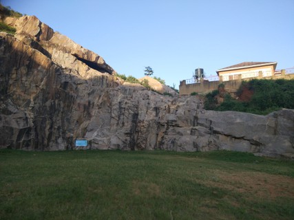
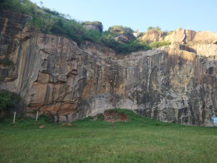
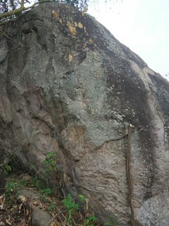
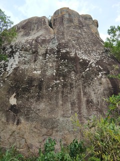
1.1. MCU Muyenga Quarry 27 routes in Crag
- Summary:
-
Sport climbing and Top roping
Lat / Long: 0.292047, 32.625305
summary
The only outdoor rock climbing within Kampala!
description
This crag has 20+ chain belays, and more routes are continuing to be developed by The Mountain Club of Uganda (MCU). Most routes are bolted for single pitch sport climbing, although a few are top-rope only. Both crag faces get afternoon shade, and climbing is great from about 2:30 pm to sunset at around 7 pm, which is consistent year-round in Uganda. On cloudy days, the rock stays cool enough that climbers can climb from sunrise to sunset.
MCU regularly runs climbing events at the quarry, where club equipment is available for rent to members who don't have their own gear. Check www.mcu.ug for a calendar of events.
access issues
This crag is closed until further notice.
Climbing here is only permitted to Mountain Club of Uganda members. Membership details at mcu.ug. It is around 15 USD per year to join and the club reinvests that money in bolting and retrofitting crags so please join up! Consider donating above the membership fees as well. Better yet, offer to help out by cleaning crags, bolting, running trips or carry some much needed club gear into your suitcase on your next flight to UG. Getting gear into the country is tricky and expensive, so bring everything you might need with you.
approach
To get to the parking area, take Kalungi Road to Kawagga Close and park at the Model House. Here is the pin to the parking area: https://goo.gl/maps/H9cmp5bEvgw
where to stay
As this crag is in Kampala, any accommodation in the city will work, but the closest neighborhoods are Muyenga, Makindye, Kabalagala and Bugolobi.
Camping is not allowed at this site.
ethic
The Mountain Club of Uganda is responsible for bolting at the quarry. Only the MCU committee can approve bolting. The landowner does not permit any other bolting. Contact www.mcu.ug for more details.
history
Pierre Gay Perret first noticed this crag whilst jogging. After many visits, he noticed the quarrying had stopped. After asking around a bit, the landowner was found and access was first granted to the Mountain Club of Uganda in November 2016. Cleaning and bolting yielded the first complete routes by January 2017.
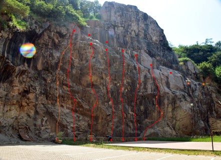
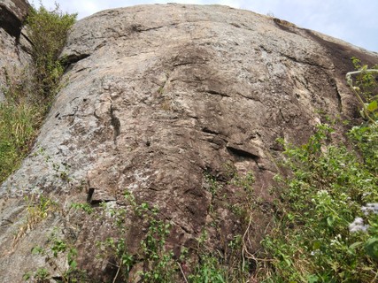
1.1.1. Right Hand Wall 27 routes in Sector
- Summary:
-
Sport climbing and Top roping
Lat / Long: 0.291925, 32.624589
description
This sector is child and beginner friendly. On the far right, there is a selection of the easiest routes rated 10-18. This sector also has a chain belay bolted near the ground for training/practice purposes which can be used to teach someone top rope setup or rethreading at the top of a lead climb. Often, first timers use this face to learn to abseil as it is an easy walk off if the climber decides not to abseil at the last minute.
approach
From the parking area, just walk into the center of the quarry. You'll see this sector on the right.
 |
||||||||
| Route | Grade | Style | Selected ascents | |||||
|---|---|---|---|---|---|---|---|---|
| 1 |
★★ chapati
FA: Pierre Gay Perret, 15 Jul 2017 | 11 FR:3c | 8m | |||||
| 2 |
★★ rolex
FA: Pierre Gay Perret, 2017 | {FR} 3b | 8m | |||||
| 3 |
★★ Matoke
FA: Pierre Gay Perret, 15 Jul 2017 | 11 | 8m | |||||
| 4 |
★ G nut
FA: Pierre Gay Perret, 15 Jul 2017 | 13 FR:4a | 8m | |||||
| 5 |
★ kasava
FA: Pierre Gay Perret, 15 Jul 2017 | 14 FR:4b | 10m | |||||
| 6 |
★★★ the seal
FA: Pierre Gay Perret, 15 Jul 2017 | 14 FR:4a | 9m | |||||
| 7 |
★★★ dibora
FA: Pierre Gay Perret, 15 Jul 2017 | 15 FR:4b | 10m, 4 | |||||
| 8 |
★★★ dibora bis
FA: Pierre Gay Perret, 2017 | FR:4c | 10m, 4 | |||||
| 9 |
★★★ misgana
FA: Matt Battani, 15 Jul 2017 | 14 FR:4b | 12m, 4 | |||||
| 10 |
To Bol
FA: Matt Battani, 15 Jul 2017 | 14 | 12m, 5 | |||||
| 11 |
★★ la proue
FA: Pierre Gay Perret, 15 Jul 2017 | 18 FR:5c | 12m, 2 | |||||
| 12 |
★ the open book
FA: Pierre Gay Perret, 15 Jul 2017 | 18 FR:5c | 17m, 4 | |||||
| 13 |
★★ on the eggs
FA: Pierre Gay Perret, 15 Jul 2017 | 17 FR:5b+ | 17m, 4 | |||||
| 14 |
★ le nid de guepe
FA: Pierre Gay Perret, 15 Jul 2017 | 17 FR:5b+ | 17m, 4 | |||||
| 15 |
★★ the multy pitch
Pitch 1: the hidden tnt hole 18m 4 bolt 5b Pitch 2: the balcony 30m (traverse most) 5 bolt 4a then 5b at the end. Perfect to learn multy pitch FA: Pierre Gay Perret, 2017 | FR:5b | 30m, 2, 5 | |||||
| 16 |
★★ The Hidden TNT Hole
FA: Pierre Gay Perret, 15 Jul 2017 | 16 | 15m, 5 | |||||
| 17 |
★ Side Pull
FA: Pierre Gay Perret, 1 Jun 2017 | {FR} 6a SA:19 | 18m, 5 | |||||
| 18 |
★★ The Black Stuff
FA: Pierre Gay Perret, 1 Jun 2017 | {FR} 6b SA:19 | 18m, 6 | |||||
| 19 |
★★★ Tooth Less
FA: Pierre Gay Perret, 1 Jun 2017 | {FR} 6a+ | 25m, 9 | |||||
| 20 |
★★ Arm Strong
Tooth Less Variante FA: Pierre Gay Perret, 1 Jun 2017 | {FR} 6b | 6m, 2 | |||||
| 21 |
★★ Arm Strong Rock Climbing
FA: Pierre Gay Perret, 15 Jul 2017 | 20 | 23m, 10 | |||||
| 22 |
★★ Arm Strong Variante
FA: Pierre Gay Perret, 15 Jul 2017 | 20 | 23m, 10 | |||||
| 23 |
★★★ Rasta Popoulos / Rasta Populos
FA: Benoit Fabre, 15 Jul 2017 | {FR} 6a SA:21 | 27m, 9 | |||||
| 24 |
★★ Mental
Rasta Popoulos variante FA: Pierre Gay Perret, 1 Jun 2017 | {FR} 6a+ | 6m, 2 | |||||
| 25 |
★★ Le Cristal de Muyenga
FA: Pierre Gay Perret, 1 Sep 2017 | {FR} 6b+ SA:20 | 20m, 7 | |||||
| 26 |
★★★ l'Epée de Damoclès
FA: Benoit Fabre, 1 Sep 2017 | {FR} 6c+ SA:24 | 22m, 7 | |||||
| 27 |
★ Benoit
FA: Benoit Fabre, 15 Jul 2017 | 24 | 21m | |||||
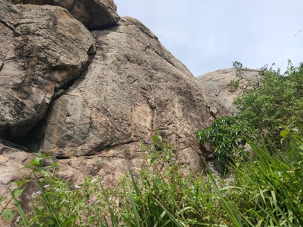
1.1.2. Left Hand Wall 0 routes in Unknown
description
You'll find the longest routes here. Grades vary from 19-24. All these routes have walk around top-rope access. The highest route is 27m, so a 60m rope is good enough.
 |
1.2. Bukasa quarry 12 routes in Area
- Summary:
-
All Sport climbing
Lat / Long: 0.290913, 32.625877
summary
following the temporary closing of the first Quarry, MCU found a new place to climb.
description
This crag has 10+ chain belays, and more routes are continuing to be developed by The Mountain Club of Uganda (MCU). Most routes are bolted for single pitch sport climbing, although a few are top-rope only. Both crag faces get afternoon shade, and climbing is great from about 2:30 pm to sunset at around 7 pm, which is consistent year-round in Uganda. On cloudy days, the rock stays cool enough that climbers can climb from sunrise to sunset.
MCU regularly runs climbing events at the quarry, where club equipment is available for rent to members who don't have their own gear. Check www.mcu.ug for a calendar of events.
access issues
Climbing here is only permitted to Mountain Club of Uganda members and Anjuman-E-Burhani Masjid members (if accompagnied by a MCU members). Membership details at mcu.ug. It is around 15 USD per year to join and the club reinvests that money in bolting and retrofitting crags so please join up! Consider donating above the membership fees as well. Better yet, offer to help out by cleaning crags, bolting, running trips or carry some much needed club gear into your suitcase on your next flight to UG. Getting gear into the country is tricky and expensive, so bring everything you might need with you.
approach
where to stay
As this crag is in Kampala, any accommodation in the city will work, but the closest neighborhoods are Muyenga, Makindye, Kabalagala and Bugolobi.
Camping is not allowed at this site.
ethic
The Mountain Club of Uganda is responsible for bolting at the quarry. Only the MCU committee can approve bolting. The landowner does not permit any other bolting. Contact www.mcu.ug for more details.
The crag is the property of Anjuman-E-Burhani Masjid and
1.2.1. the capitan of Bukasa 12 routes in Area
- Summary:
-
Lat / Long: 0.291033, 32.625779
1.2.2. Beginner wall 0 routes in Area
1.3. International School of Uganda 0 routes in Artificial
summary
A 6m x 6m indoor climbing wall for bouldering and top-rope only. ISU's wall has some overhangs and features built in and routes from 12-25 in grade.
description
The ISU climbing wall now has capacity for five climbers at a time. ISU has an after school climbing activity for its students every Tuesday. The Mountain Club of Uganda runs indoor climbing here once a month on Tuesdays from 7-9pm. There are usually 15-25 people at these sessions, which are popular and often oversubscribed. A group of 10-15 on this wall is plenty. If you'd like to use this wall contact ISU directly or attend one of the MCU sessions. Club sessions should increase in frequency to meet demand, however too few volunteers exist to run more sessions. Ideally, this small wall should be open a couple evenings per week to meet demand.
approach
Park at the ISU main parking lot and walk up to the sports hall. (see map above)
history
This is the only indoor climbing in UG as of March 2018. The wall was built around 2011 and was expanded in 2015.
There have been many other attempts by the MCU and others to expand indoor climbing in Kampala. There is a planned gym for Rubaga, which is stalled, another halted gym in Makindye and several other international schools have tried to put a gym in place. Sadly the money and/or expertise has been lacking and none of those projects have come to fruition leaving ISU with the only indoor climbing in Uganda.
1.4. Nsiita 24 routes in Area
- Summary:
-
Sport climbing, Bouldering and other styles
Lat / Long: 0.537579, 32.726270
summary
Insita is Uganda's largest, best, and oldest sport crag.
description
This is a great place for beginning climbers and those aiming to up their game as well. There are about 20 bolted sport routes with grades from 12-23 and some tough bouldering as well. If you are looking for established 25s or harder, Insita, and Uganda for that matter, is not the place for you unless you'd like to pioneer your own lines. In that case, we need you! The Mountain Club of Uganda organizes monthly trips to Insita and on those days, this crag can be quite full. Most days you'll have this crag all to your self.
access issues
Free for everyone. Insita Luwazi is on community land. Climbers have always had a warm welcome. We pay 3000 Uganda Shillings to park at a nearby house. There is some occasional conflict in the community about who should get those shillings. Up to now, this has not affected the climbers. Call Ishma at: 0773 128 861 and tell him you are coming or just show up. He will let you park in front of his house and can show you around the crag if needed. Ishma maintains the trail to Insita and can clean/thrash the belay area if needed. You can also buy local food and produce from Ishma if you choose. Climbing at camping at Insita Luwazi is free.
approach
Leave Kampala via the Gayaza road. At Kalagi, turn left. Shortly outside of the town, turn left again at the Y intersection. Then, upon reaching the village of Kijjo, turn left again. This road will take you directly to Ishma's house. Find the parking at Ishma's house here: https://goo.gl/maps/MLKz4ry9fMQ2
Note: more than a few people have attempted to use Google Maps to navigate directly to Insita/Luwazi. As they navigate to the dome of rock itself, Google takes them to the wrong road on the wrong side of the rock and they end up either very lost or hiking through awful bush to get to the rock. A better approach is to set your navigation to Ishma's house, turn off the main road exactly at Kalagi, and then follow the directions above.
From the parking area at Ishma's, hike behind his house, through his field and straight for the granite dome. You'll see Elie's Boulder along the way. Hike up and over the dome trending left and you'll see the belays bolted on the far side. The easiest hike down is just left of the bolted routes, but you can get down on the far right as well. Many climbers choose to rap down to the belay area and as the routes are all single pitch and 13m high or less, even a shortish rope is long enough reach the bottom on a short rappel.
where to stay
You can camp on top of Insita or camp in Ishma's garden. Kampala is about an hour away, so accommodation in Kampala is most convenient. As Luwazi is small, it is usually just a day trip.
ethic
Insita is pretty developed, so there isn't much room to bolt new routes. If you see a line you'd like to add, please check with the Mountain Club of Uganda.
history
"Discovered" in 1962, this crag gets mentioned at the end of the 1962/63 guidebook. The first routes were presumably set by D Pasteur and H A Osmaston, but the old guidebooks do not attribute FAs to the routes at Insita.
In the late 1980s and early 1990s, this crag was expanded by L Raaum and his son R Raaum. Those FAs were included in the 1991 edition and have been updated here.
Insita was rebolted/retrofitted and expanded from 2014-2018 and that work is now 90% finished. A few belays/lower offs need to be added to routes sharing chains. Pierre Gay Perret has completed most of this work.
1.4.1. Elie's Boulder 4 routes in Boulder
- Summary:
-
All Bouldering
Lat / Long: 0.538393, 32.726987
description
A nice selection of tough problems and opportunities for FAs!
The descent is tricky. Basically, climb down the tree covered in biting ants.
In the future, to make bouldering here safer, Ishma could be hired to clear the area around the bottom. Careful not to damage the tree as it is really needed for all descents.
approach
You'll see this boulder on the left of the main trail up to Insita.
history
Discovered and opened by Elie Bou-Gharios in 2015. Locals have told us climbers used this boulder in the 90s, but we have no descriptions or record from them.
     |
||||||||
| Route | Grade | Style | Selected ascents | |||||
|---|---|---|---|---|---|---|---|---|
| 1 |
Termite Be Your Last Breath
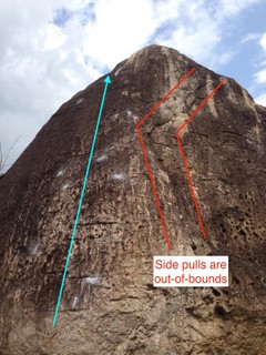
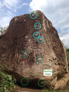
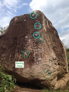
This is the harder, sit start variation of the V5 Termite Be Your Last Step. This climb is a project and has yet to be sent. Very sharp slab with a slightly positive incline. Incredibly small holds and bad footholds. All side pulls to the right of the holds are out-of-bounds, see photo below. Start sitting on the small rock beneath the boulder and pull up off the ground on the left-hand side pull and the right-hand three-finger sloper, as shown in the beta photo. First move is a big, right hand throw to a small crimp (Crux move). Then left hand to the small, sharp crimp above your right hand, chalked intermediates can be seen in the photo. Then right hand to the wide sloper pinch directly above and bring your feet up. Right foot high, stand up, reach for the left hand side pull and lean back on it. Crank in with the left and find a good, wide sloper above and then top. Set: Elie Bou-Gharios, 2015 | V7 | 4m | |||||
| 2 |
Termite Be Your Last Step
This is the easier, stand start variation of the V7 Termite Be Your Last Breath. Very sharp slab with a slightly positive incline. Incredibly small holds and bad footholds. All side pulls to the right of the holds are out-of-bounds, see photo. Start standing on the small rock beneath the boulder and pull up off the ground on the left-hand side pull and the right-hand crimp, as shown in the beta photo. First move is left hand to the small, sharp crimp above your right hand, chalked intermediates can be seen in the photo. Then right hand to the wide sloper pinch directly above and bring your feet up. Right foot high, stand up, reach for the left hand side pull and lean back on it. Crank in with the left and find a good, wide sloper above and then top. Set: Elie Bou-Gharios, 2015 FFA: Elie Bou-Gharios, 2015 FA: Elie Bou-Gharios, 2015 | V5 | 4m | |||||
| 3 |
★ Short Haul
Easy, stand start, warm-up route on great pockets and abundant footholds, should be mandatory climbing for all who visit Luwazi. Set: Elie Bou-Gharios, 2015 FFA: Elie Bou-Gharios, 2015 FA: stand start, warm-up route on great pockets, abundant footholds, should be mandatory climbing for all who visit Luwazi. & Elie Bou-Gharios, 2015 | V0 | 4m | |||||
| 4 |
★ Play Time
Start with the tree a meter or two to your left. Use the jugs to get off the ground. Then, step right onto the small ledge. From there, just friction climb to the top. Use the tree to descend. | V0 | 4m | |||||
1.4.2. Nsiita's Right Hand Wall 5 routes in Sector
- Summary:
-
Sport climbing and Top roping
Lat / Long: 0.536599, 32.725181
description
There are five routes on Insita's Right Hand Wall rated between 14-18. There are four bolted sport routes and one top rope project.
approach
From the top of Insita, turn left towards the bushy gulley and descend it. At the bottom of this easy descent, turn right. After walking just a couple meters, you will see Insita's first bolted route, Le Bataclan. From here, follow the wall around the corner. All of Insita's routes are ahead of you clustered in the next 50 meters.
descent notes
Careful to choose the right gulley to descend. It should be a very easy if dry. Note: There are other ways to descend which are also easy. You can approach the rock from any side.
history
This wall is the latest addition to Insita and all bolting took place from 2014-2017.
 |
||||||||
| Route | Grade | Style | Selected ascents | |||||
|---|---|---|---|---|---|---|---|---|
| 1 |
★★ Le Bataclan
Set: 2015 FFA: 2015 FA: Pierre Gay Perret, 2015 | 17 | 10m, 5 | |||||
| 2 |
★ Why?
Set: 2016 FA: Matt Battani, 2016 | 18 | 10m | |||||
| 3 |
Je Suis Charlie
Set: 2015 FFA: 2015 FA: Pierre Gay Perret, 2015 | 16 | 10m, 5 | |||||
| 4 |
The Fallow Fields
FA: J Bull & C Mallen, 1991 | 16 | 10m, 6 | |||||
| 5 |
★ I Don't Know
Set: 2015 FFA: 2015 FA: Pierre Gay Perret, 2015 | 15 | 10m, 5 | |||||
1.4.3. Nsiita's Main Wall 6 routes in Sector
- Summary:
-
Mostly Sport climbing
Lat / Long: 0.536757, 32.725137
description
A great spot to climb. A couple small trees partially shade the belayers here, but the wall is pretty sun exposed most of the day. Some of the routes share belays and some are missing mallion, so take some biners and slings with you to build anchors where necessary. All can be setup for top rope and all hardware can be retrieved from the top of the crag afterwards.
There are six routes on this wall including the hardest and easiest climb at Insita. The left side has great crack climbing which can be trad climbed and is only bolted for top rope.
approach
Just left of the right hand wall.
 |
||||||||
| Route | Grade | Style | Selected ascents | |||||
|---|---|---|---|---|---|---|---|---|
| 1 |
Forest Wall
FA: D Pasteur & H A Osmaston, 1962 | 12 | 9m, 5 | |||||
| 2 |
Fancy Free
FA: L Raaum & R Raaum, 1991 | 17 | 10m, 6 | |||||
| 3 |
★★ Thief's Wall
FA: L Raaum & R Raaum, 1991 | 18 | 10m, 6 | |||||
| 4 |
★★ Captain Trips
FA: L Raaum & R Raaum, 1991 | 19 | 11m, 6 | |||||
| 5 |
★★★ The Lay Backs
FA: D Pasteur & H A Osmaston, 1962 | 20 | 11m, 6 | |||||
| 6 |
★★★ The Crack
FA: D Pasteur & H A Osmaston, 1963 | 18 | 11m | |||||
1.4.4. Nsiita's Corner 3 routes in Sector
- Summary:
-
All Sport climbing
Lat / Long: 0.536920, 32.725166
description
The obvious corner after passing the right hand wall and main wall. The hardest sport routes are here. This is the center of the Insita Crag. It has some of the most pumpy moves and only established overhangs in Uganda.
 |
||||||||
| Route | Grade | Style | Selected ascents | |||||
|---|---|---|---|---|---|---|---|---|
| 1 |
★★ Magnets
FA: L Raaum & R Raaum, 1991 | 18 | 12m, 6 | |||||
| 2 |
★★★ Ishma's
Set: 2015 FFA: 2015 FA: Pierre Gay Perret, 2015 | 21 | 13m, 6 | |||||
| 3 |
★★★ Madness is a Flexible Bullet
FA: L Raaum & R Raaum, 1991 | 21 | 12m, 6 | |||||
1.4.5. Nsiita's Left Hand Wall 6 routes in Sector
- Summary:
-
Sport climbing, Trad climbing and Top roping
Lat / Long: 0.537095, 32.725291
description
There is a good selection of easier routes on this side. The Egyptian is a super popular intermediate top rope route, but it has been trad climbed as well. These climbs are a bit shorter than on the other areas and a number of them have only one difficult move. The rock here slopes more positively making the routes mostly walk ups with the cruxs being near the ground.
This is the far end of the crag if starting from the right. This is shaded in the morning, so get here early and bag these routes before it turns into an oven.
 |
||||||||
| Route | Grade | Style | Selected ascents | |||||
|---|---|---|---|---|---|---|---|---|
| 1 |
★ Vice Chimney
FA: D Pasteur & H A Osmaston, 1962 | 17 | 11m | |||||
| 2 |
★★★ George's Corner / The Egyptian
FA: D Pasteur & H A Ostmaston, 1962 | 20 | 10m | |||||
| 3 |
Jean's Wall
FA: D Pasteur & H A Ostmaston, 1962 | 17 | 10m, 5 | |||||
| 4 |
★ Original Route
FA: D Pasteur & H A Osmaston, 1962 | 18 | 10m, 5 | |||||
| 5 |
Mantle Shelf Wall
FA: D Pasteur & H A Osmaston, 1962 | 19 | 10m, 5 | |||||
| 6 | ★★ Face to Face | 23 | 10m | |||||
1.5. Ketabya 0 routes in Crag
summary
Another gorgeous cluster of boulders and pillars about 2km from Insita/Luwazi. Many of the lines look too hard for most climbers. There are some ramp slabs that could be bolted.
description
A beautiful, yet undeveloped/unclimbed area near Kampala. Natural anchors are great in some places, but missing in others. Mostly, this area would need some bolts. Rock is 13-15m high.
Lots of the starts are overhung. This is similar to Kkungu and Kasaayi. However, once the start is overcome, more possible lines appear.
The rock is excellent quality and has never been climbed. You can see this rock from Luwazi. It's in a cluster of trees and a bit hard to spot.
access issues
Access was granted freely. The local population was friendly. They did ask for money, but we didn't pay. If you park or camp nearby, you'd need to pay a little something for that.
approach
There is a road directly at the foot of this rock, but it is hard to find. We approached by jogging from Insita. You'd need a local guide or to study satellite maps a bit to find the right road leading to Ketabya.
where to stay
Stay in Kampala or bush camp nearby.
ethic
This community is pretty unfamiliar with climbing/climbers. Be careful to develop a positive relationship for future climbers. Locals have some awareness of our sport due to the long tradition of climbing nearby at Insita.
history
We found this rock in 2016. However, we didn't have enough strong climbers to warrant it's development. We only had one drill and were focused on developing other sites like Rwakobo, Pierre's Quarry, Kkungu and Chema. This rock, along with Kasaayi could be bolted to greatly increase the number of sport routes near Kampala.
1.6. Nakwero Rock 0 routes in Crag
summary
So far unclimbed, this slab has potential, but would need to be bolted and routes look quite hard. It looks like the main pillar has never been summited by anyone, so FA away!
description
There is a gorgeous cluster of huge boulders and pillars at this site. Most have overhung starts with few features/holds. I have a video of the area. If you are interested, I'll send it to you.
I think the lines here are too hard for most climbers, which is probably why nobody has developed it yet.
access issues
Local community was friendly, didn't ask for money and welcomed us to climb.
approach
Park just off the main road. From there it is just a minute or so up to the crag.
where to stay
Stay in Kampala or camp nearby.
ethic
Try to develop a positive impression of climbers as this community isn't familiar with our sport/lifestyle. Please don't pay for climbing as climbing at almost all UG crags is free. Maybe pay a little money for parking or buy some produce to contribute to the local economy.
history
We have been seeing this for years on our way to/from Insita. It's never been climbed or developed.
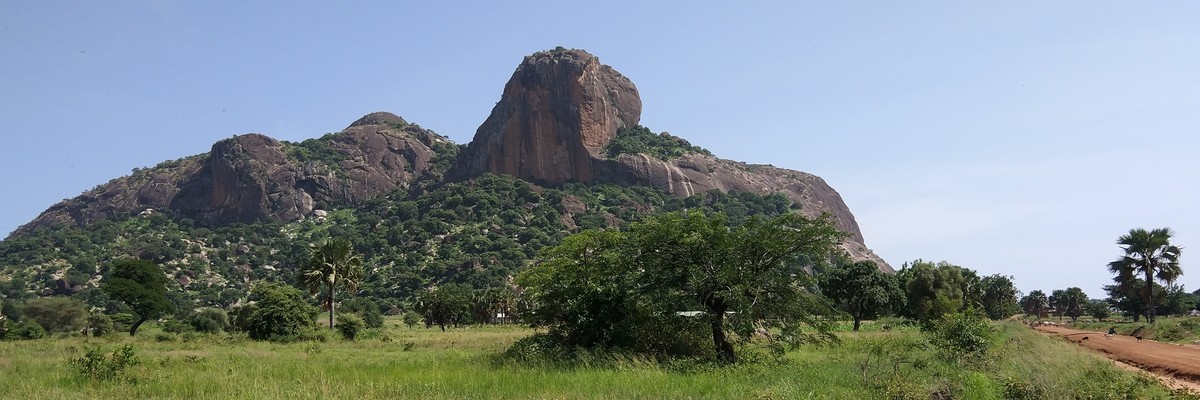
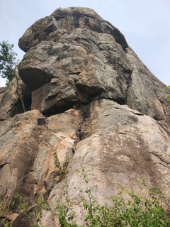
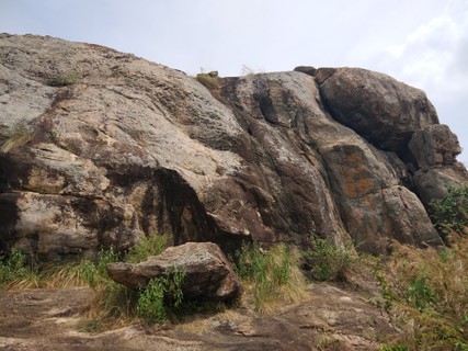
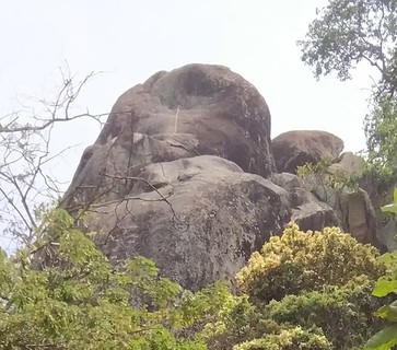
1.7. Kkungu Rock 15 routes in Area
- Summary:
-
Mostly Top roping
Lat / Long: 0.491931, 32.509491
summary
40m sheer inselberg with excellent single-pitch, top-rope climbing. Some of the hardest climbs in the country are here. Still under development, this could become one of the best crags in Uganda.
description
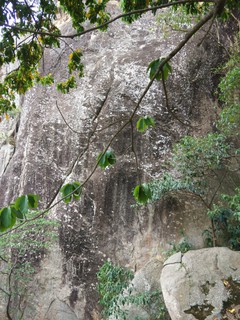
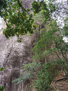
The 40m tall, sheer inselberg of Kkungu is an excellent single pitch, top rope crag containing many of the hardest known climbs in Uganda. It’s also an eye-opening holy site for the local demigod, Kkungu. Located just a few minutes from Matugga or about 45 minutes outside of Kampala (avoiding traffic), this crag should be bolted for sport climbing at some point in the near future for which the locals have given their blessing.
This crag is located within a fascinating local community. Consequently, you have small shops, a rolex stand (fried/rolled eggs in chapatti), toilets and local restaurants just a two-minute walk from the rock.
Take an 80m rope if you want to try all the routes. If you don't have an 80m, take a 70m or 60m, which are long enough for a many of the routes. If your rope is too short, belay from top but take sunscreen as the top of the rock and upper sections above the jungle can be incredibly hot. The belay area and first moves are shaded all day. The entire area is gorgeous jungle. Bird life is outstanding.
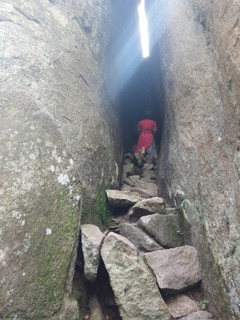
You'll find a very prominent prayer crack on the east side. Locals have told me that God created all the earth including Kkungu Rock and that God gave demigods certain powers. They believe Kkungu is a demigod with wide ranging powers. Local devotion to Kkungu has lasted over four centuries, long before Christians arrived. You'll see more evidence here of a thriving indigenous religion than maybe anywhere else in Uganda, but it is mixed with Christian influences as well.
The entire area is considered sacred. You see many worshippers most afternoons. Offerings to Kkungu of coffee, coins and cowrie shells are common. The area is marked out with very many spears meant to demonstrate the god’s power.
Please be respectful when moving around the area. Worshippers are very friendly, curious and keen to climb with you. Take extra gear if you can and invite locals to join in the climbing!
access issues
There is a warm, friendly and curious local community. Previous climbers have negotiated to pay a 5k parking fee to the rock’s security man, Omar. Please be respectful and help preserve the nice relationship. Religious ceremonies take place at the rock on Tuesdays, Thursdays, Saturdays and Sundays. Climbers in small groups have been allowed to climb on these days, but they are best avoided. Permission for Monday, Wednesday, and Friday climbs have been granted by the local community, but small, quiet, respectful groups of climbers have never been turned away, regardless of the day. Chances are, you've never seen a site like this!
approach
Head north out of Kampala on Bombo Road, which is also the Masindi or Gulu Highway. This road will take you to the town of Matugga. Go through Matugga staying on the Masindi Highway. About 2.5km after Matugga, you will see a left turn heading sharply downhill on a rough murram road. Take this turn and proceed about 2km, then turn right. This road will lead you into a small village with a couple shops. Take the right turn at the village. SK Primary School should appear almost immediately on your left.
Drive past the SK Primary School. From there, the road quickly becomes a dead end. Park conscientiously on the side of the road. The rock is just in front of you. Approach time is less than one minute from the parking area.
where to stay
Bush camping nearby is possible. Permission to camp on top the rock has been granted, but groups haven't tried this yet. There is also a guest house in Kkungu with gated parking, grassy patches for tents and some rooms. However, climbers usually just stay in Kampala.
ethic
Please be respectful of the local religious ceremonies. Please bolt at a minimum. To this point, we have only used stainless steel expansion bolts which should last for several generations. If you bolt, please only use top quality equipment.
history
When exactly this rock was first climbed is not known. In 1961, Kkungu was climbed by Andrew Stuart to aid local police in the apprehension of an armed witch doctor for which he became the only non-policeman to win the Colonial Police Medal.
The rock was used in the 90s as well for abseiling training. Modern climbing was established in early 2016. Bolting began in the summer of 2017. As of February 2018, seven top rope anchors and one sport route had been bolted.
1.7.1. Main Inselberg 12 routes in Sector
- Summary:
-
Mostly Top roping
Lat / Long: 0.491904, 32.509245
description
Only one of the routes here has been bolted for sport climbing. Very little pro placements are apparent. Scramble to the top via Thin Man's Crack/Normal Route and set top ropes from there to do these climbs.
   |
||||||||
| Route | Grade | Style | Selected ascents | |||||
|---|---|---|---|---|---|---|---|---|
| 1 |
★★ Northeast Corner Left Seam
Set: Adam Herring FA: Adam Herring & Alex Fisher | 17 | 30m | |||||
| 2 |
★★ Northeast Corner Slab/Ramp
Go straight up the slabs avoid using the seems on the left. Set: Adam Herring FA: Adam Herring & Alex Fisher | 18 | 30m | |||||
| 3 |
★★ Northeast Corner Right Slab
Set: Adam Herring, 5 Feb 2018 FA: Adam Herring & Alex Fisher, 5 Feb 2018 | 17 | 30m | |||||
| 4 |
★★ Northwest Corner
After an assisted start with a bamboo ladder, follow the easy arete to the chain. Set: Matt Battani, 5 Feb 2018 FA: Adam Herring & Alex Fisher, 5 Feb 2018 | 17 | 28m | |||||
| 5 |
★★ Normal Route
To access the top via the normal route, you must move through then up the prayer crack, and then squeeze out the Thin Man's Crack to the ledge. If the squeeze is too tight, use the chimney. After exiting the crack onto the ledge, turn left and scramble up the large boulder. You'll find two belay chains up there for the routes on the southwest. Then, go back down the boulder towards the prayer crack and move towards the north side of the rock where you'll find a short but exciting little lead route bolted to help you to the very top of Kkungu Rock. Approximately 9m and 5 clips (20). Enjoy the view and wave to the school children. Set: Matt Battani, 5 Feb 2018 FA: Matt Battani, 5 Feb 2018 | 20 | 9m, 2, 5 | |||||
| 6 |
★★ Classic North Face Route
This route shares the chain belay with Normal Route. It is a long and very challenging route that should be developed for sport climbing at some point. FA: Alexandra Fisher, 28 Oct 2017 | 22 | 37m | |||||
    |
||||||||
| Route | Grade | Style | Selected ascents | |||||
| 7 |
★ Thin Man's Crack
Move through the prayer crack pictured. On prayer days, be respectful and wait your turn. At the far end of the crack, squeeze out to the top or use the chimney to the exit on the ledge. From the ledge, you can access the Normal Route and a number of the top rope chains. Alternatively, you can access the top via the easier Northeast corner routes, however, as these are not yet bolted for lead climbing, the Normal Route is the only protected way to the top. | 17 | 3m | |||||
| 8 |
★★★ Main Crack (Cleft East Face)
From the prayer crack, there are a variety of chimney routes to the top. The crack is quite wide, but narrow enough to chimney in a few places. Protection is either poor or non-existent, so set a top rope and enjoy! Nothing in the prayer crack has been bolted as of Feb 2018. | 18 | 20m | |||||
| 9 |
★★ South Slab
FA: Benoit Fabre, 5 Feb 2018 | 24 | 35m | |||||
| 10 |
Southeast Corner
FA: Hugo Hotte, 5 Feb 2018 | 20 | 25m | |||||
| 11 |
★★★ Classic South Face Route
Set: Matt Battani FA: Matt Battani, 5 Feb 2018 | 24 | 30m | |||||
| 12 |
★★ Southwest Corner
Set: Thijs Van Laer FA: Thijs Van Laer, 5 Feb 2018 | 23 | 29m | |||||
1.7.2. Secondary Slab 3 routes in Sector
- Summary:
-
All Top roping
Lat / Long: 0.491770, 32.510016
description
There is nothing bolted here as of February 2018. Scramble to the top on either side of the slab. There is ample room for a number of cams to build a bomber top-rope anchor.
approach
From the parking, walk to the main inselberg. Turn slightly left up the trail and you'll see this slab on your left within a minute or two.
 |
||||||||
| Route | Grade | Style | Selected ascents | |||||
|---|---|---|---|---|---|---|---|---|
| 1 |
Left
FA: Hugo Hotte | 22 | 15m | |||||
| 2 |
★★ Center
FA: Matt Battani | 22 | 15m | |||||
| 3 |
Right
FA: Hugo Hotte | 21 | 15m | |||||
1.8. Kyungu 0 routes in Crag
summary
A crag from the old days. Not bolted. Some easy alpine style climbing. Today, it is overgrown. However, if you want an easy crag near Kampala, consider rediscovering and developing this one.
description
Located on a beautiful, local, extremely diversified farm. If you want to see the best of what is growing in Buganda, this farm is for you. Also, a nice place to hang out and relax in central UG.
Best explored in dry season. You could ask Deo to burn or slash the belay area to help you access the rock.
Routes here are very short, mostly less than 7m.
If you wanted a place to do very easy, single-pitch trad as a learning crag, this could work. Otherwise, this crag is worth a miss.
access issues
Contact Deo Lubega, the elder/patron of the Mountain Club of Uganda. His family owns this land. Access is free and unrestricted for contributing members of the local climbing and mountaineering community.
approach
Expect one hour drive from central Kampala in light traffic. Here are the coordinates: 0.3248778, 32.731983
Namilyango was the name in the old guidebooks, but that is a pretty misleading name because the rock isn't very near to Namilyango. Better head to Kyungu and use the coordinates provided.
where to stay
Stay in Kampala or pitch your tent in Deo's garden.
ethic
Ask Deo if you'd like to change anything here.
history
A crag mentioned in both the 1962/3 and 1991 guidebooks, the land has been purchased by a Mountain Club of Uganda member and farmed. It is deserted and overgrown as of 2018.
1.9. Nakasongola 0 routes in Area
summary
In the old days, this was the best/most popular crag in Uganda. Many references can be found in the 1962 and 1991 guide books. The area has been closed since 1992 due to proximity to a military base
description
The hard, grey gneiss has been described as excellent. Prior to 1992 this area provided the best climbing within reasonable reach of Kampala.
access issues
Several attempts to gain access have been made from 2012-2018. As of yet, the base commander will not let climbers back onto these crags. As the climbing community grows, hopefully someone with the right approach and connections can help plead the case for climbing here as re-opening Nakasongola would undoubtedly greatly enhance climbing opportunities for the Kampala based climbing community.
approach
See the old guidebooks or follow the GPS coordinates.
where to stay
This can be reached from Kampala. Alternatively, use a local guesthouse or bush camp nearby.
ethic
Be prepared for a hostile welcome if you try to get into this site.
history
Prior to 1992 this was the key climbing area in Uganda. Post 1992, groups have been forbidden from climbing here and even escorted away by armed soldiers.
1.10. Mubende 0 routes in Area
summary
A promising area that needs to be explored. Zero known climbing up to this point.
description
When driving from Kampala to Fort Portal, you cannot miss all the large granite domes and boulders easily viewable from the main road. Nothing yet has been discovered that is good for climbing as the domes are not vertical enough for climbing. However, Insita, which is one of the best climbing sites in the country is a granite dome with one steep section. The quality of rock is excellent and there must be lots of climbing in the Mubende area.
It is very hard to describe to a local Ugandan what type of rock climbers are looking for. I have taken many exploratory trips around Uganda with local people. Ugandans always show me huge rocks, but rarely, if ever are they suitable for climbing for one reason or another. It will be essential to train up some local people in climbing to help identify new crags, which must be plentiful in this area and around most of the country. Exploring this area has been time consuming and not yielded much worth noting, but most of the area has not yet been explored by climbers.
access issues
Access has not been discussed or negotiated with the local community.
history
No historical references to any climbing in the area has been published in previous guidebooks or websites.
1.11. Rwakobo Rock 9 routes in Crag
- Summary:
-
Sport climbing, Top roping and Bouldering
Lat / Long: -0.528094, 30.999899
summary
A small, but excellent climbing area with some well bolted routes and potential for expansion.
description
Rwakobo Rock 0°31'42.2"S 30°59'58.4"E The entire area around Lake Mburo National Park has rock climbing potential. Many rocks are easy scrambles, but with a bit of searching and asking around, good bouldering, sheer faces for top rope and trad climbing can be found. The “Top of the Rock” section at the Rwakobo Rock Lodge was developed in early August 2017 with eight routes added at that time (six for lead and two top-rope only). The routes vary in length of just 4m for beginners to 12m and SA grades from 14-25. More sport routes could certainly be added and a few interesting bouldering problems can be found nearby.
Note: the area around Monkey tent has potential for development once brush is cleared and access granted by the owner.
As of February 2018, this is the only bolted/documented section of Rwakobo. All routes accessible to setup top rope. An extra safety bolt was placed at Top of the Rock to help facilitate this.
Baboons are a real problem at this crag. They have learned to enter the lodge and steal food and other possessions. If you walk around through the woods, you'll see lots of items that have been stolen and then discarded by the baboons. Keep your car windows up and your doors shut. Keep all your possessions in your bag close to you. Several climbers here have had shoes and other small items swiped by these sometimes not so little pests.
access issues
Granted free to climbers by the owner of the Rwakobo Rock Lodge. From Rwakobo, you can explore many other rocks, but keep in mind the national park entrance is nearby. Many rocks exist inside the national park, which charges high entrance fees. Nothing inside the park has been developed due to these fees.
approach
Driving Directions: Exit Kampala via on the Masaka/Mbarara Road. You’ll make a left turn toward Rwakobo Rock about 14kms after Lyantonda at the tiny town of Akegeti. There is a large sign directing you to Rwakobo Rock, which is also on Google Maps. Park at the lodge.
Use the main parking area for the lodge and follow the signs to “Top of the Rock”. Approach from parking to crag is less than five minutes.
Alternatively, to avoid disturbing the lodge's guests and to have a shorter approach, you can park at the bicycle rental shed and cut through the bushes towards the boulders.
where to stay
Rwakobo Rock is a fantastic place to stay, eat, drink and see great wildlife. If you’re looking for something cheaper, Leopards Rock Campsite is nearby, or you can stay in a very basic guesthouse nearby in the town of Akegeti.
ethic
Rwakobo Rock is a popular, upscale lodge with many guests. Please be quiet and respectful. Free access to this rock has been generously granted to climbers, so please strive to keep this a strong and positive relationship. The rock is privately owned, so make sure to seek permission from the lodge management if you wish to bolt or explore beyond the establish climbing areas.
history
Permission to bolt was granted in 2015. Bolting started in July 2017. Up to Feb 2018, only top quality, stainless steel expansion bolts had been used in the area.
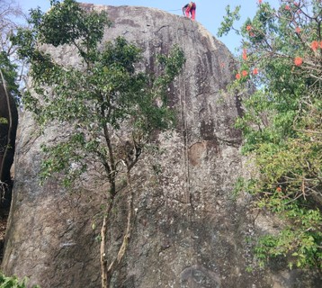 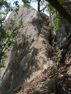 |
||||||||
| Route | Grade | Style | Selected ascents | |||||
|---|---|---|---|---|---|---|---|---|
| 1 |
★★ Skin Doctor
FA: Uwe Pitsch, 7 Aug 2017 | 23 | 12m, 6 | |||||
| 2 |
★★★ Miss May
FA: Bianca So, 15 Sep 2017 | 24 | 12m | |||||
| 3 |
★★★ G-Nuts and Bolts
FA: Nathalie MacKinnon, 7 Aug 2017 | 21 | 12m, 5 | |||||
| 4 |
★ The Fifth Bolt / Choose Wesley/Polish Sausage/Kielbasa
FA: Matt Battani, 7 Aug 2017 | 19 | 12m, 6 | |||||
| 5 |
★ Snorting Crags Through a Straw
Follow the clips along the far end of the face and avoid the gulley. FA: Matt Battani, 7 Aug 2017 | 17 | 12m, 6 | |||||
 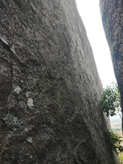 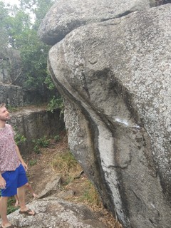 |
||||||||
| Route | Grade | Style | Selected ascents | |||||
| 6 |
★ To Tree or Not to Tree
This route was graded without the use of the tree. Top rope access is only possible by scrambling up the end of this large boulder. FA: Uwe Pitsch, 7 Aug 2017 | 18 | 9m, 4 | |||||
| 7 |
Tree Hugger
A good beginner/learner route for lead climbing. Sling the tree for extra pro if needed. FA: Matt Battani, 7 Aug 2017 | 14 | 8m, 4 | |||||
| 8 |
★★ Rwakobo Chimney
Go up the chimney. Rock over onto the main wall. Straight up to the chain. Bolted for top rope only. FA: Wieslaw Rutkowski, 7 Aug 2017 | 22 | 10m | |||||
| 9 |
★★★ Misogynist Baboon
You can find the boulder just a few minutes away from "Top of the Rock". Head toward the volleyball courts and you'll see it on your left. FA: Jack Adams, 7 Aug 2017 | 25 | 4m | |||||
1.12. Kilembe 11 routes in Crag
- Summary:
-
Sport climbing, Trad climbing and Top roping
Lat / Long: 0.213805, 30.002858
summary
A beautiful climbing area above a river, but small and only a couple good routes, Kilembe is worth checking out only if you are nearby. There is also potential for further development.
description
Not the best climbing in the country, but a couple nice routes nonetheless. If you are doing a Rwenzori Trek via the Kilembe Trail, you are right near the trailhead, so take your climbing gear for a little cragging before/after tackling the Rwenzori.
access issues
Free and unrestricted. The local tour company, Rwenzori Trekking Services, helps climbers use this crag.
The benefit here is that it is outside the national park (RMNP), so you can climb here and avoid the high park fees.
approach
Park at the Trekkers/Backpackers (Rwenzori Trekking Service (RTS)) hostel. From there, you can easily walk to the crag. With directions from the hostel staff, it is easy to find and shouldn't take more than 10-20 mins. The coordinates are: 0.21083333, 30.00527778. It is just above the river and only about 1km from the hostel.
To find on your own without RTS or GPS help, the climbing 'wall' is on the right side of the first bridge encountered when heading from Backpackers hostel in Kilembe towards Kasese.
where to stay
RTS hostel
ethic
This part of Uganda sees lots of foreign trekkers heading into the Rwenzori, so a few climbers will be no surprise to local people. The welcome is nice and friendly. I suspect developing this crag would be welcomed by the local people, though there isn't much room for further bolting.
history
This crag has been used to train RTS guides in rappelling. It isn't actually climbed very often. The French military has also used this crag to train Uganda's soldiers (UPDF) in rappelling.
| Route | Grade | Style | Selected ascents | |||
|---|---|---|---|---|---|---|
| 1 |
★★ Aloe Vera
Rap down to the start as there is no trail to the base of this crag. This goes for all routes at Kilembe. | 12 | 20m, 5 | |||
| 2 |
Charlie's Route
Oreochromis Niloticus is a few meters to the left. The two routes join part way up. Crux is near the bottom of this one. | 17 | 28m | |||
| 3 | Coleus Prime | 10 | 10m, 3 | |||
| 4 |
★ Fiddy in the Kiddy
Crux near the bottom. | 15 | 28m, 7 | |||
| 5 |
★★ Garden City
The lowest section of the crag and farthest left when facing the rock. | 15 | 10m, 3 | |||
| 6 |
★★★ Garden Gloves
This is the hardest route at the crag. Still no free ascent. Climbers have done this via TR or not at all. | 22 | 14m | |||
| 7 |
★★ Oreochromis Niloticus
Can use gear and bolts on the way up. | 12 | 26m | |||
| 8 |
★ Rogers in Gum Boots
Must rap into this one, like most routes at this crat. Mostly blocky crack climbing. Well protected most of the way. Good trad gear placement practice. Only the anchor itself is bolted. | 13 | 24m | |||
| 9 | ★ Sophie and Jeb | 10 | 26m, 6 | |||
| 10 |
★ Coleus Squared
A good warm up route. | 6 | 10m, 3 | |||
| 11 | ★★ Gardener | 16 | 14m | |||
1.13. Tororo Rock 0 routes in Area
summary
A striking hill in Tororo. Easy to visit, hike, explore and possibly do some mulitpitch trad on your way to/from Kenya. Nothing here has been bolted and there are no established trad routes yet.
description
Climbers have visited this rock on a number of occasions. There is much potential to develop climbs on Tororo's faces. Much of the rock is usually quite overgrown and bushy, so a dry season visit would be necessary. Rock quality is reportedly good with plenty of holds in some areas.
access issues
No access issues on previous visits.
approach
Hike up from any side. The east side has a trail to the top of the rock.
where to stay
Tororo has guest houses. Mbale is an hour away. Kampala is about four hours away.
ethic
Please establish positive relations with the local community to help future climbers.
history
There are reports of climbers exploring a couple pitches in 1991 and again in 2017. Little time/effort has gone into exploring this rock at time of publication. The old guidebook from 1962/63 does not mention this rock.
1.14. Roco Cave of Tororo Rock 0 routes in Crag
summary
This impressive little cave is like nothing else in Uganda! It is just at the start of the Tororo Rock Trailhead, located on the east side of Tororo Rock.
description
This cave has terrific climbing potential. A number of challenging boulder problems and potential sport lines are visible. Parts of the cave are about 10m high and would need bolts. Other sections can be bouldered with pads. There is almost no sign of any rock falls and the limestone seems very hard. The cave looks to be very stable and geologically quite old. There is an exit chute on the top of the cave with an easy scramble down.
access issues
Access is free and unrestricted. However, only curious hikers have visited, and nobody has climbed it yet, so negotiations with the local community will certainly need to take place if climbing becomes established.
approach
For both the cave and the Tororo Rock Hike, you are meant to park nearby at the Tororo East Division Headquarters building and then take a short walk to the trailhead. Though, parking at the trailhead looks easy enough as well. Find the approved parking here: https://goo.gl/maps/WyVM3kD3e8v
From the Tororo Trailhead, make your way up the trail. You'll almost immediately see this cave on your right.
where to stay
There are a number of guest houses in Tororo. Mbale is about an hour away by car and Kampala is about four hours away. You could certainly just rock up and camp nearby in someone's garden, with permission, of course.
ethic
After asking around, permission to bolt was easily granted. The local community seemed very interested in developing the cave and encouraging more climbers/visitors. Tororo Rock itself is used by Airtel, so you are likely to encounter a few of their employees from time to time. It would be essential to negotiate free access for climbers in exchange for bolting/developing the site.
history
This cave has been a known potential climb site for a number of years. Groups have either lacked the time, tools, or boulder pads to actually climb it. It is not recorded in the previous climbing guides or anywhere else online.
1.14.1. Roco Cave 0 routes in Crag
summary
All the potential lines can be found here.
1.15. Buteba Hill 3 routes in Boulder
- Summary:
-
All Bouldering
Lat / Long: 0.540036, 34.119540
description
This place is full of granite boulders as this part of Uganda is rich of. This is the biggest we discovered with Nagongera at the moment. The place is usually very sunny and there is almost no place to get a descent shade. The potential is huge, the level is hard so more for advanced climbers. Bring your crash pad or home made mattress since the bottom of the boulders is often rocky.
approach
Park at the police station in the village. The police had already noticed that some Mzungu were coming for enjoying the boulders without creating any trouble. We do not give any tip for parking to avoid creating that kind of relationship between climbers and locals.
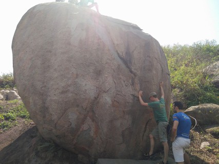 /57/a9/57a99b00d725913137b8c9e164e1d42389ef55ba) 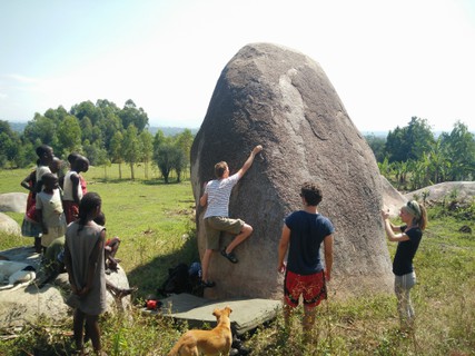 |
||||||||
| Route | Grade | Style | Selected ascents | |||||
|---|---|---|---|---|---|---|---|---|
| 1 |
★ Black Meadows
FA: Benoit Fabre, 10 Jan 2018 | {FB} 6B | 4m | |||||
| 2 | ★ Si tu rip tu rap | {FB} 5C | 6m | |||||
| 3 | Fish finger | {FB} 5A | 4m | |||||
1.16. Nagongera I 0 routes in Boulder
description
Bouldering site
approach
Parking at the school
1.17. Nagongera II 2 routes in Boulder
- Summary:
-
All Bouldering
Lat / Long: 0.784734, 34.028156
description
You can park on the side of the road. The owner and basically everyone around is very friendly. If you see anyone, please introduce yourself. It is private !
/eb/eb/ebeb382dec0e0a2088f2173af0cc37b5598ab06c) 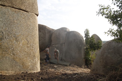 |
||||||||
| Route | Grade | Style | Selected ascents | |||||
|---|---|---|---|---|---|---|---|---|
| 1 |
★★★ Bongo Bong
FA: Benoit Fabre | 6m | ||||||
| 2 | Tchongo start | {FB} 5A | 2m | |||||
1.18. Fang Fang 1 route in Crag
- Summary:
-
All Sport climbing
Lat / Long: 1.338616, 34.318481
description
This little tower of rock just of the main road to Sipi Falls has some good climbing potential. A couple bolts have been added to get climbers started. With some development a nice variety of climbs could work for kids and advanced climbers alike.
This crag needs to be properly bolted and developed. The existing hardware is substandard. You can actually see the bolts/mallion from your car on the main road. Chema, and especially Sipi, have much better climbing, so give this a miss unless you wish to explore and potentially develop this rock.
access issues
Access has not been formally negotiated, but upon several visits no issues have arisen. So far, access has been free.
approach
Park just up the road from the tower and walk down through the field.
where to stay
Sipi and Mbale are nearby. Camping could surely be arranged on or near the site.
history
Some poor galvanized bolts were installed prior to 2015. Exact date unknown.
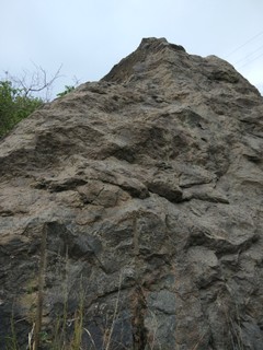 |
||||||||
| Route | Grade | Style | Selected ascents | |||||
|---|---|---|---|---|---|---|---|---|
| 1 | Normal Route | 10 | 10m, 3 | |||||
1.19. Sipi Main Wall 15 routes in Crag
- Summary:
-
All Sport climbing
Lat / Long: 1.335653, 34.375043
summary
The best routes in UG were put in here by grant-funded Italians in 2002. All hardware is glue-in. Unfortunately all lower offs are only single bolts connected by a dodgy handline at the top.
description
There are 15 sport routes, mostly around 8-10m. One 28m route exists. The belay area is comfortable and partly sheltered from rain.
access issues
Rob's Rolling Rock wrongly claims ownership of this land. There is a long history of harassment and attacks against climbers here. Rob has been arrested, fined, but later released to continue to intimidate climbers into giving him money to climb here. The original bolting team has not intervened in years with this conflict. Their intention was to allow multiple locals to work the crag and benefit from the proceeds.
If you wish to climb here, you should stop by the Sipi Police to let your intentions be known. Be specific with the times and dates you plan to climb and ask for protection from Rob. In these cases, you should be fine. Showing up unannounced will incur harassment and demands for payment.
Rob does not own the land or have any legal right to it. The police have requested proof that he owns the land on numerous occasions, which he has failed to provide. Rob now enjoys a virtual monopoly here earned through years of dogged persistence.
If you wish to not involve the police, you can pay Rob a fee for climbing, or you can rent climbing gear from Rob in exchange for harassment-free climbing. Neither are recommended as the legality of the crag should be properly determined. Other's within the community have attempted to break into this monopoly, but also suffered Rob's wrath. Rob has been known to rent old, damaged and substandard equipment like tattered ropes and bent carabiners.
approach
There are two options on the approach. From Sipi town, you can hike down the community trail to the farms below following the trail and switchbacks to the crag. Alternatively, you can abseil into this crag, but this will require a hike out. From Moses Campsite, you can find bolts/hangers from which to rap down. You'll need a 70m rope for this as the belay area is 33-34m below.
where to stay
There are lots of options in Sipi Falls. Sipi River Lodge is an excellent, upscale option. Camping directly at the top of the crag is cheap, with amazing views (Moses Campsite), but their food/service is quite slow and frustrating. Others stay at Crow's Nest, Lacam Lodge, or Noah's Arc, which are all okay and nearby.
ethic
This is a fully developed crag that should be free to all. Please don't pay Rob as this money only fuels the ill-gotten climbing monopoly on this crag.
history
Bolted in 2002, this was the second bolted crag in Uganda after Insita Rock. Insita has now been updated/retrofitted, so Sipi has the oldest hardware in the country but should last for many years to come. The single bolt anchors should be retrofitted with backup bolts.
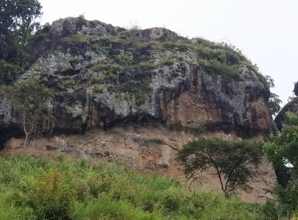 |
||||||||
| Route | Grade | Style | Selected ascents | |||||
|---|---|---|---|---|---|---|---|---|
| 1 |
Yellow Route
This is the farthest left route and does not connect to the hand line that connects the top out of most routes at this crag. | 17 | 6m, 3 | |||||
| 2 | Easy Peasy Lemon Squeezy | 17 | 7m, 5 | |||||
| 3 | ★ You Can Do It With Your Back | 20 | 8m, 5 | |||||
| 4 | ★★ Friends Remain Friends | 20 | 8m, 5 | |||||
| 5 | Return of the Wasps | 21 | 8m, 5 | |||||
| 6 | The Tallest Ralf | 20 | 9m, 6 | |||||
| 7 | ★★ Acacia Tree (Left Option) | 22 | 9m, 6 | |||||
| 8 | Acacia Tree (Right Option) | 22 | 10m, 7 | |||||
| 9 |
Banana Tree
This route is also disconnected from the hand line at the top. | 20 | 10m, 6 | |||||
| 10 | ★★ Mosc Swallow (short version) | 22 | 10m, 6 | |||||
| 11 |
Mosc Swallow (long version
Take a 60m rope to abseil off this or take a crazy, dirty free climb to Moses campground above. Just continue from Mosc Swallow for the full route. | 24 | 28m, 12 | |||||
| 12 | Sipi Gorge | 21 | 10m, 6 | |||||
| 13 | Hard Rock | 21 | 10m, 6 | |||||
| 14 | ★★★ African Rock Martin | 20 | 10m, 5 | |||||
| 15 | ★★★ Waiting for Jacob | 20 | 10m, 5 | |||||
1.20. Chema 7 routes in Crag
- Summary:
-
Sport climbing and Top roping
Lat / Long: 1.359946, 34.385964
summary
An alternative to getting harassed at the Sipi's main crag, the routes aren't as good, but still worth a trip, especially if looking for some easier routes and want the option to only tope rope.
description
Chema is a small crag located amongst beautiful farms, friendly people and virgin rock. The rock quality is poorer, which is probably why it hasn't been climbed or developed further. If you don't want to lead climb, you can scramble to access the belay chains and setup top-ropes on all the routes except Friends Remain Friends, which requires a rap in to setup.
There are seven bolted routes for top rope, four of which are bolted for lead climbing. The six lead climbs are only 10m, one top rope climb is 25m. Grades range from 17-25. Rock is conglomerate, loose and poor quality. View is amazing. No toilets or showers in this bush, but locals have pit latrines you can use. Trad climbing in this area does not look possible as rocks are mostly slab and quality is generally poor for pro.
access issues
Park at the general store in Chema run by Colin. Access is free. Parking is 3k per car. Consider hiring someone at the general store to guide you back to the crag for another 2k. It is a bit hard to find your way through the maze of local farms and houses and paying a few shillings for parking and guidance on the approach can go a long way with in positive relations with the local community.
approach
Head out of Sipi Falls. You’ll pass Chebonet and then arrive at the small town of Chema just less than ten minutes from Sipi's center. Park on the left at the general store operated by Colin: 0758 985 619.
1.35916667, 34.38916667 Colin’s shop sells bread, some produce, and water as well as other food/snacks climbers might find useful. If you want to hire a guide contact Backson 0705 528 981 or Peter: 0779 971 682. Free access for climbers to the rock has been promised by both Peter and Backson in cooperation with Sipi River Lodge (unofficial). Some small donation to the local community would be appreciated, but don’t feel obligated. Backson and Peter run a 83 meter abseil nearby for about 50 USD, but they are also climbers and they know the area and can help with local access should anyone try to prevent you from climbing. Hike down into the valley from the road past the coffee factory, which smells fantastic, and down the to the falls. Head right to the rock once you reach the falls. Colin or one of the guides can show you the way. In total, the hike from your car to the crag is about 15 mins or so. Depending on the trail you take, the last 100m is a very steep scramble down to the rock.
Coordinates of the belay area are: 1.3601077,34.383892. There are numerous ways to get to the belay area. Best pay someone 2k to walk you back. Have a friendly chat and try to keep up good relations with the local community.
where to stay
You can camp near the crag by asking locals for permission and paying a small fee. Or, stay in Sipi Falls which has lots of options.
ethic
Access is free to climbers, but this depends on climbers supporting the local community as much as possible. So, buy local, stay local, support the local economy as much as possible.
history
This was bolted in July 2015 as an alternative to the tension at Sipi's main wall.
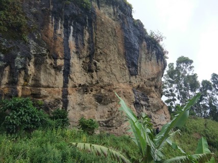 |
||||||||
| Route | Grade | Style | Selected ascents | |||||
|---|---|---|---|---|---|---|---|---|
| 1 |
★ Waiting for Matt
FA: Pierre Gay Perret | 21 | 10m | |||||
| 2 |
★ Climbing Goat
FA: Pierre Gay Perret | 20 | 9m, 4 | |||||
| 3 |
★ Friends Remain Friends
You must build and anchor above the cliff, rap over the side and swing in to access this chain to set the top rope for Friends Remain Friends. FA: Pierre Gay Perret | 25 | 25m | |||||
| 4 |
Milk Tree
FA: Pierre Gay Perret | 17 | 9m, 4 | |||||
| 5 |
★ Head's Up
FA: Pierre Gay Perret | 20 | 9m, 4 | |||||
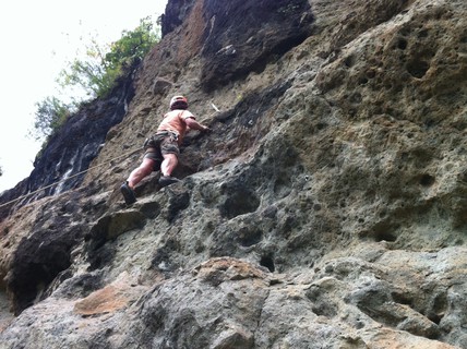 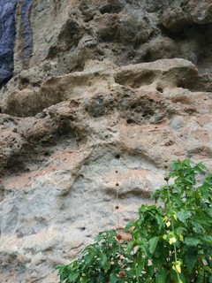 |
||||||||
| Route | Grade | Style | Selected ascents | |||||
| 6 |
★ Chebonet Gorge
FA: Matt Battani | 17 | 9m, 4 | |||||
| 7 |
★★ Roof Practice
FA: Matt Battani | 20 | 9m | |||||
1.21. Mary's Rock 1 route in Crag
- Summary:
-
All Trad climbing
Lat / Long: 1.863083, 34.635121
summary
Loads of rock in this region, but mostly poor quality/soft stuff. Nothing bolted, so carefully place your trad pro.
description
The drive between Namalu and Nakapiripirit takes you quite close to some nice looking rock. A very short walk from the road will let you put your hands on the rock. We have tested numerous rocks along this road and always opted to move on after little climbing because the rock is too brittle to climb on. Trusting protection in such rock is unlikely and flakes and jugs will come up right in your hand.
Consider hiking Mt. Kadam while here. It is a great hike and a nice alternative to the dodgy rock climbing in the area.
There is a good climb rated very difficult up a crack past a large tree called Waiting on Amanda. Park your car here and hike up to the face. Climbs are about 20m. Hike around to the top looked possible, but we didn’t bother as we just abseiled down. Locals are very curious and don’t seem familiar with climbing.
access issues
Free and unrestricted. We have had a warm welcome in the past and not been asked to pay for climbing.
approach
Drive out of Nakapiripirit towards Namalu. There are two roads, take the left option. That road winds closest to Mount Kadam. There are many impressive rocks near the road. Drive for 20 minutes or so and you’ll see several large boulders on your left and right. You’ll also see a modest face with features and cracks good for climbing on your upper left hand side. The face has some trees and a few thorn bushes, but it is generally clean and good rock for pro, albeit softer than ideal.
where to stay
Hill View Guest House in Nakapiripirit knows/welcomes climbers and hikers.
ethic
As climbing here is not established, please strive to build good relations for future climbers and hikers.
history
First climbed in June 2016 and not revisited as other sites in Uganda have better rock.
| Route | Grade | Style | Selected ascents | |||
|---|---|---|---|---|---|---|
| 1 |
★ Waiting on Amanda
FFA: Matt Battani, 10 Jun 2016 | 10 | 20m | |||
1.22. Alekilek 0 routes in Crag
summary
A gorgeous rock of great quality that has rarely been climbed, but has much potential for new lines and FAs.
description
There is a nice hike/scramble to the top of this one, which doesn't look possible upon first approach. You can park near the rock and simply ask the locals for a guide up to the top. In any case, you should take a local with you and pay them a fair wage to ensure warm/friendly and smooth relations with the local community.
Some of the lines on Alekilek look hard to protect with trad gear. A few bolts would help open this up for climbing.
Mt. Napak is just a couple kilometers away and a really nice 1-2 day hike.
In rainy season, consider taking pangas as the trails aren't well used/maintained. Better to visit during dry season.
access issues
Free and unrestricted, but take a local guide along and pay them a day's wage.
approach
Alekilek can be seen from the Iriri trading center. You can drive up quite near to the rock and negotiate parking and hire a guide from anywhere near this rock.
You can hike up and down from the top in about a half day.
where to stay
Camp at Pilas Primary School. The local town of Iriri didn't seem to have a guest house. Soroti was about an hour away.
ethic
Please establish nice relations with the local community for future climbers and hikers.
history
First Ascent by R.C. Smart and A.F. Trendall in 1960. Since then, Alekilek has had very few ascents.
1.23. Moroto 0 routes in Area
summary
A gorgeous mountain for hiking. Sport climbing could be possible here if rock was cleaned and bolted.
description
I have tried three rock faces connected to the Mt Moroto system, one on the western side just a couple kilometers out of town, another on the northwest about 30 minutes out of town and a third on the very north quite close to the Kenyan border. The faces look impressive and some are quite high offering multi-pitch potential in numerous areas. However, like the area around Namalu on the fringes of the Mt Kadam system, the rock is poor quality. There are yellow, grey, and black streaks in the rock, each brittle. I have explored these rocks on several occasions only to be disappointed. The rock is no worse than the quality at Sipi Falls, but the crags at Sipi were cleaned and bolted. The same could be done in future years around Mt. Kadam (Mary's Rock) and Moroto. At the moment, with this poor rock quality, trad climbing just simply isn’t desirable or particularly safe, though many lines look promising through binoculars from the road, the hikes in tell a different story. I still hope to be proven wrong about the rocks around Kadam and Moroto, but given what I have seen and tested, doubt that will be the case.
access issues
Friendly local community. Free access. Loads of potential faces to climb.
where to stay
There are many hotels in Moroto Town. Look into Kara Tunga tours as well. Or stay at the Tapac Monastery.
ethic
Be sure to establish positive relations with all people you encounter.
history
This rock has never been climbed except by a few exploring climbers who bailed after a pitch or two. Mt. Moroto is hiked regularly (Imagit and Sokodek Peaks)
1.24. Kenny's Rock 2 routes in Crag
- Summary:
-
All Trad climbing
Lat / Long: 3.117658, 34.157898
summary
An excellent rock near Kotido. Lots of potential single pitch trad lines.
description
Once you’ve made it this far, you are really spoiled for choice! Leave Kotido for Kabong. Shortly after leaving town you will start to see many trad possibilities on your left and right. After driving out for about 30 mins, we turned back in favor of this rock: 03°06.941’N, 034°09.524’E (Kenny’s Rock)
Kenny’s Rock is only about 15 minutes from the center of Kotido. There are at least a dozen trad possibilities on this rock. It is very hard granite and excellent for pro. There are lots of cracks and big pockets. There are some great natural anchors so you could top rope some climbs if preferred. Careful of bees and hornets as there are many living in the pockets of this beautiful rock. If dry, you can drive right up to the base of the rock. Climbs vary from very difficult to hard very severe and probably much more. We didn’t have time to explore extensively. Climbs are about 25-40m.
Locals are very curious and don’t seem familiar with climbing. If you continue on the road all the way to Kabong and eventually to Kidepo NP, you will see lots of other trad climbs along the way. The quality and height tends to increase the further north you go all the way near Kidepo.
If you leave Kidepo via the Kitgum road, you will see very many impressive mountains and climbing cliffs along the way. This part of Uganda would take years to explore. Please explore and post. This area is amazing and almost nothing here has ever been climbed probably due to geographic isolation and also possibly due to years of past violence/instability. Thankfully, that is now in the past and this area is ripe for exploration.
access issues
Free and unrestricted. Locals always ask for money but climbers have not had to pay in the past.
approach
Hike up is easiest on the southeast side.
where to stay
Las Vegas Hotel: 0786403656. Clean rooms, great local food. Cheap. Order hours in advance or even the day before if possible. Las Vegas Coordinates: 2°59'50.0"N 34°06'27.2"E (it is a bit hard to find)
ethic
Please build positive relationships with the local people to help future climbers.
history
First climbed in 2016 and revisited in 2017.
/2d/35/2d356c52e37d67ee9fe905dde5c4a1a978381525) /4d/19/4d198048c1e6b3086c8c44a8200d3c8438e641eb) |
||||||||
| Route | Grade | Style | Selected ascents | |||||
|---|---|---|---|---|---|---|---|---|
| 1 |
★★ Thanks to Amanda
In the northwest corner there is a severe trad climb called “Thanks to Amanda”. You’ll start by scrambling up 2m to a small ledge. Then put in your first pro, shortly followed by two more pieces. Careful of the boulder on your left. It could be loose. After the boulder, the climb is straightforward and you’ll get a couple more pieces of pro in. The last 12m of the climb follows a positive incline with many excellent footholds, but scant chances to put in pro, so falls near the end could be very dangerous. You can abseil down off boulders at the top. This climb is about 22m. FFA: Matt Battani, 12 Jul 2016 | 13 | 22m | |||||
| 2 |
★★★ Up the Runnels
A unique combination of slab, open book, off width and crack climbing that requires a variety of skills and techniques. FA: Matt Battani, 12 Jul 2016 | 20 | 28m | |||||
1.25. Amiel 1 route in Crag
- Summary:
-
All Trad climbing
Lat / Long: 2.948984, 33.461135
summary
Uganda's most classic and iconic multipitch trad climb.
description
This easy trad climb is great for beginners. There is excellent pro and nice pitches all the way up. The biggest risk is probably getting lost on the rap down. The biggest annoyance is probably the hike in or the bushiness of the route.
Puff adders and scorpions call this place home, so watch out!
access issues
Free and unrestricted, though climbers always leave a gift behind to thank the community for the warm welcome.
approach
You can drive off the main road back through the village at the foot of Amiel several hundred meters. Have a local person direct you. From there, you'll need locals to help show you the path to the first pitch. The hike is 30-45 minutes and steep. It's bushy in rainy season and miserable when hot.
where to stay
Amiel is easily reachable from a guest house in Kalongo.
ethic
Over the years, climbers have built up a very solid relationship with the local community. Please work to keep this up for future climbers. Also, please don't bolt the trad routes here. Amiel has many other faces that could be bolted. Please ask the locals for their blessing in any bolting projects.
history
First Ascent: pitches 1-9 R.M. Bere and his D.C. (1931) Second Ascent: Anna and Henry Osmaston (April 1950). Amiel Osmaston was born later and named after this rock. Full Ascent: Henry Osmaston and Andrew Stuart (April 1959).
In recent years, Amiel gets climbed at least several times per year.
You can find several articles about Amiel from the old days via a simple internet search which provides some fun reading if you're planning a trip here.
Allegedly, the route's cracks and gullys providing hiding places for children during the LRA war. In any case, the local population know the start of the route very well. Some may even join you at the summit.
   |
||||||||
| Route | Grade | Style | Selected ascents | |||||
|---|---|---|---|---|---|---|---|---|
| 1 |
★★★ Northeast Butress
Have a local show you to the first pitch. In total, this climb is four pitches, though you could stretch it into three. There are plenty of bushes and trees along the way to protect your descent without needed to lose much tack. Follow the broken pillars and cracks up the northeast butress. Careful to rap down exactly as you ascended or you might find yourself in a sticky position. While you could do this in boots/shoes, climbing shoes make it much more enjoyable. We've left our boots waiting for us at the start of the first pitch on pasts climbs. Locals will look after them for you and haven't bothered our stuff in the past. FFA: R. M. Bere, 1931 | 13 | 150m, 4 | |||||
1.26. Mt. Oret 3 routes in Area
- Summary:
-
All Trad climbing
Lat / Long: 3.042472, 33.365925
summary
This huge, 500m tall rock on the edge of Kalongo in Agago District (Acholiland) has the best, highest, longest multi pitch trad climbing in all of Uganda.
description
This huge rock has many potential lines and an easy hike down following a service road that supplies the tiny military base on the top of the rock. As of 2018, only two lines (13 and 10 pitches) had been established.
During rainy season, or after any rain at all, these routes can be impassable. Mt. Oret dries out slowly and these routes in particular can take days to dry out after a rain.
access issues
Access is free and the local community is friendly. You may need to pay a few shillings to park near the rock and to have someone look after your car. Make sure to ask a local for permission and agree on a price beforehand if possible. We paid 2k for a day's parking. Once you reach the top of the rock, the soldiers might threaten to arrest you. So far, climbers have just been friendly with the soldiers, shared some stories, showed and explained our gear, shared a few snacks and laughs with the UPDF men on top of Oret and walked away without much hassle.
After the hike down, you can grab a boda boda to retrieve your car. After dark, locals might be drunk and therefore quite pushy for exorbitant parking fees. Possibly just park at your guest house and hike to the base or retrieve your car earlier in the daytime when folks are more likely to be reasonable.
approach
Park on the back side of the sprawling Kalongo Hospital complex as near to the rock as you can find, which is next to some huts. Hike up the bush to the base from there. There is no trail and it can be quite bushy and steep. Should take 30 mins or so.
Maybe wear long sleeves and pants on this one. The approach can be thorny and the rock is pretty sun exposed. You might see a snake or two along the approach and lower pitches.
where to stay
There are a number of guest houses in Kalongo. As there is huge potential for climbing in this part of Uganda, maybe negotiate to stay for a week or more.
We stayed in Kalongo town at the Lim Welo Guest House, which was 15k per night for non-self contained rooms and not including breakfast.
ethic
Very few climbers have enjoyed these rocks over the years, but the potential is immense. Please do climbers a favor and work to cultivate a positive image of climbers in this area.
history
Mt. Oret was first trad climbed in 2015 by Emmanuel Fredenthal and Luke Hodgkinson. Since then, a handful of climbers have summited this. The nearby rocks of Rwot and Amiel were first climbed in the late 50s and early 60s. However, the old guidebooks from 1962/3 and 1991 leave no mention of anyone climbing Mr. Oret or Kilibi.
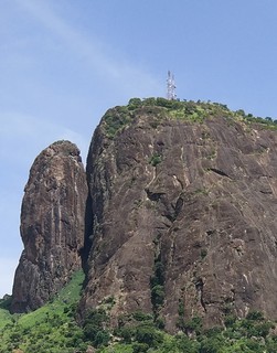 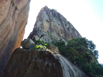 |
||||||||
| Route | Grade | Style | Selected ascents | |||||
|---|---|---|---|---|---|---|---|---|
| 1 |
★★★ Corporate Night
Description by E Freudenthal 2015 Update by M Battani Sept ‘17 The route climbs the northeast face of Mt. Oret/Kalongo, starting in the largest gully, then mostly straight up following cracks systems and easier but run out slabs to the top. Overall, it has really good and fairly sustained climbing, the rock is solid and only a few passages require you to battle with vegetation. We took about 8h for the climb and 1h for the descent. Be warned that the top slabs will be impassable if they are wet and backing off from them will be tricky/expensive. This rock can take days to dry out after heavy rains and this route follows a gulley which is one of the last places to dry. This is the description to the best of our recollection; there might some mistakes and better variations. From the path in the village behind the hospital fence, spot the large gully with a very tall, straight tree with white bark sticking out of it. Simply thrash your way through the high grass and boulders until you reach the bottom of the gully. The start of the route is about 30m left of the right hand wall of the gully, where a narrow black slab widens out into some bushes.
Descent: Head northwest across the summit to find the road down. You’ll probably meet Bosco, the military man stationed at the summit. Say hi from us and sign his book. He might give you citrus fruit. The descent takes ~1hr. FFA: Emmanuel F & L Hodgkinson, 30 Nov 2015 | 18 | 490m, 13 | |||||
| 2 |
★★ Zigzag
Be warned, the top slabs will be impassable if they are wet and backing off from them will be tricky/expensive. This rock can take days to dry out after heavy rains. 6-8 hours (the last three pitches are shared with Corporate Night) Take a normal rack plus large cams. We used Black Diamond #5 once and regularly used BD sizes 2-4. Some trees can be slung, so take plenty of slings. Take lots of alpine draws. We left micro nuts/cams behind and didn't need them. Take light walking shoes or sandals with you as the hike out takes about an hour. Hike up to the right of the huge and very prominent detached spire and between two trees towards a rib like feature. We started the climb between the trees going up the rib and over a hump. This entire climb is pretty sun exposed. Corporate night, which is 50-60m right of Zigzag, is a bit more shaded because there are more trees along that route.
Descent: Head across to the summit to find the road down. You’ll probably meet UPDF troops at the top. Say hi from us and sign the book. Those solders rotate out frequently and therefore have been surprised each time it has been climbed. They once threatened arrest. Smile and try to relax. Once they knew we were just climbers, they warmed and let us go. The descent takes ~1hr. FFA: Matt Battani, U Pitsch & W Rutowski, 20 Jun 2017 | 18 | 460m, 10 | |||||
| 3 |
★★ Spire
Walk up through the gully between Mt. Oret and the detached spire on the east side of Mt. Oret. This route is probably 100m west/left of Zigzag. Move up through the gully as far as you can scramble up to the first pitch. From there, you'll find protected climbing up two short pitches within 5m or so of the top of the spire. Note, this route is mostly on the southwest side of the spire itself, has good shade and is nearly in between the spire and Mt. Oret. We turned back about 5m from the summit. The climbing at the top was not very difficult, but would have been unprotected with serious consequences. So, the spire remains unclimbed. We asked people in Kalongo, checked online and went through the MCU archives. No recorded summit of this spire has yet taken place, so go and get this FA if you dare! We would have added a bolt or two to protect this climb, but unfortunately were without our bolting equipment on this trip. Next time! The grade and description above only rates how far we went and does not count the summit or lack of protection. The grade would have to go up and include an X for a full climb of this spire. FFA: Matt Battani & U Pitsch, 21 Jun 2017 | 16 | 100m, 3 | |||||
1.27. Paimol Rock 0 routes in Crag
summary
There is some single pitch trad and top rope potential here. Nothing is bolted, so take all your gear. This is an easier warm up before tackling Oret or Kilibi.
description
This is good quality, but unclimbed rock. It would probably need some cleaning and development. It is much shorter than other big walls nearby.
access issues
Access was granted freely without incident. Local community was friendly.
approach
From the parking, just hike towards the rock. There is no trail, so consider taking a panga.
where to stay
This can be easily reached from Kalongo.
ethic
Please build a positive image of climbers in this community.
history
This rock was first "discovered" and climbed in October 2016.
1.28. Akwang 0 routes in Area
summary
This unclimbed area has massive potential. Much of it looks to need bolts. There are several impressive vertical walls shaded most of the day. If developed, this could be a first class sport area.
description
Use the same parking areas as for Kilibi. Simply hike up towards the rocks and pick your line. Please explore and post.
Dry season visits are much preferable as trails and routes are less bushy.
access issues
I have visited the area 4-5 times and always been given free access by friendly local people. I'll pay 2k for parking on someone's land.
approach
Easy walk up.
where to stay
Easily reachable from a guest house in Kalongo. Camping nearby possible as well.
ethic
This area is "deep" in Uganda and doesn't see a lot of outside visitors. Please be conscientious in developing positive relationships with the local community to pave the way for future climbers.
history
No registered climbs so far. This area is not mentioned in the old climbing guidebooks from 1962/63 or 1991.
1.29. Kilibi 2 routes in Area
- Summary:
-
All Trad climbing
Lat / Long: 3.112686, 33.412518
summary
This shard looking tower is one of the most impressive and intimidating rocks you'll see anywhere in Uganda. There are two known routes to the top and potential for more.
description
Near the village of Akwang in the Paimol sub-area of Agago District, there is great climbing potential. We only climbed Kilibi Rock. (see Deep in the Village and Normal Route) A drive around the area to/from Kalongo will yield other impressive rocks and possible climbs. Mt. Kokil is next to Kilibi and looks hikeable. There may be a number of quality lines there and in the adjacent rocks . This area is very near the climbs of Amiel and Mt. Oret. About an hour’s drive will get you to Rwot and Loyoroit.
The map shows the Kilibi inside the shape in the west. The shape in the east shows the parking and the line on the map links the parking and the rock showing the approximate hike in.
access issues
Free and unrestricted. This area sees very little interaction with the outside world. It is like going back in time! People are very friendly. They ask for money. We usually give a small give gift like a bag of salt or rice.
approach
Drive through Paimol and then through Akwang. Just a couple hundred meters after Akwang, there is a easily missed left turn just before a bridge. You’ll need a 4WD because this turn goes down into a ditch and up to a very poor road. Follow that road as far as you can past the huts, trending to the right to Joseph’s house (3.11523, 33.42742). You’ll be about 200m off the main Akwang road when you park. You’ll be unable to see Kilibi from here, but tell locals you want Kilibi and they will all point you in the right direction. A couple hundred meters past the parking at Joseph’s you’ll see Kilibi.
If unsure, you can ask around for Joseph and should ask permission to park there. He's a very nice/friendly guy.
If you don't have a strong car, or prefer a better road, you could also park at Akwang on the main road and walk in. The hike from Joseph's is about 40 mins. Locals can show you the way or follow your gps or the map.
where to stay
This is easily reachable from guest houses in Kalongo.
ethic
Nobody lives at the foot of this rock, so nobody is likely to ask money for climbing it. Locals live a few hundred meters away. This also means that trails run out a bit near Kilibi. Some bushwhacking is necessary to reach the rock itself in rainy season, however the approach is less bushy than Amiel and Mt. Oret. Please be friendly and kind to the local people. They have let us climb in the past but as this is their community, please play by their rules.
history
I first saw this rock in 2016 and hunted around for the best approach. We returned and climbed two routes on Kilibi in 2017. Deep in the Village has only been climbed once. There is no mentioned of this rock in either the 1962/63 guidebook or the 1991 guidebook. It is also not mentioned on any other climbing websites.
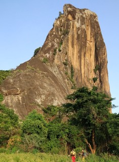 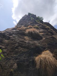 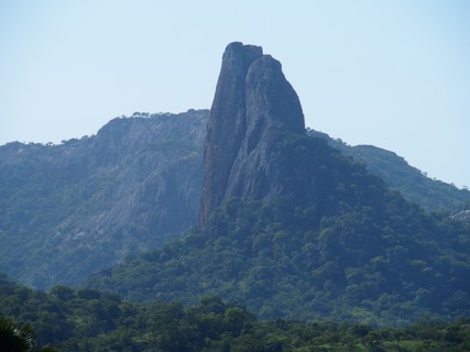 |
||||||||
| Route | Grade | Style | Selected ascents | |||||
|---|---|---|---|---|---|---|---|---|
| 1 |
★★★ Deep in the Village
Deep in the village 20 (Descrition by M Battani and U Pitsch) (approximately N3.11206° E33.40837°) Get up early for this one as it is a full day with the drive from Kalongo, parking, hiking, rapping, and getting home. We left our guest house in Kalongo at 6:15am. You may want to carry your boots/shoes on the climb because the descent is on the opposite side of the climb. We hiked barefoot back to our gear at the base of the first pitch. It hurt. The route starts on the north east side of Kilibi Rock. You can see a big ramp leading up Kilibi. The first pitch starts up this ramp. Aim for the large flake about 60m up for your first stance.
FFA: Matt Battani, U Pitsch & W Rutowski, 23 Jun 2017 | 20 PROT:X | 280m, 6 | |||||
| 2 |
★ Normal Route
Description by Uwe Pitsch The route starts on the west side of Kilibi Rock.
FFA: Uwe Pitsch, 22 Jun 2017 | 14 | 120m, 3 | |||||
1.30. Rwot 2 routes in Area
- Summary:
-
All Trad climbing
Lat / Long: 2.790550, 33.693251
summary
A 600m goliath of rock. Rarely climbed due to lack of protected lines and bushiness in the Great Gully route.
description
Descriptions of the Great Gully Route can be found in the 1962/63 and 1991 guidebooks. As I haven't climbed this route, only due to the overgrowth of the line, I won't include many details here. Contact me if you'd like the old descriptions. You may also be able to find descriptions online through mcu.ug.
This should be done during dry season, preferably towards the end when bush is at its yearly minimum.
Baboons live here so be aware and especially mind your possessions.
access issues
No access issues to report. Upon hiking and driving around Rwot, we found the local community friendly and open to our climbing exploration.
approach
I did not identify the best approach, however there is a village very near Rwot where you can park and camp. This village is opposite the Great Gully, so an alternative approach might be better.
where to stay
You can reach this from Kalongo, or camp nearby.
ethic
Please build friendly relations with the local community to pave the way for future climbers. It would be great to get some bolts on this rock.
history
First climbed in 1958, Rwot has rarely been climbed since due to lack or routes and the over-vegetated gully.
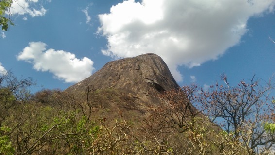 |
||||||||
| Route | Grade | Style | Selected ascents | |||||
|---|---|---|---|---|---|---|---|---|
| 1 |
★★★ Great Gully
FFA: Fritz Moravec, Stefan Ortmann, Josef Pfeffer & Karl Prein, 1958 | 14 | 350m, 8 | |||||
| 2 |
Hurley's Horror
FFA: George Hurley & Jean Hurley, 1963 | 15 | 350m, 8 | |||||
1.31. Loyoroit 1 route in Crag
- Summary:
-
All Trad climbing
Lat / Long: 2.816254, 33.744643
summary
Lots of potential at this 1-2 pitch trad crag nearby to Rwot, Amiel, Mt. Oret, Paimol, Akwang, and Kilibi. This is trad climbing central in UG!
description
Description by L. Hodgkinson
The crag is a smallish broken buttress, around 100m high on the north side of Lira road between Alerek and Loyoroit, about 5k past the goliath Rwot. There is good potential for 20-30 new routes of varying difficulties between 20-100m. It’s ideal for a good warm-up or warm down for the all-day climbs of Rwot, Kilibi, Amiel or Mt. Oret (Kalongo). The rock is mainly solid and the descent is easy. You’ll also see other potential in the area that we haven’t had time to explore.
access issues
No issues to report. Did not pay local community. Only climbed once.
approach
Access is via a quick off-road excursion in high grass between trees towards the rock (mainly to hide your vehicle and prevent a commotion) and then a five-minute walk/scramble to the face.
where to stay
Reachable from a guesthouse in Kalongo
ethic
Please strive to build positive relations with the local community to help future climbers.
history
First ascent was L. Hodgkinson, D. Willette and J. Foye Dec 2015.
| Route | Grade | Style | Selected ascents | |||||
|---|---|---|---|---|---|---|---|---|
| 1 |
★★ Anopheles
Description by L. Hodgkinson Pitch 1 45m (15) Start at the centre of the buttress beneath a tree growing ~4m up the rock. Move easily up a broken wall to the tree and then trend left up runnels and shallow cracks to the large break under an overhanging boulder. Watch out for bees whilst traversing the ledge to the right, then thrutch up the flared chimney onto a large landing followed by a short scramble up a vegetated gulley to a large tree belay. Pitch 2 50m (10) Move left out onto the edge of the ridge and take a direct, airy scramble up and over the knife-edge until it flattens out just before the summit. Take a seated or standing belay some point back from the ridge, unless your rope is longer than 50m in which case you might make it to the boulders. You can un-rope and scramble to the very top from here. Descent is a 15-minute walk down along the foot of the west face of the buttress. FFA: L. Hodgkinson, D. Willette & J. Foye, Dec 2015 | 15 | 95m, 2 | |||||
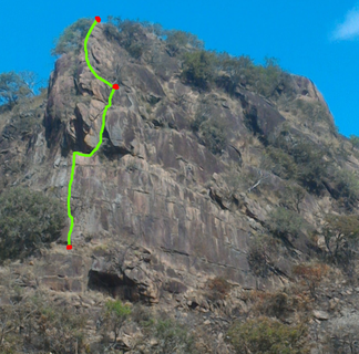 |
||||||||
1.32. Naita Rock 1 route in Crag
- Summary:
-
All Trad climbing
Lat / Long: 3.566277, 34.142466
summary
This incredible granite plug is a bit hard to reach, but once you are there, you'll be happy you came. Only trad climbed once, so a chance for second ascent and new lines abound.
description
About a 20 minute drive outside of Kaabong is the rock of Naita. We climbed it in four pitches, though it could have been done in less (see below). There was no evidence that anyone had climbed it before. We saw no pitons or tack at the top or anywhere along the way. Locals also told us that nobody has ever been on top. The top of pitch two and part of pitch three are accessible by a difficult walk and scramble up a chimney, so a local boy or two may join you along this section. One joined us, collected firewood and threw it down past us as we climbed. You can walk down from pitch two or three if you decide to turn around, though the hardest pitch is the first pitch, so if you send that one, you might as well go for the summit. We did this in rainy season and it wasn’t too hot or too bushy.
access issues
Free and unrestricted however expect to be asked for money. Only climbed once so access negotiations would be ongoing. We gave a small gift of rice.
The local community was very friendly, but unlike some other places in Uganda, it felt as though this community had experienced very few outside visitors. They greeted us with a mixture of excitement, expectation and fear. As leaving, we gifted some dried beans to a local woman and gave two men a lift to Kaabong. We were repeatedly asked for money, but didn’t give any. We departed with mostly good feelings all the way around, though a couple folks were clearly disappointed with our refusal to give cash. However, a local man assured us that we would be welcome back to climb again.
approach
Naita Rock, Village of Yorun outside of Kaabong, Lat 3.56607 Lon 34.14223
Drive and walk up: Leave Kaabong on the road to Kidepo, just outside of town, turn right by small mountain with the large radio tower, continue straight for awhile and then turn right. You will be able to see Naita Rock on your right. Decent village roads get you about 200m from the rock. There is an impressive local settlement manyatta called Yorun at the base of the rock, so there are trails all around the rock making scouting and access quite easy.
where to stay
There is a guest house in Kaabong or camp nearby, with local permission, of course.
ethic
This community seems to have encountered very little outside visitors. Be very careful not to alarm or quarrel with the locals. Naita and Yorun is their world. Be on your best behavior as very little is known about this community.
I took photos of local children and an aerial view into the manyatta from the top of Naita. I showed these photos to many local people who were nothing short of amazed.
history
First Ascent by U Pitsche and M Battani July 16th 2017
On the Geology: These (Naita and the row of connected rocks) appear to be plutons (plutonic stocks or diapirs of some sort to be more precise), which are igneous intrusions. Had they fully extruded through the ground from magmatic activity then they would have been volcanic, but these stocks form from magma welling up and cooling beneath the surface and their linkage may be expressed along what are called dikes which have left their expression as the long linear boulder remains between the stocks and which form from cooled magmas forming vertical walls along fractures. Erosion has brought the stocks to their current prominence (looks to be granite), which makes for great climbing. Volcanic rocks tend to not be very good for climbing since they tend to weather quickly into clay mostly, whereas granite is a crystalline matrix, which has lots of the durable mineral quartz. For more information you can Google plutons, plutonic diapers, and batholiths, which are related and are world known for great rock climbing. –Matt McCullough Geologist
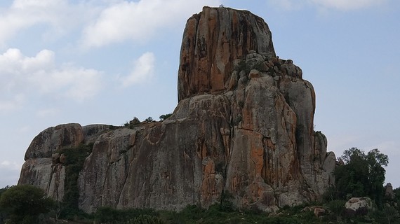 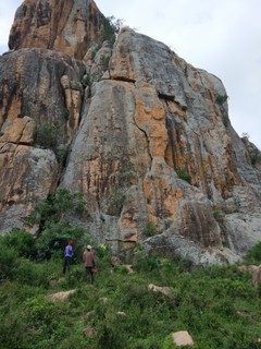 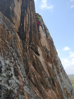 |
||||||||
| Route | Grade | Style | Selected ascents | |||||
|---|---|---|---|---|---|---|---|---|
| 1 |
★★ A Peak in the Keep
Take all your big cams for this one.
Rappelling off: (one pitch) There is very old bush with a large trunk near the east face. We left a piece of tack behind and rapped of there. About a 25m rappel gets you to the enormous platform on the side of the manyatta, from which you can hike/scramble down. We moved about ten large flakes that could have fallen during the rappel as they sat near or under the rope, so be very careful with these. You should see the path we cleared. We saw a 1m coppery brown snake and some lizards up there. Several large owls make their home on this rock as well. There is lots to see from this summit. Check out the manyatta. The view inside is incredible. Also, you can see all the other plutons in Naita's row. There is much potential climbing in this "rim". Hike down: You’ll see a narrow chimney from which we could squeeze down, but you could also rap down to the ground. From there, the path moves right along the edge of the main rock. Finally, scramble down a couple of ledges until you reach solid ground. Well done, you have made it back. FFA: Matt Battani & U Pitsch, 16 Jul 2017 | 18 | 90m, 4 | |||||
1.33. Patiko 3 routes in Crag
- Summary:
-
All Top roping
Lat / Long: 3.024457, 32.315556
summary
A beautiful rock with lots of sport potential. Unfortunately, only top rope as of December 2017.
description
Excellent slab climbing near Gulu. As of December 2017, nothing had been bolted. There is no trad potential, however, using slings and large cams, a number of excellent routes can be setup for top rope. If a few belay chains could be installed, lots of great climbing could be enjoyed at this site. Several dozen routes look possible for top rope or sport climbing if this crag gets bolted. The three routes listed here, Going Up on Nothing, Normal Route, and Swing Around all uses the same anchor. Directionals help keep you on route in case of a fall.
access issues
Local reception has been friendly and without incident. Climbers from Gulu, Kampala, and The Recreation Project have reported no access issues or required payment/fees.
approach
This is the tallest/biggest rock you can see around. It is visible from Patiko and from Sir Samuel Baker's Fort. The best known climbing is on the highest/most obvious rock.
From Gulu, the drive is about 55 kms. Take the road to Patiko, then follow this pin and park here: https://goo.gl/maps/xHwk8KcoMLu
The last couple hundred meters of the drive to the parking is on a rough secondary/dirt/murram road. Alternatively, you could easily park out on the main road and walk in. Even walking from Patiko town would be easy enough.
From the parking area at the pin, walk up the very large exposed ramp of rock. At the top of the ramp, trend left towards the taller rocks and cliffs. This is the climbing area.
where to stay
Gulu is just an hour away. The Palm Garden Resort has secure parking, food, and self-contained rooms for 36k. Bush camping is certainly possible nearby, just ask the locals. Patiko probably has a guest house. Adjumani is also an option, though a bit further away.
ethic
Very little climbing goes on here although this is excellent rock. The Recreation Project in Gulu sometimes uses this slab for abseiling with kids. Check out their website and contact them for more details. As of December 2017, they were keen to have some lower offs/belay points bolted on the rock. With a little asking around and confirmation, permission to bolt might easily be granted. It isn't clear who would need to "permit" bolting but good to ask around anyway.
history
The Recreation Project has used this for a few years. No other climbing history on this rock has been documented.
1.33.1. Patiko's Main Wall 3 routes in Sector
- Summary:
-
Lat / Long: 3.023190, 32.314689
description
The tallest routes can be found here.
| Route | Grade | Style | Selected ascents | |||
|---|---|---|---|---|---|---|
| 1 |
★★ Going Up on Nothing
Using the crack at the top of the rock, you can setup an anchor with large cams Black Diamond sizes 2-6 work. This is a bit left of the crack and about 2m left of the normal route. Set: Uwe Pitch, 19 Jul 2017 FA: Uwe Pitch, 19 Jul 2017 | 23 | 25m | |||
| 2 |
Normal Route
This nice slab climb starts directly below the crack. You won't need a directional for this route. After building the anchor, abseil down and follow the rope back up to the top. Set: Matt Battani, 17 Jul 2017 FA: Matt Battani, 17 Jul 2017 | 19 | 25m | |||
| 3 |
★★ Swing Around
Abseil down from the anchor. From the bottom, move right and on top of the two boulders. There seems to be no move from here, so sit and swing on the rope around to the right. This is the NW corner of the rock. Get established on the rock and from there and make your way up. After this tricky start, it is a nice route. Set: Uwe Pitch, 17 Jul 2017 FA: Uwe Pitch, 17 Jul 2017 | 18 | 25m | |||
1.34. Mt. Wati 1 route in Area
- Summary:
-
All Trad climbing
Lat / Long: 3.230320, 31.030710
summary
A beautiful, yet undeveloped area well worth the visit if you are in this part of Uganda.
description
The largest mountain in the region of West Nile, Mt. Wati offers some great hiking and climbing potential. Nothing is bolted as of 2018, but a number of features and cracks offer protected trad climbing. Make sure to try this in dry season as some of the rock stays wet/slimy in rainy season.
Lots of crack climbing here. Rock quality is excellent. Cracks are often full of dirt and grass. Generally lots of good placements for pro.
access issues
The road to the base of Mt. Wati is pretty terrible, so plan accordingly. We used a Land Rover Defender and the local population said they had not seen cars in a couple weeks. The main roads were good most of the way, but the last km or so to the school was pretty bad.
Free and unrestricted access. Parking is nearby at Mt. Wati Primary School. Pay some shillings to park. 2-5k should be fine.
approach
From the school, the approach is about 20-30 mins uphill along village trails. Many locals are keen to show you the way and even climb or hike with you.
where to stay
Arua is about an hour away. Otherwise, camping at the school is possible. If you pay the headmaster a few shillings, he will let you pitch a tent on the school's grounds.
ethic
Mt. Wati has only been rock climbed once. Hikers from Arua visit here and summit at least a few times per year. The local community will certainly be happy to see you if you give out some gifts or cash. This isn't necessary and not particularly helpful to future climbers as it sets a bad precedent. However, if you employ any guide or porter, or camp on someone's land, you should expect to negotiate and pay a fair price.
history
No known history of climbers on this rock. It is not mentioned in any of the previous guidebooks or anywhere online.
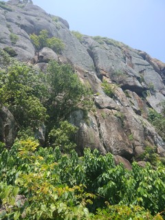 |
||||||||
| Route | Grade | Style | Selected ascents | |||||
|---|---|---|---|---|---|---|---|---|
| 1 |
★★ Uwe's Route
Follow the somewhat off-width crack up, trending left towards a comfortable ledge with a large three easily slung for a rap off. We used large and small cams on this pitch. The crack demanded cams rather than nuts. We explored to the left and right of this ledge, but found the way up to the summit of Wati too difficult. It was wet/slimy/mossy in July, so we gave up. Climbing this in dry season, for example December or January, might be much easier. We estimated the full climb to the summit of Mt. Wati might be 2-4 pitches. FFA: Matt Battani & U Pitsch, 22 Jul 2017 | 19 | 40m | |||||
1.35. Cha's Lagoon 0 routes in Sector
description
The sector is a cliff of about 12-15m high and about 50m wide. It is not cleaned (the middle part has loose rocks while the right side is more clean) nor bolted, and most of the cliff is above a waterhole. It used to be part of the current quarry located next to the cliff. It seems to have nice potential for routes of pretty various grades. The surrounding area though not much explored could be potentially suitable for more sport climbing sectors or bouldering.
approach
The cliff is located at the foot of Ngetta rock. From Lira town take the direction of Kitgum, then branch on the right side few kilometers after town, at the petrol station, to go to Ngetta rock. You can park your car either at the quarry wether continue following road/footpath to reach the top of the cliff.
descent notes
Be aware that the place has no anchor on top (if successfully tested, a car's hook can be used as such). Moreover, due to the presence of water (which is there likely most of the year), belaying from the ground is not possible for the central part of the cliff. Consequently you'll need to think about your escape plan beforehand in case you'd fail to reach the top (for instance, belaying from the top and considering a little swim as an escape plan, or ascending the rope, etc).
history
The sector has no known history of climbing. Legal or more formal access to it would need further thinking for bolting/cleaning the rock, but it fairly seems it would be granted. MCU's members can get in touch with Rachel Amai (0785699205) or Steven Amai (0772326949) to be showed around and eventually to help with establishing more formal access to the sector.