Use this Region Guide to easily find and compare Crags.
Table of contents
- 1.
Central Tablelands
7773 in Region
-
1.1.
Blue Mountains 7093 in Area
- 1.1.1. North Lower Blue Mountains 101 in Area
- 1.1.2. Lower Blue Mountains 691 in Crag
- 1.1.3. Mid mountains 11 in Unknown
- 1.1.4. Kings Tableland 18 in Crag
- 1.1.5. Leura 207 in Crag
- 1.1.6. Katoomba Area 872 in Crag
- 1.1.7. Medlow Bath 292 in Crag
- 1.1.8. Blackheath Area 1150 in Crag
- 1.1.9. Mount Victoria Area 1898 in Crag
- 1.1.10. Bells Line of Road & Chifley Rd 1083 in Crag
- 1.1.11. Newnes Plateau 484 in Area
- 1.1.12. Mt Blaxland 6 in Crag
- 1.1.13. Uber Land 20 in Crag
- 1.1.14. the lost city of clywdd 6 in Area
- 1.1.15. Cox's River Bouldering 78 in Crag
- 1.1.16. The Overlook 36 in Crag
- 1.1.17. Black Site Crags 45 in Area
- 1.1.18. Lithgow Valley 62 in Area
- 1.1.19. Summer Crag 33 in Crag
-
1.2.
Wolgan Valley 464 in Crag
- 1.2.1. Eldorado 10 in Area
- 1.2.2. Coal Mines Cliff 48 in Cliff
- 1.2.3. Old Baldy 104 in Area
- 1.2.4. Petrie's Gully 25 in Area
- 1.2.5. Wilderness Areas 33 in Area
- 1.2.6. Exploding Galaxies 29 in Area
- 1.2.7. Coke Ovens Cliff 121 in Cliff
- 1.2.8. Coke Ovens Upper 10 in Area
- 1.2.9. Desperado Walls 6 in Area
- 1.2.10. Capertee Creek Cliffs 31 in Area
- 1.2.11. The Point / Landslide Area 8 in Area
- 1.2.12. The Badlands 39 in Crag
-
1.3.
Capertee Valley 11 in Area
- 1.3.1. Ganguddy-Dunns Swamp 9 in Crag
- 1.3.2. Genowlan Mountain Walking Track 2 in Area
-
1.4.
Evans Crown / Tarana 136 in Crag
- 1.4.1. Deckout Buttress 32 in Area
- 1.4.2. Googolplex Crag 34 in Area
- 1.4.3. Crown Buttress 49 in Area
- 1.4.4. The Hamburger Stand 1 in Area
- 1.4.5. The Devils Agates 3 in Area
- 1.4.6. The West Side Ridge 16 in Area
- 1.4.7. The Northern Slabs 1 in Area
-
1.5.
Oberon 13 in Area
- 1.5.1. Obe Won Kanobi Boulders 13 in Area
-
1.6.
Mt Canobolas 56 in Crag
- 1.6.1. Pine Rocks 42 in Crag
- 1.6.2. Lunar Crag 7 in Cliff
- 1.6.3. Little Pines 4 in Cliff
- 1.6.4. Pinnacle 3 in Area
- 1.6.5. Geometric Cliff 0 in Cliff
- 1.6.6. The Walls 0 in Area
-
1.1.
Blue Mountains 7093 in Area
1. Central Tablelands 7,773 routes in Region
- Summary:
-
Sport climbing, Trad climbing and other styles
Lat / Long: -33.051810, 149.870332
access issues
If you have benefited from climbing infrastructure in NSW, please consider making a donation towards maintenance costs. The Sydney Rockclimbing Club Rebolting Fund finances the replacement of old bolts on existing climbs and the maintenance of other hardware such as fixed ropes and anchors. The SRC purchases hardware, such as bolts and glue, and distributes them to volunteer rebolters across the state of New South Wales. For more information, including donation details, visit https://sydneyrockies.org.au/rebolting/
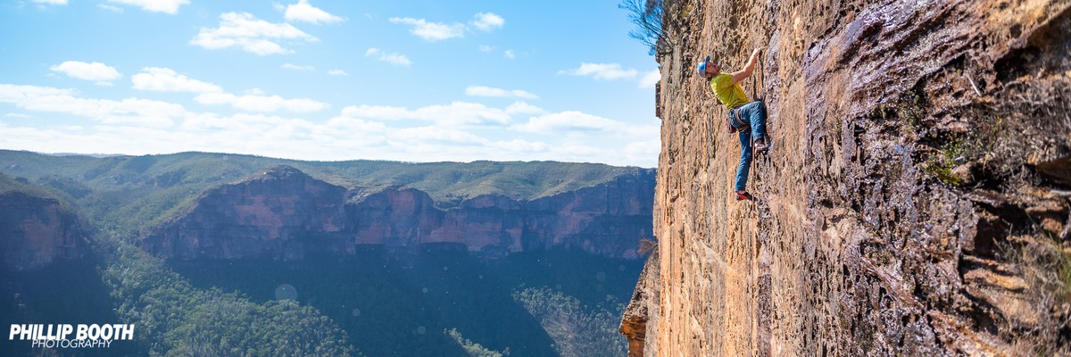
1.1. Blue Mountains 7,093 routes in Area
- Summary:
-
Sport climbing, Trad climbing and other styles
Lat / Long: -33.572195, 150.373713
summary
Located predominantly on Darug and Gundagurra Country. Massive amounts of rock, easy access, high quality routes, a beautiful location, what more could you want?
description
Driving up into the Blue Mountains is like entering a fortress, for once you are up in them, you are on a plateau surrounded on all sides by cliffs. It is in this almost suburban bush surrounding, that some of Australia's best climbing resides. From big adventurous walls, to smaller single pitch sport climbs, to fantastic trad climbing, the Blueys has a bit of it all. All this comes amidst the smoky blue green vistas of the Blueys, which on a good day are so peaceful you will never want to leave.
The Blue Mountains are a unique destination offering a very civilised climbing experience, courtesy of places like Katoomba and Blackheath, that sport a healthy cafe culture. The mornings can begin with a coffee in Blackheath and a visit to the bakery. The day can then be spent thrashing yourself on some of the countless sport routes, or scaring yourself silly on some sandy trad horror show. The evening can then culminate in Katoomba with a nice café meal and possibly a film. For a more traditional experience head to Mt Victoria for the rickety old theatre. Most of the crags are within easy driving distance of each other, and in some cases easy walking distance. The most popular area is around Blackheath which offers the highest concentration of quality climbing to be found. There are many other areas though which are very good, most of which are within half an hour to an hours drive away. For most people these days, the Blueys is really a sport climbing destination. Apart from Nowra, there is no other place where you will find so many sport routes. There is still plenty of trad climbing though, even though the sandstone is not as suited to trad climbing as the Grampians and Mt Arapiles, being generally poorer in quality. Mt Piddington and Mt York are probably two of the best places to trad climb, although both crags offer some sport climbing. Around Blackheath the best sport area is Centennial Glen, although Upper Shipley probably offers more options for the intermediate climber.
For the beginner climber the Blue Mountains is nowhere near as good as Arapiles or the Grampians, as the easier routes do tend to be the chossier ones. For the intermediate to advanced climber though, the Blue Mountains is fantastic. The beginner climber should not be put off however, as the Blue Mountains probably has more climbing companies offering introductions to climbing than anywhere else in the country. The Blueys is a fantastic place to spend time, although it can be a little more expensive than other areas, due to having so many more temptations.
access issues
The Blue Mountains are a World Heritage listed area. The Grose Valley, the cliffs around Katoomba and much of the Narrow Neck peninsula are part of the Blue Mountains National Park which is managed by the NPWS. The Western Escarpment - where most of the climbing is - is Crown Land managed by the BMCC. While the NPWS Plan of Management nominates several locations in the National Park where rock climbing is deemed appropriate, the majority of the climbing remains unacknowledged. To maintain access our best approach is to 'Respect Native Habitat, Tread Softly and Leave No Trace'. Do not cut flora and keep any tracks and infrastructure as minimal as possible.
Practically all crags are either in National Park or in council reserve: dog owners are reminded that dogs are not allowed in National Parks at any time and fines have been issued, while for crags on council reserve the BMCC leash law requires that dogs be on-leash.
For the latest access related information, or to report something of concern, visit the Australian Climbing Association NSW Blue Mountains page at https://acansw.org.au/blue-mountains/
approach
An hour and a half’s drive west of Sydney (80kms). There is a train line that runs right across the top of the Blue Mountains plateau and many stations (e.g. Blackheath) are in very close proximity to the crags. There is also a bus service.
where to stay
Camping is limited due to semi-suburban location so near to Sydney. Many climbers choose to Air BNB rather than camp - or just day trip from Sydney (the suburban train line passes through the mountains). The most popular free campground is at Mt York (Mt Victoria). This is a small area which can be totally full during holiday periods. It is conveniently located near ma couple of excellent climbing crags (Bardens Lookout & Mt York). It is a first come first get campground - there is no booking system. Megalong Valley also has a couple of free campsites but they are a long way from the crags if you don't have a car and have limited facilities. Blackheath has a BMCC operated caravanpark & campground which offers security and showers and is in the centre of the main climbing hub. Katoomba has plenty of hostels and a caravan park and there are many bed and breakfast type places through the mountains, if you can afford it. It really is a place where a car is needed to make the best of the area.
ethic
Although sport climbing is well entrenched as the most popular form of Blueys climbing, mixed-climbing on gear and bolts has generally been the rule over the long term. Please try to use available natural gear where possible, and do not bolt cracks or potential trad climbs. If you do the bolts may be removed.
Because of the softness of Blue Mountains sandstone, bolting should only be done by those with a solid knowledge of glue-in equipping. A recent fatality serves as a reminder that this is not an area to experiment with bolting.
If you do need to top rope, please do it through your own gear as the wear on the anchors is both difficult and expensive to maintain.
At many Blue Mountains crags, the somewhat close spacing of routes and prolific horizontal featuring means that it is easy to envisage literally hundreds of trivial linkups. By all means climb these to your hearts content but, unless it is an exceptional case due to some significant objective merit, please generally refrain from writing up linkups. A proliferation of descriptions of trivial linkups would only clutter up the guide and add confusion and will generally not add value to your fellow climbers. (If you still can't resist, consider adding a brief note to the parent route description, rather than cluttering up the guide with a whole new route entry).
If you have benefited from climbing infrastructure in NSW, please consider making a donation towards maintenance costs. The Sydney Rockclimbing Club Rebolting Fund finances the replacement of old bolts on existing climbs and the maintenance of other hardware such as fixed ropes and anchors. The SRC purchases hardware, such as bolts and glue, and distributes them to volunteer rebolters across the state of New South Wales. For more information, including donation details, visit https://sydneyrockies.org.au/rebolting/
It would be appreciated if brushing of holds and minimisation/removal of tick marks becomes part of your climbing routine. Consider bringing a water squirt bottle and mop-up rag to better remove chalk. Only use soft (hair/nylon) bristled brushes, never steel brushes.
The removal of vegetation - both from the cliff bases and the climbs - is not seen as beneficial to aesthetics of the environment nor to our access to it.
Remember, to maintain access our best approach is to 'Respect Native Habitat, Tread Softly and Leave No Trace'. Do not cut flora and keep any tracks and infrastructure as minimal as possible or risk possible closures.
For the latest access related information, or to report something of concern, visit the Australian Climbing Association NSW Blue Mountains page at https://acansw.org.au/blue-mountains/
1.1.1. North Lower Blue Mountains 101 routes in Area
- Summary:
-
Bouldering, Sport climbing and other styles
Lat / Long: -33.604149, 150.620899
description
The Bells Line of Road to Springwood Road. And around the lower Grose River area.
1.1.2. Lower Blue Mountains 691 routes in Crag
- Summary:
-
Bouldering, Trad climbing and other styles
Lat / Long: -33.759962, 150.600228
summary
The lower mountains features a variety of areas from gorges, gullies, gulches, caves, waves, and much more. Renowned for its loose sandstone, the climbing can be quite friable!
description
The lower mountains is made up of several jurisdictions, including national park and crown land. The rock quality varies, with much of the area still un'scent.
access issues
Be sensible.
approach
From Sydney cross the Neapean river and you are there!
1.1.3. Mid mountains 11 routes in Unknown
- Summary:
-
All Sport climbing
Lat / Long: -33.718476, 150.462026
description
Anything between Springwood and Wentworth falls
1.1.4. Kings Tableland 18 routes in Crag
- Summary:
-
All Trad climbing
Lat / Long: -33.818494, 150.396260
1.1.5. Leura 207 routes in Crag
- Summary:
-
Sport climbing, Trad climbing and other styles
Lat / Long: -33.673154, 150.375444
1.1.6. Katoomba Area 872 routes in Crag
- Summary:
-
Sport climbing, Trad climbing and other styles
Lat / Long: -33.512553, 150.329561
summary
Home to the jewel of the Blue Mountains, Diamond Falls.
1.1.7. Medlow Bath 292 routes in Crag
- Summary:
-
Sport climbing, Trad climbing and other styles
Lat / Long: -33.669424, 150.308713
summary
Diverse crag with lots of high quality low grade climbing all the way to epic adventures.
description
Something for everyone and a quick walk from Medlow Bath station. The Sunbath has a good smattering of easy to moderate sport routes, Reservoir Dogs and The Sporting Complex have some excellent rap in, climb out sport routes, the Colosseum has some mega trad and mixed routes and when Alex Megos visited he hit up the mega steep, hard routes at The Underworld - and that's only half the areas at Medlow! Get amongst it.
access issues
Many of these crags are located on private property - and could be closed at any time. Do not piss off local residents by parking cars at the end of Belgravia St - park back near the train line and walk 100m up the road.
The Belgravia St descent track and Devondale bouldering is located on private property (it is NOT owned by the Hydro Majestic Hotel). This property changed hands in 2018 for a cool $1.9 million, and the new landowners have not expressed concerns about the public on their land - yet. It is very important that this property is treated with utmost respect - and if you are approached by the owners then please be courteous. If they have concerns please get them to contact ACANSW.
Blue Mountains City Council is the land manager for The Block, Katoomba Bros, Sandpit, Valley Farm & Sooty Crag. Access to all these areas is via the private land mentioned above.
The mega lux Hydro Majestic Hotel owns private land that includes the Sunbath Wall, Reservoir Dogs, Sporting Complex, The Underworld & Pole 28. Access to to these private land crags is NOT guaranteed and could be closed at any time.
DJ crag is also located on private property - with the owner apparently living below the cliff itself.
approach
The Sunbath, Valley Farm, Sooty Crag and Colosseum
Coming from Sydney take the first exit on the left after the Hydro Majestic hotel. Park car on the corner of Belgravia St & Station Street opposite the railway buildings.
Walk to the end of Belgravia St and follow the signposted track - don't go down any driveways. Pass two indistinct trails turning off to the right and another coming in from the left and take the third right hand turn. (If you get to a concrete platform you have gone too far, back track about 30m).
Follow the path down over some fallen trees, then down a bunch of switchbacks to the bottom of the wall. On the left is Schwing wall and on the right is The Block. The track continues around The Block and to the edge of the cliff where a dead tree rests on the edge. Follow the path down the cliff via cut stairs and ladders.
At the bottom turn right for Valley Farm and Sooty Crag, and left through the tunnel for The Colosseum.
Flying Fox, Pole 28 and Three Brothers
From the highway turn onto Bellevue Cres 100m south of the service station, then left down the dirt fire trail.
1.1.8. Blackheath Area 1,150 routes in Crag
- Summary:
-
Sport climbing, Trad climbing and other styles
Lat / Long: -33.628216, 150.294680
summary
The heart of Blue Mountains climbing.
1.1.9. Mount Victoria Area 1,898 routes in Crag
- Summary:
-
Trad climbing, Sport climbing and other styles
Lat / Long: -33.563365, 150.262970
description
Once the focus of Blueys climbing, it's now seen a fair bit of regeneration. Mt Piddington is our premier trad climbing area. Lots of variety from old school mixed climbing through to state of the art sport climbing and even bouldering. Mt York has free camping and is the 'end' of the Blue Mountains - it's also the Blueys instructional area. Mt Vic has a great pub, an old art deco movie theatre, a museum and many fine bushwalks for the non climbers. It's 6km from Blackheath.
1.1.10. Bells Line of Road & Chifley Rd 1,083 routes in Crag
- Summary:
-
Sport climbing, Trad climbing and other styles
Lat / Long: -33.514234, 150.415913
summary
This is the place to head for grand adventures. The multipitch sport routes Pierce's Pass are not for the faint hearted, and not to be missed.
approach
The turnoff onto Darling Causeway, which leads you 10km north to Bells Line of Road, is at Mt Victoria.
1.1.11. Newnes Plateau 484 routes in Area
- Summary:
-
Sport climbing, Trad climbing and Rock climbing
Lat / Long: -33.343670, 150.207883
summary
Remote cragging along the rim of the Wolgan Valley and hidden canyons to the west of it. Long drive on dirt roads and short walk-ins.
1.1.12. Mt Blaxland 6 routes in Crag
- Summary:
-
All Rock climbing
Lat / Long: -33.547059, 150.105883
summary
Alpine-style granite climbing on the north face of a peak with no public access.
description
Mt Blaxland is a prominent peak named for the final point of Blaxland, Lawson and Wentworth’s 1813 Blue Mountains crossing, opposite Lawsons and Wentworths Sugarloafs, on the banks of the Coxs River, about 9km south-west of Lithgow and 3km south east of Lake Lyell.
The climbs are on the north-facing side of the mountain on a ~70m high sloping broken granite cliff with an alpine appearance.
access issues
Although it is located in a 50ha Crown land reserve bordered to the north by the Coxs River, there is no current public access, either from the Old Bathurst Road (former Coxs Road) to the south, or McKanes Falls Road to the east.
approach
Via Great Western Highway and McKanes Falls Road. Thereafter no public access across private land.
ethic
Minimal impact natural climbing.
history
Mt Blaxland was the end point of Blaxland, Lawson and Wentworth’s Blue Mountains crossing of 1813, named by George Evans (of Evan's Crown fame).
Someone please add the climbing history.
1.1.13. Uber Land 20 routes in Crag
- Summary:
-
All Bouldering
Lat / Long: -33.513328, 150.139069
description
A bouldering crag by the side of the highway
approach
Uber Land is situated 17 minutes from Mount Victoria heading towards Lithgow on the Great Western Highway. Set your odometer to zero at the traffic lights in Mt Vic (Opposite the Imperial Hotel). The parking area for Uber Land is 15.7 km on the right hand side of the road (See map). It is easier to turn in the RTA Stockpile site (major roadworks going on here as at october 2016) on the left and then cross the highway. Once parked, the Cicada Boulder should be visible through the trees.
Can now park on forty bends road and cross the highway on foot.
ethic
Please stick to worn paths so as not to damage new growth. There is huge potential for new problems of all grades and unlike many Sydney bouldering areas all the problems finish on top of a boulder! The Uber boulder, the highballs or no balls and the Fabulous Baker boulder deserve particular attention. Be prepared to clean the problems with a stiff brush. A wire brush is not needed as most of the lichen has been burnt and only charcoal remains. There are several lines that have been cleaned and not claimed. On the topo there are a few hints to classic lines that deserve more attention.
history
Dylan Fletcher and Sieta Whitehead discovered Uber Land once the bush fires made the boulders visible from the Great Western Highway. The area was found just before Dylan and Sieta left for overseas. Dylan had also been recovering from two broken legs and so he was resigned to cleaning problems and clearing up rubbish. Most of the first ascents are courteous of Sieta, Ben Wood and Mark Baker. Several cairns have been left to mark paths in preparation for the bush regeneration.
Data retrieved from :http://web.archive.org/web/20030308173802/http://www.climbing.com.au/news/news.php?page=news_uber_231102.htm
1.1.14. the lost city of clywdd 6 routes in Area
- Summary:
-
All Trad climbing
Lat / Long: -33.509277, 150.163814
summary
A series of crack systems in nearly every pagoda and cliff line, finding the history of this place is vague but there is old lookouts, fences, picnic benches and steps carved into the sandstone here.
description
Almost every gully here has a bunch of cracks with the cliff in between each gully also containing crack or seams, the sandstone here is pretty good for blue mountains standards (subsequent visit by others has put doubts on this claim). most climbs have being done in two pitches just due to rope drag but the ciff line here is predominantly 30m high. this is a eastern facing gully that looks back onto mt york which is pretty rare to find a gully that gets sun all day and protected from the prodominant westerly winds, you can hide in your desired area to suit the weather conditions. this is a 100% trad area, so rack up and get your adventure on.
access issues
This area seem highly unstable and Council have closed the old tourist lookout here most likely due to landslide potential. A very large house sized rock has fallen from under the lookout in 2023/2024 - and it looks like others will come off soon as well. Take extra care here - it is not Piddington.
approach
Carpark: -33.5066, 150.1632 Access Gully: -33.5083, 150.1656 Walk in distance: 300m (5-10minutes)
From intersection of Brown Gap Rd, follow Hassans Wall Rd for 1.6km west and park in single vehicle spot on the left/south side of the road. There is the remains of an old bench seat here (hidden from the road).
Follow well worn old tourist track downhill for 250m until a metal fence is reached. Walk between gap in fence and continue on track to small concrete bridge over fenced rock crevasse (it's deep!). Leave tourist track here and scramble 25m south-east down side of pagoda to gully. Down this to base of cliff.
ethic
No bolts or hardware, everything has being done ground up onsight here for the sense of adventure, bring your helmets and brush as you may well still be cleaning as you climb
1.1.15. Cox's River Bouldering 78 routes in Crag
- Summary:
-
Mostly Bouldering
Lat / Long: -33.733184, 150.200386
description
Granite bouldering crag along the Cox River bed that was developed a number of years ago, but information about the routes seems to have been lost or is top secret. If you have any information or do any as yet unrecorded ascents, please add it here.
approach
Park your car on Aspinall road, 900 m before the Dryridge Estate (at 226 Aspinall Road, Megalong Valley) where the six foot track meets Aspinall road. Follow the six foot track on foot and either turn right down a fire trail past a sign that says 'private land' and follow this down to the get to the River Junction Sector or continue for another 10 min along the track to get to the Six Foot Track Sector with the One Foot Crack boulder clearly visible right on the track.
1.1.16. The Overlook 36 routes in Crag
- Summary:
-
All Sport climbing
summary
200m cliff line facing east
access issues
Crag under development
1.1.17. Black Site Crags 45 routes in Area
- Summary:
-
Mostly Sport climbing
Lat / Long: -33.512196, 150.280653
1.1.18. Lithgow Valley 62 routes in Area
- Summary:
-
All Bouldering
Lat / Long: -33.485742, 150.165496
summary
Bouldering in the wooded hills surrounding Lithgow. Great location for a quiet day, you'll have the place to yourself, at moderate grades, Lithgow is the perfect destination.
description
The hills surrounding the town of Lithgow are covered in rock. So many boulders everywhere! So much potential. Needs more people out here to develop it all. The problems are found on small cliff lines and free standing boulders. The rock quality is good and landings are mostly friendly. Approaches are super short. Areas are all very close together so, currently, it is possible to visit all of the areas in a day.
access issues
Be mindful of others as these areas are all close to housing and access is often also behind or next to houses. Take out what you take in.
approach
Head West from Sydney. Can't miss it.
1.1.19. Summer Crag 33 routes in Crag
- Summary:
-
All Sport climbing
description
South facing walls perfect for summer
access issues
New crag under development
1.2. Wolgan Valley 464 routes in Crag
- Summary:
-
Trad climbing, Rock climbing and other styles
Lat / Long: -33.226438, 150.252601
summary
Remote trad and mixed climbing in a stunning environment. Many truly excellent, long or multipitch routes on great rock. Great hiking, camping and canyoning for rest days.
description
Cracks, faces, sand, and adventures abound in this extension to the Blue Mountains. A must visit for any Australian who considers themselves a trad climber.
approach
From Lithgow drive west on Great Western Highway for approx. 7 kms and take the Mudgee Road exit on left. Follow this the Wallerawang Power Station (on left) for several kms till an intersection (service station) where the Wolgan Road turns off to the right. It's about 35 kms to Newnes campground from here with the final several kms only being dirt road. Approach to various crags listed in their sections.
where to stay
Newnes campgrounds has numerous free sites on both sides of the river, with minimal toilet facilities spread about.
ethic
National Park. Trad climbing. Adventures...
history
Long and varied...
1.2.1. Eldorado 10 routes in Area
- Summary:
-
Mostly Trad climbing
Lat / Long: -33.192889, 150.240005
1.2.2. Coal Mines Cliff 48 routes in Cliff
- Summary:
-
Mostly Trad climbing
Lat / Long: -33.228860, 150.223963
Rap from a tree above "Barton's Effort" down to the anchors (chains, and a UB), about 5m down from the top of the wall. Your 60m rope will just reach the ground from the anchor.
Alternatively, you can rap down from a tree at the top of "Absolutely Sweet Marie" to the anchors halfway down, and make a second rap to the ground.
description
Most bolts are bash-ins, and now 25-30 years old. Please consider contributing to rebolting.
approach
Park at the Glowworm tunnel turnoff (https://goo.gl/maps/JcG1UTcvjzU9iXgQ8) on Wolgan Road. Cross the stream and go up Old Coach Road (signs for the Glow Worm tunnel).
At one of the switch backs, after you're above the big water tank you can bush bash up a gully to the Glow Worm Walking Track (gully is roughly here https://goo.gl/maps/A8mP5SKZTYqQpNkq6). Alternatively you can follow Old Coach Road until it meets the Glow Worm Walking track.
Either way turn right once you reach the Glow Worm Tunnel track (it runs along an old railway line, though the railway line has been removed).
Follow the track until you cross a stream/gully. From here continue on 150m or so until you reach a small cairn on your left.
Follow a faint climbers track and cairns until you reach the crag. When you get to the wall you'll be at the left hand end (near "Absolutely Sweet Marie").
Many of the initials for the climbs have been marked.
Total approach is approximately 2ks.
descent notes
For a "trad" crag this cliff has been surprisingly over-equipped with bolted rap chains. When nearing the top of most routes keep your eyes open and there will usually be a rap chain (or three) nearby. If you do need to top out and can't find a good rap point, the cliff gets smaller at the right (west) end, you don't need to go far before there are ample trees to get you down even if you only have one rope and need to do multiple raps.
If you just have a 60m rope there are a couple of options we found at the left hand end of the crag for getting down from the top of the cliff.
The chains on the tree at the top of "Fat Lipped"/ "Thin Lipped" will not get you to the ground on a 60m rope.
1.2.3. Old Baldy 104 routes in Area
- Summary:
-
Trad climbing, Rock climbing and other styles
Lat / Long: -33.168475, 150.244899
- after 150 meters turn left uphill on obvious trail between two stone cairns. Wind your way up into a saddle and up and left you will see a large white patch of cliff (this approach is described in 'The Last Samurai' [684220764], but the path was not to be found Sept-2019)
- after about 900m, on the left there is a flat area with a very shy path that will becomes more visible going uphill. This will take you at the bottom of 'The Chain'
approach
Walk from Newnes campsite on maintrail left of river, from this trail there are apparently few ways to the 'Lower Cliff':
There is then a track going alongside the whole cliff, keep walking East (right facing the cliff) will take you to the 'Solo Gully', which is the easiest why to reach the 'Upper Cliff'. The 'Upper Cliff' is accessible also climbing one of the long routes on the 'Lower Cliff'. This GPX file contains the path and some of the climb location of both 'Lower Cliff' and 'Upper Cliff': https://1drv.ms/u/s!AicnXbnwQDGvhaF9kpRdJkjIGScpGA?e=VA0RMh Most of the lines have initials on them.
1.2.4. Petrie's Gully 25 routes in Area
- Summary:
-
Rock climbing, Trad climbing and Aid climbing
Lat / Long: -33.164014, 150.254813
approach
Follow the river east from The Paddock, eventually crossing the Petrie's Gully tributary and continuing to follow the river for a brief distance to an obvious track. Head north on this, looking out for a cairn marking the start of a very indistinct trail which zigzags up the steep loose slope. When the cliff line is eventually gained, carry on northwards until a chain is found, use this to gain the next level. (If you reach a giant sandstone arch, you have gone too far north.) Continue north along the base of the cliff, carefully at times, until a scramble up can be made. It should bring you to Channel 9, with routes to the left and right.
1.2.5. Wilderness Areas 33 routes in Area
- Summary:
-
Trad climbing, Aid climbing and Rock climbing
Lat / Long: -33.208913, 150.368130
1.2.6. Exploding Galaxies 29 routes in Area
- Summary:
-
Rock climbing, Trad climbing and Aid climbing
Lat / Long: -33.176869, 150.267343
Get yourself across the Wolagn River, to the dirt road running along the valley floor (Joadja Street)
Follow Joadja Street East to the steel barricades (parking area and NPWS board)
Walk 100m or so past some puddles to where the road forks at a "Ruins Walk" sign
Take the right fork leading uphill
After 300m, turn R at the Ruins Walk sign (straight ahead goes past two oil storage tank bases")
Wind uphill for 200m to meet the Eastern end of the Coke Oven ruins
A "Ruins Walk" sign points R, but take the L turn at this T-intersection. The old road curves back R around the Eastern end of the ruined coke ovens
After only 40 big steps, stay on the old road and curve around L (signposted "Ruins Walk")
The old road goes slightly uphill and in 100m you pass two tiered chimneys on the right and another Ruins Walk sign
After 250m you reach a fork. The L fork is signposted "Ruins Walk" but take the R fork going slightly uphill. There is a large open area on the L
Continue downhill. After about 550m you pass a large ferny clearing on the R (which has an excellent view of the "big yellow corner" of Superman)
Ignore the L fork here and continue straight ahead, downhill 100m to cross a large, rocky creek bed (usually dry - this creek is the route up to Firefly and Looking Glass canyons). Apparently, this is the best place to head up the hillside to Superman and Clark Kent
You see more ruins and 30m past the creek bed on the R is the signposted entrance to a former shale mine
250m past the creek bed, you see some ruins (signposted unstable relics) up off the road on the R
Only 50m or so past here, as the main road curves L and uphill you see a minor and overgrown vehicle track branch off to the R. (It branches off near a large fallen boulder on the R, 40m before the main road is seen to disappear around a sharp R bend). [As of June 2019, the track is faint but still reasonably identifiable. I would say it's next to a couple of boulders]
Branch off R onto this minor vehicle track
After 40m, veer R across a grassy flat area and surmount a short embankment to gain a flat terrace [As of June 2019, this terrace has a lot of stinging nettle so take care!]
From the top of this embankment you see a large cairn 30m away to the R. This is 2.3km away from the steel barricades and parking area. The route uphill starts here and takes 15-20 minutes
It's difficult to find the first 30m or so of track, but if you head straight up the hill from the cairn you'll come across an otherwise easily followed track (marked by cairns and white paint spots [as of June 2019, plenty of cairns but no paint]) which generally trends leftwards and leads to a break in a small lower cliffline
Once above this obstacle, you can see the main cliffline above a lightly wooded rubble-strewn slope. Although a track was marked up this final slope in the past, it isn't well defined anymore, but if you head up to the L you'll gain the firmer footing of a faint ridge and by climbing directly up this you will meet the cliff near Andromeda at the R (west) end of the crag
summary
North facing crag with plenty of sun for a cold winter's day
approach
Approach description adapted from the excellent "Wolgan Valley: Selected Climbing Areas" by Wade Stevens. A very good approach description and accurate as of June 2019. Steps 1-6 describe the approach to the Coke Ovens ruins (from which you either can launch up the hill to the Coke Ovens crag or keep walking around to Exploding Galaxies):
This will get you to the W end of the crag and the bivvy under the slab. You will need to walk around to the L for another 10 minutes or so to get to E =mc2
where to stay
There is a nice natural spring that seeps out underneath a large overhang next to the Roswell incident. It is a comfy place to sleep the night, much warmer than down in the valley. We had a lot of rain one night and we got wet but not soaked.
1.2.7. Coke Ovens Cliff 121 routes in Cliff
- Summary:
-
Mostly Trad climbing
Lat / Long: -33.177230, 150.252312
description
A north facing cliff opposite Old Baldy. Great winter cragging.
Note walking up Western Gully is the quickest way to the Coke Ovens Upper cliff line. It's about 200-300m R of the Sizzler sector - walk straight up hill from the car.
approach
60 minutes if walking from fording of river, 45 minutes if walking from locked gate.
From Newnes, ford the river and walk or 4wd east to the locked gate with the Newnes Industrial Ruins map board. Continue walking east to the coke ovens ruins. Walk behind the coke ovens to find a brick cairn approx one third of the way down on the left hand side. Veer into the bush at this point, heading past the low brick structure on your left which is right next to the big boulder. Turn left after the boulder and head towards the cliffs to find a well established (and steep) zig zag climbers' track. Follow this very well cairned track up to the crag coming out at Star Wars.
1.2.8. Coke Ovens Upper 10 routes in Area
- Summary:
-
Aid climbing, Rock climbing and other styles
Lat / Long: -33.177875, 150.251492
approach
If you do one of the routes which top out, there is an easily accessible rap anchor above TBFA. 3 raps (10m, 45m, 35m) from there get you down to the halfway ledge. Keep a swing going on the 45m abseil in order to gain TBFA's 1st anchor, it doesn't need to be much but is critical!
1.2.9. Desperado Walls 6 routes in Area
- Summary:
-
Trad climbing and Rock climbing
Lat / Long: -33.180364, 150.244675
description
The cliffs on Magic Mountain directly above the Newnes pub. Faces SW so is shady for most of the day. Take care, some climbs have only had one ascent.
approach
Take the Magic Mountain walking track (same access path as for The Point / Landslide Area) - cross the creek just past the Newnes pub, turn left to the Industrial Ruins and small campground. 50m on left look for rock cairn and tape in trees marking the start of the magic Mountain walk (a good walk in itself to the top of the cliffs with great views and non-climber friendly). Walk up the track for about 20 mins - Desperado Walls are on the right of the track. Leave the track at the first painted arrow for the Lower Cliff, and sidle right around the cliffs for about 400m until you spy the major lines marked "Z".
For the Upper Cliff, continue up the track trhough the shale band (that created the halfway ledge) until you come to a second painted arrow. Scramble carefully here along a vague track until the cliff gets bigger and some major lines are visible.
1.2.10. Capertee Creek Cliffs 31 routes in Area
- Summary:
-
All Trad climbing
Lat / Long: -33.168556, 150.232250
description
An average sort of crag by the Wolgan standards, Capertee Creek Cliffs suprisingly rank third after the Coke Ovens and Old Baldy for the number of climbs. From the valley below, the appearance of the crag is hardly likely to leave one transported and breathless.
The cliff, for the most part, faces in a south-easterly direction as it overlooks Capertee Creek. The short section of the cliff at the right hand endhas an easterly aspect and looks down on the Wolgan River and across to Desperado Walls. The climbing area extends from just above the obvious house on Capertee Creek, rightwards for over a kilometer to the start of a long amphitheatre which curves around to join Cooks Cliffs.
history
This area was developed in the late 1960's & 70's, and has had precious little attention since then, with most climbers focussing on the longer, cleaner routes on Old Baldy and the Coke Ovens.
1.2.11. The Point / Landslide Area 8 routes in Area
- Summary:
-
All Trad climbing
Lat / Long: -33.179309, 150.244954
description
Used to be known as the Landslide Area (in the 1984 Penney guide), does not appear in the current guide, and is now described in SRC guide as "The Point". From the Capertee Campsite area, the area is the obvious cliffs on Magic Mountain on the South side of the river, facing Old Baldy, and opposite the Newnes pub. A huge landslide area is visible - there are two old climbs to the left of the scar, but the main climbing area is to the right of the landslide.
approach
Approach is up a well-marked trail to Mystery Mountain. Cross the river at the ford and turn left towards the small campsite / Industrial Ruins. 50m down this road on the right is a cairn and some tape in a tree marking the start of the trail up Mystery Mountain. This well-marked trail (white paint marks, arrows) goes steeply up a ridge and all the way to the top - it is a great walk in itself, and a good way for non-climbers to get to the top. The same track leads to Desperado Walls.
For The Point, continue up the track for 20 minutes until you get to a large, downwards sloping bulbous gum tree, with white tape around the first fork. Swing left here at a short cliff band, and follow a high path, keeping left until you have to squeeze through a short boulder. Continue left until you reach the main wall. You should be able to see a karabiner about 12m up below a large black diagonal flake system (Crystal Cylinders) Descent is via the walking track above the cliffline.
1.2.12. The Badlands 39 routes in Crag
- Summary:
-
All Trad climbing
Lat / Long: -33.215737, 150.243365
summary
New crag out in the Wolgan. Andrew Penny put up a route back in the 80's at the far Western end of the crag and called the area Penrose Gully. There are tonnes of potential new routes out there.
Bolts are glue in stainless steel requiring bolt brackets. Cliff faces N/W. Don’t go on a hot summer’s day
access issues
There are no defined paths to the crag as of yet. The listed routes are spread over 1km of cliffline. It's easiest to get orientated as to where you are if you head to the left (north-east) looking at the cliff as there is a concentration of routes (Home By Six - "Flake-ation"). Some hundreds of metres to the south-west is another concentration of routes, Mouse Land - "Just Don't Be Weak".
There is an abseil point 2UBB approx 10m West of top out of The Badlands. 40m abseil to ledge, then abseil off 2BB 30m to ground. Descents of routes are listed.
approach
All GR's for Ben Bullen topo map 8931-4S Drive 2.4km past the ford for Coal Mines Cliff and park in a small cutout on the side of the road opposite a gate, as the road bends round to the north. GR 430 221. About 50m upstream from the parking area is a broad fallen tree allowing a dry crossing. There is not presently a defined trail to the crag. The crag itself is about 1 km long. There are a couple of usable approaches:
Home by six - Flake-ation area: The steep, direct line will take you to the northern end of the crag. After crossing the creek head up the hill, reaching the Newnes Ruins / Glow Worm trail after about 5 minutes. Follow the trail briefly (80m) towards the Glow Worm tunnel and leave it to continue up broad spur till you reach the cliffline (20 min), hopefully noting some rock cairns along the way. After reaching the lower cliffline, head right approx. 50m until you can scramble further up with the aid of a handline. Continue up to main cliff line along the path of least resistance where you should find "Flake-ation".
Mouse land - Just don't be weak area: An alternative, slightly gentler approach will take you further south along the crag, reaching Glockenspiel Crack after about 45 minutes. Walk in as for Home by six - Flake-ation until you reach the Newnes Ruins / Glow Worm trail. Follow this towards the Glow Worm tunnel for 400m until a fence is reached.GR 426 21. Go through the fence and then follow the line of least resistance uphill till a small knoll is reached GR 427 214. Continue straight up past some huge house sized boulders to the cliff line which should lead you to Glockenspiel Crack.
where to stay
Camp at the "Little Capertee" campground, or stay at the cabins.
https://www.nationalparks.nsw.gov.au/camping-and-accommodation/campgrounds/newnes-campground
ethic
"Old School" is the vibe we are after. Ground up if possible. Limited bolts, viewed as an extension of trad gear (maybe think carrots rather than rings). What's there has often been bolted by hand on lead, and should be assessed carefully before committing to it. However the classic "trade" routes have had bolts replaced with glue in stainless carrots.
history
First visited by Andrew Penney one day in 1984, when he put up the single route Zoser (including the installation of a bolt and the customary painted square and initial!). Fast forward a few decades: Marty Doolan spied the line of The Badlands from the road and checked it out one day with Hugh Ward. The rest is history.
1.3. Capertee Valley 11 routes in Area
- Summary:
-
All Bouldering
Lat / Long: -33.052465, 150.211748
description
Basically another Wolgan Valley, but bigger and possibly even more gobsmacking.
approach
Not much further to drive than Newnes due to faster roads.
ethic
Lots of climbing has been done but tends not to be written up, to keep this as an adventure area.
1.3.1. Ganguddy-Dunns Swamp 9 routes in Crag
- Summary:
-
Lat / Long: -32.833202, 150.205860
summary
DWS in a scenic location. Lots has been climbed here but the ethic is to keep it off this website and leave the adventure for everyone.
description
A nice DWS area on the sides of the Dunns swamp near Rylstone/Kandos. Rock is sandstone of varying quality - mostly poor and big grain. Little potential for roped climbs due to cliff height/quality/moss.
access issues
Many of the cave areas around the campsite are important Aboriginal occupation sites containing rock art and have been the scene of scientific studies of the cave floors (finding stone tools etc). Please avoid bouldering in the vicinity of caves or overhangs. Rock art can be incredibly hard to spot with the naked eye and ignorance has already destroyed much of the art in this area. Please do not add boulder problems to this website - it can only end in tears.
approach
Located on the western side of the Wollemi National Park. Drive to Rylstone and turn onto Narrango Rd, follow for approximatly 23km, following the signs to Dunns Swamp. From the camping area the majority of the climbing is on the western end (down stream/dam side) of the river.
where to stay
Awesome camping right next to the river. Perfect for campers, caravans and tents. Has drop toilets, no showers or running water.
1.3.2. Genowlan Mountain Walking Track 2 routes in Area
- Summary:
-
summary
Boulders and cliffs along the Mount Genowlan Summit track
1.4. Evans Crown 136 routes in Crag
- Summary:
-
Trad climbing, Sport climbing and other styles
Lat / Long: -33.546545, 149.924710
summary
Fantastic granite climbing only 2 hours from Sydney
description
Evans Crown Nature Reserve (“Tarana” after the nearby hamlet of the same name) is a small (425ha) nature reserve in the Fish River grazing country on the Lithgow side of the Blue Mountains. It consists of a forested outcropping of granite domes and tors – and from a climber’s perspective, is the nearest quality granite climbing to Sydney, and a welcome change from the sandstone cliffs of the Blue Mountains. There are more than 120 established routes here, mostly dating back to the 1970s and ‘80s, often friction climbing on slabs, faces and steeper boulders and features. The three-dimensional climbing, sometimes heady runouts and beautiful setting all contribute to a unique climbing experience.
access issues
Evans Crown Tarana is a Nature Reserve administered by the NSW Office of Environment and Heritage. As a Nature Reserve (and unlike National Parks) the primary purpose of the administration is preservation of natural and cultural values, NOT recreation. While rock climbing is noted as a recreational use in the 2009 Plan of Management (this can be downloaded from http://www.environment.nsw.gov.au/parkmanagement/EvansCrownMgmtplan.htm) it is not officially encouraged, and if the OEH believe the impact of climbing is detrimental to the natural or cultural values of the area, it can and will be banned.
The Parks and Wildlife Service requested at one stage that all climbers register their intention with them prior to climbing – this no longer seems to be the case. However, there is an existing ban on new routes, brushing or cleaning existing or new routes, no “gardening” or disturbing vegetation, no marking routes, and no camping or fires in the Reserve. No new bolts may be placed, and technically re-bolting is also forbidden.
So – in addition to the usual “Leave no Trace” guidance, please make every effort to minimise any signs of climbing activity in order to preserve our precarious access to this special place.
approach
From Sydney drive over the Blueys on the Great Western Highway towards Lithgow. As you reach the outskirts of Lithgow, turn left at the petrol station onto Magpie Hollow (Rydal) Rd towards, and then past, Lake Lyell. After about 10.5km, turn right and then almost immediately left at a T-intersection onto Sodwalls-Tarana Rd. Follow this road about 10km through Sodwalls until turning sharp left onto the dirt Honeysuckle Falls Rd.
Stop 1.5km along Honeysuckle Falls Rd at the small parking area with a sign "Evans Crown Nature Reserve".
Head up the well-formed track for about 20 minutes until you hit the signposted intersection at the top. The unformed track to the left will immediately bring you to the front of Deckout Buttress.
where to stay
The Tarana Hotel has rustic cabin accommodation and basic meals - see http://www.taranahotel.com.au/ The more major township of Lithgow is only a short drive away with plenty of accommodation.
Free camping is available at Flat Rock campsite on the Fish River about 15 mins drive from Evans Crown - see http://www.australiancampsites.com.au/index.php/component/content/article?id=267:flat-rock
ethic
Given the restrictions on new routes, brushing and bolting, new route activity is limited to trad climbing, and the easy lines (and the hard ones!) have long ago been developed, for the most part. The casual visitor is probably advised to stick to the established climbs, there are plenty to go around. Many climbs in this guide are listed as "Sport" in that they are bolted climbs with no natural gear required (or available) - many of these are truly "sporting" with old-school runouts. Some of the "Trad" climbs have little or no protection, and were soloed on FA. Please be careful - top roping is often possible and often the only way to adequately protect a route.
history
Climbing at Tarana began when Dave Tanner, an old climbing partner of John Ewbank’s, visited the place in 1971 with people from the newly formed Bathurst climbing group. They did Tanner's Leap (13), the first recorded route here and the original route to the summit of Evans Crown. Some early experiments with bolting probably date back to this initial period, to - as the weird piece of ironmongery on top of the Crown and the mysterious series of boltholes up the chimney of Tanner's Leap testify. Other early routes by this group include the classic Barad Dur (13, M1), put up by Bob Douglas and Dave Tanner in 1973. In true guidebook tradition, the early history is very vague. However, it seems that the local climbers took Joe Friend and his companions Bill Watson and Pete Blackwood there sometime during 1973 and that, in various combinations, they did quite a few of the more obvious, easier crack routes.
The place lay dormant for a few years (or at least no more new routes were recorded), the only activity being Joe Friends first free ascent of Barad Dur at 18 in 1975. Around 1978/77 Friend lived in the district and initiated a revival of interest: many line new routes were done at grades up to 21. The main activist other than Friend was the young Mike Law, who led the nasty cracks, Chain Mail Crack (21) and Brain Savage (21) - the hardest routes here for quite a while—and the rather bold arête, Born Crazy (20), which he did with Andrew Penney. With Friend, Law also added the classic crack route, Spot the Brain Cell (19), and with Friend and Ben Ewald he did the first route up the main face of Googolplex Crag—2001 Bilbo Baggins (18). Friend led Sorcerer's Apprentice (16) as well as soloing many routes, the best of which was Shark Fin Special (15)—almost certainly from this period though exact details are long forgotten.
In 1977 Joe Friend brought out an unbound guide to the area which described about 35 routes, but descriptions and historical information were sketchy. What may have been done between then and 1987 has been lost. The cliff went out of fashion not long after the appearance of Friend's guide as the new age of bolting wall routes in the Blue Mountains began with a vengeance, so it seems safe to presume that little more was done until recently.
The next recorded activity was in February 1987. John Smoothy (Crunch) was becoming a little bored with the Blue Mountains, and took former New England granite climber, Mark Colyvan, to the cliff. The pair were amazed at the potential for bolt-protected slabs and walls, and quickly began work on new routes. The first bolts went into the short slab, Bloodbath (20), led by Colyvan, and the pumpy crack, Belly Acres (23), by Crunch. Giles Bradbury tagged along on the latter and got into the act in his own right the following week with a newly acquired power drill on the classic Dr Martens Boots (21) and the desperately smooth slab, Roller Disco (23). The same day, Colyvan completed work on Six Days on the Toad (21) and led it, and Crunch added Sudden Impact (21) to Deckout Buttress, where he had done Splat (18) and Kersplat (17) during the preceding week. Crunch’s enthusiastic burst continued. The main face of Googolplex Crag yielded This 0ne‘s For Evelyn (22) and Desperately Seeking Evan (20), and on the boulders on the ridge he did Maverick (21)—yet another good, bolt protected wall.
Meanwhile Colyvan had been preparing for the classic two-pitch arête, The Howling (23), which he did with Geoff Robertson during April. ln September that year, visiting Queenslander Scott Camps did Scabby Lizards (21) on Deckout Buttress, and Crunch added Madonnas (19) nearby; both are good, slabby wall climbs. Towards the end for the year, another former New Englander, Paul Bayne, was introduced to the area. Over the remainder of the year and into the next he was to do some significant new routes, including the middle-grade classic, Fuzzy Navel (18), Shelf Life (21), and the shorter wall route, Small Pox Wall (19). in early 1988 Mark Colyvan climbed the prominent dyke on Crown Buttress to give Sea of Heartbreak (22), while Jo Monaghan and Fiona Lumsden put up the beginners’ classic, Passionate Pleasantries (14), on Googolplex Crag. In January 1988 Colyvan published a Photostat guide containing about 60 routes.
Shortly after this, Paul Colyvan (another former New Englander) was taken to Tarana and added a long-awaited second pitch to Desperately Seeking Evan—the rather scary Finger Tight (23). Mike Law also sprang back into action at about this time. Hoping to redeem himself for past deeds in cracks, he added Ice (23), Spouse (26), and Twitching for Jesus (24) to the growing list of slab routes here. Meanwhile, Joy Fletcher put up Your Neighbourhood Bolter (16) on Crown Buttress.
By this time Tarana had become a very fashionable place to be (and be seen). Everyone who was nobody was there with Lycra tights, power drill and adolescent ego, but few had vision enough to add any significant new routes to the crag. One exception was Gordon de Lacy, who added Ride of the Valkyries (24) to the Neurone Circuit and a few months later did a classic two-pitch 23, Mr Sheen, on Googolplex Crag. David Haines and Mike Ellims added a few worthwhile routes such as Optem Bop (16) (by Ellims) and Bury Me Deep in Love (23) (by Haines), both in the Goog Gap area. The only other significant addition in 1988 was Crunch's classic on Googolplex Crag, A Ticklish Affair (24).
During 1989 the Mt York Principle (between any two routes there is potential for at least one more) was applied to Deckout Buttress to squeeze from it every route possible. in the process, existing routes were bolted and brushed, presumably because those responsible were either too lazy to find out whether these routes had been done before or too stupid to realize that bolting other people's routes wouldn't earn them a place in the guide.
Leaving all that ugliness aside, there were some good new routes done in 1989. Deckout Buttress acquired The Owl and the Pussycat (21), put up by Andrew Penney in January, and Polkagris (21), by Carl-Joan Jagusch in February. Paul Colyvan did the route to the right of The Howling's second pitch and called it Rubber Nuns (26). Damien Taylor managed a couple of good additions to the Neurone Circuit—Men of Vision (22) in February, and High-rise Wombat (23) in April. in March, Mike Stacey succeeded on Thrashing the Mullet Gun (22) and Andrew Penney did Laughing Boy Morris (21): both are on Googolplex Crag. Later in the year on the same crag, Rick Stiles did Rene's Ethical Neutrality (20) and Andrew Penney (who had been busy here much of the year) did God Help the Hash House Harriers (21).
At the time of writing there were 112 routes at Evans Crown, 52 of them added in the two years since the publication of the last guide.
[Transcribers note – above history transcribed from Mark Colyvan’s “Evans Crown Tarana – A Rock guide” published by Wild Publications, 1990, with permission from the author. Due to environmental sensitivities and a ban on new bolting, very little new route development has taken place here since then – that anyone has recorded, anyway. Please see “Access Issues” section before considering any new route activity.]
1.4.1. Deckout Buttress 32 routes in Area
- Summary:
-
Trad climbing and Sport climbing
Lat / Long: -33.541784, 149.926615
summary
A great little warm up wall with new lower offs and short well protected climbing. Something for everyone (if you like slabs).
description
The first wall you come to and nicely shaded.
Many of the starts were marked but time and lichen has obscured them all.
1.4.2. Googolplex Crag 34 routes in Area
- Summary:
-
Mostly Trad climbing
Lat / Long: -33.542415, 149.926622
summary
The Deckout Buttress is actually the N side of the Googolplex Crag.
description
If you keep walking around L from Deckout, you'll come to an impressive section of slabs - this is the E face of Googolplex Crag. They can also be accessed from the other side via the obvious hole and descent route of the Coffin Hole
approach
Walk around left from Deckout Buttress, or around right and up from Deckout Buttress and through the Coffin Hole.
1.4.3. Crown Buttress 49 routes in Area
- Summary:
-
Trad climbing, Sport climbing and other styles
Lat / Long: -33.543281, 149.925609
description
This is the buttress immediately S of Goog Gap and features Evans Crown itself, the highest point in the area. Climbs are described here from L-R.
approach
South of Goog Gap - the flat gully separating Googolplex and 'Crown Buttress'.
1.4.4. The Hamburger Stand 1 route in Area
- Summary:
-
All Trad climbing
Lat / Long: -33.544813, 149.925084
description
Spectacular three tiered boulder directly south and about 50m down the ridge from Evans Crown.
1.4.5. The Devils Agates 3 routes in Area
- Summary:
-
All Trad climbing
Lat / Long: -33.546414, 149.923365
description
Massif 400m south of the Crown capped by a distinctive balancing angled boulder. Has a few routes mainly facing west.
1.4.6. The West Side Ridge 16 routes in Area
- Summary:
-
Trad climbing, Rock climbing and other styles
Lat / Long: -33.541948, 149.922680
description
Spread out on the ridge are quite a few boulders, some large. A few are individually named, such as Shark Fin Boulder, Split Cwym Boulder and the Neurone Circuit - itself a collection of fairly large boulders almost directly due west from Goog Gap.
access issues
Descent from many of these boulders may be problematic unless there is a BB. Counterbalance simul-rapping off either side was used by some climbers in the past.
1.4.7. The Northern Slabs 1 route in Area
- Summary:
-
All Top roping
Lat / Long: -33.534900, 149.929800
description
Low angled broken slabby area north of 'Deckout Buttress'.
approach
Easiest from road via E-W fenceline.
1.5. Oberon 13 routes in Area
- Summary:
-
All Bouldering
Lat / Long: -33.719170, 149.840119
summary
Lot of granite bouldering & tors
description
Part of the extensive granite belt in this area
1.5.1. Obe Won Kanobi Boulders 13 routes in Area
- Summary:
-
Lat / Long: -33.718891, 149.829705
summary
Granite boulders around reef reserve just outside oberon
access issues
Park camp and climb. No dogs in boulder field outside reserve.
1.6. Mt Canobolas 56 routes in Crag
- Summary:
-
Sport climbing, Bouldering and other styles
Lat / Long: -33.376320, 148.989135
description
Mount Canobolas is a 1390 metre high mountain formed from an extinct volcano in the Great Dividing Range in Central New South Wales. The mountain is located in Mount Canobolas State Conservation Area.
access issues
Located in Mount Canobolas State Conservation area.
approach
The summit is accessible via the Summits Walking Track.
1.6.1. Pine Rocks 42 routes in Crag
- Summary:
-
Sport climbing, Bouldering and other styles
Lat / Long: -33.422767, 148.996788
summary
CLOSED (seems one can get access on weekends)-logging till Feb. A compact volcanic crag best for bouldering and top-roping. Sport climbing is being developed here also now with some great lead climbs.
description
WSW facing, good for Winter afternoons or Summer mornings. Gets sun from 1 pm. 3 slabby cliff areas from 8 - 20 m high.
Great bouldering on slightly overhung rock on the up-hill side of the cliffs.
The rock quality is generally friable and can be mossy (bring a brush) but has some interesting features. Trachyte.
access issues
Located in Canobolas State Forest
approach
CLOSED - logging on all sides of the crag till February
Access from 4 Mile Creek Road up the hill into the pine forest.
[Google Maps hasn’t realised the road slide now has a bypass so if you’re coming in from Orange end of 4 Mile Creek ignore directions and keep going along 4 Mile Creek Rd till you are on the other side of the bypass around the land slide. Once you hit the flat and are 100m or so from the left turn in to Pine Rocks Rd then the maps re jigs. Otherwise it wants you to go 4WDing all crazy directions]
2WD access: Park at junction of access road and two 4WD tracks.
https://goo.gl/maps/Fif7CzQFVwHjgQow5
Walk up right-hand 4WD track, up steep hill, crag becomes visible on your left, 5 min walk to crag.
OpenStreetMap: https://www.openstreetmap.org/directions?from=&to=-33.42210%2C148.99431#map=19/-33.42248/148.99509
history
FAs and developers unknown. Disussion of this area on Chockstone.org: http://chockstone.org/Forum/Forum.asp?ForumID=15&Action=Display&MessageID=30684&PagePos=&Sort=
I am not the first ascentionist of any of these routes, I've named them for the sake of documentation. If you have any corrections please feel free to change them or contact me.
1.6.2. Lunar Crag 7 routes in Cliff
- Summary:
-
Mostly Sport climbing
description
Vertical cliff, easy walk up, good number of routes.
New cliff, so potential for loose rock. Wear a helmet and be cautious.
Additional bolts on top of cliff for setting up static rope.
approach
5min walk.
Parking: Dropped pin https://maps.app.goo.gl/9d5Ye1GxEtGLVXVn9?g_st=ic
Walk down hill South (you can see the rock from the road over the trees). Follow cairns getting to the west side of the hill where the crag is located. Cliff location:
1.6.3. Little Pines 4 routes in Cliff
- Summary:
-
All Sport climbing
description
15deg wall one side, slab the other.
approach
Park same location as for Pine Rocks ... however you walk up the LEFT hand 4WD track and turn right into the bush marked by cairn and walk the 200m to the base of the slabs.
1.6.4. Pinnacle 3 routes in Area
- Summary:
-
All Trad climbing
Lat / Long: -33.342958, 149.028652
1.6.5. Geometric Cliff 0 routes in Cliff
description
Cliff face full of geometric patterns and awesome holds
approach
Drive car into rocky area, park in large clearing, walk down through the red bushes to the cliff face.