Use this Region Guide to easily find and compare Crags.
Table of contents
- 1.
Trentino
8488 in Region
- 1.1. Marino Stenico / Fondo 37 in Crag
- 1.2. Tor di Visione - Masi di Vigo 18 in Crag
-
1.3.
Dolomiti di Brenta / Brenta Dolomites / Brentagruppe 131 in Region
- 1.3.1. Massiccio del Grostè 3 in Area
- 1.3.2. Vallesinella-Tuckett 14 in Area
- 1.3.3. Brenta Alta 44 in Crag
- 1.3.4. Crozzon di Brenta 2 in Crag
- 1.3.5. Campanile Basso / Guglia di Brenta 7 in Crag
- 1.3.6. Torre d Ambiez / Torre d'Ambiez 5 in Crag
- 1.3.7. Cima Cee 3 in Crag
- 1.3.8. Corna Rossa 6 in Area
- 1.3.9. Massiccio di Cima Brenta 3 in Area
- 1.3.10. Campanile degli Armi 1 in Crag
- 1.3.11. Pozza Vecia 43 in Crag
-
1.4.
Valli Giudicarie / Judikarien / Val Giudicarie 823 in Region
- 1.4.1. La Falesia Dimenticata / The Forgotten Crag 31 in Crag
- 1.4.2. Promeghin / Dorsino 50 in Cliff
- 1.4.3. Comano Terme 31 in Crag
- 1.4.4. Sunny Place / Stenico 26 in Cliff
- 1.4.5. Caderzone Terme 1 in Crag
- 1.4.6. Val d'Algone 61 in Crag
- 1.4.7. Coltura 86 in Crag
- 1.4.8. Croz de le Niere / Preore 79 in Crag
- 1.4.9. Col del Frate 52 in Crag
- 1.4.10. Tione 24 in Cliff
- 1.4.11. Breguzzo / Cenglo de la vecia 23 in Crag
- 1.4.12. Alpenrose 18 in Cliff
- 1.4.13. Nembia 10 in Cliff
- 1.4.14. Lago di Nembia 19 in Cliff
- 1.4.15. Molveno S. Antonio 40 in Crag
- 1.4.16. La Paganella 18 in Crag
- 1.4.17. Spormaggiore 29 in Crag
- 1.4.18. Cavedago 72 in Area
- 1.4.19. Val Lomasone / Lomaso / Val Lomasona 106 in Crag
- 1.4.20. Lundo 47 in Crag
-
1.5.
Valle del Sarca / Arco Area / Sarca Valley 2941 in Crag
- 1.5.1. Parete di Padaro 174 in Crag
- 1.5.2. Le Piazzole 24 in Crag
- 1.5.3. Mandrea 26 in Area
- 1.5.4. Mappamondo 29 in Area
- 1.5.5. Placche di Baone 22 in Crag
- 1.5.6. Bus de la Stria 33 in Cliff
- 1.5.7. Salt de la Cavra 25 in Cliff
- 1.5.8. L'Orto 28 in Cliff
- 1.5.9. Calvario 26 in Crag
- 1.5.10. Muro dell'Asino 47 in Cliff
- 1.5.11. Red Point Wall 97 in Cliff
- 1.5.12. Monte Colt - San Paolo 268 in Crag
- 1.5.13. Massi di Prabi / Camping Blocks 60 in Crag
- 1.5.14. Monte Colodri 112 in Crag
- 1.5.15. Parete di Mandrea 39 in Crag
- 1.5.16. Coste Dell'Anglone 72 in Crag
- 1.5.17. Cima alle coste / Gran diedro di Dro 28 in Cliff
- 1.5.18. Monte Brento 6 in Cliff
- 1.5.19. Massi di Gaggiolo 34 in Crag
- 1.5.20. Placche Zebrate / Sonnenplatten / Parete Zebrata 86 in Cliff
- 1.5.21. Pala delle Lastiele 3 in Cliff
- 1.5.22. Pian dela Paia 15 in Cliff
- 1.5.23. Pietramurata 109 in Area
- 1.5.24. Monte Casale 13 in Crag
- 1.5.25. Sarche 270 in Area
- 1.5.26. Maso Limarò 34 in Cliff
- 1.5.27. Limarock 14 in Cliff
- 1.5.28. Gola del Limarò 1 in Area
- 1.5.29. Bassilandia 121 in Cliff
- 1.5.30. La Gola 178 in Cliff
- 1.5.31. Santa Massenza 113 in Area
- 1.5.32. Margone 29 in Cliff
- 1.5.33. Coel dela Val dela Porta 25 in Cliff
- 1.5.34. Ranzo 214 in Area
- 1.5.35. Lon 23 in Cliff
- 1.5.36. Teatro delle Marionette / Teatrino delle Marionette 16 in Cliff
- 1.5.37. Castel Madruzzo 24 in Cliff
- 1.5.38. Lagolo 9 in Cliff
- 1.5.39. San Siro 78 in Crag
- 1.5.40. La Cosina 38 in Cliff
- 1.5.41. Cavedine 29 in Cliff
- 1.5.42. Castello di Drena 12 in Cliff
- 1.5.43. Rio Sallagoni 1 in Cliff
- 1.5.44. Open Air Gallery Progetto 3000 1 in Crag
- 1.5.45. Dos Pelá 11 in Cliff
- 1.5.46. Lastoni di Dro 4 in Crag
- 1.5.47. Grottosauro 17 in Sector
- 1.5.48. Terra Promessa 56 in Cliff
- 1.5.49. Piccola Dallas 33 in Cliff
- 1.5.50. Massone / Policromuro 188 in Crag
- 1.5.51. Falesia Family San Martino 18 in Crag
- 1.5.52. Parete dell'Ir 5 in Cliff
- 1.5.53. Parete di Pezol 3 in Cliff
-
1.6.
Volta di No 44 in Cliff
- 1.6.1. Settore A 10 in Sector
- 1.6.2. Settore B / Canton 14 in Sector
- 1.6.3. Settore C / Svolta di Nò 18 in Sector
-
1.7.
Tenno 22 in Crag
- 1.7.1. Sanderland 21 in Cliff
- 1.7.2. Via Ferrata Signora delle Acque 1 in Area
-
1.8.
La Ponta 17 in Crag
- 1.8.1. Left sector 10 in Sector
- 1.8.2. Right sector 7 in Sector
- 1.9. Parete Serenella 12 in Cliff
- 1.10. Rock & Wall 15 in Cliff
-
1.11.
Regina del Lago 93 in Crag
- 1.11.1. Sector A 23 in Sector
- 1.11.2. Sector B 15 in Sector
- 1.11.3. Sector C 17 in Sector
- 1.11.4. Sector D 4 in Sector
- 1.11.5. Sector E 5 in Sector
- 1.11.6. Prima Fascia 5 in Sector
- 1.11.7. Seconda Fascia 19 in Sector
- 1.11.8. Cima al Bal 1 in Sector
-
1.12.
Muro dei caprioli 64 in Crag
- 1.12.1. Superdonne 7 in Sector
- 1.12.2. Principale 18 in Sector
- 1.12.3. Teatro per caso 7 in Sector
- 1.12.4. Clandestino 5 in Sector
- 1.12.5. Capitello 20 in Sector
- 1.12.6. Il Muretto del Vento 7 in Sector
- 1.13. Nodice 2 in Area
-
1.14.
Finale Ampola 37 in Crag
- 1.14.1. Sector Principale 27 in Sector
- 1.14.2. Sector A 3 in Sector
- 1.14.3. Sector Feudo 7 in Sector
- 1.15. Val Concei 12 in Crag
- 1.16. Futur Ampola 27 in Crag
-
1.17.
Nago 411 in Area
- 1.17.1. Belvedere 58 in Crag
- 1.17.2. Parete Dos Casina / Parete Catullo Detassis 6 in Area
- 1.17.3. Falesia Segrom / Nago 139 in Crag
- 1.17.4. Le Trincee / Nago Canyon 76 in Area
- 1.17.5. Massi delle Traole 67 in Crag
- 1.17.6. Marmitte dei Giganti 22 in Cliff
- 1.17.7. Passo San Giovanni 42 in Crag
-
1.18.
Torbole 26 in Area
- 1.18.1. Torbole Sector 9 in Sector
- 1.18.2. DWS Sector 17 in Sector
- 1.19. Scivolo delle Marocche 4 in Cliff
- 1.20. Spiaggia delle Lucertole 19 in Crag
- 1.21. Corno di Bo 10 in Cliff
- 1.22. Torbolino 5 in Cliff
-
1.23.
Tassilandia 54 in Crag
- 1.23.1. Boscaiolo 16 in Sector
- 1.23.2. Bellavista 19 in Sector
- 1.23.3. Panta Rei 19 in Sector
- 1.24. Narango 14 in Crag
-
1.25.
Rovereto 1099 in Area
- 1.25.1. Nomesino 32 in Crag
- 1.25.2. La Kripta / Parete di Manzano 13 in Cliff
- 1.25.3. Ronzo Chienis 73 in Cliff
- 1.25.4. Mori 107 in Cliff
- 1.25.5. Besagno 33 in Crag
- 1.25.6. Piste Dei Dinosauri / Dinosaurierspuren 55 in Crag
- 1.25.7. Palestra di Roccia Crosano 78 in Crag
- 1.25.8. La Campana 60 in Cliff
- 1.25.9. Noriglio 117 in Crag
- 1.25.10. Eremo di San Colombano 69 in Crag
- 1.25.11. Acheni 13 in Cliff
- 1.25.12. Zengio del Far Noter 40 in Cliff
- 1.25.13. Serrada 79 in Crag
- 1.25.14. Cola Grant 36 in Cliff
- 1.25.15. L'Orrido 30 in Cliff
- 1.25.16. Pian del Levro 30 in Crag
- 1.25.17. Lizzana 43 in Field
- 1.25.18. Marco / Boulder Park Dantesco / Lavini 64 in Field
- 1.25.19. Busa dei Galai 51 in Crag
- 1.25.20. Falegnameria 76 in Crag
-
1.26.
Trento / Trient 1196 in Region
- 1.26.1. Mezzoluna 11 in Cliff
- 1.26.2. Zambana 66 in Crag
- 1.26.3. Laghi di Lamar / Lamarsee / Lago di Lamar 10 in Cliff
- 1.26.4. Prada 22 in Cliff
- 1.26.5. Lamar / Busetto 16 in Cliff
- 1.26.6. Terlago 44 in Crag
- 1.26.7. Monte Terlago 32 in Cliff
- 1.26.8. Cantòn 11 in Cliff
- 1.26.9. Covelo 10 in Cliff
- 1.26.10. Vigol 8 in Cliff
- 1.26.11. Baselga 17 in Cliff
- 1.26.12. Bus de Vela 41 in Crag
- 1.26.13. La Vela 129 in Crag
- 1.26.14. Schizzolandia 18 in Cliff
- 1.26.15. Vason / Palestra Graffer / Vason del Bondone 17 in Cliff
- 1.26.16. Piazzo / Boulder Avisio 31 in Field
- 1.26.17. Al Prà / Val di Cembra / Avisio 53 in Crag
- 1.26.18. Muro di Valcava 23 in Crag
- 1.26.19. Rizzolaga 37 in Crag
- 1.26.20. Monte Calisio / Rifugio Campel / Montevaccino / Argentario 171 in Crag
- 1.26.21. Ferrovia 12 in Cliff
- 1.26.22. Il Cadaverificio / Mattatoio 30 in Cliff
- 1.26.23. Finestron 29 in Crag
- 1.26.24. Forti di Civezzano / I Forti 155 in Crag
- 1.26.25. Muro dei 70 Scalini / Falesia dei 70 Scalini 16 in Cliff
- 1.26.26. Celva 75 in Crag
- 1.26.27. Spina 20 in Cliff
- 1.26.28. Unknown crag 5 in Crag
- 1.26.29. Bindesi 31 in Crag
- 1.26.30. SanbàPolis 0 in Gym
- 1.26.31. L'Osservatorio 7 in Crag
- 1.26.32. Lisignago 21 in Crag
- 1.26.33. Rifugio sette selle 28 in Crag
- 1.27. Placche dell Armenterra 0 in Crag
-
1.28.
Gruppo Lagorai 3 in Region
- 1.28.1. Cima d' Asta 3 in Cliff
- 1.29. Carzono 0 in Crag
- 1.30. Crozi de Sela / Pino Salin 13 in Crag
-
1.31.
Mondino 48 in Crag
- 1.31.1. L'orto 6 in Sector
- 1.31.2. Esperanza 4 in Sector
- 1.31.3. Patti territoriali 4 in Sector
- 1.31.4. Il tasso 7 in Sector
- 1.31.5. Mondino 27 in Sector
-
1.32.
Valle di Daone / Daone 1130 in Field
- 1.32.1. Plaz 0 in Field
- 1.32.2. Occhio d'Aquila 0 in Field
- 1.32.3. La Plana / Foresta 341 in Field
- 1.32.4. La Curva 271 in Field
- 1.32.5. Lago 6 in Field
- 1.32.6. Subacqueo 0 in Field
- 1.32.7. 18:12 40 in Field
- 1.32.8. Fiume 45 in Field
- 1.32.9. Dos dei Aser / Casetta degli Alpini 244 in Field
- 1.32.10. Mr. Nice / Chaos 0 in Field
- 1.32.11. Nudole 143 in Field
- 1.32.12. Val di Fumo 36 in Field
- 1.32.13. Placche di Danerba 4 in Area
- 1.33. Blocchi d'Albiolo 0 in Field
- 1.34. Val di Sadole 51 in Area
-
1.35.
Gruppo della Presanella 38 in Area
- 1.35.1. Diedro Antico 13 in Crag
- 1.35.2. Corno di Pedertic 8 in Area
- 1.35.3. Monte Pedertich 3 in Area
- 1.35.4. Monte Nero 1 in Area
- 1.35.5. Corno Segnà 1 in Area
- 1.35.6. Cima Laghetto 2 in Area
- 1.35.7. Falesia Giordano Voltolini / Sass Pisador 0 in Crag
- 1.35.8. Falesia Passo Paradiso 10 in Crag
-
1.36.
Val Genova 71 in Area
- 1.36.1. La Ciatina 0 in Field
- 1.36.2. Il Giardino 0 in Field
- 1.36.3. Il Bosco 0 in Field
- 1.36.4. Area Martino 0 in Field
- 1.36.5. La Palina 0 in Field
- 1.36.6. Spiaggetta 9 in Field
- 1.36.7. Ragni 86 2 in Field
- 1.36.8. Fiume 0 in Field
- 1.36.9. Sas di Itler 0 in Field
- 1.36.10. Merendina 0 in Field
- 1.36.11. Cia 0 in Field
- 1.36.12. Pigoz 0 in Cliff
- 1.36.13. Le Crozze 21 in Cliff
- 1.36.14. Nardis 17 in Cliff
- 1.36.15. Le Placche 0 in Cliff
- 1.36.16. Lares 20 in Cliff
- 1.37. Val Nuvola 1 in Crag
1. Trentino 8,488 routes in Region
- Summary:
-
Sport climbing, Bouldering and other styles
Lat / Long: 46.111117, 11.018085
1.1. Marino Stenico 37 routes in Crag
- Summary:
-
All Sport climbing
Lat / Long: 46.448295, 11.166322
summary
Vertical climbing on edges and sidepulls with a large and kid friendly base. The orientation and altitude (1100m) makes it perfect for warmer days.
1.2. Tor di Visione - Masi di Vigo 18 routes in Crag
- Summary:
-
All Rock climbing
Lat / Long: 46.261542, 11.120593
1.3. Dolomiti di Brenta 131 routes in Region
- Summary:
-
Sport climbing and Trad climbing
Lat / Long: 46.194462, 10.894024
- mixed trad (unless specified)
- Often runout
- pitons often used in difficult-to-protect sections
- bolting also acceptable
summary
The Dolomiti di Brenta are a separate group of dolomite mountains west of the river Adige.
They are far less developed than the South Tyrolean dolomites; many of the routes require 2 days to climb.
description
The Brenta Group or Brenta Dolomites (Italian: Dolomiti di Brenta) is a mountain range, and a subrange of the Rhaetian Alps in the Southern Limestone Alps mountain group. They are located in the Province of Trentino, in northeastern Italy. It is the only dolomitic group west of river Adige. Therefore, geographically, they have not always been considered a part of the Dolomites mountain ranges. Geologically, however, they definitely are[1] - and therefore sometimes called the "Western Dolomites". As part of the Dolomites, the Brenta Group has been officially recognized as UNESCO World Heritage Site under the World Heritage Convention. Source Wikipedia
access issues
None
approach
Many of the routes are accessed from Madonna di Campiglio, a town situated on the western flank of the Brenta dolomites.
ethic
Standard Dolomites ethic, often varies greatly from area to area. But generally speaking:
1.3.1. Massiccio del Grostè 3 routes in Area
- Summary:
-
All Trad climbing
Lat / Long: 46.197867, 10.904830
1.3.2. Vallesinella-Tuckett 14 routes in Area
- Summary:
-
All Trad climbing
Lat / Long: 46.192456, 10.890601
1.3.3. Brenta Alta 44 routes in Crag
- Summary:
-
Mostly Sport climbing
Lat / Long: 46.180512, 10.892040
1.3.4. Crozzon di Brenta 2 routes in Crag
- Summary:
-
All Trad climbing
Lat / Long: 46.163347, 10.868642
1.3.5. Campanile Basso 7 routes in Crag
- Summary:
-
All Trad climbing
Lat / Long: 46.161964, 10.893541
1.3.6. Torre d Ambiez 5 routes in Crag
- Summary:
-
All Trad climbing
Lat / Long: 46.149357, 10.867796
approach
Dal Ristoro Dolomiti salire con servizio jeep taxi al Rif. Cacciatore, da qui in 1,30/ 2 ore si raggiunge il rifugio Agostini, altri 30 minuti per l'attacco della via Considerare circa 2 ore per la via, e 30 minuti per le calate in doppia e altri 30 minuti per il rientro al rifugio
where to stay
Rifugio Silvio Agostini
history
Via aperta da Armani e Gasperini nel 1938
1.3.7. Cima Cee 3 routes in Crag
- Summary:
-
All Trad climbing
Lat / Long: 46.232698, 10.917711
1.3.8. Corna Rossa 6 routes in Area
- Summary:
-
Trad climbing and Sport climbing
Lat / Long: 46.211825, 10.890310
1.3.9. Massiccio di Cima Brenta 3 routes in Area
- Summary:
-
Trad climbing and Sport climbing
Lat / Long: 46.183527, 10.880612
1.3.10. Campanile degli Armi 1 route in Crag
- Summary:
-
All Trad climbing
Lat / Long: 46.167211, 10.905016
1.3.11. Pozza Vecia 43 routes in Crag
- Summary:
-
All Sport climbing
Lat / Long: 46.232431, 10.861763
description
Falesia calcarea, arrampicata sul verticale e leggermente strapiombante
approach
Dal passo del Grosté si supera il parcheggio e si sale in macchina lungo la strada sterrata in direzione rifugio Graffer fino ad un piccolo parcheggio (stanga). Da lì lungo il sentierino a sinistra della stanga si arriva alla falesia.
1.4. Valli Giudicarie 823 routes in Region
- Summary:
-
Mostly Sport climbing
Lat / Long: 46.100191, 10.870209
summary
Valli Giudicarie is an area of Western Trentino, which includes the upper courses of the rivers Sarca and Chiese. It is located at the base of the Brenta group and offers amazing views and climbing.
description
The crags in the Valli Giudicarie are ideally suited for summer or on warmer spring and fall days. In general the crags are quieter than in neighbouring Valle del Sarca but are definitely worth a visit, for climbers in any grade and style.
approach
From Arco drive to Sarche and take the road in direction of Madonna di Campiglio.
1.4.1. La Falesia Dimenticata 31 routes in Crag
- Summary:
-
All Sport climbing
Lat / Long: 46.065328, 10.912219
- From Dorsino:
- Public car park in town and with an easy, lovely and flat walk along a country road in 25 minutes you reach the crag.
- From San Lorenzo:
- Public car park in Promeghin at the sports field with an easy walk downhill along a country road in 25 minutes you will reach the crag.Always respect the sign posts and private propert
description
Topo.
approach
ethic
The Falesia Dimenticata (The Forgotten Crag) is an area owned by the ASD Dolomiti Open, it is a private area which has been made public thanks to everybody who contributed to this project, therefore we ask everybody to respect the work that has been carried out and which still has to be finished, take care of this area.
1.4.2. Promeghin 50 routes in Cliff
- Summary:
-
All Sport climbing
Lat / Long: 46.070617, 10.903945
description
North-west facing cag with mostly vertical routes on conglomerate. There is a sign with a topo near the roundabout and also directly at the wall. Great for families.
approach
Drive to San Lorenzo turn right towards the sports field. At the roundabout park and then follow the fence on the right on foot until you find a staircase leading to the cliff.
1.4.3. Comano Terme 31 routes in Crag
- Summary:
-
All Sport climbing
Lat / Long: 46.037247, 10.902834
summary
This crag is always shaded by trees and thus great for hot days and also a nice place for families.
approach
Drive to Comano and pass between the church and a restaurant (trattoria) and follow the road up into the forest. A few hundred meters after the third turn there is parking on the left and right side of the road. From the parking follow the sign “Palestra roccia” to the cliff that you can already see.
1.4.4. Sunny Place 26 routes in Cliff
- Summary:
-
All Sport climbing
Lat / Long: 46.058594, 10.855147
description
An idyllic cliff above Stenico. Excellent quality rock and good climbs in tree shade most of the time.
approach
Park at ( 46.05502, 10.85590) and follow the path up (crag should already be visible). The final path is quite steep, but there are wooden signs telling where to go.
history
Equipped by Franco Scandolari, M.Faletti and F. Cavallari.
1.4.5. Caderzone Terme 1 route in Crag
- Summary:
-
All Sport climbing
Lat / Long: 46.144689, 10.745186
summary
Croz dala Poiana
description
La nuova falesia di granito si trova a 3 km sopra Caderzone Terme, in direzione Malga Campo. Ha circa 15 vie lunghe fino a 25 metri, che variano tra aderenza e strapiombanti. La roccia offre una presa solida.
1.4.6. Val d'Algone 61 routes in Crag
- Summary:
-
All Sport climbing
Lat / Long: 46.066600, 10.819014
summary
Located in a dry riverbed, perfect for hot days. Vertical climbing on edges and slopes.
approach
Drive to Stenico and there turn left for Ragoli / Tione. After about 4km you will find the junction for Val Algone, turn right uphill for about 2km. Park on the road. The crag is on the left in the dry riverbed.
1.4.7. Coltura 86 routes in Crag
- Summary:
-
All Sport climbing
Lat / Long: 46.059548, 10.808266
description
Roadside crag.
approach
Drive to Coltura and continue towards Stenico to reach the wall after about 2 km. On the right of the cliff, above the parking lot that runs alongside the road, there is another small sector that can be reached by climbing the steep forest and keeping slightly to the left.
1.4.8. Croz de le Niere 79 routes in Crag
- Summary:
-
All Sport climbing
Lat / Long: 46.046182, 10.750929
summary
The crag consists of several blocks just above the village of Preore. Most of the routes are below the sixth grade, so optimal for the less experienced. Very nice for families.
description
There is a topo map and details of the climbs at all sectors of the crag at the base/carpark area. Grades are inaccurately described (different grades on topo vs list of climbs) but navigation is reasonable.
approach
Drive to Preore and follow the signs for Montagne. After about 800m, after a bend on the right, there is a crossing on the left near the cliff.
1.4.9. Col del Frate 52 routes in Crag
- Summary:
-
All Sport climbing
Lat / Long: 46.045466, 10.743121
summary
A rarely visited crag with two sectors.
1.4.10. Tione 24 routes in Cliff
- Summary:
-
All Sport climbing
Lat / Long: 46.031752, 10.721239
description
This vertical cliff is located in the ruins of Brevine in the town of Tione.
approach
Drive to Tione and park in the West of the town.
history
This cliff was initially developed in the 1950's and 60's but renovated since.
1.4.11. Breguzzo 23 routes in Crag
- Summary:
-
All Sport climbing
Lat / Long: 46.019720, 10.705024
summary
A perfect summer crag.
approach
From Arco cross the bridge and take the S.S.45bis to the left towards Trento. In the town of Sarche, turn left to Ponte Arche / Tione. Once in Tione, turn left towards Brescia and immediately reach the town of Breguzzo. Turn immediately right uphill following the pylons to a large parking lot on the right. About ten meters before the parking, the path in the woods starts (going down on the right) follow it and at the 3rd pylon turn right following the signs. The crag is not seen from the road because it is in the woods.
1.4.12. Alpenrose 18 routes in Cliff
- Summary:
-
All Sport climbing
Lat / Long: 46.092130, 10.918114
description
This cliff is located deep in the forest, lost with a nice base. great for families on hot days.
approach
Drive to San Lorenzo in Banale. Just after the village take a left as indicated in direction of the Rifugio Alpenrose. Park there and continue on foot.
1.4.13. Nembia 10 routes in Cliff
- Summary:
-
All Sport climbing
Lat / Long: 46.093371, 10.927122
description
A small cliff next to the road.
1.4.14. Lago di Nembia 19 routes in Cliff
- Summary:
-
All Sport climbing
Lat / Long: 46.100774, 10.932862
description
A mystical place, next to the lake in a small park.
1.4.15. Molveno S. Antonio 40 routes in Crag
- Summary:
-
All Sport climbing
Lat / Long: 46.143000, 10.952465
summary
Located near the Gruppo di Brenta this is a great place to climb.
description
Very nice crag at the Lago di Molveno. 40 varied routes from 3b to 7c. After the climb the lake invites you for a very fresh bath.
access issues
No restrictions known.
approach
Park at the sports ground or short before on the public parking space in Molveno. Follow the path to the Baita Ciclamino. After 10 minutes you will find a sign that points to the left and says "Palestra di Roccia". Follow that path to crag.
where to stay
Molveno has a lot of hotels and a camping site that offers bungalows.
1.4.16. La Paganella 18 routes in Crag
- Summary:
-
Mostly Sport climbing
Lat / Long: 46.138332, 11.040677
description
Although Paganella is rather part of the region 'Trento', the access is from Andalo. Hence the listing to the 'Valli Giudicarie'.
1.4.17. Spormaggiore 29 routes in Crag
- Summary:
-
All Sport climbing
Lat / Long: 46.205826, 11.039086
summary
A nice crag in a nice larch wood. Great for beginners and families.
approach
Drive to Spormaggiore and look for the signs in direction "palestra di roccia".
1.4.18. Cavedago 72 routes in Area
- Summary:
-
All Sport climbing
Lat / Long: 46.190797, 11.049120
summary
A sunny crag with great views and excellent rock.
approach
Drive in direction of Cavedago and just before the town take a left in direction of "Fai P." Shortly thereafter park and follwo the trail up.
1.4.19. Val Lomasone 106 routes in Crag
- Summary:
-
All Sport climbing
Lat / Long: 45.973099, 10.864363
description
The crag Val Lomasone is located north of Lake Garda and exactly in the area of the outer Giudicarie, close to Comano. More than 100 routes give everyone a chance to climb. From easy for those who want to learn and those challenging for the more experienced. But you can find many other interesting and fun things, so the locals invite you all to visit!
approach
Park at (45.970921, 10.85867) and follow the obvious path to the crag (visible from the parking).
1.4.20. Lundo 47 routes in Crag
- Summary:
-
All Sport climbing
Lat / Long: 45.993284, 10.874634
approach
Park around (46.0004812, 10.874781) and follow path to the crag.
history
Bolted by Andrea Zanetti, Gianguido Dalfovo and Danilo Bonvecchio.
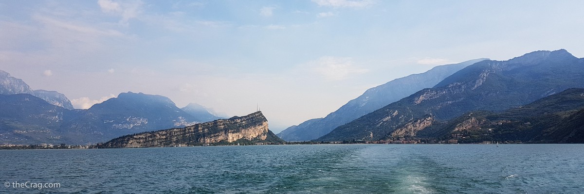
1.5. Valle del Sarca 2,941 routes in Crag
- Summary:
-
Mostly Sport climbing
Lat / Long: 46.005117, 10.946757
- mountain biking
- hiking
- sailing
- windsurfing
- kite-surfing
- sightseeing
- Note:
- The crags are sorted from Arco going to the Western side of the valley and then upstream, heading over to the Eastern side and back downstream to Arco.
summary
The Sarca Valley, stretching out north from Arco is the main climbing area in the wider region of Arco. It is complemented by many other crags just outside the valley but close to Arco.
Arco has it all, endless cliffs, Lago di Garda, a beautiful historic town with plenty of climbing shops and a long tradition of climbing, amongst them the Arco Rock Masters - simply a climber's dream.
description
The Sarca Valley (Valle del Sarca) is an outstanding climbing area north of Lake Garda (Lago di Garda). The sheer number of high rock faces, coupled with the proximity to the lake, the picturesque town of Arco and Italian lifestyle, makes the valley a great destination for many climbing holidays.
If you want to go sport climbing, however, you have to accept the popularity of the area and the associated wear and tear on the rock walls. Many routes in the well-known sectors, such as 'Massone', are already very polished. But there is so much to choose from that everyone will find something for sure.
The high walls of the valley attract with short ascents and spectacular views. Also here there is something for everyone. Whether beginner or expert, whether sport or trad climber.
Located in the valley, Arco and its wider surroundings offer a lifetime worth of vie ferrata, sport and multi-pitch climbing on limestone. While high season is from early spring to late fall, Arco offers climbing year round. Amongst the hundreds of crags in the region there is always one that is dry, sunny or shady and at the right altitude to make it a pleasant spot for your day out. The same can be said regarding grades and styles of climbing. There is enough for everyone. From beginners to top athletes, from slabs to steep overhangs, from boulders to multi-pitch climbs - you choose it!
Be aware that the area is especially popular around Easter or other holidays when many German and climbers from all over the world flock to here. While this might make it hard to find a table in your favourite pizzeria, there is always a crag that will be deserted, even during high season. Make your choice.
For rest days there are a lot of opportunities:
access issues
Many crags in the area of Arco are located on private land and the huge popularity of climbing and the resulting crowds brought it with it, that issues with land owners popped up in the past and continue to pop up from time to time. Please be sensitive to regional closures and limitations to access. Stay informed and stick to local regulations.
approach
Arco is located just north of Lago di Garda and less than 40km South West of Trento in the region of Trentino-Alto Adige / South Tyrol (Südtirol). It is easily reached either from the highway connecting Milan with Venice (West - East) or from the highway from Innsbruck (Austria) to Verona (North - South). While some crags are in walking distance from town or the camp sites, many will require you to have a car or transport.
For a detailed description on how to reach Arco by fair means visit the Ecopoint Web-Site.
where to stay
Arco is a touristy place with climbing tourists being a major group. You will find all sorts of accommodation, from camp sites to hostels, agriturismos and luxury hotels. Be aware that during high season - for example around Easter - many popular places, including camp sites, might be fully booked.
history
The history of climbing in Arco is almost as old as the history of climbing itself, at least of sport climbing. Sport climbing in Arco started in the early 1980's and often Arco, or the climbers developing and climbing in that area, set the standards. It was also in Arco that climbing competitions became popular with the first Arco Rock Masters in 1985.
1.5.1. Parete di Padaro 174 routes in Crag
- Summary:
-
Mostly Sport climbing
Lat / Long: 45.934751, 10.866715
summary
Very popular single-pitch sport climbing crag near Arco but also some longer classics.
description
Nice crag above the village Padaro near Arco. It's face is south oriented and best time is in the winter months from October to March.
approach
From Arco drive to Padaro and pass the village. Below the road makes to turns and between them there are two little parking lots. Don't park in the turns as lorries may come through. From the second turn follow the paths to the crag.
1.5.2. Le Piazzole 24 routes in Crag
- Summary:
-
All Sport climbing
Lat / Long: 45.931557, 10.860566
description
Relatively new crag bolted in 2011. Take the road toward Padaro. About 1km before the village there is a concrete path on the left heading steeply up hill with space for 3 cars to park by the main road. More cars will fit 200m downhill in a pullout, or 300m up hill at the shrine for Saint Rocco. Walk up concrete path then onto cobbled dirt track. After 15 min head right at a cairn up towards the cliff. There is a topo board at the start of the crag.
South-east facing, but the base stays in the shade for a long time due to the surrounding trees.
approach
The approach path is steep but otherwise easy to navigate and gains about 250m of altitude.
1.5.3. Mandrea 26 routes in Area
- Summary:
-
All Sport climbing
Lat / Long: 45.946147, 10.880736
1.5.4. Mappamondo 29 routes in Area
- Summary:
-
All Sport climbing
Lat / Long: 45.942811, 10.878331
1.5.5. Placche di Baone 22 routes in Crag
- Summary:
-
All Sport climbing
Lat / Long: 45.925073, 10.870973
access issues
Because of a massive rock slide in March 2021 this crag is closed until further notice. See the official emergency ordinance no. 53.
As reported by Defcon5 on 3.7.2022, the closure still exists.
1.5.6. Bus de la Stria 33 routes in Cliff
- Summary:
-
All Sport climbing
Lat / Long: 45.924799, 10.877106
description
Small cliff located among the olive trees to the right of the Placche di Baone.
approach
From Arco drive in direction of Chiarano. Still on the right go straight up passing below the fountain. Then turn left and go up to the olive grove where you park. Then continue on foot uphill towards the East. Take a small downhill path that leads to Laghel and immediately turn left towards the wall.
1.5.7. Salt de la Cavra 25 routes in Cliff
- Summary:
-
All Sport climbing
Lat / Long: 45.935688, 10.876797
approach
From Arco follow the signs for Laghel. Once you reach the white church, turn left uphill on the asphalt road and continue straight until you reach a concrete road. Park on the left at the beginning of the steep section and continue on foot to the house. Once you arrive take the path in the woods on the left which leads to a hill. There continue up to traliccio dell'Enel, pass below and on the right reach the cliff.
1.5.8. L'Orto 28 routes in Cliff
- Summary:
-
All Sport climbing
Lat / Long: 45.932399, 10.877731
description
A great mostly slabby cliff for warmer days.
approach
Drive to Lághel and park near the chapel. Hike in direction Ceniga and after a while take a left on the hiking trail for Monte Casale, stay left when you can.
1.5.9. Calvario 26 routes in Crag
- Summary:
-
All Sport climbing
Lat / Long: 45.925726, 10.884619
- Kid friendly: Wide and flat base with olive trees, a good place for kids to play. In the left part, the base is slightly inclined.
summary
Technical climbs on vertical to slightly slabby limestone with a comfortable base of the wall.
description
approach
From Arco drive in direction of Làghel. Follow the old fortress walls until you reach a Y-junction, park there.
From there hike up the left road until you see the cliff on your left. Follow the trail through the olive garden.
history
In 1987 the Italian trials were held on Ali di Pollo in order to qualify for the 1987 Rock Master competition.
1.5.10. Muro dell'Asino 47 routes in Cliff
- Summary:
-
All Sport climbing
Lat / Long: 45.929971, 10.887794
description
This is probably one of the easiest crags in the Arco region and as such is perfectly suited for beginners and those wishing to take their first leading steps. The situation is pleasant, but the rock is sometimes polished. There are picnic and washing facilities at the crag. Ideal for families.
approach
From Arco follow the signs for Laghel, behind the castle. Do not park in Laghel, it’s a small village with nearly no parking areas. There is a sign at the church asking visitors to park in Arco, all available spaces have „no parking“ signs from 0-24H. Closest parking area is „parcheggio Al Castello di Arco“((45.9240121, 10.8859069) 1,9m height restriction). From the parking area follow „Via Crucis di Laghel“. The path starts right next to the church in Laghel. On foot follow the signs taking a wide path on the right that climbs to the cross of Monte Colodri. Follow the path for 15-20 minutes and then turn left for a path with white and red marks which will take you to the base of the wall.
1.5.11. Red Point Wall 97 routes in Cliff
- Summary:
-
All Sport climbing
Lat / Long: 45.943501, 10.892162
description
An impressive cliff located above Làghel that can also be climbed on hot days.
approach
From Arco follow the road to Laghel. When you reach the little white church go straight for few km on the road that go to a Scout-camp. Park at the "parking place" close to a turn. Take the trail on the right to 'Ceniga Monte Colt', follow it for few meters and then go up left till the crag.
1.5.12. Monte Colt - San Paolo 268 routes in Crag
- Summary:
-
Mostly Sport climbing
Lat / Long: 45.940422, 10.895828
summary
The "Parete di San Paolo" is at the bottom of the valley while the "Parete di Monte Colt" forms the second level above it.
approach
"Parete di San Paolo" is easily approached from the valley, either from Arco or coming from Ceniga. "Parete di Monte Colt" can be approached from Ceniga or also coming from the other side, via Laghel. Look at the individual sectors for details.
history
The first explorer of these walls was Giuliano Stenghel who in the 80s opened some interesting routes. Later this wall was abandoned. Then, with the new wave of sport climbing, its real potential was rediscovered. The credit for this goes to Giuseppe Mantovani who created an incredible series of small jewels.
1.5.13. Massi di Prabi 60 routes in Crag
- Summary:
-
All Sport climbing
Lat / Long: 45.927598, 10.890234
description
The crag consists of boulders at the foot of the east face of Monte Colodri. After routes were opened up early on the two largest boulders (Masso A, Masso B), routes have now also been established on the many smaller boulders. The climbing is mainly on slightly angled to vertical slabs. A fitness course and a covered terrace make the area an ideal family destination.
approach
To find your way around the many blocks, there's an overview map at the entrance or here at p.26 https://issuu.com/gardatrentino/docs/2021_gt_brochure_climbing
1.5.14. Monte Colodri 112 routes in Crag
- Summary:
-
Sport climbing, Trad climbing and other styles
Lat / Long: 45.928161, 10.888266
summary
Alpine climbing in the city!
description
==[en]== Birthplace of one of the oldest climbing competitions in sport climbing, the Rockmaster, but also an impressive steep face in the immediate vicinity of the town of Arco and the river Sarce. Not far from the river campsites, you will find climbing routes of up to 300 metres in every style of climbing.
==[de]== Geburtsort von einem der ältesten Kletterwettkämpfe im Sportklettern, dem Rockmaster, aber auch eine beeindruckende Steilwand in unmittelbarer Nähe zur Stadt Arco und dem Fluss Sarce. Unweit der Campingplätze am Fluss, findet man hier Kletterrouten mit bis zu 300 Metern Länge in jeder Spielart des Kletterns.
1.5.15. Parete di Mandrea 39 routes in Crag
- Summary:
-
Sport climbing, Trad climbing and Aid climbing
Lat / Long: 45.946551, 10.885523
approach
From Arco follow the signs for Laghel. Once you reach the little white church, turn left uphill on the asphalt road and go straight on the road becomes a dirt road. Park near a wide bend to the right and then follow the tracks in the woods to reach the 'Pilastro Tibet' and 'Pilastro Poero'. While for the 'Pilastro Afghano' you have to continue a little more by car. Park at a bend to the right. Then you enter the forest following the track that climbs along the steep scree.
1.5.16. Coste Dell'Anglone 72 routes in Crag
- Summary:
-
Mostly Sport climbing
Lat / Long: 45.965300, 10.904830
summary
Coste Dell'Anglone is a long rocky band from Cima to Coste. Running towards the south, it ends above Dro and Ceniga, then joining the Mandrea wall. It holds multi-pitch routes and sport sectors.
description
It is not a very high wall, often broken, cluttered with vegetation, it does not seem to offer interesting climbing. Instead, thanks to the great work of some mountaineers, amongst them Heinz Grill, and thanks to the excellent quality of the rock, in recent years many routes have been developed on these walls.
Quite a few topos can be found on https://www.arrampicata-arco.com/coste-dell-anglone.html
The very peaceful environment and the nature of this place make it certainly worth a visit.
approach
Leave your car in the large and convenient parking in the center of the town of Ceniga, near the junction for the ancient Roman bridge or Maso Lizzone. Then follow the signs for Maso Lizzone between the houses. Once at the farm, follow the signs for the Scaloni trail (CAI white-red trail sign), shortly afterwards take a single track that branches off to the left and leads to the base of the wall near the "La Fattoria degli Struzzi" cliff. Now follow the base of the wall to the left to the various routes.
where to stay
Agriturismo Maso Lizzone.
history
Giuliano Stenghel, the first explorer of this wall, was already climbing the most logical and obvious lines in the 1980s: such as via Supernova or via Mario Centi. Then, it was abandoned. It is only in recent years, with the discovery of its sport climbing potential, that many new routes have been developed, many interesting and of great satisfaction.
1.5.17. Cima alle coste 28 routes in Cliff
- Summary:
-
Trad climbing and Sport climbing
Lat / Long: 45.979443, 10.914255
description
The cliff is also known as "Gran diedro di Dro" and in fact it looks like a giant dihedral. The cliff is split into two parts: The south face which is known for it's brittle and extreme routes and the east face (or central sector) which is much easier and accessible. Because of the good rock in the east face a lot of new routes were developed in the last years and in the lower sector 'Lo Scudo' many sport climbs were set up.
approach
Park at the Lago Bagatolli and follow the gravel road until the second turn. Then head left. For the sectors 'L'Antiscudo' and 'Guglia Solidarnosc' turn right at a boulder where Antiscudo is written. Follow the steep trail directly beneath the face. For the central sector (east face), Lo Scudo and the south face pass the boulder on the gravel road until it rises. At the end of the incline follow a path to the right.
1.5.18. Monte Brento 6 routes in Cliff
- Summary:
-
Mostly Trad climbing
Lat / Long: 45.993049, 10.912567
1.5.19. Massi di Gaggiolo 34 routes in Crag
- Summary:
-
Mostly Sport climbing
Lat / Long: 45.991523, 10.925904
approach
Park at (45.990156, 10.925846) or at (45.992375, 10.927145) but never on the private parking lot of Elias Adventure Park.
1.5.20. Placche Zebrate 86 routes in Cliff
- Summary:
-
Bouldering, Sport climbing and Trad climbing
Lat / Long: 45.999371, 10.917716
description
The sunny slabs offer mostly easier climbing on good rock with runnels and pockets. In winter sunny all day, in summer shade from early afternoon on.
Lots of bolts but bring a rack of nuts and small-med cams to protect long runouts.
1.5.21. Pala delle Lastiele 3 routes in Cliff
- Summary:
-
All Trad climbing
Lat / Long: 46.004911, 10.922070
description
Parete di roccia calcarea subito a destra della Parete Zebrata
1.5.22. Pian dela Paia 15 routes in Cliff
- Summary:
-
All Trad climbing
Lat / Long: 46.011909, 10.927572
description
1.5.23. Pietramurata 109 routes in Area
- Summary:
-
Mostly Sport climbing
Lat / Long: 46.017821, 10.935544
summary
These are the crags located near the village of Pietramurata.
1.5.24. Monte Casale 13 routes in Crag
- Summary:
-
Trad climbing, Sport climbing and Rock climbing
Lat / Long: 46.031493, 10.934353
summary
The east face of Monte Casale represents the most imposing rock structure of the entire valley. It hosts climbs of great historical value, the best ones running along vertical pillars on both sides.
description
The Monte Casale is a 1632 meter high mountain near the Lake Garda in Trentino mountains in Italy. The mountain rises with a 1400 meter high east wall above the village Pietramurata (254m) in the Sarca valley. It is the highest and most impressive wall in the valley.
approach
From Sarche in the direction of Arco turn right at the first sign for "Pietramurata". Immediately after a crossing follow the signs for the via ferrata and the Croz dei Pini trail. Park at the beginning of the trail near the gate of the big quarry. Follow the path for the via ferrata and when you get to the boulder marked "550" leave the path and traverse to the right at the base of the large cliff.
1.5.25. Sarche 270 routes in Area
- Summary:
-
Mostly Sport climbing
Lat / Long: 46.043837, 10.950692
summary
These are the crags located near the village of Sarche in the Valle del Sarca and the ones located along the lower section of the road in direction of Madonna di Campiglio, just above Sarche.
1.5.26. Maso Limarò 34 routes in Cliff
- Summary:
-
All Sport climbing
Lat / Long: 46.061052, 10.925318
description
A nice sector with slabs and overhanging routes.
approach
From Sarche drive up in direction Madonna di Campiglio. Park just before the 4th tunnel on the left, you see the cliff from there.
1.5.27. Limarock 14 routes in Cliff
- Summary:
-
All Sport climbing
Lat / Long: 46.060026, 10.913213
description
A small crag for hot days.
approach
Same as for Maso Limarò but follow the old road until you reach the crag.
1.5.28. Gola del Limarò 1 route in Area
- Summary:
-
All Sport climbing
Lat / Long: 46.059582, 10.927003
1.5.29. Bassilandia 121 routes in Cliff
- Summary:
-
All Sport climbing
Lat / Long: 46.055436, 10.959514
description
A cliff with an great view of lake Toblino and excellent climbs.
approach
From Arco head towards Trento until you reach the town of Sarche. There drive to Lake Toblino. Before reaching the castle, park on the left at the first clearing by the lake. Go up the path, climb over a large iron cable, until you reach a flat trail. Follow it to the right and at the first intersection go left until you arrive exactly under the cliff. The trail climbs steeply from there.
1.5.30. La Gola 178 routes in Cliff
- Summary:
-
All Sport climbing
Lat / Long: 46.059695, 10.963921
description
Nice cliffs in the canyon and forest, great spot for hot days.
approach
Across from the Bar Castel Toblino is an small alley with an gravel road. You can drive up the road. You can drive up the road up to any of the sectors and park at the side of the road, if the space isn't occupied jet. Do not block the road with your car!
You can also park at the main road and hike up the canyon. In a 15 minute walk you will reach the last sector.
history
Originally discovered by Roberto Bassi and Heinz Mariacher. Re-bolted in the years 2016 and 2017.
1.5.31. Santa Massenza 113 routes in Area
- Summary:
-
Mostly Sport climbing
Lat / Long: 46.069365, 10.978452
summary
The region of Santa Massenza, located at the beautiful lake, hosts multiple single-pitch sport sectors as well as some multi-pitch climbing.
approach
Drive to Santa Massenza, the crags are located just outside the village. See respective crags for details.
1.5.32. Margone 29 routes in Cliff
- Summary:
-
All Sport climbing
Lat / Long: 46.065376, 10.960725
description
Climbing on vertical and overhanging rock.
approach
Drive to Vezzano and turn left in direction of Ranzo. The cliff is above the road.
1.5.33. Coel dela Val dela Porta 25 routes in Cliff
- Summary:
-
All Sport climbing
Lat / Long: 46.066632, 10.955798
description
A remote sector with grey and yellowish rock.
approach
Same as for Margone. Once parked, continue on the road in direction of Renzo until you see atrail going up to the cliff, also using fixed ropes.
1.5.34. Ranzo 214 routes in Area
- Summary:
-
All Sport climbing
Lat / Long: 46.065810, 10.940317
summary
A couple of crags located around the village of Ranzo. Several of them are located above the canyon of Limarò while Drago Zone and Herr Wall are on the other side of the village.
approach
Leave the road from Rovereto to Arco at the village Loppio climbing some serpentines. Passing Pannone and arriving at Ranzo. Please refer to the individual crags for more details.
1.5.35. Lon 23 routes in Cliff
- Summary:
-
All Sport climbing
Lat / Long: 46.082544, 10.982630
description
A rarely visited crag just below the road. The access path was (is) used as a garbage dump and a bit overgrown. The rock is excellent but make sure to check fixed protection as salt from the street seeps in.
approach
Drive to Vezzano and there continue in direction Ranzo. Find a path near a Madonna statue. You will reach sector A first, continue for sector B.
1.5.36. Teatro delle Marionette 16 routes in Cliff
- Summary:
-
All Sport climbing
Lat / Long: 46.084496, 10.983111
description
A cliff just across the street from Lon.
approach
Visible from the parking for Lon, follow a faint trail up through the forest.
1.5.37. Castel Madruzzo 24 routes in Cliff
- Summary:
-
All Sport climbing
Lat / Long: 46.037848, 10.991966
description
A great cliff with excellent bolting.
approach
Drive towards Calavino from Lasino. Shortly after the turn off for Castel Madruzzo you will see signs for the crag.
1.5.38. Lagolo 9 routes in Cliff
- Summary:
-
All Sport climbing
Lat / Long: 46.031640, 11.002593
description
A small overhanging cliff, perfect for summer.
approach
From Arco towards Trento turn right following the signs for Drena, Valle di Cavedine. After the village of Cavedine, after 2km turn right for Lagolo, Monte Bondone. Just before the lake you can see the overhanging face. A short path leads to the base of the cliff.
1.5.39. San Siro 78 routes in Crag
- Summary:
-
All Sport climbing
Lat / Long: 46.027242, 10.971545
- Kid friendly: The sectors A has a wide base which makes it perfect for kids of all ages. Sector C also has some space which makes it good for all ages. Sektor B has some areas with some risk of falling and is therefore the least kid friendly sektor.
summary
A great crag for families and climbers up to 8a.
description
approach
Drive to Dro, turn right and go up to Drena. Continue straight for Cavedine and Stravino until you reach Lasino. As soon as you pass the "Lasino" sign, turn left onto a country road and go up to the church of S.Siro, pass it until you reach the parking lot of the cliff at this location. From there it's a 5 to 10 minute walk to the crag.
1.5.40. La Cosina 38 routes in Cliff
- Summary:
-
All Sport climbing
Lat / Long: 46.009763, 10.975692
description
A small, rarely visited carg with easy climbs.
approach
Drive to Cavedine. Once in the village, take a left and head in direction Lago di Cavedine. Park at the construction material center and follow the signs for Strada Romana and Area Archeologica.
1.5.41. Cavedine 29 routes in Cliff
- Summary:
-
All Sport climbing
Lat / Long: 46.000095, 10.962266
description
A cliff with technical climbs, great in the morning on hot days.
approach
Drive to Trebi and from there in direction Cavedine. The crag is right of the street.
1.5.42. Castello di Drena 12 routes in Cliff
- Summary:
-
All Sport climbing
Lat / Long: 45.969696, 10.938909
description
The cliff just below the castle of Drena. Steep climbing.
approach
Park near the castle in Drena.
1.5.43. Rio Sallagoni 1 route in Cliff
- Summary:
-
All Rock climbing
Lat / Long: 45.969627, 10.936328
1.5.44. Open Air Gallery Progetto 3000 1 route in Crag
- Summary:
-
All Sport climbing
Lat / Long: 45.960177, 10.935637
1.5.45. Dos Pelá 11 routes in Cliff
- Summary:
-
All Sport climbing
Lat / Long: 45.968033, 10.948574
description
Im Valle di Cavedine; direkt neben dem Straßentunnel; Picknickarea; beim PCM in der Kurve parken (Wertstoffhof); den Weg an der Straße folgen.
As family friendly as it gets in terms of approach length and difficulty (none), route length (very short), protection (a lot), anchors (locking biners everywhere), flat secured base of the wall, and even picnic benches are available.
approach
Drive to Drena, the kid and family friendly crag is in the center of the village. Access possible from both sides of the tunnel.
1.5.46. Lastoni di Dro 4 routes in Crag
- Summary:
-
All Sport climbing
Lat / Long: 45.954112, 10.920597
description
Big slabs with multi pitches at the east part of the valley near Dro. The topo shows many "SU" ("Sanduhr" / rock tunnel). MOst of these already have slings in them, but it can be helpful to have a set of spare slings available. Also the number of bolts (at least in Via dei Ciclamini) is higher than in the topo. Topos: https://www.bergsteigen.com/touren/klettern/via-dei-ciclamini-lastoni-di-dro/
1.5.47. Grottosauro 17 routes in Sector
- Summary:
-
All Sport climbing
Lat / Long: 45.944701, 10.913623
description
An intimidating and overhanging wall with excellent rock and athletic climbs.
approach
Same as for "Terra Promessa" but continue for a few hundred meters until you see a place to park the car. Follow the trail "Sentiero della mastra" down and left until you reach fixed ropes that lead to the crag.
1.5.48. Terra Promessa 56 routes in Cliff
- Summary:
-
All Sport climbing
Lat / Long: 45.941043, 10.917809
description
An overhanging cliff with huge potential for more routes and a nice view.
approach
From Arco follow the signs for Massone. Once you reach the crag continue the signs for route 9 for bicycles. At the crossing turn left for Braila and at the first hairpin bend park on the right. Follow the path on the left in the woods, once you reach a low wall keep going up to the right to reach the base of the cliff.
1.5.49. Piccola Dallas 33 routes in Cliff
- Summary:
-
All Sport climbing
Lat / Long: 45.934797, 10.903419
description
Beautiful cliff with overhanging and resistance climbs, ideal for climbing in hot weather as the northwest exposure allows you to stay in the shade until late in the afternoon. After periods of rain, the left pitches of the upper sector and the starts of the right routes of the lower sector can be wet.
approach
Park at the petrol station located on the right on the state road immediately after Moletta. The two sectors of the cliff are clearly visible from there. Hike north and go right at the first possibility, you will see a white iron fence. Climb over the fence and follwo the trail into the forest.
1.5.50. Massone 188 routes in Crag
- Summary:
-
All Sport climbing
Lat / Long: 45.929589, 10.902933
- All day sun:
- On April the sun was gone at approximately 4 pm. Some sectors are longer in the sun, others have some shade earlier.
- Kid friendly:
- At most sectors is enough space at the base of the wall for the kids to play.
summary
Very popular crag with wide range of grades and kid-friendly sectors. It also hosts the first 9a in Italy. Due to its popularity some of the routes are greasy.
description
Very popular crag with wide range of grades and kid-friendly sectors. It also hosts the first 9a in Italy.
approach
From Arco cross the bridge and take the state road 45bis to the left towards Trento. After 500m turn right and go up towards Massone, cross it and after a narrow passage under an arch turn left and go up among the olive trees towards Troiana. At the beginning of the hairpin bends are the walls on the left.
1.5.51. Falesia Family San Martino 18 routes in Crag
- Summary:
-
All Sport climbing
Lat / Long: 45.927492, 10.900187
description
Familiy-friendly crag surrounded by olive groves with short approach and very good infrastructure: toilet, shower, picnic area and a viewpoint where you can overlook Arco and see a glimpse of the Lago die Garda.
approach
Best is to arrive by bike, there is room for 20 bicycles in the bicycle stand. The street through Massone is very narrow and there are just a few parking lots at the San Martino church. From the church in few minutes to the crag.
1.5.52. Parete dell'Ir 5 routes in Cliff
- Summary:
-
All Trad climbing
Lat / Long: 45.918466, 10.916994
1.5.53. Parete di Pezol 3 routes in Cliff
- Summary:
-
All Trad climbing
Lat / Long: 45.924528, 10.913221
description
Bella parete con esposizione a sud. Calcare con classidre, buchi, placche, diedri e strapiombi.
1.6. Volta di No 44 routes in Cliff
- Summary:
-
All Sport climbing
Lat / Long: 45.930238, 10.849221
1.6.1. Settore A 10 routes in Sector
- Summary:
-
1.6.2. Settore B 14 routes in Sector
- Summary:
-
1.6.3. Settore C 18 routes in Sector
- Summary:
-
1.7. Tenno 22 routes in Crag
- Summary:
-
Mostly Sport climbing
Lat / Long: 45.955681, 10.810489
summary
Currently 2 sectors above lake Tenno.
approach
From Arco follow the signs for Valle di Ledro and Tenno and continue until you get to Hotel Lago di Tenno. Park and continue on foot towards the lake, follow the path that leads to the picnic area and then into the forest that leads to the cliff.
1.7.1. Sanderland 21 routes in Cliff
- Summary:
-
All Sport climbing
Lat / Long: 45.944669, 10.819603
approach
Drive in direction of Tenno, pass the village and park near the hotel Lago di Tenno. Follow the path along the lake and hike up the forest road to the cliff.
1.7.2. Via Ferrata Signora delle Acque 1 route in Area
- Summary:
-
All Rock climbing
Lat / Long: 45.966560, 10.802051
1.8. La Ponta 17 routes in Crag
- Summary:
-
Mostly Sport climbing
Lat / Long: 45.877169, 10.838199
summary
Less frequented low-altitude crag with views on lake Garda
description
A former alpine training ground, this area has been reequipped with bolts and now offers some pleasant climbs somewhat above the shore of lake Garda.
approach
From Riva, follow signes towards "Limone". It is safest to leave the car in the park house just after the tunnel. You may take a chance an continue for another 500 m, but parking there seems mostly restricted or is occupied. After the hydropower station (huge pipes from uphill), the old Ponale road (closed for cars) branches off, while the road to Limone continues through a tunnel. Walk ~200 m along the old Ponale road just before its first tunnel. There, opposite an info-board, a narrow trail leads right and uphill. After 3 min you reach the cliff.
Check http://www.openstreetmap.org/relation/46276#map=18/45.87805/10.83847
1.8.1. Left sector 10 routes in Sector
- Summary:
-
All Sport climbing
Lat / Long: 45.877052, 10.838188
description
The more mainstream choice
1.8.2. Right sector 7 routes in Sector
- Summary:
-
Mostly Sport climbing
Lat / Long: 45.877235, 10.838207
description
Less routes, more searching, more adventure.
1.9. Parete Serenella 12 routes in Cliff
- Summary:
-
Mostly Deep water soloing
Lat / Long: 45.871492, 10.837461
description
Attention: climbing above the water can be dangerous. It is recommended to bring a life vest. Never go DWS alone.
approach
Arrival: From Arco go in the direction of Riva del Garda. At the rounabout in Riva turn towards Rovereto/Torbole. Go through Riva intil you reach the fire station. Park on the opposite side of the road on a gravel square. Approach: Go along the pedestrian walk in the direction of Punta Lido. From here, continue with a pedal boat. The wall is located on the right side of the lake, near the Ponale road.
1.10. Rock & Wall 15 routes in Cliff
- Summary:
-
All Sport climbing
Lat / Long: 45.865682, 10.821249
description
This is a newly equipped crag. Unfortunately the routes below are not listed in correct order. But the names of some routes are written to the rock.
approach
Parking site (45.86443, 10.812307) next to the road from Riva del Garda to Ledro. Walk trough tunnel (45.865547, 10.818773) to Strada del Ponale. Pass waste bins area (parking there will be fined regularly) then turn left onto steep trail (45.8652603, 10.8207565). Go left on first fork. Walk steep up to hiking trail, go right just a few metres (direktion of Defension Wall/Riva). You'll easily find the crag (45.8655405, 10.8213573) to your left.
1.11. Regina del Lago 93 routes in Crag
- Summary:
-
Mostly Sport climbing
Lat / Long: 45.865639, 10.817172
summary
Sunny crag with single and multi-pitch routes and vistas of Lake Garda on the north side of the Ponale gorge. Not recommended for hot days.
description
in Italian: http://www.arrampicata-ledro.it/arrampicata_Ledro.htm
Wear a helmet, also when just lingering at the base! Activity on adjacent climbs, uphill sectors or hiking paths often releses rockfall!
approach
From Riva, follow signs towards "Valle di Ledro" through long tunnel (5 km). 200 m after the tunnel, there are parking bays left and right of the road. Walk back towards the mouth of the tunnel and turn right into the old Ponale road and through an old tunnel. After 200 m there is a stone wall supporting the left slopes. Where it ends, the path to the sectors start.
Do not park on the large paved section on the right side of the highway after the tunnel... 40 EUR fines are regularly given.
Check http://www.openstreetmap.org/#map=17/45.86491/10.81826
1.11.1. Sector A 23 routes in Sector
- Summary:
-
Mostly Sport climbing
Lat / Long: 45.864977, 10.827688
description
Most uphill sector
approach
From the small parking after the tunnel, take the path that starts at the right side of the embankment wall. Follow the red-and-white signs switchbacking uphill and atop the prominent overhanging cliff (ca. 15 min). Turn left (steep uphill) at next junction (cairn, faint markings) for 10 more minutes to base of cliff.
OSM-Map will help: http://www.openstreetmap.org/#map=17/45.86445/10.82647
1.11.2. Sector B 15 routes in Sector
- Summary:
-
All Sport climbing
Lat / Long: 45.864356, 10.826764
description
Long inclinated rock face with patches of vegetation comprising sectors B, C and D.
approach
Long inclinated rock face with patches of vegetation comprising sectors B (left), C and D (right).
1.11.3. Sector C 17 routes in Sector
- Summary:
-
All Sport climbing
Lat / Long: 45.864139, 10.827759
description
Long inclinated rock face with patches of vegetation comprising sectors B (left), C and D (right).
approach
From the small parking after the tunnel, take the path that starts at the right side of the embankment wall. Follow the red-and-white signs switchbacking uphill and atop the prominent overhanging cliff (ca. 15 min). Continue along contour and look for small turnoffs left leading to sectors B (some scrambling), C and later D along the path.
OSM-Map will help: http://www.openstreetmap.org/#map=17/45.86445/10.82647
1.11.4. Sector D 4 routes in Sector
- Summary:
-
All Sport climbing
Lat / Long: 45.863919, 10.828796
description
Long inclinated rock face with patches of vegetation comprising sectors B, C and D.
approach
Long inclinated rock face with patches of vegetation comprising sectors B (left), C and D (right).
1.11.5. Sector E 5 routes in Sector
- Summary:
-
All Sport climbing
Lat / Long: 45.864030, 10.830617
description
Cave-like sector tucked away in a ravine.
approach
Continue along path past sector D for another 10 min.
1.11.6. Prima Fascia 5 routes in Sector
- Summary:
-
All Sport climbing
Lat / Long: 45.864261, 10.825853
description
prominent overhanging face facing SW
1.11.7. Seconda Fascia 19 routes in Sector
- Summary:
-
Sport climbing, Trad climbing and Rock climbing
Lat / Long: 45.863395, 10.828447
description
Long wall looming over the Ponale road. Photo topo
1.11.8. Cima al Bal 1 route in Sector
- Summary:
-
All Sport climbing
Lat / Long: 45.862312, 10.814651
1.12. Muro dei caprioli 64 routes in Crag
- Summary:
-
All Sport climbing
Lat / Long: 45.869295, 10.805190
1.12.1. Superdonne 7 routes in Sector
- Summary:
-
1.12.2. Principale 18 routes in Sector
- Summary:
-
Lat / Long: 45.869599, 10.808017
1.12.3. Teatro per caso 7 routes in Sector
- Summary:
-
Lat / Long: 45.869240, 10.808784
1.12.4. Clandestino 5 routes in Sector
- Summary:
-
1.12.5. Capitello 20 routes in Sector
- Summary:
-
Lat / Long: 45.870390, 10.804464
1.12.6. Il Muretto del Vento 7 routes in Sector
- Summary:
-
Lat / Long: 45.867876, 10.802461
1.13. Nodice 2 routes in Area
- Summary:
-
All Sport climbing
Lat / Long: 45.856267, 10.823932
1.14. Finale Ampola 37 routes in Crag
- Summary:
-
All Sport climbing
Lat / Long: 45.862658, 10.645102
summary
Finale Ampola, as well as Futur Ampola are not far from lake Ampola in the Ledro valley. Finale Ampola is a great cliff for beginners and families.
1.14.1. Sector Principale 27 routes in Sector
- Summary:
-
1.14.2. Sector A 3 routes in Sector
- Summary:
-
1.14.3. Sector Feudo 7 routes in Sector
- Summary:
-
1.15. Val Concei 12 routes in Crag
- Summary:
-
All Sport climbing
Lat / Long: 45.925539, 10.718655
summary
Two small but beautiful crags above the Lago di Ledro at about 1000m altitude
1.15.1. Pizzocol 8 routes in Cliff
- Summary:
-
Lat / Long: 45.926221, 10.717209
description
1.15.2. Al Coel 4 routes in Cliff
- Summary:
-
Lat / Long: 45.925035, 10.720042
description
In an altitude of about 950 m in idyllic and wooded "Valle dei Molini"
approach
There are 3 marked parking spots opposite the crag.
1.16. Futur Ampola 27 routes in Crag
- Summary:
-
All Sport climbing
Lat / Long: 45.858413, 10.636643
summary
Relatively recent addition to the climbing in Arco in the Ledro valley not far from the lake Ampola.
description
Nice vertical and overhanging limestone routes. The cliff faces east and is ideal for summer afternoons and evenings.
approach
Drive into the Ledro valley and pass lake Ampola and the turn-off to Tremalzo. Park just in front of the bridge crossing the river Palvico on the left side. Cross the road and hike up to the cliff.
1.17. Nago 411 routes in Area
- Summary:
-
Mostly Sport climbing
Lat / Long: 45.871358, 10.897641
summary
The crags located around the town of Nago. Many family friendly crags with great views.
approach
Make your way from Arco to Nago. See individual crags for details.
1.17.1. Belvedere 58 routes in Crag
- Summary:
-
All Sport climbing
Lat / Long: 45.880771, 10.887814
summary
Great view of Lago di Garda from an often busy crag.
access issues
The guide book access has been changed. Do not park on the arco-Nago roadside. There is a large parking area (45.878839, 10.889349) at the major Nago roundabout. The path leads uphill if you walk out the west side of the car park. There is a signboard, red dots and crag information. the path meets the crag between sectors 1 and 2 and all routes are numbered as per the free tourist office brochure "climbing".
1.17.2. Parete Dos Casina 6 routes in Area
- Summary:
-
All Trad climbing
Lat / Long: 45.861602, 10.890532
summary
Parete Dos Casina is a long rocky wall averaging 100m tall. It is a very wild climbing area for Arco's standards - mostly naturally protected chimney and crack climbing with an airy feel.
description
It is located on the west side of Monte Altissimo. It is located just below the Malga Zures area (known for a massacre of partisans by the Nazis in the last world war).
ethic
Trad
1.17.3. Falesia Segrom 139 routes in Crag
- Summary:
-
Mostly Sport climbing
Lat / Long: 45.867201, 10.897630
summary
Short approach, wide grade spectrum, many routes, safe for kids - what more could you want? (except solitude)
description
Large cliff southeast of Nago.
Topos at http://www.planetmountain.com/english/Rock/crags/falesia.html?idfalesia=89
approach
Coming from Arco, follow the main road through Nago (don't go into the old centre of town as some guidebooks suggest - the streets are unnervingly narrow). Lower sectors (A-C): When the buildings get less dense, follow a small road to the right for "Monte Baldo" for ca. 1 km. At a small chappel, turn left into a narrow road and continue till its and in a small parking area. Expect this to be full, so park earlier, and walk in, if possible. Higher sectors can easier be reached when passing the chappel and continueing for another 2 km to a parking area at a hairpin bend to the left
1.17.4. Le Trincee 76 routes in Area
- Summary:
-
All Sport climbing
Lat / Long: 45.868018, 10.899888
summary
Le Trincee is located inside a canyon right above Falesia Segrom. It offers technical climbing on vertical limestone and some more athletic climbing on overhanging terrain.
description
Le Trincee has has been discovered by Mauro Trainotti in 2018. Mauro bolted it along with Andrea Vecchi, Domenico Tonelli, Carlo Bona, Roberto Avanzini and Loris Manzana. As of april 2023, there are around 70 routes divided between the different sectors. All sectors are very close to each others. Names and grades are marked under every route, if the grade is missing, the route hasn't been freed yet. The crag is perfect during spring and summer as it's always in the shades
approach
Best thing you can do is follow the gps location. The access is the same as for Falesia Segrom.
Or if you are old school, coming from Arco, reach Nago along the highway SS240 direction Rovereto, at the Nago roundabout continue straight, pass the "Hotel Rubino", and a bit after the traffic light turn right into a country road, pass thorough the vineyards and follow the road uphill. Keep driving till you reach the parking spot in front of falesia segrom.
From here continue on foot up the path to "falesia segrom" (there are sigs and pictures at the entrance), once at this crag, start walking towards the left on a stair-path. Once the stair path begins going downhill, go right instead (uphill). There should be a few ropes helping you on the steeper part of the hike. Careful cause it can be pretty slippery and it's easy to step on rocks that could eventually roll down to the lower sectors. You'll soon reach a gravel path. walk towards the left. After 20-30 meters go right uphill inside the woods (it's not so obvious but I guess you can get to the crag pretty much if you turn right at any time). From here you'll get to the canyon within few minutes.
I've heard there's an easier path to the crag but I haven't tried myself, if someone knows it, please update the approach
1.17.5. Massi delle Traole 67 routes in Crag
- Summary:
-
Mostly Sport climbing
Lat / Long: 45.867508, 10.894761
summary
A boulder field in front of the 'Falesia Segrom'. Established by the local community for families. Easy approach, flat terrain and short routes.
description
Developed and maintained as part of the project "Outdoor Park GardaTrentino". Mostly family and kid friendly routes but also some hard test pieces.
approach
Park at 45°51'54.6"N 10°53'44.3"E. This is the upper car park of 'Falesia Segrom'. The boulders are in north-west direction. Use the hiking trail in direction north (down hill, starts at the next bend of the road).
history
Officially opened in 2017.
1.17.6. Marmitte dei Giganti 22 routes in Cliff
- Summary:
-
All Sport climbing
Lat / Long: 45.879051, 10.884277
description
A cliff with a great view, the lower section is great for families.
approach
From Arco, follow the signs for Nago-Rovereto, taking the SS 240 state road to the right of the bridge over the Sarca river. Once in Nago, go through the roundabout and go back towards Torbole. After a few meters near a large bend park on the right (panoramic point). From there, walk down the path to the Marmitte dei Giganti.
1.17.7. Passo San Giovanni 42 routes in Crag
- Summary:
-
Mostly Sport climbing
Lat / Long: 45.873939, 10.910211
approach
From Arco, follow the signs for Nago-Rovereto, taking the SS240 state road to the right of the bridge over the Sarca river. Once you reach Nago, pass the traffic light and continue straight uphill to Passo San Giovanni. Park on the right in the parking lot in front of the restaurant (2022: only a construction site). On foot cross the road and go down the cycle path following the obvious signs for the cliff.
A way leads up to the sectors, next to a huge construction site. Climbing still possible, but some noise during working days
1.18. Torbole 26 routes in Area
- Summary:
-
All Sport climbing
Lat / Long: 45.857163, 10.870842
approach
Parking: (45.8566301, 10.8704677)
then back to the tunnel and through the first or second tunnel window depending on which sector you want to reach.
1.18.1. Torbole Sector 9 routes in Sector
- Summary:
-
Lat / Long: 45.857036, 10.870856
approach
Parking: (45.8566301, 10.8704677)
then back to the tunnel and through the first tunnel window and follow the path up left.
1.18.2. DWS Sector 17 routes in Sector
- Summary:
-
Lat / Long: 45.857392, 10.870869
description
Second sector with shorter routes.
approach
From the parking go back into the tunnel, but do not take the first opening to the lake as you would for the first sector. Instead go on and go through the second opening.
1.19. Scivolo delle Marocche 4 routes in Cliff
- Summary:
-
All Sport climbing
Lat / Long: 45.861947, 10.879404
description
A slab just above Torbole. Excellent for beginners.
approach
From Torbole, head towards the historic center and then turn left towards the Parco delle Busatte (sign). Follow the narrow road to a hairpin bend where you can already see the grey slabs. Park there.
Continue briefly on the paved road until you reach the Sentiero dei Paloni on the right (signpost). Follow it and out of the woods and enter the area of the Marocche; after a few meters you turn right along a track in the woods, with not very visible orange and blue marks, which soon lead to the base of the wall.
history
The routes have been bolted by Eugenio Cipriani.
1.20. Spiaggia delle Lucertole 19 routes in Crag
- Summary:
-
All Sport climbing
Lat / Long: 45.848349, 10.863130
summary
A really classic sector with lots of history. Slabs just above the lake might make you sweat considering the grade ...
description
It's a piece of climbing history. A lot of very old school routes.
Please respect the place and the environment !
access issues
The crag is just on the lakeside. Only a few routes are on the ground. Consider this if you don't want to have a we rope after climbing ...
approach
Coming from Torbole, exiting the "Corno di Bo" tunnel, descend on the lakeside.
where to stay
Torbole and Nago
ethic
Please brush the holds after your climbs and leave no traces.
history
Firstly bolted in 1983 by Roberto Bassi, Heinz Mariacher and Manolo Zanolla
1.21. Corno di Bo 10 routes in Cliff
- Summary:
-
All Sport climbing
Lat / Long: 45.849451, 10.863882
description
Long slabs above the lake.
Topo.
approach
From Arco reach the town of Torbole and continue on the Eastern Gardesana towards Malcesine-Verona. After about 2 km, take the second tunnel towards Malcesine. The crag can be seen immediately because it overlooks this gallery. At the bottom of the gallery on the right is a small parking area which can accommodate a maximum of 3 cars.
1.22. Torbolino 5 routes in Cliff
- Summary:
-
All Sport climbing
Lat / Long: 45.845183, 10.863389
description
A small crag left and right of the tunnel.
approach
From Arco reach the town of Torbole and continue on the Eastern Gardesana towards Malcesine-Verona. After about 3km, take the third tunnel towards Malcesine. Outside the gallery on the left is the parking lot. Here and at its side are the four routes of the Torbolino cliff.
1.23. Tassilandia 54 routes in Crag
- Summary:
-
All Sport climbing
Lat / Long: 45.884219, 10.908065
summary
A relatively recent addition with great views of Lago di Garda and sunny exposure.
1.23.1. Boscaiolo 16 routes in Sector
- Summary:
-
1.23.2. Bellavista 19 routes in Sector
- Summary:
-
1.23.3. Panta Rei 19 routes in Sector
- Summary:
-
1.24. Narango 14 routes in Crag
- Summary:
-
All Sport climbing
Lat / Long: 45.887623, 10.915562
summary
Routes not sorted correctly!
approach
Location might not be correct!
1.25. Rovereto 1,099 routes in Area
- Summary:
-
Mostly Sport climbing
Lat / Long: 45.894953, 11.055750
summary
Located not far from Arco and easily reachable via the pass San Giovanni Roverto offers multiple crags, mostly for cooler days.
description
These cargs are located in the vicinity of Rovereto, in and around the Val d'Adige.
approach
Conviniently located along the Brenner highway or a short drive over from Arco.
1.25.1. Nomesino 32 routes in Crag
- Summary:
-
All Sport climbing
Lat / Long: 45.867700, 10.952305
summary
A popular crag with a short approach, climbable all year. Ideal for families with children, because you park next to the wall, and under the cliff there is a large lawn.
approach
From Arco head towards Rovereto. Go past the town of Nago, until you reach Loppio. Immediately after the church turn left on the S.S.88 for the Val di Gresta. Continue uphill along the hairpin bends and at the crossing for the town of San Felice go straight in the direction of Ronzo, turning immediately right towards Manzano-Nomesino. Continue leaving the village of Manzano on the right and shortly after the first tunnel, turn left uphill on a steep and narrow road that will take you to the base of the cliff.
1.25.2. La Kripta 13 routes in Cliff
- Summary:
-
All Sport climbing
Lat / Long: 45.870371, 10.970003
description
A small crag just outside of Nomesino.
approach
Drive from Manzano in direction of Nomesino, just after the village park here (45.8685, 10.9714) and hike up on the left through the forest.
1.25.3. Ronzo Chienis 73 routes in Cliff
- Summary:
-
All Sport climbing
Lat / Long: 45.896480, 10.956285
description
The crag is located in a very peaceful place. The routes are quite well equipped, but the grades are rather severe. Beware of stones falling from above.
Attention (as of October 2023): The area is not maintained. Several entrances are overgrown, the lower bolts have been removed in some routes. All protections are older and the durability is questionable.
approach
From Arco head towards Rovereto. Go past the town of Nago, until you get to Loppio. Immediately after the church turn left on the S.S.88 for the Val di Gresta. Continue uphill along the hairpin bends and at the crossing for the town of S.Felice go straight on. After the tunnel you reach Pannone and always straight on you reach Ronzo Chienis. The crag is located just outside the village on the road that leads to Passo Bordala.
1.25.4. Mori 107 routes in Cliff
- Summary:
-
Sport climbing, Rock climbing and Bouldering
Lat / Long: 45.852012, 10.978162
approach
Exit Rovereto south and then follow the directions for Mori.
1.25.5. Besagno 33 routes in Crag
- Summary:
-
All Sport climbing
Lat / Long: 45.838144, 10.964194
summary
A not very frequented crag for hot days.
1.25.6. Piste Dei Dinosauri 55 routes in Crag
- Summary:
-
All Sport climbing
Lat / Long: 45.843517, 11.031743
summary
A beautiful crag, well suited for cooler but sunny days. Named after the dinosaur foot imprints found nearby.
1.25.7. Palestra di Roccia Crosano 78 routes in Crag
- Summary:
-
All Sport climbing
Lat / Long: 45.814607, 10.986478
summary
Very nice place, ideal in winter given the exposure, well-kept lawn for picnics a few tens of meters of the walls...
1.25.8. La Campana 60 routes in Cliff
- Summary:
-
All Sport climbing
Lat / Long: 45.877286, 11.047100
description
A small crag located in a dense forest with mostly vertical rock.
approach
From Rovereto drive up in direction of Porte di Trambileno. Continue on the small road straight in the last hair pin turn and park here (45.87838, 11.04508).
1.25.9. Noriglio 117 routes in Crag
- Summary:
-
All Sport climbing
Lat / Long: 45.889329, 11.059453
access issues
This crag is on private land and access has been closed in the past, at least for some sectors. Please check if climbing is allowed before you go!
approach
Park next to the petrol station in Noriglio. Follow via Campolongo up for a hort distance and take the path to the left towards the crag.
1.25.10. Eremo di San Colombano 69 routes in Crag
- Summary:
-
All Sport climbing
Lat / Long: 45.879433, 11.063684
summary
A couple of sectors at 2 different locations just above San Colombano with a lot of history (and some older bolts).
description
Sector A is located on the other side of the bridge while all other sectors are located along the main cliff.
1.25.11. Acheni 13 routes in Cliff
- Summary:
-
All Sport climbing
Lat / Long: 45.840412, 11.077526
description
A small crag located near Eremo di San Colombano.
1.25.12. Zengio del Far Noter 40 routes in Cliff
- Summary:
-
All Sport climbing
Lat / Long: 45.882364, 11.110729
description
A steep and tall wall.
1.25.13. Serrada 79 routes in Crag
- Summary:
-
All Sport climbing
Lat / Long: 45.886507, 11.157337
summary
A crag with most climbs in the 6th French grade
description
Great location at 1200m altitude, suitable for warmer days, but still mostly sunny. Structured, vertical walls with reachy moves dominate. There seem to be some chipped holds here and there at the starts of routes, but they do not diminish their general beauty. Friendly bolting with expansion bolts, never run-out.
approach
Park next to the restaurant Cogola and hike up behind the restaurant along the marked trail.
1.25.14. Cola Grant 36 routes in Cliff
- Summary:
-
All Sport climbing
Lat / Long: 45.936693, 11.114499
approach
From Rovertero head in direction Trient until you reach Besenello. Drive in direction of the castle Beseno and park here (45.9359, 11.1136).
1.25.15. L'Orrido 30 routes in Cliff
- Summary:
-
All Sport climbing
Lat / Long: 45.925510, 11.130159
description
A cliff just above a roaring river and not far from the road - quite noisy but a great place for hard movers.
approach
Park here (45.8685, 10.9714) and hike back to the canyon through the tunnel. Climb down metal stairs and fixed ropes to reach the cliff.
1.25.16. Pian del Levro 30 routes in Crag
- Summary:
-
All Sport climbing
Lat / Long: 45.851975, 11.091648
description
Ottima nelle calde giornate estive. I tiri sotto il 6a sono chiodati e pensati per far arrampicare anche arrampicatori alle prime armi. Su alcuni tiri indispensabili le corde da 70m.
approach
Parcheggiare presso ponte dell´Orco
history
Falesia chiodata nel 2006-2007 dalla Guida Alpina Giorgio Nicolodi ed altri
1.25.17. Lizzana 43 routes in Field
- Summary:
-
All Bouldering
Lat / Long: 45.867716, 11.046662
1.25.18. Marco 64 routes in Field
- Summary:
-
All Bouldering
Lat / Long: 45.847127, 11.015157
summary
Essential info is provided on the poster available at https://www.trentinoarenaexperience.it/vallagarinaexperiencefestival/boulder-park-dantesco.
1.25.19. Busa dei Galai 51 routes in Crag
- Summary:
-
Mostly Sport climbing
Lat / Long: 45.847663, 11.045365
summary
Slabs and slightly overanging walls on good gray limestone.
description
approach
From the town of Porte di Trambileno (Rovereto, TN), reach the fraction of Albaredo and, from there, take the road for Malga Tof and Monte Zugna. You will reach a series of four hairpin turns, park on the side of the road at the first one (45.846984, 11.047830). From there, a path going downward reaches the crag in 5-10 minutes.
1.25.20. Falegnameria 76 routes in Crag
- Summary:
-
All Sport climbing
Lat / Long: 45.793293, 10.993180
1.26. Trento 1,196 routes in Region
- Summary:
-
Mostly Sport climbing
Lat / Long: 46.152775, 11.188986
summary
Trento is located in the Adige valley (Etschtal) and the capital of the autonomous province of Trento (Trentino). It is at the heart of the Dolomites and a climbing mecca.
description
Trento on theCrag covers climbing areas in the surroundings of the city of Trento. Refer to "Valle del Sarca" and Valli Giudicarie for the major climbing areas located Southwest of it and Rovereto for the crags further South in the Adige valley.
approach
The Trento area is located along the Adige valley (Etschtal) and along the Brenner highway connecting Innsbruck to Verona and thus easily reachable.
1.26.1. Mezzoluna 11 routes in Cliff
- Summary:
-
All Sport climbing
Lat / Long: 46.222091, 11.129162
description
A relatively young crag above Mezzocorona.
approach
Drive to Mezzocorona and follow the signs for Monte di Mezzocorona. Park near the cable car. Follow the path upwards to the cliff.
1.26.2. Zambana 66 routes in Crag
- Summary:
-
Mostly Sport climbing
Lat / Long: 46.137763, 11.073619
summary
A historic crag with vertical and slightly overhanging climbing. The central area also offers some Dry Tooling.
approach
Make your way to Zambana and park near the water reservoir.
1.26.3. Laghi di Lamar 10 routes in Cliff
- Summary:
-
All Sport climbing
Lat / Long: 46.132215, 11.063397
description
A small cliff near the lake (Lamarsee / Lago di Lamar). Great for hot days and easy climbs.
approach
From the car park, walk along the path that runs alongside the lake (keeping the lake on the right) until the end of the lake itself.
1.26.4. Prada 22 routes in Cliff
- Summary:
-
All Sport climbing
Lat / Long: 46.128067, 11.046480
description
A tall cliff above the village of Monte Terlago.
approach
Drive to Monte Terlago. Pass left of the church until you reach a gravel parking lot (46.113942, 11.039236).
1.26.5. Lamar 16 routes in Cliff
- Summary:
-
All Sport climbing
Lat / Long: 46.117423, 11.055618
description
A great crag for hotter days on slightly overhanging and vertical rock.
approach
Drive in direction of Laghi di Lamar and park just before Lago Santo (first lake) at the picknick area. Hike up right to the cliff.
1.26.6. Terlago 44 routes in Crag
- Summary:
-
All Sport climbing
Lat / Long: 46.105500, 11.050498
summary
A great cliff with a great view, also suitable for cold and sunny days. The crag is split in three sectors.
approach
Make your way to Terlago and park near the church. Hike out of the town and up to the cliff.
1.26.7. Monte Terlago 32 routes in Cliff
- Summary:
-
All Sport climbing
Lat / Long: 46.117144, 11.036750
description
A nice cliff with more potential for long routes. The upper section has slightly overhanging routes. Some routes are long and require a good dose of courage between bolts. The lower section is completely different with routes from 15 to 30 meters.
approach
Same as for "Prada" (46.113942, 11.039236). Take the left road to reach the cliff.
1.26.8. Cantòn 11 routes in Cliff
- Summary:
-
All Sport climbing
Lat / Long: 46.115423, 11.034248
description
Technical climbing on vertical and slabby rock.
approach
Same as for "Monte Terlago", follow the road further to the left to reach the cliff.
1.26.9. Covelo 10 routes in Cliff
- Summary:
-
All Sport climbing
Lat / Long: 46.099965, 11.014522
description
A small cliff just above the village of Covelo.
approach
Drive to Covelo and park there. Most likely you can already see the cliff.
1.26.10. Vigol 8 routes in Cliff
- Summary:
-
All Sport climbing
Lat / Long: 46.085135, 11.032651
description
A small cliff in the forest near Terlago.
approach
Drive to Vigolo Baselga and park near the hotel San Leonardo. Hike down across the fields and up into the forest.
1.26.11. Baselga 17 routes in Cliff
- Summary:
-
All Sport climbing
Lat / Long: 46.073582, 11.032437
description
Technical climbing on slabs and verical rock.
approach
Drive to Baselga del Bondone and park on the Southwest side of the village. Follow the obvious trail to the cliff.
1.26.12. Bus de Vela 41 routes in Crag
- Summary:
-
All Sport climbing
Lat / Long: 46.082845, 11.073218
summary
A cliff for the hard movers! Many routes in the grade 8b and harder on excellent limestone.
access issues
Do NOT park next to the restaurant or cross private property!
approach
From Cadine drive towards Forte di Cadine / Bus de Vela and park near the roundabout. Pass next to the castle and follow the path uphill and then down to the cliff.
history
Discovered by Valerio Ballardini who bolted most routes. Others were bolted by Gabriele Moroni, Rolando Larcher and Max Faletti.
1.26.13. La Vela 129 routes in Crag
- Summary:
-
All Sport climbing
Lat / Long: 46.090969, 11.089941
summary
La Vela is one of the oldest and most popular cliffs in Trento. Proximity to the city and short approaches make it a popular after-work crag.
description
The rock is a white limestone, with notches and holes; climbing is mainly vertical or slightly overhanging. Some routes do go beyond roofs and overhangs.
approach
From the Trento Centro motorway exit (Parking Area Zuffo), take the roundabout and follow the directions for la Vela. Go past the village and keep going straight along a newly built road (northbound). Continuing, on the left, you will notice, beyond the orchards, the evident walls. Continue until you reach some neglected houses. Leave the car and walk to the left (south direction) along the old road until you reach the cliffs.
1.26.14. Schizzolandia 18 routes in Cliff
- Summary:
-
All Sport climbing
Lat / Long: 46.083693, 11.096613
description
Located just next to La Vela on private land.
approach
Same as La Vela.
history
Initial development by Andrea Gessini ("Schizzo").
1.26.15. Vason 17 routes in Cliff
- Summary:
-
All Sport climbing
Lat / Long: 46.040316, 11.055391
description
At an altitude of 1650m. Ideal cliff in summer, also well suited for beginner and intermediate climbers.
A short via ferrata, a cableway and a Tibetan bridge were also set up, the latter to be used in the presence of mountain guides only. The via ferrata allows you to easily climb to the tops and setup toprope climbs.
approach
Drive to Cavedine. After the village of Cavedine, after 2km turn right for Lagolo, Monte Bondone. Drive up to Vason, go downhill for 200m, until you reach the hotel Montana by turning left into a large parking lot. Continue on foot following the clear signs that lead to the cliff.
1.26.16. Piazzo 31 routes in Field
- Summary:
-
All Bouldering
Lat / Long: 46.185330, 11.247771
summary
Any info is provided in the free guidebook available at http://www.satcembra.it/?page_id=1165.
access issues
Few parking lots are available along the narrow country road. The boulder area is located in an accessible but private terrain, please behave properly.
1.26.17. Al Prà 53 routes in Crag
- Summary:
-
Mostly Sport climbing
Lat / Long: 46.201502, 11.252593
summary
Sport and trad routes in an idyllic environment.
description
Well-developed crag in a remote valley with two sectors on good porphyry rock. Relatively short routes in a sector east of the road and a sector with multi-pitch routes up to 40 meters. Route names are painted to the base of the wall and the ground has been levelled.
access issues
Parking is limited. Please do not park on private property or obstruct the road.
approach
Drive to Faver where you turn in direction of Segonzano. After a bridge take a left in direction of Piazzo, pass the village and park next to a BBQ area.
1.26.18. Muro di Valcava 23 routes in Crag
- Summary:
-
All Trad climbing
Lat / Long: 46.200329, 11.318311
summary
Small porphyry vertical wall. Exclusively trad. Several crack routes from 5b to 7c.
1.26.19. Rizzolaga 37 routes in Crag
- Summary:
-
Mostly Sport climbing
Lat / Long: 46.151584, 11.268679
description
Two small cliffs well suited for beginner and intermediate climbers.
approach
Drive to Campologno and Park near the gas station. Alternatively, drive to Rizzolaga and park near the church.
1.26.20. Monte Calisio 171 routes in Crag
- Summary:
-
Mostly Sport climbing
Lat / Long: 46.094120, 11.151764
summary
Panoramic view overlooking Trento, Monte Bonone and Adige Valley.
description
This crag has four excellent vertical sectors (in some parts wonderful) yellow and gray limestone dotted with edges and holes. Calisio, recently re-bolted, is the main sector and the one where it is really worth dwelling. Drago Nascosto a minor sector and offers climbs with an ancient flavor. Lo Scudo and Feudo are 2 smaller sectors.
The climbing required on Monte Calisio is technical, and mostly requires endurance and finger strength. At the cliff the terrain is very comfortable although the access doesn't look like that.
approach
The starting points for access to the Calisio cliffs are two refuges, Rifugio Calisio and Rifugio Campe (both now closed) which are reachable by car.
From these shelters you can quickly reach all the cliffs except "Il Finestron" which is reached via Civezzano.
Access to Rifugio Calisio (For West Monte Caliso):
From Trento Centre SS47 Take the ring road of Valsunga towards Padova and after 4.5 km exit right before the tunnel (exit no. 10 Trento East) then continue for 1 km and exit right to Martignano, Montevaccino. From Martignano and follow signs to Montevaccino and then to Rifugio Calisio (dirt road).
Access to Rifugio Campel (For South Monte Calisio):
From Trento center take the ring road SS47 Valsugana towards Padova and in 4.5 km take exit right before the tunnel (exit no.10 Trento East) then continue for 2.2 km and at the roundabout take the second exit for Cognola. Continue 1 km and reach the Cognola roundabout.
At the roundabout take the second exit towards Civezzano and continue until Villamontagna. At the roundabout go up Via Campel and continue to a junction with a large marble cross, follow a road to the left for the Refuge Campel. Once you arrive at the refuge, continue another 100 meters up to a large parking lot.
Access to Civezzano (For Finestron Crag):
From Trento Centre take the ring road SS47 Valsugana towards Padova and in 4.5 km exit right before the tunnel (exit no. 10 Trento East) Continue for 2.2 km and at the roundabout take the second exit for Cognola. After 1 km you arrive at roundabout Cognola, take the second exit signposted to Villamontagna - Civezzano. After 1.5 turn right on the SP17 and reach of Civezzano. From the first roundabout turn left and continue for 100 meters to the Town Hall where you can park.
Walk down the road to the left of the car park and reach the street below, follow it to the right for 10 meters and then take the path that climbs to the left between the houses, after 5 minutes take a path on the right (sign) that will quickly take you to the first sector of the cliff.
(From Trento Falesie guidebook by Alessio Conz)
history
Mount Calisio (1,097 m) is also called Argentario because it once housed important silver mines (argento is Italian for silver). The area has been affected by the 1915-18 war fortifications, some of which you can visit. Mount Calisio has various hiking trails and waking baths and in recent years several cliffs with excellent exposure have been developed.
(From Trento Falesie guidebook by Alessio Conz)
1.26.21. Ferrovia 12 routes in Cliff
- Summary:
-
All Sport climbing
Lat / Long: 46.079431, 11.162637
description
A cliff just above the railway line near Cadaverificio.
approach
Drive to Oltrecastello and park near the church. Hike in as for Cadaverificio but keep straight at the last crossing.
1.26.22. Il Cadaverificio 30 routes in Cliff
- Summary:
-
All Sport climbing
Lat / Long: 46.079397, 11.166915
description
A cliff protected by a roof.
approach
Drive to Oltrecastello and park near the curch.
1.26.23. Finestron 29 routes in Crag
- Summary:
-
All Sport climbing
Lat / Long: 46.088502, 11.175288
1.26.24. Forti di Civezzano 155 routes in Crag
- Summary:
-
Mostly Sport climbing
Lat / Long: 46.081356, 11.167090
summary
Forti di Civezzano is one of the largest crags in the area of Trento. It offers climbing on slabs and overhangs, long and short routes. Given the rather difficult grades, the crag is not very popular.
description
Beautiful and comfortable sport climbing crag characterized by very compact limestone. The climbing is heterogeneous, from very technical routes to overhanging routes.
The sectors are sorted in sequence from right to left (looking at the wall) as you walk in starting from sector A.
approach
From the highway exit at Trento Nord, take the road to Padua (towards Valsugana), follow direction Cognola and continue towards Civezzano. The car can be left near the Maso Cantanghel winery. Go back along the road, on the left you will find a stone wall flanked by a secondary road that leads directly to the cliff. The first sector is F. The sector A, on the other hand, is still under development.
history
The crag was developed by Marco Molinari, Massimo Faletti and Armando Grisenti.
1.26.25. Muro dei 70 Scalini 16 routes in Cliff
- Summary:
-
All Sport climbing
Lat / Long: 46.081248, 11.175212
description
A great vertical cliff for summer and hor days. The rock is composed of a very compact gray / yellow limestone. The routes are all around grade 7, which makes the place suitable for well-trained climbers.
approach
Drive to Oltrecastello and cross it until you reach two open spaces in the direction of the countryside. It is also possible to reach the cliff by following the path that comes from Le Slacche (20 min walk).
history
Developed by Massimo Faletti.
1.26.26. Celva 75 routes in Crag
- Summary:
-
All Sport climbing
Lat / Long: 46.072805, 11.184052
summary
A crag with a lot of history and routes in many grades. Sector A is the first one you reach when you hike up, routes are listed left to right, though.
description
This crag is characterized by a long limestone belt that cuts across the forest located above Celva. Sectors A, B and C are the historical sectors where the first routes were bolted; the adjacent sector D (on the left) presents higher difficulties.
One of the first Italian 8c's was freed in Celva (Rolando Larcher, 1992), “L’arte di salire in alto".
approach
Drive to Celva. There, follow the indications for Passo Cimirlo (which is actually Sella di Roncogno) and for the military observatory and, with a series of hairpin bends uphill, reach the highest point of the road at the Forte Sella di Roncogno where you park.
From the parking lot, go back a few tens of meters and take the path that starts between two houses in the direction of the already visible cliff. Turn right and, immediately after a rock-fence, take the path that climbs left up to the base of the cliff.
1.26.27. Spina 20 routes in Cliff
- Summary:
-
All Sport climbing
Lat / Long: 46.074443, 11.179040
description
A small cliff near the crag of Celva, great for families.
approach
Same as for Celva but pass right and above Celva.
1.26.28. Unknown crag 5 routes in Crag
- Summary:
-
All Sport climbing
1.26.29. Bindesi 31 routes in Crag
- Summary:
-
Mostly Sport climbing
Lat / Long: 46.036821, 11.154403
1.26.30. SanbàPolis 0 routes in Gym
summary
SanbàPolis Climbing Gym http://www.sanbapolis.it/
1.26.31. L'Osservatorio 7 routes in Crag
- Summary:
-
All Sport climbing
Lat / Long: 46.056517, 11.174938
summary
Small crag with dolomitic-like rock and environment, great views over Trento and surroundings.
description
Very small crag with some nice lines on a mediocre-quality rock. Good for hot days in the morning or medium-cold days with the afternoon sun. In the winter probably too cold. The environment and the views make the crag worth a visit especially for adventure-seeking climbers. See the guidebook Trento Falesie by A. Conz.
approach
From Trento pass Povo and reach Passo Cimirlo. Turn right on a small asphalt road in direction of Rifugio Maranza. After few turns find a small parking when the road widens. Walk on a path going up to Monte Chegul (small ferrata towards the top, but only after one passes the crag). At cca. 1150m of elevation find a hidden path diverging to the left reaching the crag.
history
Developed by Mirko Corn, Matteo Faletti
1.26.32. Lisignago 21 routes in Crag
- Summary:
-
All Sport climbing
Lat / Long: 46.155870, 11.184962
summary
Crag dedicated to dry tooling
description
There have been artificial holds drilled into the wall and marked with a color. The route names and grades refer to only the holds of the color. The crag is well suited also for beginners to the sport since there are present also very easy routes with bolts close together. Moreover, the top anchors are accessible to put a top rope. The topo with route names (colors) and grades is present in situ.
access issues
Located on a private property, kindly offered to climbers. Please respect the owners and keep the area clean.
approach
Park at in the village of Lisignago at the relative big parking near the church and cimitery. Follow the road going down among the vine-yards towards the Chiesa di San Leonardo at a certain point a red marks of an ice axe will lead you to the crag.
history
Crag developed by Efrem Giovanella, Ivan Savoi. The crag was published in the 2016 edition of the guidebook Trento Falesie by A. Conz, altough more routes were added since the publication.
1.26.33. Rifugio sette selle 28 routes in Crag
- Summary:
-
All Sport climbing
Lat / Long: 46.133846, 11.397939
1.27. Placche dell Armenterra 0 routes in Crag
1.28. Gruppo Lagorai 3 routes in Region
- Summary:
-
All Alpine climbing
Lat / Long: 46.137766, 11.596719
summary
The Gruppo Lagorai (Lagorai Group) is a remote range of granite peaks, sandwiched between famous ranges of the Dolomites and Arco.
1.28.1. Cima d' Asta 3 routes in Cliff
- Summary:
-
Lat / Long: 46.175274, 11.604919
description
The main wall, routes top-out at the ridges. The summit can be reached either by going down the north wall to the normal route or ascending the east ridge.
approach
From the hut, pass the lake to the left and go to each of the routes. Approx. 15 minutes.
descent notes
From the summit descend the normal route firstly leading east and then over the col down to the hut.
1.29. Carzono 0 routes in Crag
1.30. Crozi de Sela 13 routes in Crag
- Summary:
-
All Sport climbing
Lat / Long: 46.017221, 11.440920
approach
Il sentiero di avvicinamento è ben segnato da segnaletica SAT, evidente il cartello a sinistra della strada principale subito dopo aver attraversato una lunga strettoia con un'evidente parete (non arrampicatile) sulla destra. Avvicinamento molto ripido ma molto breve
1.31. Mondino 48 routes in Crag
- Summary:
-
All Sport climbing
Lat / Long: 46.450626, 11.133424
approach
Parcheggiare in località Dovena, frazione di Castelfondo. Ci sono pochi posti auto (circa 5) in centro paese alla fontana. Più avanti si trova un'area camper. Seguire le indicazioni per il sentiero del Mondino 522 (parte dietro una stalla). Scendendo il sentiero in circa 10 minuti si giunge al primo settore "L'orto".
1.31.1. L'orto 6 routes in Sector
- Summary:
-
1.31.2. Esperanza 4 routes in Sector
- Summary:
-
1.31.3. Patti territoriali 4 routes in Sector
- Summary:
-
1.31.4. Il tasso 7 routes in Sector
- Summary:
-
1.31.5. Mondino 27 routes in Sector
- Summary:
-
1.32. Valle di Daone 1,130 routes in Field
- Summary:
-
Mostly Bouldering
Lat / Long: 46.040624, 10.549477
description
Valle di Daone is famous for its numerous outstanding ice falls, and after this initial development multi-pitch climbs were added to the valley and, more recently, bouldering.
Countless granite boulders tumbled down from the sides of the valley thousands of years ago offering a huge array of problems from 4C to 8C. Many sectors offer everything, from lush forest to those exposed to the sun.
There are currently 12 sectors with more than 1800 problems, spread out over 25km and 1000m altitude difference, meaning that climbing is possible almost all year round.
Find any information at https://daoneclimbing.webnode.com/
Find the best boulder lines at http://daoneboulder.blogspot.com/
1.32.1. Plaz 0 routes in Field
1.32.2. Occhio d'Aquila 0 routes in Field
1.32.3. La Plana 341 routes in Field
- Summary:
-
Mostly Bouldering
Lat / Long: 45.983302, 10.528703
1.32.4. La Curva 271 routes in Field
- Summary:
-
Mostly Bouldering
Lat / Long: 45.995922, 10.525818
1.32.5. Lago 6 routes in Field
- Summary:
-
All Bouldering
Lat / Long: 46.005673, 10.517245
1.32.6. Subacqueo 0 routes in Field
1.32.7. 18:12 40 routes in Field
- Summary:
-
All Bouldering
Lat / Long: 46.011169, 10.514212
1.32.8. Fiume 45 routes in Field
- Summary:
-
All Bouldering
Lat / Long: 46.010665, 10.512124
1.32.9. Dos dei Aser 244 routes in Field
- Summary:
-
All Bouldering
Lat / Long: 46.013146, 10.511308
1.32.10. Mr. Nice 0 routes in Field
1.32.11. Nudole 143 routes in Field
- Summary:
-
Mostly Bouldering
Lat / Long: 46.035024, 10.514125
1.32.12. Val di Fumo 36 routes in Field
- Summary:
-
All Bouldering
Lat / Long: 46.080554, 10.549349
1.32.13. Placche di Danerba 4 routes in Area
- Summary:
-
All Sport climbing
Lat / Long: 46.011930, 10.517512
description
Parete di granito con tipiche placche a funghi dell’Adamello. Sconsigliata dopo giorni di pioggia.
approach
Dalla colonia nei pressi del lago di Boazzo si sale in direzione della placca già visibile dalla strada, sulla sinistra del torrente Danerba. Si sale nel bosco dietro alla casa colonica seguendo alcuni bolli gialli. In prossimità di un bivio seguire la traccia che sale verso l’alto e in breve si arriva alla base della placca.
1.33. Blocchi d'Albiolo 0 routes in Field
summary
Sono 21 massi arrampicabili, con circa 66 vie provate di varie difficoltà, si trovano su una comoda piana di erba, centralmente si trova una sorgente d'acqua.
description
I Blocchi d'Albiolo sono un gruppo di boulders situato nel gruppo dell'Ortles-Cevedale con circa 66 vie di vario livello (da 5a in su) arrangiati in un raggio di circa 200 metri.
Situati in una comoda piana erbosa a circa 2100msls con una sorgente di acqua (proveniente dalle cime sovrastanti) nel mezzo. Da questa piana si gode di ottima visuale sulle cime del gruppo dell'Adamello-Presanella (entrambe visibili).
I Blocchi sono esposti a sud e restano al sole per tutto l'arco della giornata, ma grazie alla quota non si trovano mai temperature troppo elevate
access issues
A seconda del periodo (vicinanza con Bike Park, quindi in base alla sua apertura o chiusura) la strada d'accesso potrebbe necessitare di permessi rilasciati dal Comune di Vermiglio.
approach
Sono circa 40' dal parcheggio del bacino artificiale al passo Tonale. Si percorre il sentiero segnato per la malga Valbiolo, il quale si lascia al traversare del secondo ruscello, si segue quest'ultimo in direzione della vallata puntando il Torrione D'Albiolo, fino a trovare la piana dei blocchi.
Oppure da Malga Valbiolo sono circa 20', si percorre un traverso per 300 metri verso Est arrivando ad un ruscello poi a destra si sale fino alla piana.
where to stay
I Blocchi d'Albiolo si trovano in prossimità della località turistica del Passo del Tonale. Da lì le alternative sono numerose in quanto tutta la Val di Sole offre possibiltà di alloggio.
history
Non si ha alcun riferimento, informazione da guide alpine o relazioni che ne attestino una salita antecedente al giugno 2021.
La zona è stata scoperta per puro caso da Mattia Cavallar che scendendo dal Torrone di Albiolo si imbatte in questa piana ricca di sassi che a prima occhiata sembrano perfetti per la pratica del boulder.
Dopo qualche giorno di analisi, arrampicata e ricerca, insieme al compagno di salite Nicolò Albasini, si decide di "inaugurare" questa nuova zona di boulder denominandola "Blocchi d'Albiolo"
1.34. Val di Sadole 51 routes in Area
- Summary:
-
All Bouldering
Lat / Long: 46.259599, 11.597681
description
Any info is provided in the free guidebook available at https://www.onsightdesign.info/guidebook.html.
access issues
Last accessible car parking is located just after the Forest sector, continue on foot.
approach
1.34.1. Forest 5 routes in Sector
- Summary:
-
Lat / Long: 46.271458, 11.599204
1.34.2. Malga 13 routes in Sector
- Summary:
-
Lat / Long: 46.258668, 11.599900
1.34.3. Bertha 14 routes in Sector
- Summary:
-
Lat / Long: 46.254926, 11.598577
1.34.4. Labyrinth 19 routes in Sector
- Summary:
-
Lat / Long: 46.252110, 11.594710
1.34.5. Cauriol 0 routes in Sector
1.35. Gruppo della Presanella 38 routes in Area
- Summary:
-
Sport climbing and Trad climbing
Lat / Long: 46.238415, 10.659371
1.35.1. Diedro Antico 13 routes in Crag
- Summary:
-
All Sport climbing
Lat / Long: 46.248191, 10.599541
summary
Sport crag in the Adamello-Presanella park at 2200 m.
approach
IT- coordinate parcheggio 46°15'28.5"N 10°36'14.1"E. Da qui seguire la strada in direzione Alveo Presena. Dopo una galleria proseguire per qualche minuto fino a raggiungere la segnaletica per le falesie. Traccia di sentiero che sale a destra.
EN- parking coordinates 46°15'28.5"N 10°36'14.1"E. From here follow the road in "Alveo Presena" direction. After a tunnel, continue for a few minutes until you reach the signs for the cliffs. Trace of path that goes up to the right.
1.35.2. Corno di Pedertic 8 routes in Area
- Summary:
-
Mostly Trad climbing
Lat / Long: 46.200040, 10.732100
description
Piccola cima poco distante dal parcheggio di Vallina d'Amola con varie vie principalmente su placca.
1.35.3. Monte Pedertich 3 routes in Area
- Summary:
-
All Trad climbing
Lat / Long: 46.196387, 10.726444
1.35.4. Monte Nero 1 route in Area
- Summary:
-
All Trad climbing
Lat / Long: 46.215826, 10.676547
1.35.5. Corno Segnà 1 route in Area
- Summary:
-
All Trad climbing
Lat / Long: 46.216521, 10.714639
1.35.6. Cima Laghetto 2 routes in Area
- Summary:
-
All Trad climbing
1.35.7. Falesia Giordano Voltolini 0 routes in Crag
description
Palestra di roccia, presenta vie singole e multipitch appoggiate e verticali. Ideale per principianti.
approach
Da malga Val Piana proseguire sul sentiero che conduce alla cascata del Sass Pisador. La falesia è situata sulla destra della cascata.
1.35.8. Falesia Passo Paradiso 10 routes in Crag
- Summary:
-
All Sport climbing
Lat / Long: 46.238553, 10.579373
description
Falesia di roccia di Passo Paradiso. Situata in zona fresca. Adatta ai principianti ed in estate.
approach
Dal Passo del Tonale prendere la cabinovia che porta presso il Passo Paradiso. Alla stazione di monte procedere verso destra per 5 minuti.
1.36. Val Genova 71 routes in Area
- Summary:
-
Mostly Sport climbing
Lat / Long: 46.174499, 10.739002
1.36.1. La Ciatina 0 routes in Field
1.36.2. Il Giardino 0 routes in Field
1.36.3. Il Bosco 0 routes in Field
1.36.4. Area Martino 0 routes in Field
1.36.5. La Palina 0 routes in Field
1.36.6. Spiaggetta 9 routes in Field
- Summary:
-
All Bouldering
Lat / Long: 46.172275, 10.736155
1.36.7. Ragni 86 2 routes in Field
- Summary:
-
All Bouldering
Lat / Long: 46.173459, 10.741341
1.36.8. Fiume 0 routes in Field
1.36.9. Sas di Itler 0 routes in Field
1.36.10. Merendina 0 routes in Field
1.36.11. Cia 0 routes in Field
1.36.12. Pigoz 0 routes in Cliff
1.36.13. Le Crozze 21 routes in Cliff
- Summary:
-
All Sport climbing
Lat / Long: 46.175641, 10.736755
1.36.14. Nardis 17 routes in Cliff
- Summary:
-
All Sport climbing
1.36.15. Le Placche 0 routes in Cliff
1.36.16. Lares 20 routes in Cliff
- Summary:
-
All Sport climbing
1.37. Val Nuvola 1 route in Crag
- Summary:
-
All Sport climbing
Lat / Long: 46.088313, 11.696378