Use this Region Guide to easily find and compare Crags.
Table of contents
- 1.
Portugal
6388 in Region
-
1.1.
Minho 514 in Region
- 1.1.1. Vila Nova de Cerveira 24 in Crag
- 1.1.2. Serra de Arga 145 in Crag
- 1.1.3. Monte São Mamede 70 in Crag
- 1.1.4. Escola de Escalada do Castelo (Póvoa e Lanhoso) 34 in Crag
- 1.1.5. Penha 33 in Area
- 1.1.6. Belinho 19 in Area
- 1.1.7. Corno de Bico 63 in Field
- 1.1.8. Poço Negro (Areosa) 11 in Area
- 1.1.9. Gerês 112 in Crag
-
1.2.
Trás-os-Montes 364 in Region
- 1.2.1. Escarpas do Corgo 51 in Crag
- 1.2.2. Serra dos Passos / Serra de Passos 93 in Crag
- 1.2.3. São Bento 82 in Area
- 1.2.4. Serra do Marão 2 in Area
- 1.2.5. Santa Bárbara 4 in Field
- 1.2.6. Vilarelho 29 in Area
- 1.2.7. Fradinho / Tabuaço 36 in Area
- 1.2.8. Veiga de Lila 30 in Crag
- 1.2.9. Soutelinho do Monte 0 in Crag
- 1.2.10. Alvão 0 in Field
- 1.2.11. Salselas 13 in Field
- 1.2.12. Tourencinho 14 in Crag
- 1.2.13. Cidadelha 10 in Crag
-
1.3.
Porto 768 in Region
- 1.3.1. Santo Tirso / Senhora da Assunção 165 in Crag
- 1.3.2. Serra do Pilar 7 in Crag
- 1.3.3. Senhora Salto 94 in Crag
- 1.3.4. Serra de Valongo / Valongo 74 in Area
- 1.3.5. Pedra da Tartaruga / Vila do Conde 14 in Field
- 1.3.6. São Paio 69 in Field
- 1.3.7. Praia do Facho 26 in Crag
- 1.3.8. Lavadores 110 in Crag
- 1.3.9. Jurassic Park 13 in Crag
- 1.3.10. Gondifelos 9 in Crag
- 1.3.11. The North Wall 0 in Gym
- 1.3.12. Murus 0 in Gym
- 1.3.13. São Rock 0 in Gym
- 1.3.14. PROA 0 in Gym
- 1.3.15. Zone 0 in Gym
- 1.3.16. Castelo de Paiva 70 in Area
- 1.3.17. Serra da Freita 117 in Crag
- 1.3.18. One Soul Climbing 0 in Gym
-
1.4.
Coimbra-Viseu 593 in Region
- 1.4.1. Redinha / Senhora da Estrela 72 in Crag
- 1.4.2. Vale de Poios 202 in Crag
- 1.4.3. Poio Velho 48 in Area
- 1.4.4. Fragas do Cercal 23 in Crag
- 1.4.5. Buracas do Casmilo / Buracas do Cagimil / Cagimil 125 in Crag
- 1.4.6. Fragas de São Simão 5 in Crag
- 1.4.7. Penacova 25 in Area
- 1.4.8. Santarinho / Ecopista Viseu 16 in Sector
- 1.4.9. Caramulinho 32 in Area
- 1.4.10. Garganta do Cabril do Ceira / Portas do Ceira 1 in Area
- 1.4.11. Vila Nova De Poiares 44 in Area
-
1.5.
Beira Interior 547 in Region
- 1.5.1. Penedo Barroco 52 in Crag
- 1.5.2. Barragem Santa Luzia 26 in Area
- 1.5.3. Castelo Novo 18 in Crag
- 1.5.4. Serra da Estrela 317 in Crag
- 1.5.5. Penha Garcia 50 in Crag
- 1.5.6. Oleiros 47 in Area
- 1.5.7. Portas do Almourão 37 in Area
- 1.5.8. Sortelha 0 in Field
-
1.6.
Ribatejo 528 in Region
- 1.6.1. Envendos 120 in Area
- 1.6.2. Reguengo do Fetal / Malhadoura 144 in Crag
- 1.6.3. Vale dos Ventos (Reguengo do Fetal) 20 in Area
- 1.6.4. Alcaria 13 in Crag
- 1.6.5. Poio D'Aire 14 in Crag
- 1.6.6. Lapas / Tomar 63 in Crag
- 1.6.7. Vale da Serra (Pedrógão - Torres Novas) 60 in Crag
- 1.6.8. Pafarrão 36 in Crag
- 1.6.9. Aldeia da Pena (Torres Novas) 28 in Crag
- 1.6.10. Bloco do Bairro 28 in Field
- 1.6.11. Ventas do Diabo 2 in Crag
-
1.7.
Estremadura 194 in Region
- 1.7.1. Nazaré 8 in Area
- 1.7.2. Ericeira 3 in Crag
- 1.7.3. Montejunto 96 in Crag
- 1.7.4. Camarnais - Pó (Olho Marinho) 11 in Crag
- 1.7.5. Peniche 55 in Area
- 1.7.6. Canto das Lages 21 in Crag
-
1.8.
Região de Lisboa 1497 in Region
- 1.8.1. Casal de Pianos 83 in Crag
- 1.8.2. Penedo da Amizade 79 in Crag
- 1.8.3. Pedra Amarela 18 in Crag
- 1.8.4. Cabo da Roca 112 in Area
- 1.8.5. Encosta dos Bêbados 14 in Crag
- 1.8.6. Farol da Guia / Guia 114 in Crag
- 1.8.7. Sintra 415 in Crag
- 1.8.8. Baia do Mexilhoeiro 62 in Crag
- 1.8.9. Praia do abano 3 in Crag
- 1.8.10. Praia do Cavalo 5 in Crag
- 1.8.11. Praia da Adraga 3 in Field
- 1.8.12. Praia das Maçãs 2 in Crag
- 1.8.13. Vertigo 1 in Gym
- 1.8.14. Bucelas 24 in Crag
- 1.8.15. Atlântida / Cabo Espichel 46 in Crag
- 1.8.16. Meio Mango 97 in Crag
- 1.8.17. Azoia 68 in Area
- 1.8.18. Forte Do Cavalo / Sesimbra Velha 55 in Crag
- 1.8.19. Dente do Leão 13 in Area
- 1.8.20. Varandas 3 in Crag
- 1.8.21. Pedreiras 31 in Crag
- 1.8.22. Fojo dos Morcegos 53 in Crag
- 1.8.23. Fenda / Portinho da Arrabida 136 in Crag
- 1.8.24. Praia da Figueirinha 19 in Crag
- 1.8.25. Outão 22 in Crag
- 1.8.26. Pinheirinhos 19 in Crag
-
1.9.
Alentejo 45 in Region
- 1.9.1. Escusa 45 in Area
-
1.10.
Algarve 399 in Area
- 1.10.1. Faro 0 in Area
- 1.10.2. Rocha da Pena 146 in Crag
- 1.10.3. Albufeira 29 in Area
- 1.10.4. Portimão 6 in Area
- 1.10.5. Lagos 10 in Area
- 1.10.6. Sagres / Ponta de Sagres 202 in Area
- 1.10.7. Escada Maluca 1 in Field
- 1.10.8. Monchique 4 in Field
- 1.10.9. Praia de Aljezur 1 in Field
-
1.11.
Azores / Açores 638 in Region
- 1.11.1. São Miguel 189 in Area
- 1.11.2. Santa Maria 10 in Area
- 1.11.3. Formigas 0 in Area
- 1.11.4. Faial 22 in Area
- 1.11.5. Pico 131 in Area
- 1.11.6. São Jorge 28 in Area
- 1.11.7. Graciosa 1 in Area
- 1.11.8. Terceira 250 in Area
- 1.11.9. Corvo 1 in Area
- 1.11.10. Flores 6 in Area
-
1.12.
Madeira 298 in Region
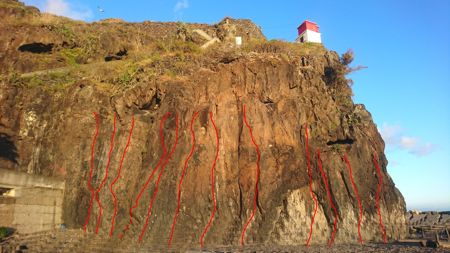
- 1.12.1. Flipflop / Tip of the Sun / Ponta do Sol 7 in Crag
- 1.12.2. Ribeira Brava / Lighthouse / Farol 18 in Crag
- 1.12.3. Lombo do Mouro / Pico das Pedras 21 in Crag
- 1.12.4. Glaciar 13 in Crag
- 1.12.5. Pináculo de Folhadal / Serra de Agua 2 in Crag
- 1.12.6. Pico da Encumeada 1 in Crag
- 1.12.7. Pico Grande 3 in Crag
- 1.12.8. Pico do Prego 1 in Crag
- 1.12.9. Pico das Torres 1 in Crag
- 1.12.10. Pico do Cidrão 2 in Crag
- 1.12.11. Juncal / Pico do Arieiro 9 in Crag
- 1.12.12. Boca do Buraco / Mouth of the Hole 9 in Crag
- 1.12.13. Poço da Neve 1 in Crag
- 1.12.14. Paredão 3 in Crag
- 1.12.15. Chão das Galinhas / Ground of the Chickens 1 in Crag
- 1.12.16. Socorridos / Levada Piornais 26 in Crag
- 1.12.17. Praia Formosa 16 in Area
- 1.12.18. Terreiro da Luta / High Rock / Fighting Ground / Rocha Alta 1 in Crag
- 1.12.19. Peugeot / Ribeira João Gomes 14 in Crag
- 1.12.20. Madeira Climbing Center 10 in Gym
- 1.12.21. São Gonçalo 29 in Crag
- 1.12.22. Lizard Crag 1 in Boulder
- 1.12.23. Porto Novo 5 in Crag
- 1.12.24. Falling Rock 11 in Crag
- 1.12.25. Parque Desportivo Água de Pena 16 in Artificial
- 1.12.26. Ponta de São Lourenço / Caniçal 35 in Crag
- 1.12.27. Praia do Faial / Faial Beach 12 in Crag
- 1.12.28. Cais Antigo Calhau Sao Jorge / Old Wharf Calhau Sao Jorge 3 in Crag
- 1.12.29. Seixal 4 in Area
- 1.12.30. Ribeira da Janela – Praia 2 in Crag
- 1.12.31. Piscinas Cachalote / Porto Moniz 4 in Crag
- 1.12.32. Piscinas Naturais do Porto Moniz 1 in Area
- 1.12.33. Paul do Mar 1 in Crag
- 1.12.34. O Farelhão / The Bran 2 in Crag
- 1.12.35. Pico de Ana 1 in Crag
- 1.12.36. DWS 6 in Crag
- 1.12.37. Balcões 1 in Crag
- 1.12.38. Achada do Teixeira 2 in Area
- 1.12.39. Cabana do Neptuno / Neptuns Cabin 1 in Crag
- 1.12.40. Rock Needle 1 in Crag
- 1.12.41. Ponta do Clerigo 1 in Crag
-
1.1.
Minho 514 in Region
1. Portugal 6,388 routes in Region
- Summary:
-
Sport climbing, Bouldering and other styles
Lat / Long: 37.235068, -19.365670
description
Location and topos of many areas in Portugal can be found here (click on map): http://climbingportugal.blogspot.com/
1.1. Minho 514 routes in Region
- Summary:
-
Sport climbing, Bouldering and other styles
Lat / Long: 41.626189, -8.543148
1.1.1. Vila Nova de Cerveira 24 routes in Crag
- Summary:
-
Sport climbing, Top roping and other styles
Lat / Long: 41.947329, -8.726732
1.1.2. Serra de Arga 145 routes in Crag
- Summary:
-
Sport climbing, Bouldering and Trad climbing
Lat / Long: 41.846714, -8.730009
description
1.1.3. Monte São Mamede 70 routes in Crag
- Summary:
-
Mostly Sport climbing
Lat / Long: 41.629230, -8.250339
description
Croquis Sector Cavalos: https://www.fpme.org/webpu/index.php/zonas-de-escalada/croquis/425-monte-de-s-mamede-sector-cavalos
1.1.4. Escola de Escalada do Castelo (Póvoa e Lanhoso) 34 routes in Crag
- Summary:
-
Sport climbing, Trad climbing and other styles
Lat / Long: 41.586008, -8.281108
description
A good introduction to granite slab climbing, with varying grades.
Easier first (sport) pitches lead to more demanding (sometimes trad) pitches as the wall steepens.
https://fpme.org/webpu/index.php/49-escalada-em-rocha/485-zona-de-monte-pilar-povoa-do-lanhoso
1.1.5. Penha 33 routes in Area
- Summary:
-
Mostly Sport climbing
Lat / Long: 41.431764, -8.269262
1.1.6. Belinho 19 routes in Area
- Summary:
-
All Sport climbing
Lat / Long: 41.590753, -8.778766
approach
Approach to the multiple sectors can be found here http://climbingportugal.blogspot.com/2013/05/belinho-esposende.html
1.1.7. Corno de Bico 63 routes in Field
- Summary:
-
All Bouldering
Lat / Long: 41.903128, -8.501518
1.1.8. Poço Negro (Areosa) 11 routes in Area
- Summary:
-
Mostly Bouldering
Lat / Long: 41.723590, -8.846626
- Trad route: Drive from Viana do Castelo to Caminha. In the parish of Areosa, take the road to S. Mamede. On S. Mamede road, after passing the water tanks on the right, park at the first fork in the road. Follow the dead-end road on foot and take the path to the right of the house. When you see the waterfall (Poço Negro), the wall will be on the right, and at it's top you will see a large cross.
approach
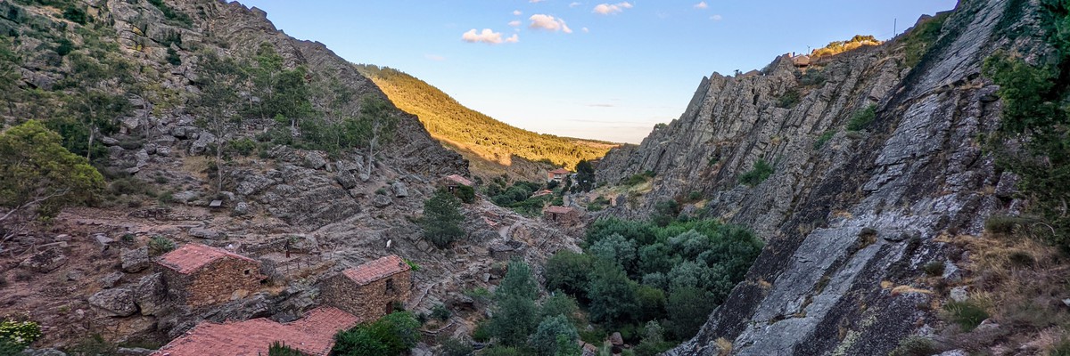
1.1.9. Gerês 112 routes in Crag
- Summary:
-
Trad climbing, Sport climbing and Aid climbing
Lat / Long: 41.855890, -8.156826
1.2. Trás-os-Montes 364 routes in Region
- Summary:
-
Sport climbing, Trad climbing and other styles
Lat / Long: 41.506486, -7.198703
1.2.1. Escarpas do Corgo 51 routes in Crag
- Summary:
-
Sport climbing and Trad climbing
Lat / Long: 41.294275, -7.742246
summary
Convenient urban climbing area. Easy access, diverse routes. Good amenities in Vila Real. Quality granite rock. Equipped and natural protection routes. Varied descent methods. M-10 bolts were used.
description
As a tradition, in areas equipped by the G.M.V.R. (Vila Real Mountaineering Group), routes that allow natural protection are left unequipped. Therefore, you will find fully equipped, mixed, and non-equipped routes. The top anchors are always equipped.
descend by rappelling down the route itself. Only in the "Yellow" sector, some top anchors are not equipped for descent. In such cases, simply traverse along the top of the wall to reach the nearest equipped top anchor.
All the topos and information could be found at this link.
access issues
This climbing area is located within the city of Vila Real. The CP train station can serve as a reference point.
You can use this link at Wikiloc to approach the Sector "Hamburger" and "Naranjinhos".
approach
The different climbing areas have an easy approach along a marked path, which may require more effort on the return journey. Accessing the yellow sector can be slightly more challenging, although a new path is currently being opened to connect this sector with the others.
where to stay
The city offers a camping site. Alternatively, you can use the mountain refuge owned by the Vila Real Mountaineering Group in a nearby village, or even bivouac at the climbing area.
ethic
The fixed gear used includes M-10 bolts and occasionally pitons, although they are currently being replaced.
history
Equipped by GMRV - Grupo de Montanhismo de Vila Real www.grupomontanhismovr.com
1.2.2. Serra dos Passos 93 routes in Crag
- Summary:
-
Sport climbing and Trad climbing
Lat / Long: 41.462485, -7.288608
summary
Equipped by GMRV - Grupo de Montanhismo de Vila Real www.grupomontanhismovr.com
description
Created in early 90's, with efforts from João Animado and Abel Fortuna. Recently had a second development by the hand of Filipe Cardinal. Quartzite stone from 20m to 40m of heigh, both sport and trad routes.
access issues
If coming from Vila Real or Mirandela via IP4, take the exit marked for L. de Orelhão and Abreiro at kilometer 145. At the first intersection, turn left towards Passos. After a few kilometers, you'll enter the village where you should take the first cobblestone road on the left. Follow this road through the village until you reach the intersection near the new primary school, where you'll turn left. After a few meters, the cobblestones end and the road becomes unpaved. Continue for approximately 5 kilometers, passing by the guard's house and some cliffs where the first climbing routes begin (not marked on the guidebooks). At a crossroad with a left turn, continue for a few more kilometers until you see the church cross and a sharp left curve at the only existing intersection.
approach
41º27'45"N 7º17'24"O
where to stay
You can stay in Mirandela the nearest town or you can bivaque on place.
1.2.3. São Bento 82 routes in Area
- Summary:
-
Sport climbing and Trad climbing
Lat / Long: 41.375515, -7.686407
summary
Equipped by GMRV - Grupo de Montanhismo de Vila Real www.grupomontanhismovr.com
approach
41º22'32,772"N 7º41'6,893"
1.2.4. Serra do Marão 2 routes in Area
- Summary:
-
All Sport climbing
Lat / Long: 41.239616, -7.869449
approach
Leave the car here: https://maps.app.goo.gl/6WiXqUBVzUGAN1H58 Short 20-30 min walk to the base of the crag.
1.2.5. Santa Bárbara 4 routes in Field
- Summary:
-
All Bouldering
Lat / Long: 41.669613, -7.520537
1.2.6. Vilarelho 29 routes in Area
- Summary:
-
Trad climbing, Sport climbing and other styles
Lat / Long: 41.511995, -7.542152
description
This crag/area information is provided with a lot of googling and searching across multiple Portuguese blogs that I've (Victor Fernandes) found across the internet.
Portuguese info at: - http://stpesapeida.blogspot.com/2011/05/novas-vias-em-vilarelho.html - http://vilarelhoparipassu.blogspot.com/2014/07/croquis-da-escola-de-escalada-de.html - http://climbingportugal.blogspot.com/2014/08/vilarelho-fraga-do-alto.html - https://www.google.com/maps/d/u/0/viewer?ie=UTF8&hl=pt-PT&msa=0&t=h&om=1&ll=41.03948432006434%2C-9.290480000000017&mid=13jGbq1kiPW3yELEXInVAwqf6zS4&z=5
1.2.7. Fradinho 36 routes in Area
- Summary:
-
All Sport climbing
Lat / Long: 41.108634, -7.550006
summary
The rock in Tabuaço is granite which allows different types of climbing. There you've fissures, slats, and handles. Some routes are really cool because allow you the creativity of your body to climb some unique routes. The rock is a non-aggressive fine-grained granite, with the exception of the 5 lanes equipped in the Malagueta sector, which incorporates a different type of climbing.
1.2.8. Veiga de Lila 30 routes in Crag
- Summary:
-
Mostly Sport climbing
Lat / Long: 41.520078, -7.314879
summary
Sunny, almost every time dry and with good conditions to climb. A remarkable region to travel, eat and staying.
description
The latest crag in the area, with a great capability of expansion. Plenty of well bolted medium level routes on very variable rock structures. Pretty, sunny, and in wild area. impossible during summer neither.
approach
Park in Capela de Santa Bárbara open parking (41.520872, -7.315667) From this point follow the “mariolas” small stone towers until Sector 1
history
Start bolted in 2023 by Oscar Fernandes Oscar Fernandes and Almir Alicate
1.2.9. Soutelinho do Monte 0 routes in Crag
1.2.10. Alvão 0 routes in Field
1.2.11. Salselas 13 routes in Field
- Summary:
-
All Bouldering
Lat / Long: 41.546108, -6.881215
- Respect the area and locals.
- Be cautious with the rock in the mined section.
- Watch out for submerged bases of boulders at certain times of the year.
summary
More information and topos (in Portuguese) at Boulder Trás-os-Montes one of the blogs of João Paulo Ferreira
description
An old abandoned lime mine left underground galleries exposed. The mined section has deteriorated rock, but the galleries are interesting for climbing. The region has about a dozen good-quality boulders, offering a fun afternoon on this peculiar rock amidst the surrounding granite and shale. While it may not be a prominent or extensive area, it is an interesting curiosity worth visiting.
ethic
1.2.12. Tourencinho 14 routes in Crag
- Summary:
-
All Rock climbing
Lat / Long: 41.425103, -7.665587
1.2.13. Cidadelha 10 routes in Crag
- Summary:
-
Trad climbing and Sport climbing
Lat / Long: 41.515421, -7.652394
description
TODO: Add routes from here https://climbingportugal.blogspot.com/2013/05/cidadelha-vila-pouca-de-aguiar.html
1.3. Porto 768 routes in Region
- Summary:
-
Bouldering, Sport climbing and other styles
Lat / Long: 41.055554, -8.293299
1.3.1. Santo Tirso 165 routes in Crag
- Summary:
-
Mostly Bouldering
Lat / Long: 41.315437, -8.443693
description
This place has more than 200 boulders hidden in the Nossa Senhora da Assunção woods. This is one of the most iconic boulder places in the North of Portugal. Also, you can use your sport climbing equipment on some boulders that are equipped with anchors but also you can find twelve sport climbing routes at sector da Patuda (The difficulty of those routes are between III and 7a+).
Topo could be found in "Portugal, Escalada em Rocha" by Carlos Simes. Or for a more detailed version you have: https://euroclimbing.com/files/2010/01/Blocos-Santo-Tirso-Nossa-Senhora-da-Assun%c3%a7%c3%a3o.pdf
1.3.2. Serra do Pilar 7 routes in Crag
- Summary:
-
All Sport climbing
Lat / Long: 41.139788, -8.605322
1.3.3. Senhora Salto 94 routes in Crag
- Summary:
-
Sport climbing and Trad climbing
Lat / Long: 41.128344, -8.434180
description
")
1.3.4. Serra de Valongo 74 routes in Area
- Summary:
-
Mostly Sport climbing
Lat / Long: 41.164684, -8.481726
description
1.3.5. Pedra da Tartaruga 14 routes in Field
- Summary:
-
All Bouldering
Lat / Long: 41.341174, -8.752275
1.3.6. São Paio 69 routes in Field
- Summary:
-
All Bouldering
Lat / Long: 41.280685, -8.730364
description
Really cool bouldering area with good access
approach
Arrive by car and park at Praia Castro de São Paio or at Praia de Labruge.
ethic
This is a protected area, with a lot of history. Don't litter, try to not wander off the path, do not over chalk the rock, and avoid destroying the vegetation.
history
Castro de S. Paio, in the parish of Labruge, is the only proto-historical maritime settlement known in Portugal. It was discovered in the 1950s by Fernando Lanhas and D. Domingos de Pinho Brandão. Surface structures, ceramic and various rock engravings were discovered.
Nowadays, it is possible to see the ruins of some housing constructions - with interpretive plates - and rock engravings in the cliffs, and to know a little better this castro, and the settlements of the Iron Age in general, visiting the interpretation centre, at Moreiró.
1.3.7. Praia do Facho 26 routes in Crag
- Summary:
-
All Bouldering
Lat / Long: 41.227220, -8.720514
summary
Excellent rock quality boulders besides the sea, with easy access, right next to Praia do Facho
description
An amazing place right at Praia do Facho, with potential for some good sessions of bouldering. The area is not huge, but the quality of the rock (granite) is impressive considering it is right next to the sea.
Most routes are on the short side, due to the boulders not being very high, but the diversity of rock features ensures that the climbing will be fun. You can find some overhanging (almost roof) routes as well as slabs.
Depending on the weather and sea levels, it might be impossible to do some boulders due to the water on the ground (the water gets trapped in puddles).
approach
There is a car parking at Praia do Facho https://goo.gl/maps/548G5kP5476ZC9do7 (probably full on the busiest days) near the restaurant and then cross the sand to reach the rock formation (visible from the park)
1.3.8. Lavadores 110 routes in Crag
- Summary:
-
Mostly Bouldering
Lat / Long: 41.132240, -8.669776
summary
Boulder area directly on the coast.
description
Google Maps link with boulders exact location: https://www.google.com/maps/d/edit?mid=1JjGl0vklwDcXFJo6UlI_DLpF1Wa0gw8
history
The first internet record of climbing here dates back to 2 Fev 2011 where Crack is climbed in this YouTube video https://www.youtube.com/watch?v=WFXnX3WPcXw The records of most boulders date to 2020 by Ewa Czar in 27crags https://27crags.com/crags/lavadores/authors
1.3.9. Jurassic Park 13 routes in Crag
- Summary:
-
All Sport climbing
Lat / Long: 41.055268, -8.336708
description
1.3.10. Gondifelos 9 routes in Crag
- Summary:
-
Mostly Sport climbing
Lat / Long: 41.414021, -8.610387
summary
For more information, please visit the following link (in Portuguese):
access issues
The climbing walls are on private property. Respect and adhere to all rules and regulations in place.
approach
Take the A28 (Porto/Viana do Castelo) and exit at Vila do Conde. Follow the signs towards Famalicão/Guimarães on EN206. At Km 13.5, approximately 700 meters after a left turn towards Grimancelos and Negreiros, turn right between the walls. After about 800 meters and just past Café Ribeiro (parking available here), turn left and walk about 100 meters until you find an open gate on the right side, providing access to a pine forest. Follow the path on the left, which will take you to the top of the routes in just 2 minutes.
For those coming from the A3 (Porto/Valença), exit at Famalicão and head towards Vila do Conde/Póvoa de Varzim. Continue for approximately 8 km until you reach Gondifelos. About 1 km after the SOPOR gas station, when encountering a slight incline, turn left between the walls and follow the previous directions.
1.3.11. The North Wall 0 routes in Gym
1.3.12. Murus 0 routes in Gym
1.3.13. São Rock 0 routes in Gym
1.3.14. PROA 0 routes in Gym
1.3.15. Zone 0 routes in Gym
1.3.16. Castelo de Paiva 70 routes in Area
- Summary:
-
Sport climbing, Bouldering and Trad climbing
Lat / Long: 41.033499, -8.309472
description
 Castelo de Paiva is a town in northern Portugal, located in the district of Aveiro. It is surrounded by the municipalities of Cinfães to the east, Porto and Arouca to the south, and Gondomar to the west. It is a land blessed with numerous rivers and streams, including the Douro River along its entire length, as well as the Paiva, Arda, Sardoura, and others. The region is rich in various types of rock, with granite, schist, and quartzite being predominant, making it a great destination for climbing in all its forms.
Portuguese: Castelo de Paiva é uma vila do norte de Portugal pertencente ao distrito de Aveiro, é ladeada pelos concelhos de Cinfães a leste, Porto e Arouca a sul e a oeste por Gondomar. Uma terra banhada por imensos rios e ribeiros, nomeadamente o Rio Douro em toda a sua extensão, rio Paiva, Arda, Sardoura, etc. Rica em vários tipos de rocha, onde a predominância é o granito, xisto e quartezito, potencia a prática da escalada em todas as suas vertentes.
1.3.17. Serra da Freita 117 routes in Crag
- Summary:
-
Bouldering, Sport climbing and other styles
Lat / Long: 40.872050, -8.272156
1.3.18. One Soul Climbing 0 routes in Gym
1.4. Coimbra-Viseu 593 routes in Region
- Summary:
-
Mostly Sport climbing
Lat / Long: 40.329853, -8.433079
1.4.1. Redinha 72 routes in Crag
- Summary:
-
All Sport climbing
Lat / Long: 39.993913, -8.550783
description
Limestone crag situated halfway between Porto and Lisbon enjoys a privileged location as a viewpoint overlooking the sea. The routes vary between 7 and 20 meters and are spread over a fringe of rock with a length of about 400 meters. The routes vary between the 3rd and the 8th grade, being notoriously an area of initiation to climbing given the number of accessible routes.
Find the topo here: https://montanhaescalada.com/redinha/
There is no water supply nearby. For food, in the village of Redinha we find a supermarket, bakery, cafe and restaurant where you can eat. It is possible to do “wild” camping in several places along the walls being perhaps the best next to the chapel of Senhora da Estrela taking advantage of the large rock vault to protect from the rain. There is also a rural tourism accommodation in the village of Poios.
approach
1 to 10 minutes depending which sector you want to climb
1.4.2. Vale de Poios 202 routes in Crag
- Summary:
-
Mostly Sport climbing
Lat / Long: 39.980771, -8.552114
description
One of the most famous crags in Portugal, it contains a significative set of limestone sectors with max height of 25 m. Poios contains various excellent sectors with a number of contrasting routes from technical vertical walls to overhanging steep juggy routes and include roof ceilings as well.
approach
Depends on the sector, you may have to walk from 5 minutes to 20 minutes to reach Sol Poente.
where to stay
Poios it is a small village where there are few options of local accomodation with very welcoming people. Also it is common for people to bivacquing or stay with vans nearby the parking or nearby Redinha climbing sector.
1.4.3. Poio Velho 48 routes in Area
- Summary:
-
All Sport climbing
Lat / Long: 39.969319, -8.552417
summary
Not very popular limestone crag close to Poios. Very hot in summer. Parking 39.97163945408407, -8.546150189975563
1.4.4. Fragas do Cercal 23 routes in Crag
- Summary:
-
All Sport climbing
Lat / Long: 39.953013, -8.314067
1.4.5. Buracas do Casmilo 125 routes in Crag
- Summary:
-
All Sport climbing
Lat / Long: 40.046444, -8.497515
1.4.6. Fragas de São Simão 5 routes in Crag
- Summary:
-
Sport climbing and Trad climbing
Lat / Long: 39.916211, -8.316410
description
Three multipitch routes just next to the Fragas de São Simão river beach. The beach is very popular and you'll be very likely not alone. There is a small bar close to the start of the routes, too.
Topo: http://climbingportugal.blogspot.com/2013/05/fragas-de-s-simao-figueiro-dos-vinhos.html
approach
Parking at (39.915500, -8.319656). From there, follow the path rightwards towards Fragas de São Simão. The routes can be found on the right side of the river just next to the upper basin.
where to stay
Tolerated camping area (only tents) close to the parking, a bit downstream on the other side.
1.4.7. Penacova 25 routes in Area
- Summary:
-
Trad climbing and Sport climbing
Lat / Long: 40.273729, -8.279944
1.4.8. Santarinho 16 routes in Sector
- Summary:
-
Mostly Sport climbing
Lat / Long: 40.655849, -7.942248
1.4.9. Caramulinho 32 routes in Area
- Summary:
-
Mostly Sport climbing
Lat / Long: 40.547321, -8.202274
description
Fine-grained blue granite with a height range of 10 to 18 meters. Dihedrals, chimneys, and scarce holds, as well as slab and adherence.
Other information: - Drinking water near the parking lot - Facing west and sun exposure from 11 a.m. on - Altitude beyond 1000m - Base not suited for children under the age of 6
approach
5 minutes walking from the nearby street.
1.4.10. Garganta do Cabril do Ceira 1 route in Area
- Summary:
-
All Deep water soloing
Lat / Long: 40.177112, -8.172743
summary
Beautiful geological formation of quartzite slashed through in the middle by the river Ceira, creating a steep tunnel and areas with deep water and a nice beach. There's an annual slackline event here
1.4.11. Vila Nova De Poiares 44 routes in Area
- Summary:
-
Mostly Sport climbing
Lat / Long: 40.217395, -8.218066
summary
Well bolted crag, easy access, every grade from 4 to 7b with a free Topo provided by the local council and FPME. Nicely featured, pocketed and high quality rock (hard quartzite).
description
Topo provided by the local council and FPME: https://fpme.org/webpu/index.php/49-escalada-em-rocha/433-zona-de-escalada-da-fraga-da-pena-vila-nova-de-poiares
access issues
N/A
approach
Go up N17 from Vila Nova de Poiares, turn right towards Alveite Grande, following signs for climbing area! Park within sight of crag at noticeboard. Walk immediately down a rocky path from the noticeboard (with Topo). The path will veer to the left. Proceed over a small wooden bridge as the path goes right along a small brook through the woods. Look out for small but distinct paths off to the left. The first path to the left is for Rua Sesamo (the easier crag) and the path that goes straigh ahead then slightly left leads up to the harder crag Penando da Desgraça.
where to stay
history
1.5. Beira Interior 547 routes in Region
- Summary:
-
Sport climbing, Bouldering and other styles
Lat / Long: 40.304719, -7.415990
summary
Zone géographique regroupant plusieurs sites d'escalade.
description
Une association de Castelo Branco (Clube Raia Aventura) avec l'appui des villes concernées et d'autres entités ont créé un petit guide gratuit en 2019 qui regroupe les sites d'escalade locaux: Roteiro de Escalada da Beira Interior. Disponible dans les offices de tourisme de Fundão, Oleiros, Idanha-A-Nova, Proença-A-Nova, etc.
1.5.1. Penedo Barroco 52 routes in Crag
- Summary:
-
All Sport climbing
Lat / Long: 40.083961, -7.753446
summary
Great area with one main overhanging cliff and several other easier cliffs. All routes are very well bolted. More info here: http://montesdevolucao.blogspot.com/2006/07/novos-croquis-da-escola-de-escalada-do.html
description
Lots of shade, access has been improved; bring a clipper if possible to help trim the bushes ;-) A 50m rope will be more than enough.
approach
Drive on N238 to (40.075574, -7.748731). Then head NW on the dirt road, follow the sign "parque de merendas". Drive mostly down hill for about 1km to the first hairpin turn and park there (40.075574, -7.748731). Hike the trail that starts there.
1.5.2. Barragem Santa Luzia 26 routes in Area
- Summary:
-
Mostly Sport climbing
Lat / Long: 40.089703, -7.862911
summary
A major rock climbing area in Central Portugal with sport, traditional, single and multi-pitch routes.
description
More detailed info here (use these free available topos at your own risk as you will find different grades depending on the topo...): https://safe-climbing.org/croquis/ https://docs.google.com/document/d/1fzFO78d9idSUzoMpu1beDbueCyl4s6VMsM_YT_kr4nY/pub and here: http://climbingportugal.blogspot.com/2013/05/barragem-de-santa-luzia-pampilhosa-da.html
1.5.3. Castelo Novo 18 routes in Crag
- Summary:
-
All Sport climbing
Lat / Long: 40.066704, -7.503273
summary
Plusieurs blocs en granit équipés. Deux groupes de blocs développés à ce jour (octobre 2023)
description
Une ambiance lunaire avec l'altitude, les blocs de granits, la vegetation spartiate et l'accès par une piste étroite et qui grimpe aussi pas mal !
approach
Suivez la piste jusqu'ici: https://goo.gl/maps/sySQMzs6WUCzALda8 puis courte marche vers les blocs en contre bas pour les secteurs Punhal et OVNI.
1.5.4. Serra da Estrela 317 routes in Crag
- Summary:
-
Bouldering, Sport climbing and Trad climbing
Lat / Long: 40.389423, -7.564871
description
1.5.5. Penha Garcia 50 routes in Crag
- Summary:
-
Mostly Sport climbing
Lat / Long: 40.043903, -7.014918
summary
The quartzitic rock, although highly solid and hard, is heavily fractured. The equipped routes, although thoroughly cleaned, require moderate attention to prevent potential falls of blocks or slabs. You could find the "official" topo here.
description
Penha Garcia is a rock climbing school in quartzite, where fissures and slats abound, requiring climbing on technical slabs, cracks, and athletic extra plummets. It is possible to climb multi-pitch here too. The height of the roads varies between 8 and 45 meters and the grades between III and 7c. “Placa das Tartarugas” is a slab sector with most routes.
Ĩt is a rural place with great views and nature, where it is possible to camp and meet the traditional Portuguese lifestyle, food, and culture.
approach
A good place to park is close to the dam (google map coordinates 40.04559229833553, -7.014005700001631).
1.5.6. Oleiros 47 routes in Area
- Summary:
-
All Sport climbing
Lat / Long: 39.961447, -7.772996
summary
1.5.7. Portas do Almourão 37 routes in Area
- Summary:
-
All Sport climbing
Lat / Long: 39.737301, -7.751379
description
There is a croqui in front of the crag. Some routes were revised, but you can find an earlier version here: http://climbingportugal.blogspot.com/2013/05/portas-do-almourao-proenca-nova.html.
approach
The start of the road is in bad condition, depending on the car you can get close to the crag, otherwise it is a 25min walk from a safe parking spot before the dirt road.
1.5.8. Sortelha 0 routes in Field
1.6. Ribatejo 528 routes in Region
- Summary:
-
Sport climbing, Bouldering and other styles
Lat / Long: 39.406999, -8.487626
1.6.1. Envendos 120 routes in Area
- Summary:
-
Mostly Sport climbing
Lat / Long: 39.580301, -8.017952
1.6.2. Reguengo do Fetal 144 routes in Crag
- Summary:
-
Mostly Sport climbing
Lat / Long: 39.634219, -8.758568
description
One of the more important crags in central Portugal, featuring a good selection of interesting routes in all grades. The sectors have different orientations to the sun, meaning that one can climb all day long and during summer and winter as well.
approach
Several parking possibilities on the street below the crag. From there, all sectors can be reached within few minutes. Changing sectors, for example from the sunny to the shady side of the crag, is also easy and quickly done.
where to stay
Bivouacking is tolerated, B&B in Reguengo. The next official camping is in Pedreiras (18km).
1.6.3. Vale dos Ventos (Reguengo do Fetal) 20 routes in Area
- Summary:
-
All Sport climbing
Lat / Long: 39.624743, -8.757423
1.6.4. Alcaria 13 routes in Crag
- Summary:
-
All Sport climbing
Lat / Long: 39.575100, -8.792993
1.6.5. Poio D'Aire 14 routes in Crag
- Summary:
-
All Sport climbing
Lat / Long: 39.533685, -8.699809
1.6.6. Lapas 63 routes in Crag
- Summary:
-
Mostly Sport climbing
Lat / Long: 39.659283, -8.415437
description
Croquis: https://drive.google.com/file/d/10wT3ghY9IgBtJJtN6V8LfJg04VrIElF3/view?usp=drivesdk
Description: https://montanhaescalada.com/sra-lapas-tomar/
1.6.7. Vale da Serra (Pedrógão - Torres Novas) 60 routes in Crag
- Summary:
-
All Bouldering
Lat / Long: 39.523968, -8.603242
1.6.8. Pafarrão 36 routes in Crag
- Summary:
-
All Sport climbing
Lat / Long: 39.555265, -8.579967
description
http://climbingportugal.blogspot.com/2013/05/pafarrao-torres-novas.html
http://escaladapafarrao.blogspot.com/2012/12/croquis-das-zonas-de-escalada-do.html
1.6.9. Aldeia da Pena (Torres Novas) 28 routes in Crag
- Summary:
-
All Sport climbing
Lat / Long: 39.582499, -8.544483
description
https://www.facebook.com/escalatudo
http://estoupraver.blogspot.com/2013/04/croquis-de-escalada-da-aldeia-da-pena.html
1.6.10. Bloco do Bairro 28 routes in Field
- Summary:
-
All Bouldering
Lat / Long: 39.565305, -8.581709
description
1.6.11. Ventas do Diabo 2 routes in Crag
- Summary:
-
All Trad climbing
Lat / Long: 39.536540, -8.732771
description
1.7. Estremadura 194 routes in Region
- Summary:
-
Mostly Sport climbing
Lat / Long: 39.462339, -9.167329
1.7.1. Nazaré 8 routes in Area
- Summary:
-
All Bouldering
Lat / Long: 39.606489, -9.083467
1.7.2. Ericeira 3 routes in Crag
- Summary:
-
All Bouldering
Lat / Long: 38.999250, -9.419755
1.7.3. Montejunto 96 routes in Crag
- Summary:
-
All Sport climbing
Lat / Long: 39.179165, -9.055385
description
https://montejunto.pt/locais-de-escalada/
Topo/croquis: http://climbingportugal.blogspot.com/search?q=MONTEJUNTO
access issues
Climbing in sector Montejunto Velho is closed every year from 1st February - July 31st. Climbing in sector Montejunto Novo is allowed all year around.
1.7.4. Camarnais - Pó (Olho Marinho) 11 routes in Crag
- Summary:
-
Mostly Sport climbing
Lat / Long: 39.309473, -9.226162
description
https://www.facebook.com/photo?fbid=4932298743446785&set=gm.439595347622602
Update: https://www.facebook.com/photo/?fbid=5709428065733845&set=pcb.600165981565537
And a lonely trad route: https://www.facebook.com/photo/?fbid=4928592377150755&set=pcb.438887984360005
1.7.5. Peniche 55 routes in Area
- Summary:
-
Mostly Sport climbing
Lat / Long: 39.363259, -9.386190
summary
Switch up the surfing in the area with some bouldering, trad climbing and sport climbing with the ocean smashing into the cliffs beneath you.
description
Peniche is a peninsula sticking out into the Atlantic ocean and is best known for its all year round surfing. But along side the fisherman town's coastline there's plenty of climbable limestone that is yet to be developed.
access issues
Most climbing areas are situated next to the ocean. Be aware and inform yourself on the tidal and climatic conditions.
1.7.6. Canto das Lages 21 routes in Crag
- Summary:
-
Sport climbing and Trad climbing
Lat / Long: 39.470325, -9.201659
summary
Mostly trad routes. Top roping setups possible but bring a safety rope and anchor gear. Great spot with ocean view and North facing (shade!). Great potential but still quite undeveloped.
description
Croquis: https://www.facebook.com/groups/escalada.peniche
http://climbingportugal.blogspot.com/2013/06/canto-das-lages-serra-do-bouro-caldas.html
approach
Look for trail head and cliff on Gmaps. Easy walk. Don't bushwalk on the faint trail (many spiky bushes!) when you see the cliff, keep going closer to the higher base and you'll find the trail that goes down to the base of the cliff.
1.8. Região de Lisboa 1,497 routes in Region
- Summary:
-
Sport climbing, Bouldering and other styles
Lat / Long: 38.645397, -9.082593
1.8.1. Casal de Pianos 83 routes in Crag
- Summary:
-
All Trad climbing
Lat / Long: 38.892196, -9.438455
access issues
Private property :-/ The angry owner don't want that people climb here.
1.8.2. Penedo da Amizade 79 routes in Crag
- Summary:
-
Mostly Sport climbing
Lat / Long: 38.792384, -9.390646
description
Granite climbing, decent bolt installation and placements. Access to the top climbs not as easily noticeable but there's a few paths that head in those directions. Check the installed topo at the crag, and also the hiking signs to find other areas. This is a micro climate on this hill. It might be warm and sunny down the bottom, but consider taking warmer clothing for the crag.
access issues
No crazy access issues to the first few climbs, however vegetation and moss has grown over some areas so you'll need to keep a close eye out for features on the rock to know where you are along the wall. No noticeable signage to the upper areas (closer to the base of the castle wall), check the topo and the hiking signs together to find your way.
approach
Easy approach. Park at ( 38.790194, -9.392528)
and follow the signs down to the crag. Keep an eye out for the installed sign with the route names and grades. (same as the attached photos of this area)
38.790194, -9.392528)
and follow the signs down to the crag. Keep an eye out for the installed sign with the route names and grades. (same as the attached photos of this area)
1.8.3. Pedra Amarela 18 routes in Crag
- Summary:
-
All Sport climbing
Lat / Long: 38.774785, -9.430569
- head EAST talking the dirt road that is parallel to the tarmac road.
- walk for about 500m and take a right (it means ignore the first right that comes at about 200m)
- then take the first right
- within a few more meters you'll be at the top of the crag
- get to the bottom of the crag through the left
description
Source: Lisbon Climbing Guidebook 2020.
approach
Park at the Convento dos Capuchos Parking. Back up the road from Convento dos Capuchos parking, in the road crossings, there is also some dirt-area where parking is possible, but note that it is not a designated parking area.
To get to the crag, starting from the road crossings up from Convento dos Capuchos:
1.8.4. Cabo da Roca 112 routes in Area
- Summary:
-
Trad climbing, Sport climbing and other styles
Lat / Long: 38.777747, -9.493177
1.8.5. Encosta dos Bêbados 14 routes in Crag
- Summary:
-
All Sport climbing
Lat / Long: 38.731014, -9.431659
description
1.8.6. Farol da Guia 114 routes in Crag
- Summary:
-
Mostly Sport climbing
Lat / Long: 38.694833, -9.446831
summary
Sun, sea and climbing everything together for good times.
description
Well established and sometimes a bit crowded sea cliff with very short approach in the middle of Cascais. Plenty of well bolted medium level routes on very variable rock structures. Pretty sunny and often a bit sheltered from the sea breeze, so especially good on colder days, but not impossible during summer neither.
Route names and grades are written at the base of each climb, so a visit without a guide is unproblematic.
approach
--[en]--
Park along the street close to the Guia lighttower in Cascais (38.695944, -9.446788). From there, descent the stairs to reach sector Escadas / Bloco Escadas in less then 1min.
--[pt]--
A partir de Lisboa pode-se chegar a Cascais pela Marginal ou pela autoestrada. Em qualquer dos casos seguem-se as indicações para o Guincho. Chega-se à zona da Guia onde se pode avistar o respectivo farol. Pode estacionar-se o carro junto às bombas da Repsol. A entrada para o sector mais frequentado está bem indicada pelo recente pórtico.
Para quem venha do lado de Sintra, segue-se até à Malveira da Serra e daí até ao Guincho. A continuação desta estrada leva até à Guia. Embora seja um longo percurso, a beleza desta paisagem compensa bem o esforço.
1.8.7. Sintra 415 routes in Crag
- Summary:
-
All Bouldering
Lat / Long: 38.772404, -9.422067
description
This node includes only the bouldering sites in the Sintra mountain range. Other climbing and bouldering sites of the area are handeled seperately.
There is a local bouldering guide available for 33€ (Sintra Bouldering Guide book), send an email to bouldersintra@gmail.com for more information
Crashpad rentals at: https://bouldersintra.wordpress.com/crashpad-rentals/
where to stay
Various possibilities for renting holiday apartments all around. The only camping site is located in Guincho.
1.8.8. Baia do Mexilhoeiro 62 routes in Crag
- Summary:
-
Mostly Bouldering
Lat / Long: 38.693155, -9.434889
summary
Beautiful limestone crag by the sea with lots of boulders and a few sport routes. Perfect for interleaving bouldering with a dive in summer days.
description
Beautiful crag with lots of boulders and natural shallow pools right next to the sea. The rock feels okay but with some sharp edges and sometimes slightly slippery because of salt. The floor can be rough to walk bare-foot. Perfect spot to go for a dive during hotter days. There's usually a few fisherman and beachgoers there but is generally very calm.
access issues
Beware of rough sea and tall waves during high tides in the winter.
approach
You can park next to the Hot dog stand and 20m to the left when facing the sea, on the other side of the railing you can see stone steps and a metal door frame. Go down those steps and you're there.
ethic
On the way down to the crag there's a vandalised sign saying entry is not allowed, but there's generally people there, including beachgoers and fisherman.
1.8.9. Praia do abano 3 routes in Crag
- Summary:
-
All Bouldering
Lat / Long: 38.739519, -9.472943
1.8.10. Praia do Cavalo 5 routes in Crag
- Summary:
-
All Bouldering
Lat / Long: 38.801553, -9.486568
1.8.11. Praia da Adraga 3 routes in Field
- Summary:
-
All Bouldering
Lat / Long: 38.805718, -9.483644
1.8.12. Praia das Maçãs 2 routes in Crag
- Summary:
-
All Bouldering
Lat / Long: 38.824910, -9.469424
1.8.13. Vertigo 1 route in Gym
- Summary:
-
All Bouldering
Lat / Long: 38.739992, -9.102120
description
1.8.14. Bucelas 24 routes in Crag
- Summary:
-
All Sport climbing
Lat / Long: 38.879097, -9.128866
history
Original Introduction (The croquis on this link are not up to date):
1.8.15. Atlântida 46 routes in Crag
- Summary:
-
All Sport climbing
Lat / Long: 38.413096, -9.218060
description
Beautiful landscape where the land ends and the see begins. Magnificent routes although sometimes surrounded by adversities: tides, waves, humidity. The good advices of local climbers (or seegulls) are mandatory for a successful climbing day.
access issues
Avoid this cliff if the see is not calm, since even small waves can override the access and some base platforms. Local knowledge is mandatory. Consult the Lisbon climbing guidebook for good info.
1.8.16. Meio Mango 97 routes in Crag
- Summary:
-
All Sport climbing
Lat / Long: 38.412221, -9.210856
description
1.8.17. Azoia 68 routes in Area
- Summary:
-
All Sport climbing
Lat / Long: 38.425149, -9.177047
description
Azoia is a small climbing spot seperated in two sectors. 100m above the sea.
access issues
Former privat area but now abandoned.
approach
10 minutes.
1.8.18. Forte Do Cavalo 55 routes in Crag
- Summary:
-
Mostly Sport climbing
Lat / Long: 38.433692, -9.119476
1.8.19. Dente do Leão 13 routes in Area
- Summary:
-
All Sport climbing
Lat / Long: 38.438970, -9.087687
history
1.8.20. Varandas 3 routes in Crag
- Summary:
-
All Sport climbing
Lat / Long: 38.438175, -9.084419
1.8.21. Pedreiras 31 routes in Crag
- Summary:
-
All Sport climbing
Lat / Long: 38.436828, -9.064389
summary
Compact grey limestone, with pockets, crimps and a few tufas
description
Compact grey limestone, with pockets, crimps and a few tufas
approach
1.8.22. Fojo dos Morcegos 53 routes in Crag
- Summary:
-
Mostly Sport climbing
Lat / Long: 38.454110, -9.017103
description
approach
Parking in route N 397-1
(38.27337, 9.01128)
Trajeto até ao local https://pt.wikiloc.com/trilhas-escalada-na-rocha/fojo-dos-morcegos-43571801
2 km & 150 m
1.8.23. Fenda 136 routes in Crag
- Summary:
-
All Sport climbing
Lat / Long: 38.479787, -8.982818
description
Nice sustained climbing on compact limestone. 15 - 25m . Harder overhanging routes. Facing south, in the sun from noon. Shade for belayer.
access issues
38.4794950, -8.9836190 park here. Easiest approach is walk down 5 minutes with the path and repel down (15 meters) to crag Cu de Judas. This is also the way back up (3) Other option is park on the spot before (coming from west). Then you go down with the trail and need to take a left and walk below 20 minutes to the crag.
1.8.24. Praia da Figueirinha 19 routes in Crag
- Summary:
-
Sport climbing and Trad climbing
Lat / Long: 38.485362, -8.951876
description
Sunny crag above a tunnel. Nice view
access issues
Interdit to climb from February to June (including those months) due to bird nesting.
approach
Park at Praia da Figueirinha. Walk 150m west to the 2nd tunnel. At the entrance right climb the wall and a fixed rope to the top terrace where the climbing walls are.
1.8.25. Outão 22 routes in Crag
- Summary:
-
All Sport climbing
Lat / Long: 38.490182, -8.936111
description
approach
history
Topo.
1.8.26. Pinheirinhos 19 routes in Crag
- Summary:
-
Mostly Trad climbing
Lat / Long: 38.429633, -9.135430
description
approach
1.9. Alentejo 45 routes in Region
- Summary:
-
All Sport climbing
Lat / Long: 38.393670, -7.949674
1.9.1. Escusa 45 routes in Area
- Summary:
-
Lat / Long: 39.389795, -7.404272
description
Limestone striking wall of ribboned flowstone with impressive brown tufas. Between 25 and 50 routes, from 4c to 8a and some projects, with max height of 25 m and average height of 15 m. Majority of overhanging and some vertical routes.
You can find the topos here http://climbingportugal.blogspot.com/2013/09/caleiras-de-cima-escusa.html
approach
1 min walking. Actually, there are few parking spots nearby the crag.
history
It is an abandoned quarry in the middle of some roman ruins.
1.10. Algarve 399 routes in Area
- Summary:
-
Sport climbing, Bouldering and other styles
Lat / Long: 37.091630, -8.369125
1.10.1. Faro 0 routes in Area
1.10.2. Rocha da Pena 146 routes in Crag
- Summary:
-
Mostly Sport climbing
Lat / Long: 37.253854, -8.104192
description
A Rocha da Pena é a maior área de escalada do sul de Portugal. A menos de uma hora de carro de Faro, a falésia inclui vários sectores espalhados por uma extensão de 2 km, a poucos passos do parque de estacionamento próximo do Bar de Grutas. A rocha calcária é sólida na maioria das rotas, com uma variedade de apoios e estilos de escalada. Percursos do francês 4 ao 8 com muitos no 5º e 6º ano. As paredes estão viradas a sul, pelo que, com poucas excepções, os percursos são muito quentes e melhor escalados entre Setembro e Maio. Porém, de janeiro a junho, fique atento aos ninhos de aves e fique atento a possíveis avisos de áreas fechadas devido à proteção da fauna.
Rocha da Pena is the largest climbing area in south Portugal. Less than one hour by car from Faro, the crag includes many sectors spread over a length of 2 km, a short walk distance from the car park near the Bar de Grutas. The limestone rock is solid on most routes, with a variety of holds and climbing styles. Routes from French 4 to 8 with many in the 5th and 6th grade. The walls face south, so with few exceptions the routes are very hot and best climbed between September and May. From January to June though, be aware of nesting birds and watch out for possible warnings of closed areas due to fauna protection.
access issues
Suba com cautela durante a época de nidificação (janeiro - julho) esteja atento a quaisquer sinais no final das rotas que possam estar marcando-os.
Climb with caution during nesting season (January - July) be aware of any signs at the bottom of routes that may be marking them.
approach
Photo approach start.
ethic
Be mindful of possible warnings related to bird nesting - some sectors might be then temporarily closed. Also be respectful of the locals, do not camp/ sleep in car at the car park near the bar.
1.10.3. Albufeira 29 routes in Area
- Summary:
-
Mostly Sport climbing
Lat / Long: 37.092431, -8.254238
1.10.4. Portimão 6 routes in Area
- Summary:
-
All Bouldering
Lat / Long: 37.128602, -8.506418
1.10.5. Lagos 10 routes in Area
- Summary:
-
Mostly Bouldering
Lat / Long: 37.118036, -8.701086
1.10.6. Sagres 202 routes in Area
- Summary:
-
Sport climbing, Bouldering and other styles
Lat / Long: 37.054754, -8.939339
description
Múltiplas áreas de escalada em falésias separadas que rodeiam o Cabo de São Vicente, o ponto mais a sudoeste da Europa continental. A área inclui falésias deslumbrantes como The Mirror (rotas desportivas de 6a a 7a+, e boas linhas de comércio) e a Armação Nova de fácil acesso (desporto bem aparafusado de 6a a 7c numa saliência constante de 25 graus) e Foz de Fornos. Se quiser dar um mimo ao seu núcleo, Corgas é a escolha certa, uma parede íngreme pendente com a primeira 9a de Portugal.
Por ser uma zona marítima, existe sempre o risco de corrosão. No entanto, a maioria das rotas são em aço de qualidade (A4). Por favor, não equipe mais rotas - em vez disso, contribua para o reforço das rotas existentes com parafusos de titânio.
Multiple climbing areas on separate cliffs surrounding the Cabo de São Vicente, the most southwestern point in mainland Europe. The area includes stunning cliffs like The Mirror (sport routes from 6a to 7a+ and good trad lines) and the conveniently-accessed Armação Nova (well-bolted sport from 6a to 7c on a constant 25-degree overhang) and Foz de Fornos. If you want to give your core a treat, Corgas is the right choice, a steep overhanging wall with Portugal's first 9a.
Being a maritime area, there is always the risk of corrosion. Nevertheless, most routes are in quality steel (A4). Please do not equip more routes - instead contribute to the rebolting of existing routes with titanium bolts.
access issues
All areas are contained in the natural park (PNSACV) where climbing is forbidden.
Officialy since 2011 it's not legaly allowed to climb at Sagres Clifs. But since the park rangers are only 2 to square up all the National Park area, probably there would be no problems. Some of the bolts are getting rusty and might pop out, so always be carefull when coming down the routes (specially in Armação Nova, Foz dos Fornos and Corgas). Not adviced to climb in Parede Grande of Armação Nova (but belay points have new bolts). Recently almost all the routes in Parede Pequena at Armação Nova, Foz dos Fornos and in Corgas sector were rebolted with titanium glue in's (check out and support the portuguese project "Titan" at http://climbingpt.com/titan-project/the-problem/).
approach
Most climbs require abseil access. Belayer may get wet, check tide information.
Sagres is 50 mins on local bus from Lagos, bus timetable is not that frequent, make sure you know where last bus runs for that day.
where to stay
Either the town of Sagres or Lagos (very busy in summer).
1.10.7. Escada Maluca 1 route in Field
- Summary:
-
All Bouldering
Lat / Long: 37.146940, -8.915397
description
Listed here.
approach
1.10.8. Monchique 4 routes in Field
- Summary:
-
All Bouldering
Lat / Long: 37.315205, -8.566897
description
Listed here.
approach
1.10.9. Praia de Aljezur 1 route in Field
- Summary:
-
All Bouldering
Lat / Long: 37.348759, -8.846491
description
Lots of bouldering opportunities.
access issues
This is inside the natural park (PNSACV) where climbing is forbidden.
1.11. Azores 638 routes in Region
- Summary:
-
Sport climbing, Bouldering and other styles
Lat / Long: 38.589948, -27.759885
description
The Azores are an island group that is located about 800 miles east of Portugal in the Atlantic Ocean. There is sport climbing, bouldering and deepwatersoloing on inland but mostly sea cliffs, because it can rain and grow a lot. Precipitation and humidity gets more the further west the island is, so Sao Miguel is comparatively dry, Terceira and Pico in the middle and Flores is super green.
Weather wise, the best months to visit for climbing are arguably June, July and August when temperatures are over 20°C and precipitation is at its lowest, but you can climb year round. Often clouds and rain are hanging deep above 200hm, but the coast cliffs are still dry. Also note the strong microclimates, wind and wave direction is important, on one side of an island it can rain and wave a lot while on the other side it is dry and calm. For rain days you can also explore various kilometer long lava tunnels.
Most cliffs were developed after 2008 and you see a learning process: The older drilling bolts start rusting, especially those close to the ocean, and on some crags they started rebolting with glue in bolts. So take care with bolt quality and decide yourself whether you trust them, take in mind there is no mountain rescue.
Good article about Azores climbing. 2 local guidebooks mentioned here.
approach
There are normally direct flights from the US and Europe the Azores. Most flights will likely be in/out of Ponta Delgada (the largest city in the Azores, located on Sao Miguel Island), but som ir also going to Terceira. Once in the Azores, SATA, the local arm of Azores Airlines, offers short flights between each of the eight other Azorean islands. To fly is generally faster and similiar priced as ferries which even don't operate the whole year.
1.11.1. São Miguel 189 routes in Area
- Summary:
-
Bouldering, Sport climbing and other styles
Lat / Long: 37.808343, -25.496674
1.11.2. Santa Maria 10 routes in Area
- Summary:
-
Sport climbing, Rock climbing and Trad climbing
Lat / Long: 36.973168, -25.104256
1.11.3. Formigas 0 routes in Area
1.11.4. Faial 22 routes in Area
- Summary:
-
Bouldering, Sport climbing and other styles
Lat / Long: 38.581190, -28.709488
1.11.5. Pico 131 routes in Area
- Summary:
-
Sport climbing, Bouldering and other styles
Lat / Long: 38.455120, -28.284362
description
Most outdoor people come to Pico for the hike to Mount Pico, but there are also 5 nice sport crags and some bouldering and deepwatersoloing possibilities. Pico has strong microclimates, so when there clouds, wind, rain or waves mayb try the other side of the island, it might be calm and sunny there. Route List.
1.11.6. São Jorge 28 routes in Area
- Summary:
-
Mostly Sport climbing
Lat / Long: 38.644049, -28.050301
1.11.7. Graciosa 1 route in Area
- Summary:
-
All Deep water soloing
Lat / Long: 39.053450, -28.002243
1.11.8. Terceira 250 routes in Area
- Summary:
-
Sport climbing, Bouldering and other styles
Lat / Long: 38.716292, -27.209397
description
1.11.9. Corvo 1 route in Area
- Summary:
-
All Bouldering
Lat / Long: 39.700244, -31.110173
1.11.10. Flores 6 routes in Area
- Summary:
-
Mostly Trad climbing
Lat / Long: 39.448651, -31.192398
1.12. Madeira 298 routes in Region
- Summary:
-
Sport climbing, Trad climbing and other styles
Lat / Long: 32.742302, -16.797984
description
[P] A escalada na Ilha da Madeira começou por volta de 1940 pelo pioneiro da escalada em Portugal, o Dr. Rui Silva, que abriu muitos percursos que ainda hoje se repetem. Muitos destes percursos são de escalada assistida num tipo de rocha vulcânica muito típica da Madeira, o chamado "Cerro". Mais recentemente, à medida que a escalada desportiva tem vindo a reunir cada vez mais adeptos, alguns novos sectores têm vindo a ser desenvolvidos.
A rocha vulcânica, o basalto, pode oferecer alguns bons desafios, pois costuma ser muito afiada e escorregadia. A escalada desportiva é o tipo de escalada mais comum, mas a Madeira também tem algumas rotas mistas clássicas e está também a ser desenvolvida uma nova geração de escaladas tradicionais.
A Madeira é conhecida pelas suas incríveis paisagens e caminhadas, e escalar também é ótimo. Desde o oceano, até à floresta Laurissilva, garantimos-lhe cenários deslumbrantes! As subidas variam de subidas fáceis e bonitas com vistas incríveis, a algumas mais difíceis nas séries 7-8. A maioria das falésias fica perto de uma estrada, por isso é fácil levar toda a família e aproveitar.
Ilha atlântica e com influência do continente africano, a Madeira tem um clima ameno durante todo o ano. A maior parte da precipitação ocorre nos primeiros meses do ano e a temperatura média anual na estação meteorológica do Funchal é de 19,6 °C. Basicamente, é possível escalar o ano todo!
No que diz respeito a alojamento, qualquer ponto da Ilha é um bom local, pois é possível chegar a qualquer rochedo em menos de 40min. Os locais recomendados pelo autor destes topos situam-se na zona oeste, como a RIbeira Brava, a Ponta do Sol e a Calheta. Também é altamente recomendável alugar um carro, pois o ônibus não vai chegar perto dos penhascos, e subir algumas das estradas de bicicleta é muito ambicioso.
Para todos os amantes da natureza, a Madeira oferece óptimas opções de dias de descanso. Desde caminhadas nas levadas, coasteering, BTT, trail running e canyoning, encontrará um fabuloso conjunto de atividades para os dias de descanso.
Climbing in Madeira Island started around 1940 by the climbing pioneer of Portugal, of Dr. Rui Silva, who opened many routes that are still repeated today. Many of these routes are aid climbing on a type of volcanic rock that is very typical in Madeira, called "Cerro". More recently, as the sport climbing has been gathering more and more enthusiasts, some new sectors have been developed.
The volcanic rock, basalt, can offer some nice challenges, as it is usually very sharp and slippery. Sport climbing is the most common type of climbing, but Madeira has also some classic mixed routes and there's also a new generation of trad climbs being developed.
Madeira is known for its amazing landscapes and walks, and climbing there is also great. From the ocean, until the Laurisilva forest, you'll be guaranteed with amazing sceneries! The climbs range from easy and beautiful climbs with amazing views, to some harder ones in the 7-8 grades. Most of the crags are close to a road, so it's easy to take the whole family and enjoy.
As an Atlantic island and with influence from the African continent, Madeira has a nice weather all year around. Most of the precipitation occurs in the first months of the year and the average annual temperature at Funchal weather station is 19.6 °C. Basically, it's possible to climb all year around!
When it comes to accommodation, anywhere in the Island is a good spot as it's possible to get to any crag in less than 40min. The recommended spots by the author of these topos are in the west part, like RIbeira Brava, Ponta do Sol and Calheta. It is also highly recommended to rent a car, as the bus is not going to get you near the crags, and biking up some of the roads is very ambitious.
For everyone who loves nature, Madeira offers great rest day options. From walks on the levadas, coasteering, MTB, trail running and canyoning, you will find a fabulous set of activities for the rest days.
http://escalada.camadeira.com/locais-de-escalada/
http://climbingportugal.blogspot.com/search/label/Madeira
https://www.facebook.com/MadeiraClimbingCamp
https://www.facebook.com/groups/tradMadeira
1.12.1. Flipflop 7 routes in Crag
- Summary:
-
Mostly Sport climbing
Lat / Long: 32.678489, -17.103914
description
approach
1.12.2. Ribeira Brava 18 routes in Crag
- Summary:
-
Mostly Sport climbing
Lat / Long: 32.668961, -17.064738
description
[P] Uma das melhores falésias da ilha! Boa rocha em um lugar incrível para escalar. Perto do oceano e sem necessidade de abordagem. Falésia de fácil acesso localizada na praia. Oferece rotas de escalada esportiva, graduadas de 5c a 7a+. O penhasco fica na sombra até por volta das 13h30 (junho).
One of the best crags in the island! Good rock in an amazing place to climb. Near the ocean and without approach needed. Easy to access crag located at the beach. It offers sports climbing routes, grading from 5c to 7a+. The crag is in the shade till around 1:30 PM (June).
approach
[P] A partir do Funchal, siga pela VR1 até à Ribeira Brava, depois siga junto ao mar e para a parte nascente, até ver o farol, a falésia está mesmo lá em baixo. Pode estacionar nas várias linhas azuis da baixa (pagas), ou no parque coberto (mais barato).
A falésia é de fácil acesso. Se for de carro, deixe-o próximo ao Forte de São Bento. Localizado no lado direito da rotunda.
From Funchal, go on the VR1 until Ribeira Brava, then go near the sea and to the east part, until you see the lighthouse, the crag is right down. You can park in the various blue lines downtown (paid), or in the cover parking (cheaper).
The crag is easy to access. If travelling by car, leave it anywhere near Fort of São Bento. Located on the right side of the roundabout.
1.12.3. Lombo do Mouro 21 routes in Crag
- Summary:
-
Trad climbing, Sport climbing and other styles
Lat / Long: 32.732392, -17.062764
description
[P] Desde a primeira experiência com escalada em rocha, o alpinista em busca de um desafio emocionante, o pai tradicional em busca da próxima fenda, ou mesmo o alpinista mais ousado, neste setor você encontrará algo para preencher sua lista de pontos.
O Pico das Pedras na zona alta da Ponta do Sol tem acesso a partir da estrada de ligação entre a Encumeada e a Bica da Cana. Nesta zona existem dois sectores de escalada distintos, o Pico das Pedras Norte e o Pico das Pedras que é a elevação que assume esta designação.
Nestes sectores formados por afloramentos de rocha basáltica existem algumas vias em construção, alguns topos com tiges ou plaquetes e algumas vias de baixa dificuldade equipadas.
Pico das Pedras Norte – É um pequeno afloramento rochoso situado a Norte do afloramento principal do Pico das Pedras. Nesta estrutura de basalto existem diversos topos equipados para escalar em top-rope e algumas vias equipadas, de baixa dificuldade, para escalada desportiva (face noroeste). Na face sudeste é possível experimentar o Boulder.
Pico das Pedras – Afloramento do Pico das Pedras (1436m), também conhecido por Senhora da Ajuda (pequena elevação situada mais a sul, a 1368m) onde é possível escalar em clássica ou top-rope sobretudo nas faces Oeste e no bloco a Sul.
From the first experience with rock climbing, the climber looking for an exciting challenge, the trad dad looking for the next crack, or even the bolder climber, in this sector you will find something to fulfill your tick list.
Pico das Pedras in the upper part of Ponta do Sol can be accessed from the connecting road between Encumeada and Bica da Cana. In this area there are two distinct climbing sectors, Pico das Pedras Norte and Pico das Pedras, which is the elevation that assumes this designation.
In these sectors formed by outcroppings of basaltic rock, there are some routes under construction, some tops with tiges or platelets and some equipped routes of low difficulty.
Pico das Pedras North – It is a small rocky outcrop located north of the main outcrop of Pico das Pedras. In this basalt structure there are several tops equipped for top-rope climbing and some equipped routes, of low difficulty, for sport climbing (northwest face). On the southeast face it is possible to experience the Boulder.
Pico das Pedras – Outcrop of Pico das Pedras (1436m), also known as Senhora da Ajuda (a small elevation located further south, at 1368m) where it is possible to climb classic or top-rope, especially on the west faces and on the block to the south.
approach
[P] Sem regras especiais, apenas respeite o meio ambiente. Do Funchal, siga pela VR1 até à Ribeira Brava, depois siga para norte até à Serra d'Água e subindo a Encumeada, encontrará um miradouro com muito espaço para estacionar. A partir daí, você precisa passar a cerca por umas escadas de madeira e descer pela trilha até encontrar o primeiro setor, para o segundo setor é só descer um pouco mais.
Do estacionamento, caminhe até o penhasco. O início do caminho pode não ser fácil de encontrar, é direto para baixo, você verá no caminho de volta...
No special rules, just be respectfull of the environment. From Funchal, take the VR1 to Ribeira Brava, then go north to Serra d'Água and up Encumeada, you will find a viewpoint with plenty of space to park.
From there, you need to pass the fence trow some wood stairs and go down by the trail until you find the first sector, for the second sector, just go a bit further down.
From the parking walk down to the crag. The start of the path may not be easy to find, it's straight down, you will see on the way back...
Sector Pico Senhora da Ajuda: ( 32.731003, -17.063319)
[P] Após o primeiro setor "Curral" siga o caminho de caminhada mais para o sul por 150m até avistar a falésia à esquerda. Suba a ladeira.
Também pode ir ao longo da cumeeira e subir até ao cimo onde chega às âncoras para descer de rapel até ao início dos percursos.
After the first sector "Curral" follow the hiking path further south for 150m until you see the crag up to the left. Walk up the slope.
You can also go along the ridge and scramble to the top where you reach the anchors to abseil down to the start of the routes.
history
[P] Não se sabe ao certo quando se deram as primeiras subidas a estas rochas, mas pela proximidade à estrada e pelo destaque que esta estrutura tem na paisagem, foi certamente antes da primeira ação de equipamentos em 2014/15 pela Paralelo32, quando a escalada se popularizou no meio comercial. Na primeira fase havia apenas âncoras para toprope. Hoje, já existem vários percursos equipados, desde o setor superior, que pode ser considerado uma escola, com classes que vão do III ao IV (reequipado em 2020 por Michael Jordan), assim como o setor oeste (Pico da Senhora da Ajuda) onde podemos encontrar alguns percursos fáceis a médios tradicionais e alguns desafios em percursos aparafusados por volta do 7º ano, equipados em 2021 pelo grupo "Madeira Escalada".
It is not known for sure when the first climbs on these rocks took place, but due to the proximity to the road and the prominence that this structure has in the landscape, it was certainly before the first equipment action in 2014/15 by Paralelo32, when climbing was popularized in the commercial environment. In the first phase there was only anchors for toprope.
Today, there is already several equipped routes, from the upper sector, which can be considered a school, with grades running from III to IV (reequiped in 2020 by Michael Jordan), as well as the west sector (Pico da Senhora da Ajuda) where we can find some easy to medium trad routes and some challenges in bolted routes around the 7th grade, equipped in 2021 by the "Madeira Climbing" group.
1.12.4. Glaciar 13 routes in Crag
- Summary:
-
Mostly Bouldering
Lat / Long: 32.743765, -17.065945
description
[P] Belo campo de pedregulho e potencial setor de rota.
Nice boulder field and potential route sector.
approach
[P] Estacione na estrada principal ou desça a estrada de cascalho por 400m. Em seguida, caminhe pela trilha de caminhada abaixo dos moinhos de vento até o cume. No extremo norte, você pode descer até a base da parede e as pedras.
Park at the main road or drive down the gravel road for 400m. Then walk the hiking path below the windmills down to the ridge. At the north end you can go down to the wall base and the boulders.
1.12.5. Pináculo de Folhadal 2 routes in Crag
- Summary:
-
All Trad climbing
Lat / Long: 32.753535, -17.045539
description
approach
1.12.6. Pico da Encumeada 1 route in Crag
- Summary:
-
All Trad climbing
Lat / Long: 32.754537, -17.002655
1.12.7. Pico Grande 3 routes in Crag
- Summary:
-
All Trad climbing
Lat / Long: 32.737040, -16.987842
1.12.8. Pico do Prego 1 route in Crag
- Summary:
-
All Trad climbing
Lat / Long: 32.763024, -16.963809
description
1.12.9. Pico das Torres 1 route in Crag
- Summary:
-
All Trad climbing
Lat / Long: 32.748403, -16.935453
description
1.12.10. Pico do Cidrão 2 routes in Crag
- Summary:
-
All Trad climbing
Lat / Long: 32.739417, -16.939476
description
[P] O caminho até o cume é na verdade mais montanhismo do que escalada, mas muito perigoso sem proteção. A vista do cume acima das nuvens é de uma beleza única.
The way to the summit is actually more mountaineering than climbing, but very dangerous without protection. The view from the summit above the clouds is uniquely beautiful.
approach
[P] O Pico Cidrão, com cerca de 1801m, situa-se na vereda entre o Pico do Areeiro e o Pico Ruivo, a cerca de 20min do Areeiro.
Pico Cidrão, with about 1801m, is located on the footpath between Pico do Areeiro and Pico Ruivo, approximately 20min from Areeiro.
history
The Legend of Pico Cidrão The sound is terrifying and takes over the body and spirit of those who hear it, in a mixture of restlessness and anguish, in a desire to flee and to stay, in an unspeakable eagerness to crash. It sounds like a howl but it's also a scream, deep and hoarse that should come from the bowels of the earth but comes unexpectedly and hoarse that should come from the bowels of the earth but comes unexpectedly from the top of the mountain. There are hundreds of gaping and steep gorges moaning loudly some kind of pain that is natural and therefore without time and without escape (…)Pico Cidrão is a mountain range almost inaccessible to man. The wind and the eagle inhabit it. Consisting of basaltic rock, black and hard. It is said that a shepherd once lived in those abrupt and almost impregnable landscapes. This man had a dog that was the only and faithful friend of many solitudes. Accustomed to those faraway cliffs, the dog had become almost as good a jumper as the goats he guarded. One day, as the shepherd was gathering his flock, the dog that was chasing a stray animal, miscalculated his jump and crashed into the void, slipping from cliff to cliff. rolled; he tore himself on the stone blades in a howl of immense pain and ended up being a little of each rock himself. As always in the face of the irremediable, the human being follows one of two paths: either he locks himself up in an impregnably dry and silent castle, or he returns to Nature the inexplicable and always so apparently useless blow that is death, in a fierce cry of tears. And the shepherd echoed the dog's howl: -What a mother you are, who steals my brother, my friend!... You, who have denied me everything, you come to take my companion from my path! Damn you! Cursed… and only, forever! Oh! I wish I had one day offered it to the Demo!... The wind took over the howl and the curse, and the words hissed. While the shepherd lived, he kept them in the Pico caves, hidden and secret, where only the eagle penetrated to clean them from the dust of time. When at last the shepherd went to join his former companion, the wind ordered the eagle to let out the howl and the curse that in an eternal game of hide and seek have inhabited the heights of Pico Cidrão ever since. The people of the region say that that terrifying scream comes from the hybrid and demonic being that are the spirits of the two friends, finally one, the Bicho Cidrão
1.12.11. Juncal 9 routes in Crag
- Summary:
-
Sport climbing and Trad climbing
Lat / Long: 32.735893, -16.925123
description
[P] Juncal, um dos sectores emergentes da escalada em rocha na Ilha da Madeira, com grande potencial, tanto pela sua localização como pelas acessibilidades. Oferece uma qualidade excecional de desporto e percursos clássicos de escalada combinados com paisagens espetaculares num ambiente montanhoso. Do alpinista iniciante ao aventureiro, todos encontrarão seu desafio aqui.
Juncal, one of the emerging sectors of rock climbing on Madeira Island, with great potential, both for its location and accessibility. It offers an exceptional quality of sport and classic climbing routes combined with spectacular landscapes in a mountainous environment. From the novice climber to the daredevil, everyone will find their challenge here.
Topo.
approach
[P] Basta informar o IFCN através do site. Do Funchal, siga até ao Pico do Arieiro. Na rotunda, siga o trilho, e após passar o dique basáltico, continue por mais 20 metros e vire à direita, daqui desenrole ao longo do trilho até à base dos percursos. Veja também o mapa de aproximação aqui.
Just need to inform IFCN via the website. From Funchal, just head to Pico do Arieiro. At the roundabout, follow the trail, and after passing the basaltic dike, continue for another 20 meters and turn right, from here, unravel along the trail to the base of the routes. See also approach map here.
history
[P] Há muita história para ser “lida” nas paredes do Juncal. Algumas linhas clássicas que se encontram no Juncal foram abertas pelo Dr. Rui Silva, um dos pioneiros da escalada em Portugal. Mais tarde, algumas subidas foram feitas em toprop e trad. Depois, depois de alguns anos um pouco esquecidos, o grupo MCC (Madeira Climbing Camp) equipou e reequipou alguns percursos, tentando respeitar ao máximo a história.
There is plenty of history to be "read" in the walls of Juncal. Some classic lines you find in Juncal have been open by Dr. Rui Silva, one of the pioneers of climbing in Portugal. Later, some climbs have been done in toprop and trad gear. Then, after some years of being a bit forgotten, the MCC (Madeira Climbing Camp) group equipped and reequipped some routes, trying to be the most respectful of the history as possible.
1.12.12. Boca do Buraco 9 routes in Crag
- Summary:
-
Trad climbing and Sport climbing
Lat / Long: 32.732147, -16.922281
description
[P] A enorme falésia em frente ao Pico do Arieiro. Grande potencial!
The huge cliff opposite of Pico do Ariero. Great potential!
approach
1.12.13. Poço da Neve 1 route in Crag
- Summary:
-
All Trad climbing
Lat / Long: 32.726097, -16.926097
description
[P] Listado aqui com localização mas sem maiores informações. Você pode fazer uma escalada fácil lá.
Listed here with location but no further info. You can do some easy scrambling there.
approach
1.12.14. Paredão 3 routes in Crag
- Summary:
-
All Trad climbing
Lat / Long: 32.717920, -16.955408
description
[P] Llaje de rocha fotogênica. Listados aqui, por isso foram escalados percursos tradicionais.
Photogenic rock slab. Listed here, so trad routes have been climbed.
approach
[P] Desça (norte) o caminho para a parede.
Walk down (north) the path to the wall.
1.12.15. Chão das Galinhas 1 route in Crag
- Summary:
-
All Trad climbing
Lat / Long: 32.715631, -16.925699
description
[P] Um local agradável e divertido para começar e aprender a escalada tradicional, uma parede de 20 metros com fendas, virada para o sol e com o Funchal como pano de fundo.
A nice and fun place to start and learn trad climbing, a 20 meter wall with cracks, facing the sun and with Funchal as a background.
approach
[P] A 30 minutos do Funchal, em direcção ao Pico do Arieiro, encontramos à esquerda um caminho florestal que conduz ao parque de estacionamento. A partir do estacionamento indicado, entre no caminho de terra batida à esquerda, continue até à primeira curva à direita, onde se encontra a entrada do trilho (assinalada com uma mariola), siga pelo terreno íngreme até um antigo caminho pedonal de cota fixa, no direção do setor.
30 minutes from Funchal, towards Pico do Arieiro, we find a forest road on the left that leads to the parking place. From the indicated parking, enter the dirt road on the left, continue until the first curve on the right, where is the entrance to the trail (marked with a mariola), follow the steep terrain until an old footpath at fixed level, in the direction of to the sector.
history
[P] Uma parede que definitivamente tem alguma história e encontramos alguns pitons antigos, provavelmente com 30 anos? Mas reencontrou-se em 2019 numa corrida de Miguel Rodrigues que acreditava ser uma boa parede para o trad, e finalmente em janeiro de 2020 Luis Rodrigues e Paulo Abreu abriram as "primeiras novas" rotas.
A wall that as definitely some history and we have found some old pitons, probably 30 years old? But was refound in 2019 on a run by Miguel Rodrigues that believed it was a nice wall for trad, and finally in january 2020 Luis Rodrigues and Paulo Abreu opened the "fist new" routes.
1.12.16. Socorridos 26 routes in Crag
- Summary:
-
Sport climbing, Trad climbing and Top roping
Lat / Long: 32.660705, -16.958469
description
[P] Uma das melhores falésias da ilha! A falésia conhecida como o sector dos Socorridos – Levada dos Piornais resulta de uma escoada lávica no interior do vale da ribeira dos Socorridos, na sua margem esquerda. Este sector tem a particularidade de ser atravessado, praticamente no topo da falésia, pela levada dos Piornais (canal de transporte de água), uma obra única pela suas estruturas em alvenaria formando uma sucessão de arcos sob os quais foi construído o canal e um exíguo patamar para a circulação pedestre, que possibilita um acesso ao topo de algumas vias.
Existem diversas vias equipadas para escalada desportiva, havendo ainda muito potencial para a abertura de novas vias.
Os Socorridos é uma das melhores falésias perto da grande cidade do Funchal, aqui encontrará alguns percursos difíceis de 6 e 7 graus, sobre alguns basaltos vulcânicos compactos. Uma das características distintivas deste local é a "Levada dos Piornais" que passa no rochedo em alguns belos aquedutos feitos pelo homem do século XV.
One of the best crags in the island! The cliff known as the Socorridos sector – Levada dos Piornais results from a lava flow inside the valley of the Socorridos stream, on its left bank. This sector has the particularity of being crossed, practically at the top of the cliff, by the Levada dos Piornais (water transport channel), a unique work due to its masonry structures forming a succession of arches under which the channel was built and a small platform for pedestrian circulation, which allows access to the top of some roads.
There are several routes equipped for sport climbing, and there is still a lot of potential for the opening of new routes.
Socorridos is one of the best crags near the big city of Funchal, here you will find some hard 6 and 7 grades routes, on some compact vulcanic basalt. One of the distinctive features of this place is the "Levada dos Piornais" that passes at the crag in some beutifull man made aqueducts from the XV century.
approach
[P] Esta falésia situa-se na ribeira da Ribeira dos Socorridos. Do Funchal pela via rápida, pode sair em Santa Rita e virar à esquerda até chegar ao "Caminho da Lombada", entrar na estrada e no cimo (depois da "Padaria Sousa") virar à direita, depois em frente entrará numa pequena estrada. Após cerca de 500m encontrará um cruzamento, onde poderá estacionar. Suba o caminho e quando vir os arcos das levadas vire à direita (ou antes (32.660520, -16.959992) uma estreita prancha de beton leva-o aos caminhos certos). Os percursos encontram-se um nível abaixo da levada. Também pode vir da "Estrada Monumental" e entrar no PEZO.
O multipitch "Dos Amigos" está localizado no outro lado (oeste) do vale (32.658580, -16.962686). Você não pode perder este pilar óbvio.
This crag is located in the riverside of Ribeira dos Socorridos. From Funchal on the highway, you can exit on Santa Rita and turn left until you reach "Caminho da Lombada", enter the road and at the top (after "Padaria Sousa"), turn right, then straight ahead you will enter a small road. After about 500m you will find an intersection, and you can park there. Walk the path up and when you see the levada arches turn right (or before (32.660520, -16.959992) a narrow beton plank leads you to the right routes). The routes are one level below the levada. You can also come from "Estrada Monumental" and enter PEZO.
The multipitch "Dos Amigos" is located at the other (west) side of the valley (32.658580, -16.962686). You cannot miss this obvious pillar.
1.12.17. Praia Formosa 16 routes in Area
- Summary:
-
Trad climbing, Sport climbing and other styles
Lat / Long: 32.639556, -16.953391
approach
[P] Do Funchal, siga para oeste na "Estrada Monumental" passe pelo Forum Madeira, até chegar a uma curva à direita que segue para a "Praia Formosa". Existe um parque de estacionamento gratuito a meio da praia ou um parque de estacionamento pago mais perto da falésia na extremidade oeste da praia. Em seguida, vá para a direita (oeste) ao longo do passeio até o penhasco. Não se esqueça de trazer roupa de praia para poder fazer um solo em águas profundas!
From Funchal, head for West on the "Monumental Road" pass trow Forum Madeira, until you reach a right turn that heads to "Praia Formosa". There is a free parking in the middle of the beach or a paid parking closer to the crag at the west end of the beach. Then just go right (west) along the promenade to the crag. Don't forget to bring beachwear so you can do some deepwatersolo!
1.12.18. Terreiro da Luta 1 route in Crag
- Summary:
-
All Sport climbing
Lat / Long: 32.684963, -16.897721
description
[P] A zona de Escalada do Terreiro da Luta situa-se abaixo do caminho dos Pretos com acesso junto ao Santuário de Nossa Senhora da Paz. A prática da Escalada neste local tem alguns registos na última década do século passado, com diversas experiências em clássica e top-rope. Existem vários sectores por explorar.
The Climbing area of Terreiro da Luta is located below the Caminho dos Pretos path with access next to the Sanctuary of Nossa Senhora da Paz. The practice of Climbing in this place has some records in the last decade of the last century, with different experiences in classic and top-rope. There are several sectors to explore.
approach
1.12.19. Peugeot 14 routes in Crag
Access:
[P] A partir de 12/2022, as 3 rotas certas estão inacessíveis porque a vegetação desabou sobre o caminho e o restante da encosta está coberto de cactos. Além disso, o caminho de abordagem é um pouco coberto de vegetação no início. Se você quer fazer algo de bom, traga um facão.
As of 12/2022 the 3 right routes are currently inaccessible because vegetation collapsed over the path and the rest of the hillside is overgrown with cacti. Also the approach path is a bit overgrown at the beginning. If you want to do something good, bring a machete.
See warning details and discuss
- Summary:
-
Mostly Sport climbing
Lat / Long: 32.661200, -16.901471
description
[P] Uma das falésias mais próximas, a 10 minutos a pé do centro da cidade do Funchal, com alguns percursos agradáveis, desde fendas a saliências.
One of the nearest crags, 10 minutes walk from the city center of Funchal, with some nice routes, from cracks to overhangs.
approach
[P] Deixe o carro perto do tecido e volte a subir a estrada até que no final da parede haja uma placa (32.660769, -16.901122). À esquerda, uma trilha leva até o penhasco.
Leave the car near the fabric and walk back up the road until at the end of the wall there is a board (32.660769, -16.901122). Left of this a trail leads up to the crag.
1.12.20. Madeira Climbing Center 10 routes in Gym
- Summary:
-
All Bouldering
Lat / Long: 32.651293, -16.898646
description
approach
R. Conde Carvalhal 26E, 9060-011 Funchal
1.12.21. São Gonçalo 29 routes in Crag
Fixed Gear:
[P] As placas de parafuso das rotas mais antigas à esquerda foram removidas (marcadas aqui como fechadas). As rotas intermediárias têm bons parafusos novos. As rotas no setor 2 à direita têm parafusos mais antigos. Verifique-os antes de escalar, talvez equipamento adicional ou escalada tradicional seja melhor.
The bolt plates from the older routes to the left have been removed (tagged here as closed). The middle routes have good new bolts. The routes in sector 2 to the right have older bolts. Check them before climbing, maybe additional gear or trad climbing is better.
See warning details and discuss
- Summary:
-
Sport climbing, Trad climbing and Top roping
Lat / Long: 32.647570, -16.874263
description
[P] Um pequeno e curto penhasco, que oferece algumas rotas bonitas e poderosas. O rochedo perfeito para um envio rápido no final do dia, pois há um poste de luz que permite algum tempo extra de subida. Sem falar no tempo de aproximação!
Um dos locais mais próximos do centro da cidade do Funchal onde é possível praticar Escalada Desportiva em falésia. Presentemente existem algumas vias equipadas com tiges ou plaquetes. O acesso de viaturas é algo limitado (preferencialmente estacionar antes do acesso ao sector), pois a base da parede é um acesso a diversas moradias, é necessário estar atento à circulação das viaturas.
Segurando, digamos, de fora do carro, rotas curtas e exigentes no 6º grau. A rocha de escalada localizada centralmente fica voltada para o sul, aqui você pode escalar o ano todo.
A small and short crag, that as some nice and powerful routes. The perfect crag for a quick send at the end of the day, as there is a street light that allow for some extra climbing time. Not to mention the approach time!
One of the closest places to the center of Funchal where it is possible to practice Cliff Sport Climbing. At present there are some tracks equipped with spikes or platelets. Vehicle access is somewhat limited (preferably parking before accessing the sector), as the base of the wall is an access to several houses, it is necessary to be aware of the movement of vehicles.
Belaying so to say from out of the car, short demanding routes in the 6th degree. The centrally located climbing rock faces south, here you can climb all year round.
approach
[P] Apenas certifique-se de não bloquear a estrada e seja respeitoso. Do Funchal, saia da 14 na via rápida e vire à direita. Após cerca de 1 km vire à direita, mesmo antes do "Restaurante Boa Vista" para a Rua Caminho das Neves, depois siga em frente.
Just make sure don't block the road and be respectful. From Funchal, exit the 14 on the highway and turn right. After about 1 km, take a right, right before "Restaurante Boa Vista" into street Caminho das Neves, then straight on.
1.12.22. Lizard Crag 1 route in Boulder
- Summary:
-
All Bouldering
Lat / Long: 32.649635, -16.822538
description
[P] Listado aqui sem mais informações. Bela praia solitária com uma crista de dragão como rocha para bouldering.
Listed here without more information. Beautiful lonely beach with a dragon ridge like rock for bouldering.
approach
[P] Estacione nas coordenadas, a descida para a praia começa na estradinha a leste (32.651501, -16.821936). No mapa aqui (32.649114, -16.824139) há outro caminho descendo (não marcado).
Park at the coordinates, the path down to the beach starts at the little road to the east (32.651501, -16.821936). On the map here (32.649114, -16.824139) is another path going down (not checked).
1.12.23. Porto Novo 5 routes in Crag
- Summary:
-
Sport climbing and Trad climbing
Lat / Long: 32.660198, -16.812122
description
[P] Listado aqui sem maiores informações. Provavelmente algumas rotas tradicionais foram escaladas. Há muito potencial para boas rotas!
Listed here without more information. Probably some trad routes were climbed. There is a lot of potential for good routes!
approach
[P] Estacione no antigo Forte. Você já vê a parede a oeste. Encontre o caminho até a base (há um caminho bastante direto sem muito mato).
Park at the old Forte. You already see the wall to the west. Find your way to the base (there is a rather direct way without too much bush).
1.12.24. Falling Rock 11 routes in Crag
- Summary:
-
All Bouldering
Lat / Long: 32.685499, -16.792924
description
[P] Ponto de pedra no calçadão de Santa Cruz.
Boulder spot at the Santa Cruz promenade.
approach
1.12.25. Parque Desportivo Água de Pena 16 routes in Artificial
- Summary:
-
All Sport climbing
Lat / Long: 32.705473, -16.764814
description
[P] Uma parede de escalada artificial ao ar livre no parque esportivo sob a pista do aeroporto, sensação surreal. Até 15m, graus 3-6.
An artificial outdoor climbing wall in the sports park under the airport runway, surreal feeling. Up to 15m, grades 3-6.
approach
1.12.26. Ponta de São Lourenço 35 routes in Crag
- Summary:
-
Trad climbing, Bouldering and other styles
Lat / Long: 32.746487, -16.700422
1.12.27. Praia do Faial 12 routes in Crag
Fixed Gear:
[P] A rota 1 "El Dorado" tem uma âncora enferrujada que você pode ver de baixo. No topo estão dois pinos de parafuso antigos. Não há outras âncoras para ver. Portanto, traga novas âncoras ou deixe o equipamento. As 3 primeiras rotas você provavelmente poderia caminhar, mas quanto mais à direita o topo parece mais íngreme e perigosamente terreno, você tem que descer de rapel com segurança.
Route 1 "El Dorado" has a rusty anchor you can see from below. On the top are two old bolt pins. There are no other anchors to see. So bring new anchors or leave gear. The first 3 routes you could probably walk off, but the more right the top looks more steep and dangerously earthy, you have to abseil back with a belay.
See warning details and discuss
- Summary:
-
All Trad climbing
Lat / Long: 32.793721, -16.848480
description
approach
(,
32.793635,-16.848540 )
[P] Facilmente acessível diretamente na instalação balnear. Estacionamentos disponíveis.
Easily accessible directly at the bathing facility. Parking lots available.
1.12.28. Cais Antigo Calhau Sao Jorge 3 routes in Crag
Access:
[P] O caminho de aproximação é perigoso, envolve rampas soltas com cordas fixas que talvez não segurem em caso de escorregamento, pranchas de madeira podre e elementos de betão podre já com buracos. É possível, porém, mas você precisa de segurança e cabeça para as alturas.
The approach path is dangerous, it involves loose slopes with fixed cords that maybe won't hold in case of slipping, rotten wood planks and rotten beton elements with already holes in it. It is possible though, but you need step security and a head for heights.
See warning details and discuss
- Summary:
-
Trad climbing, Sport climbing and Bouldering
Lat / Long: 32.836899, -16.904010
description
[P] Formação rochosa em uma costa selvagem. Boa rocha para muitas rotas, mas envolve uma abordagem emocionante.
Rock formation on a wild coast. Good rock for many routes, but it involves an exciting approach.
approach
[P] Siga o caminho costeiro até à falésia. O caminho é perigoso, envolve ladeiras soltas com cordas fixas que talvez não segurem em caso de escorregamento, tábuas de madeira podre e elementos de betão podre já com buracos. É possível, porém, mas você precisa de segurança e cabeça para as alturas.
Follow the coastal path to the crag. The path is dangerous, it involves loose slopes with fixed cords that maybe won't hold in case of slipping, rotten wood planks and rotten beton elements with already holes in it. It is possible though, but you need step security and a head for heights.
1.12.29. Seixal 4 routes in Area
- Summary:
-
All Deep water soloing
Lat / Long: 32.824907, -17.107154
1.12.30. Ribeira da Janela – Praia 2 routes in Crag
- Summary:
-
All Trad climbing
Lat / Long: 32.856195, -17.151705
description
[P] Listado aqui sem maiores informações. Provavelmente é a agulha da rocha que foi escalada, todas as outras rochas da praia são choss.
Listed here without more information. It's probabbly the rock needle that was climbed, all other rock at the beach is choss. Also listed here with picture.
approach
1.12.31. Piscinas Cachalote 4 routes in Crag
- Summary:
-
Bouldering and Deep water soloing
Lat / Long: 32.867991, -17.166077
description
[P] Existem duas piscinas de água salgada muito famosas no Porto Moniz. Um deles é gratuito. Há um ótimo local para bouldering aqui. Boulder até 4m, fb 4B-5A.
Cuidado com os caranguejos.
There are two very famous seawater swimming pools in Porto Moniz. One of them is free. There is a great spot for bouldering here. Bouldering up to 4m, fb 4B-5A.
Be careful with the crabs.
approach
1.12.32. Piscinas Naturais do Porto Moniz 1 route in Area
- Summary:
-
All Deep water soloing
Lat / Long: 32.868621, -17.170608
summary
Natural sea water swimming pools with paid access, featuring some small vulcanic rocks.
description
The entrance to the pool is paid (3 euros per person). You can find some small rocks to practice (not really deep) water solo.
Be careful with the crabs.
There is another set of swimming pools that is free of charge, "Piscinas Cachalote" a.k.a. "Piscinas Naturais Velhas".
1.12.33. Paul do Mar 1 route in Crag
- Summary:
-
All Trad climbing
Lat / Long: 32.760988, -17.224146
1.12.34. O Farelhão 2 routes in Crag
- Summary:
-
Trad climbing and Sport climbing
Lat / Long: 32.592140, -16.545967
description
[P] Torre de pedra icônica. Descrição. As fotos.
Iconic rock tower. Portuguese description. Photos.
1.12.35. Pico de Ana 1 route in Crag
- Summary:
-
All Trad climbing
Lat / Long: 33.045142, -16.369381
description
[P] Cordilheira basáltica que se pode escalar em qualquer direção.
Basaltic ridge which one can scramble in either direction.
approach
[P] Estacione em ambos os lados do cume onde a estrada se transforma em terra e caminhe até cada extremidade do cume.
Park on either side of the ridge where the road turns to dirt and hike up to either end of the ridge.
1.12.36. DWS 6 routes in Crag
- Summary:
-
All Deep water soloing
1.12.37. Balcões 1 route in Crag
- Summary:
-
All Rock climbing
Lat / Long: 32.741444, -16.890317
description
Listed here.
approach
From Ribeiro Frio hike to Miradouro Balcoes. There is the rock tower.
1.12.38. Achada do Teixeira 2 routes in Area
- Summary:
-
All Trad climbing
Lat / Long: 32.766043, -16.918689
1.12.39. Cabana do Neptuno 1 route in Crag
- Summary:
-
All Trad climbing
Lat / Long: 32.826997, -16.971350
description
20m high rock. Picture.
approach
Drive from Boavenrura towards Arco de St. Jorge. After the bridge over the Ribeira de Poulo in Faja Grande Kleine Straße down to the abandoned town of St. Christovao. Park. Due to the dilapidated houses to the stream and on its right bank to the rock.
1.12.40. Rock Needle 1 route in Crag
- Summary:
-
All Rock climbing
Lat / Long: 32.651747, -16.817423
description
Listed here. Rock spire at Arsenal, on the Ponta da Atalaia, which can be seen from the highway. Red-brown volcanic ash. Two aluminum poles at the summit.
1.12.41. Ponta do Clerigo 1 route in Crag
- Summary:
-
All Trad climbing
Lat / Long: 32.806718, -16.856525
description
Listed here with picture.
approach
From Cortado de Santana go 400hm down.