Use this Region Guide to easily find and compare Crags.
Table of contents
- 1.
Guatemala / República de Guatemala
167 in Region
-
1.1.
Cerro Quemado / Xela 47 in Crag
- 1.1.1. El Santuario 5 in Sector
- 1.1.2. Nuevo Mundo 6 in Sector
- 1.1.3. Freno de Mano 2 in Sector
- 1.1.4. Las Chocolatadas 5 in Sector
- 1.1.5. La Vertical 8 in Sector
- 1.1.6. La Pared Principal 4 in Sector
- 1.1.7. El Sandwich 2 in Sector
- 1.1.8. La Ola 11 in Sector
- 1.1.9. Mundo Perdido 4 in Sector
- 1.2. Santa Cruz La Laguna, Atitlán / SANTA CRUX 6 in Crag
- 1.3. Atitlan - The Yoga Forest 0 in Crag
-
1.4.
Lago Amatitlán / Lake Amatitlán 104 in Crag
- 1.4.1. Sector 0 6 in Sector
- 1.4.2. Sector 1 / Las Cucas 26 in Sector
- 1.4.3. Sector 2 21 in Sector
- 1.4.4. Sector 3 21 in Sector
- 1.4.5. Sector 4 7 in Sector
- 1.4.6. Sector 5 / Nidos 10 in Sector
- 1.4.7. Sector 6 13 in Sector
- 1.5. Pacoc 0 in Crag
- 1.6. Cerro Mirandilla / Tres Picachos 0 in Crag
- 1.7. La Ventosa 0 in Field
- 1.8. Urlanta Falls 0 in Crag
- 1.9. La Peña del Ángel 0 in Crag
- 1.10. Rio Dulce Canyon 0 in Crag
-
1.11.
Roca de Jutiapa / Cerro Piedronas 10 in Crag
- 1.11.1. La Roca de San Vicente / Roca de la Monse 5 in Cliff
- 1.11.2. Cara este 5 in Cliff
- 1.12. Casa Boulder 0 in Gym
- 1.13. Qubo Antigua 0 in Gym
- 1.14. Venga Atitlan Outdoor Adventures 0 in Gym
-
1.1.
Cerro Quemado / Xela 47 in Crag
1. Guatemala 167 routes in Region
- Summary:
-
Mostly Sport climbing
Lat / Long: 15.744779, -90.291157
summary
Despite its mountainous landscape, climbing in Guatemala is a relatively recent activity. The mountainous regions are at relatively high elevation, making the climate very pleasing.
description
Guatemala claims to have 37 volcanos, 3 of them active. Therefore most of the rock you find is of volcanic origin.
approach
You may fly into Guatemala City or cross over from Mexico (Chiapas), El Salvador, Belize or Honduras on land.
history
Climbing in Guatemala developed in Xela and Amatitlan at the end of the 20th century.
1.1. Cerro Quemado 47 routes in Crag
- Summary:
-
Mostly Sport climbing
Lat / Long: 14.802399, -91.503346
summary
Quetzaltenango (also known as Xela or Xelajú) is the second largest city of Guatemala and a spiritual center. The climbing is located on Cerro Quemado south of the city.
description
The climbing in Xela offers a very particular visual and cultural attraction and that is because on Cerro Quemado is a very important center of spiritual and religious rituals since pre-Hispanic times. The color of the surrounding villages mixed with the rituals performed near the climbing areas produce a very special effect for visitors and climbers outside the place.
As for the climbing, it is mostly single pitch sport and some traditional climbing on basalt of excellent quality and great friction. The routes vary from tricky slabs, to resistance on technical faces, to juggy, slight overhangs on increadibly featured rock.
Many (but by far not all) route names are written on the rock with a grade. Be aware that the grading of the routes can be a bit off or differ from what is listed here on theCrag. Make sure to add your contributions if you think something needs correcting.
approach
From Quetzaltenango make your way south in direction of Almolonga. Pass the Shell station, continue up the hill until you reach a right turn, which signals the route to Canton Chicuá. Follow this lesser road until you reach the small village below the obvious cliffs. You will be stopped on the outskirts of town to pay a 2q per person fee to access the area. Total drive time from central park in Xela is about 10-15 minutes.
There are several car parks in town, mostly used for the religious ceremonies, where you can leave your car for 5q/day. Hike up along the myriad of paths leading to the respective sectors that are always in sight.
You can also arrive via Uber/taxi or public transport. You will need to take 2 buses from central park, one that leads you up the hill to the turn-off (the "Zunil" bus), and then a local pick-up truck will ferry you into Canton Chicuá. If you intend to return via bus, be aware that the final pick-up for the day generally runs no later than 5pm.
where to stay
There is accommodation in Canton Chicuá but most likely it is best to stay in town and do the ride. You may also camp / stay the night on the car parks for a small additional fee.
ethic
Many of the routes were developed by (very few) local climbers. Climbing in Guatemala is not well established and it is hard to find gear and material. Bring some equipment if you pass through and make sure it makes it to the local, very friendly climbing community.
1.1.1. El Santuario 5 routes in Sector
- Summary:
-
Sport climbing and Trad climbing
Lat / Long: 14.801430, -91.502197
description
A beautiful quiet area as you continue past "Nuevo Mundo", further removed from the commotion of Cerro Quemado.
approach
Once you reach "Mi Dulce Vejez", continue down the hill, then follow the main wall on your right for several minutes.
1.1.2. Nuevo Mundo 6 routes in Sector
- Summary:
-
All Sport climbing
Lat / Long: 14.801912, -91.502466
description
The sector on the far left of "Cerro Quemado", as you descend from "Las Chocolatadas". The routes are a bit spaced out, listed in order as you descend.
1.1.3. Freno de Mano 2 routes in Sector
- Summary:
-
Trad climbing and Sport climbing
Lat / Long: 14.802107, -91.502698
description
This sector is up and left from "Las Chocolatadas".
1.1.4. Las Chocolatadas 5 routes in Sector
- Summary:
-
All Sport climbing
Lat / Long: 14.802215, -91.502730
description
This is the narrow but impressive dark brown wall. Slightly overhanging at the bottom with great features and some of the best routes on Cerro Quemado.
1.1.5. La Vertical 8 routes in Sector
- Summary:
-
Sport climbing and Trad climbing
Lat / Long: 14.802461, -91.503063
description
The sector includes the two faces either side of the arete. Extends from "La Vertical" on the right, to "Las Chocolatadas" on the left.
approach
After the ascent, once you reach the main wall, turn left and follow it along and uphill. You will see the tall arete on your right as you climb up.
history
In some older topos the left side of this sector was called "Nido de golondrina".
1.1.6. La Pared Principal 4 routes in Sector
- Summary:
-
All Sport climbing
Lat / Long: 14.802615, -91.503221
description
The obvious main wall in the middle of the cliff line.
approach
Arrive to the pueblo Canton Chicua and continue 50m past the carparks, then turn right and start your approach up the hill. The approach should be fairly obvious, there are many paths, but all lead in the same direction. Keep heading uphill with a view to the headwall. The approach should take 10-15min.
history
In some older topos this wall was separated in multiple sections called Alemana, Integral and Robot (from left to right).
1.1.7. El Sandwich 2 routes in Sector
- Summary:
-
All Sport climbing
Lat / Long: 14.802710, -91.503580
description
Right of "La Pared Principal" starts this sectorafter the obvious break in the big face.
1.1.8. La Ola 11 routes in Sector
- Summary:
-
All Sport climbing
Lat / Long: 14.802723, -91.503865
description
A pure vertical face with many routes, 1min further right from "La Pared Principal". You can see the "ola" higher up.
1.1.9. Mundo Perdido 4 routes in Sector
- Summary:
-
All Sport climbing
Lat / Long: 14.802962, -91.504032
description
This is a small canyon on the right when you hike further up from "La Ola". It has a blocky base and unfortunately a lot of rubbish in it. There is climbing on the left, overhanging wall and also on the right, slabby wall.
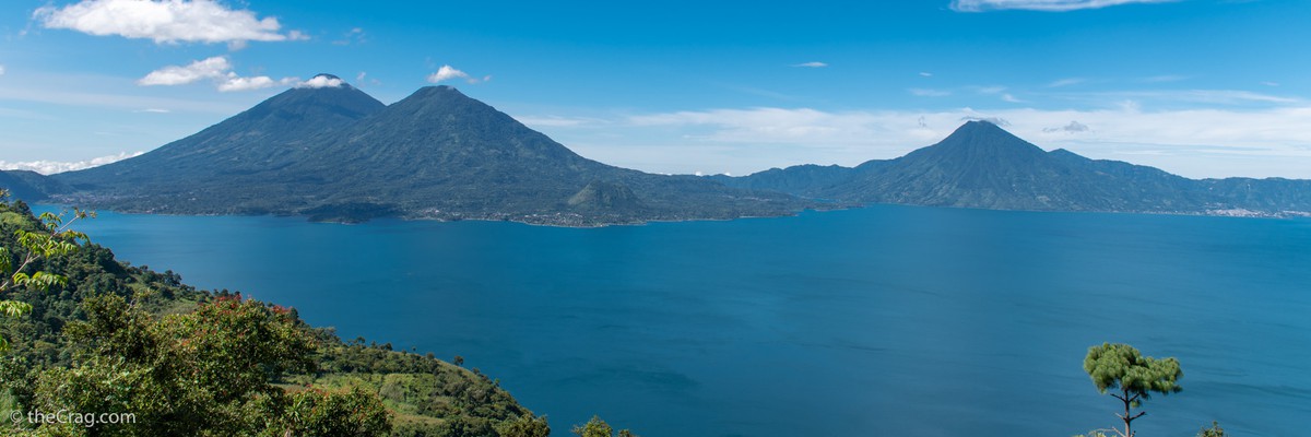
1.2. Santa Cruz La Laguna, Atitlán 6 routes in Crag
- Summary:
-
All Sport climbing
Lat / Long: 14.745148, -91.211571
summary
Santa Cruz is the sole destination on the entire lake where rock climbing enthusiasts can indulge in this thrilling sport.
description
Santa Cruz La Laguna, a vibrant village nestled along the picturesque shores of Lake Atitlán in Guatemala. As Guatemalaescala.org, an NGO dedicated to the development of sports and tourism, we are excited to introduce you to a unique opportunity – rock climbing. Santa Cruz is the sole destination on the entire lake where rock climbing enthusiasts can indulge in this thrilling sport.
Our NGO has embarked on a remarkable project to cultivate the sport of rock climbing in this region. Not only do we aim to offer an exhilarating experience for climbers, but we are also committed to contributing to the economic growth of the local community. By developing this climbing area, we envision creating new avenues for sustainable tourism, fostering job opportunities, and supporting the overall progress of Santa Cruz.
approach
The rock is conveniently located within close proximity to the lakeshore, making it easily accessible for climbers and nature enthusiasts.
From the hotels, it takes approximately 15/20 minutes to reach the starting point of the climbing routes. Currently, there is no signage in place.
To find your way or arrange for guided climbing sessions, simply reach out to our community guide. They possess invaluable knowledge of the area and can provide directions or accompany you to the climbing site. Don’t hesitate to contact them for any assistance you may need, whether it’s understanding the route or organizing a climbing excursion.
By supporting our community guide, you not only enhance your climbing experience but also contribute to the livelihoods of the local community. They are passionate about sharing their expertise, fostering a safe climbing environment, and ensuring your time in Santa Cruz La Laguna is memorable.
Contact: +(502) 3034-6856
where to stay
There are several accommodation options available. Among them, the top choices are La Iguana Perdida, which means "The Lost Iguana" in Spanish, and Free Cerveza.
La Iguana Perdida is a popular lodging option known for its welcoming atmosphere and beautiful location. It offers comfortable rooms, delicious meals, and a range of amenities to ensure a pleasant stay. Additionally, they provide information and assistance for those interested in exploring the rock climbing opportunities in the area.
Free Cerveza, as the name suggests, is another accommodation choice that offers a unique experience. With a laid-back and social vibe, it attracts travelers looking for a lively atmosphere. While staying there, guests can enjoy a variety of amenities and interact with fellow adventurers, including climbers seeking to explore the nearby rock climbing spots.
Both La Iguana Perdida and Free Cerveza have been instrumental in supporting the development of rock climbing in Santa Cruz La Laguna, which is why they are our top choices. Their commitment to the climbing community has made them popular among climbers. However, we encourage people to explore other options by browsing various travel websites and online platforms to find accommodations that suit their preferences. While these two establishments are excellent choices, there are other worthwhile options available that may offer unique experiences and cater to different interests.
history
Guatemalaescala.org NGO has embarked on a remarkable project to cultivate the sport of rock climbing in this region. Not only do we aim to offer an exhilarating experience for climbers, but we are also committed to contributing to the economic growth of the local community. By developing this climbing area, we envision creating new avenues for sustainable tourism, fostering job opportunities, and supporting the overall progress of Santa Cruz.
Nestled amidst the stunning natural beauty of Lake Atitlán, Santa Cruz boasts an awe-inspiring vertical landscape, adorned with an array of challenging cliffs and crags. Climbers of all skill levels can find their perfect routes here, whether they are beginners seeking introductory climbs or experienced climbers yearning for a thrilling challenge. This initiative aims to put Santa Cruz on the map as a premier rock climbing destination, attracting adventurers from far and wide.
1.3. Atitlan - The Yoga Forest 0 routes in Crag
summary
A small climbing area at The Yoga Forest with about 15 routes located high above lake Atitlan.
access issues
Check with Venga Atitlan to book and access this climbing area. In general yoga has priority over climbing and as the yoga and climbing area are very close you might be asked to climb later.
approach
Located above the village of San Marcos La Laguna at the actual yoga camp where you also have to pay.
1.4. Lago Amatitlán 104 routes in Crag
- Summary:
-
Mostly Sport climbing
Lat / Long: 14.492898, -90.606586
summary
An impressive and tall cliff line with mostly great rock quality just 45 minutes from Guatemala City and high above Lake Amatitlán. It is a common destination for climbers that live in La Ciudad.
description
Amatitlán has the highest concentration of routes in Guatemala. For the most part the climbing is technical, crimpy face climbing with amazing views out over the lake. Most routes are single pitch, some have extensions.
Due to its orientation it is best to climb early morning or - when the season permits and it doesn't rain (typically November to March) - late afternoon. You might find routes in the shade any time of the day as some of the cliff faces have slightly different orientation but the rock also becomes pretty hot when exposed to the sun.
approach
Make your way to the north shore of Lake Amatitlán and park in fron of Selvin's small shop ( 14.4906375, -90.6070302). The parking is 5 GTQ.
As for the approach you have two options. Take the short and well maintained trail starting at Selvin's shop (passage is 5 GTQ) that directly leads you to "Sector 0" and "Sector 1". Alternatively there is another path (the original one) going up about 150m before Selvin's shop (just right of one of the pylons of the cable car) that leads to "Sector 4".
See individual sectors for more details.
where to stay
In the past there was a Belay Hostel just opposite of the small shop but it closed down in 2021. It is probably best to find accommodation near the lake or in the city and drive to climb.
1.4.1. Sector 0 6 routes in Sector
- Summary:
-
All Sport climbing
Lat / Long: 14.492676, -90.606587
description
To the right of Sector 1. Considered a different sector because a group of new routes were all aded lately.
approach
Easiest to hike up the trail from the store. You will reach the cliff at ‘Sector 1’. Sector 0 is just to the right of it.
history
One of the newer additions at the cliff, thus also the naming.
1.4.2. Sector 1 26 routes in Sector
- Summary:
-
All Sport climbing
Lat / Long: 14.492544, -90.606968
description
Great climbs on mostly solid rock. The sector offers several short and easy routes but also some harder and longer ones with intermediate anchors. Connects directly with Sector 0 on the right.
The anchors for some of the routes on the left can be reached from the top (‘Sector 2’).
approach
The first sector you reach when hiking up the trail from the store.
history
Sector 1 is also called Las Cucas as Cuca did most of the development.
1.4.3. Sector 2 21 routes in Sector
- Summary:
-
All Sport climbing
Lat / Long: 14.492746, -90.607392
description
Located a bit left and above of Sector 1 this cliff section offers long, technical climbing.
approach
Hike up the trail from the store and keep left once you reach the cliff. The trail climbs to reach a higher cliff band, take a right there to reach the left end of Sector 2.
1.4.4. Sector 3 21 routes in Sector
- Summary:
-
All Sport climbing
Lat / Long: 14.492837, -90.607933
description
The highest density of climbs and the most traffic occurs in this area. This area has seen the biggest development in recent years, you can definitely get a taste of the climbing style in Amatitlan with crimps, technical moves and a little less than vertical angles.
La densidad más alta de vías y el tráfico de escaladores más grande ocurre en esta área. Este sector ha tenido el desarrollo y equipamiento más grande en años recientes, si quieren una muestra del estilo de escalada de Amatitlán este es el lugar indicado con movimientos técnicos, agarres pequeños y ángulos un poco menos que verticales.
approach
Hike up as for ‘Sector 2’ but then follow the trail left. Scramble up a few blocks (with steel bars) to reach this sector. "Manos arriba" and the routes after that are a bit lower on your right before you reach the upper level just below "Entropia".
1.4.5. Sector 4 7 routes in Sector
- Summary:
-
Mostly Sport climbing
Lat / Long: 14.492830, -90.608403
description
This is the first sector developed in Amatitlán. It sees less traffic since the approach started from the store. It is possible to walk around to set up any top rope. Bolts here were originally pegs, all of them hand drilled by self-taught Guatemalan climbers using makeshift gear. The routes are quite short and have been retro-bolted and are well protected.
Este sector tiene la concentración más alta de vías en una única pared, ve menos tráfico desde que el acercamiento desde la tienda de Julio se abrió. Es posible escalar por atrás para montar cualquier yo-yo. Las chapas eran originalmente pines, los agujeros abiertos a mano por guatemaltecos auto didactas usando equipo improvisado. Las vías son bastante cortas y han sido re equipadas con chapas y están bien protegidas.
approach
Hike up the original approach trail to directly reach this, a bit lower situated, sector or hike down from the other sectors.
1.4.6. Sector 5 10 routes in Sector
- Summary:
-
All Sport climbing
Lat / Long: 14.493090, -90.608376
description
Located just left of ‘Sector 3’ on different levels. Some climbs have a fairly decent amount of shade, even later in the day. This area has lots of potential for bolting long pitches and mixed climbs, the rock is just waiting for someone with a cleaning brush who envisions the lines. Maquina del tiempo is a clear example of the climbs that can be bolted in this area.
Algunas vías tienen una cantidad de sombra decente. Esta área tiene mucho potencial para equipar vías largas y vías mixtas, la roca solo está esperando por alguien que tenga un cepillo para limpiar y que tenga la visión. Máquina del tiempo es en claro ejemplo de las vías que se pueden armar en esta área.
approach
Same as for ‘Sector 3’ and then a few meters left and up.
1.4.7. Sector 6 13 routes in Sector
- Summary:
-
Mostly Sport climbing
Lat / Long: 14.492943, -90.607618
description
The highest crag at Amatitlan it has the best views out over the lake and a cool chimney to approach.
approach
Approach as for ‘Sector 3’ and then make your way up the chimney on the right.
1.5. Pacoc 0 routes in Crag
1.6. Cerro Mirandilla 0 routes in Crag
summary
Some sport climbing on top of the mountain.
approach
Coming from Guatemala City towards the Pacific Ocean when reaching the restaurant Sarita, there is a way to go back to Antigua (towards Autodromo). Once you take this road you’ll be able to see a big mountain with a rocky summit. The place has a parking lot and you have to pay a small fee to go in.
1.7. La Ventosa 0 routes in Field
description
Blocks located on the trail for La Torre.
approach
A few kilometers after passing the town of Chiabal where the road starts to drop into the valley yo will find this boulder paradise.
1.8. Urlanta Falls 0 routes in Crag
summary
Urlanta waterfalls is about 70 meters high and fed with fresh water from the mountain. Rappel and rock climbing can be practiced near the waterfall.
1.9. La Peña del Ángel 0 routes in Crag
summary
An undeveloped area with potential for climbing and bouldering.
1.10. Rio Dulce Canyon 0 routes in Crag
summary
A great area for Deep Water Soloing! One of the walls became famous as it was used for the shooting of the first Tarzan movie.
approach
By boat from Rio Dulce or Livingston.
1.11. Roca de Jutiapa 10 routes in Crag
- Summary:
-
Mostly Sport climbing
Lat / Long: 14.421875, -89.717230
summary
A small climbing area with 2 sectors, one overhanging with harder routes facing west and a vertical one with easier climbs facing east.
description
A relatively recent addition to climbing in Guatemala with some of the hardest routes in a scenic and quiet setting.
The crag has two sectors that are reached via different approaches (see each sector for details). The easier, east facing once can be seen from Don Fernando's ranch, the overhanging one is located around the corner on teh same hill.
approach
Make your way to the town of Jutiapa. From there follow the road in direction of Ipala. Shortly after the bridge that crosses the river (Rio Otsua O Grande) at (GPS14.4361030, -89.7269213) a small concrete road climbs up on your right. From there it is about 3.2km to Don Fernando's ranch. Follow the road uphill and then flat for 2km at which point you reach a T-junction. There take a right for 1.2km until you see a church (in construction) on your right. This church is already on Don Fernando's property. Follow the road for a bit more until you see the entrance on your right (GPS14.4223208, -89.7122781).
where to stay
You may stay and camp at Don Fernando's ranch.
ethic
The climbing is located on the property of Don Fernando who generously allows access for free. Please respect the owner and ensure that access stays open. Carry out all trash, close gates and avoid disturbing the many farm animals.
history
Luis Girón who is a climber who grew up in Jutiapa, found the crag and together with David Galindo bolted the first routes here.
1.11.1. La Roca de San Vicente 5 routes in Cliff
- Summary:
-
All Sport climbing
Lat / Long: 14.421113, -89.719690
description
Small crag but probably with the best and hardest rock in Guatemala as of the time of me writing this. Overhanging conglomerate (mainly pockety). Named after Monse, a daughter of Don Fernando.
approach
From Don Fernando's farm, is about 40 min of hiking. From the house pass behind the pond and follow the dirt road to the right at the base of the hill. After about 10 minutes the road will start descending, continue until you see an open meadow on your left. Look out for a faint trail that crosses this meadow towards the forest (staying at the same level, you will also see the cliff further up the hill). Just before you enter the forest, follow a well marked trail up on the edge of the forest to the upper right corner of the meadow where you will see a well marked trail going in right and steeply up towards the cliff.
history
David Galindo is most likely the only 8b+ climber in Guatemala and has been lately looking for hard routes. Luis Girón (IG: Luis giron) who is a climber who grew up in Jutiapa, found the crag and together with David, bolted the first routes here.
1.11.2. Cara este 5 routes in Cliff
- Summary:
-
Sport climbing and Bouldering
Lat / Long: 14.421413, -89.715330
description
A small cliff with a handful of easier routes that you can see from Don Fernando's ranch.
approach
Walk passed the pond and take the first left through a cattle gate. Follow the faint trail(s) uphill to reach the cliff.
1.12. Casa Boulder 0 routes in Gym
summary
Bouldering gym in Guatemala City
description
A great place to meet local climber and get all the info on where to climb in Guatemala. Imagine if you converted your house into a bouldering gym - that's what Casa Boulder is. It's not just a place for locals to train mid week, it's also a social spot. If you need a place to stay they can hook that up too.
1.13. Qubo Antigua 0 routes in Gym
summary
The newest bouldering gym in Guatemala. More than 50 standard routes and over +3000 thanks to the Tension Board
approach
Located in Antigua Guatemala
1.14. Venga Atitlan Outdoor Adventures 0 routes in Gym
summary
Bouldering wall with yoga, paddleboarding, and other outdoor tours.
description
Bouldering wall with yoga, paddleboarding, and other outdoor tours. Small wall but brand new with great routes. The owners Jonas and Michelle are wonderful. This is a must for climbers visiting Atitlan