Seasonality
Summary
Igneous Plutonic
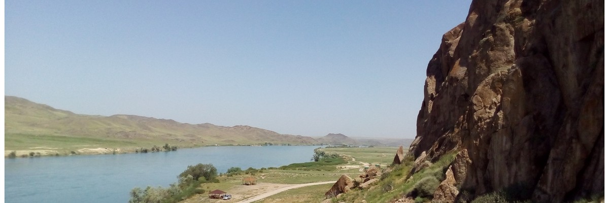
Dozens of sport and trad routes at the banks of Ili River.
Description
Somewhere in the flat steppe, the rock-addicted may find a relief: Tamgaly-Tas, some of the sights in Almaty's surrounding, besides a Buddha-rock painting and a yearly folk-music festival boast some diverse rocky outcrops.
The climbing varies from slabs, face to some cracks. Pro is as diverse - there are mostly modern sport routes, although there are also some trad routes. In some places there are still old bolts with homemade hangers, which should be avoided. Wearing a helmet is recommended, as the rock tends to shed flakes even where it looks quite solid.
Tamgaly-Tas is comfortable when the weather is good, but hell (or Hoth) in the wrong conditions. The season runs from March to mid-May, and then again from mid-September to November. Summer is considered too hot to climb, and there are clouds of bloodthirsty insects. The air tends to be still, so it's lovely in the sun in cooler weather, but absolutely stifling when the weather's warm. Conversely, humidity is low, so the shade is comfortable in warmer weather. Luckily there are areas facing every direction, so you can always find somewhere in the shade or sun to climb.
Almost all the recent development has been done by Kirill Belotserkovsky, who has bolted or rebolted almost a hundred routes. Anyone who has enjoyed climbing at Tamgaly-Tas is encouraged to contribute the bolting fund.
Kirill has also made a detailed guidebook.
Access issues
A large sandy patch normally forms on the usual access road at (44.083491, 77.022340), about 5km from the crag. With a 2wd, you should consider taking one of the alternate roads.
There is a gate at the entrance to the climbing area. As of 2020 the wardens don't seem to mind if you just walk through and climb. They will, however, charge a fee if you drive in, or camp inside the fence.
Approach
<5 min
Drive from Almaty to Qapshagai (43.889201, 77.070354), continue North over the dam and Ili river for 8 km. At the interchange (43.928013, 77.143952) turn North (left) towards Bakhbaty. After 15 km (44.095517, 77.065609) turn West (left) onto a dirt road (there is a small sign). Take the system of parallel paths to the west towards the river valley and follow it upstream until you spot the rocks. This route is normally fine with a 2WD if you drive carefully (see "Access issues").
There are several other paths to the river, for example by turning off the highway earlier (44.027847, 77.093741). These might be better for a 2WD. It seems that despite the state of the roads, many tourists seem to manage with 2WDs.
Where to stay
People pitch their tents in the surroundings. Carry out all rubbish and use a gas stove. There is a toilet in the middle of Gavan.
Ethic
New route potential
Well established
There were some dodgy ethics in the past (chipped and glued holds), but the crag is now being developed as a modern sport crag, with respect for trad lines.
There is still plenty of space on Tamgaly-Tas rocks. There is a place for sport routes, multipitches, and trad lines. If you live or travel in the area and decide to put a route:
- Use best materials available, i.e. stainless steel glue-in bolts and appropriate glue (Hilti Hit RE-500, Hilty Hit HY-200 or similar). The second option—expansion stainless steel bolts. If you don’t have access to suitable gear, please don’t bolt anything.
- Contact the locals - that is Kirill Belotserkovsky on Facebook or at kirill@steelinside.com - to discuss a sector and a line.
- Don’t bolt obvious cracks! Cracks could be done on gear, so consider doing them in the best style you (or those stronger than you) can.
If you don’t want to deal with drills, dust, and glue but want to join the process of development of the area, donate some money. One route costs approx $100, but you don’t need to transfer all the sum. Even a small donation will allow the locals to buy more bolts and set more safe routes.
Tags
Plan your Trip
Hello!
First time here?
theCrag.com is a free guide for rock climbing areas all over the world, collaboratively edited by keen rock climbers, boulderers and other nice folks.You can log all your routes, connect and chat with other climbers and much more...» go exploring, » learn more or » ask us a question


Accommodations nearby more Hide
Share this
Nearby Icons
| 6b | ★★★ Remeslo | ||
| 7a+ | ★★★ Коперник |
Photos Browse all photos

Tamgaly-Tas - IMG_20201018_174026556_2.jpg

Riverside - Sectors towards Ili river

Zamanka - IMG_20201017_092950067_HDR.jpg
Fri 26 May
Check out what is happening in Tamgaly-Tas.
Get a detailed insight with a timeline showing
- Ticks by climbers like you
- Discussions of the community
- Updates to the index by our users
- and many more things.
Login to see the timeline!