Use this Region Guide to easily find and compare Crags.
Table of contents
- 1.
Gyeonggi-do & Seoul / 경기도
777 in Region
-
1.1.
Insubong / 인수봉 93 in Crag
- 1.1.1. Insubong Crag 93 in Crag
- 1.1.2. Insubong Campsite Boulders 0 in Crag
-
1.2.
Baekeundae-amjang / 백운대 암장 20 in Crag
- 1.2.1. Baekundae Cracks / 백운대 크랙 6 in Sector
- 1.2.2. Baekundae Slab Center Wall / 백운대 슬랩 중앙벽 6 in Sector
- 1.2.3. Baekundae Slab Right Wall / 백운대 슬랩 웁벽 8 in Sector
-
1.3.
Dobong-san / 도봉산 58 in Crag
- 1.3.1. 자운봉 / Jaunbong 1 in Crag
- 1.3.2. 연기봉 / Yeongibong 2 in Area
- 1.3.3. 선인봉 / Seonin Bong 3 in Area
- 1.3.4. Seonin-bong / 선인봉 42 in Crag
- 1.3.5. 신선터 7 in Crag
- 1.4. Aman-bawi / 아만바위 11 in Crag
- 1.5. Bulam-san, Hakdo-am / 불암산 학도암 27 in Crag
- 1.6. 불곡산 독립봉 암장 / Bulgok-san, Doklibbong-amjang 25 in Area
- 1.7. Chilbo-amjang / 칠보암장 18 in Crag
- 1.8. Dwaejigul-amjang / 돼지굴 13 in Cliff
- 1.9. Gahaksan-amjang / 가학산 암장 12 in Crag
- 1.10. Gamak-san, Seolgwi-am / 설귀암 12 in Cliff
- 1.11. 거인암장 / Geoin-amjang 26 in Crag
-
1.12.
Gwanak-san / 관악산 46 in Area
- 1.12.1. Bausarang-amjang / 바우사랑암장 13 in Cliff
- 1.12.2. Gwanak-amjang / 둘이서 하나되어 암장 / 관악암장 17 in Cliff
- 1.12.3. Nocles-amjang / 노클스암장 16 in Cliff
- 1.12.4. 아람월 0 in Area
- 1.13. Hamheudongcheon-amjang / 함허동천암장 16 in Cliff
- 1.14. Hanagae-amjang / 하나개암장 39 in Cliff
- 1.15. Jobi-san, Jobi-am / 조비암 44 in Cliff
- 1.16. Jongjasan / 종자산 1 in Crag
- 1.17. Morak-san, Mirae-am / 미래암 29 in Cliff
- 1.18. Muakjae Ansan-amjang / 무악재 안산암장 31 in Cliff
- 1.19. Myeongsung-san, Chak-bawi 0 in Cliff
- 1.20. Namhansansung, Beomgul-am / 남한산성 범굴암 17 in Cliff
- 1.21. Nojeokbong / 노적봉 28 in Crag
- 1.22. Obong-san, Byeongpung-am / 오봉산 병풍암 12 in Cliff
-
1.23.
Samseong-san / 삼성산 124 in Crag
- 1.23.1. Buhwal-amjang / Resurrection Rock / 부할 암장 15 in Crag
- 1.23.2. BAC / Byeongpung-Bawi / 병풍바위 20 in Cliff
- 1.23.3. Dokkeobi-amjang / 도꺼비암장 0 in Cliff
- 1.23.4. Ilbong-amjang 20 in Crag
- 1.23.5. Inkeul-amjang / 인클암장 18 in Cliff
- 1.23.6. Mudanggol-amjang / 무당골암장 0 in Cliff
- 1.23.7. Sumeun-am / Hidden Crag / 숨은암 31 in Cliff
- 1.23.8. Yong-amjang / 용암장 20 in Area
- 1.24. Seodaemun Ansan Amjang 0 in Crag
- 1.25. Sori-san, Samhyeongjae-bawi / 소리산 삼형제 바위 35 in Cliff
-
1.26.
Surak-san / 수락산 23 in Area
- 1.26.1. Daeju-amjang / 수락산 대주암장 13 in Crag
- 1.26.2. Naewon-am / 수락산 내원암 10 in Cliff
- 1.27. Suri-san, Mae-bawi / 매바위 17 in Cliff
- 1.28. Suji Climbing / 수지클라이밍 0 in Gym
-
1.1.
Insubong / 인수봉 93 in Crag
1. Gyeonggi-do & Seoul 777 routes in Region
- Summary:
-
Sport climbing, Trad climbing and other styles
Lat / Long: 37.605100, 127.016316
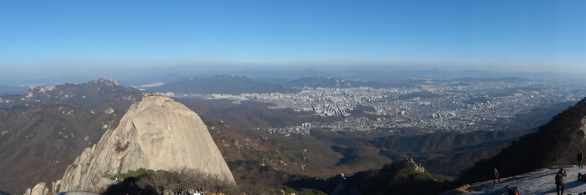
1.1. Insubong 93 routes in Crag
- Summary:
-
Trad climbing, Sport climbing and other styles
Lat / Long: 37.658817, 126.981048
summary
Massive granite peak right outside of Seoul. On weekends it gets very busy so be prepared for large crowds of people on the easier/classic routes.
description
Routes are primarily slab and cracks with a few face and chimney climbs in between. Climbs range from one to eight pitches. The highest graded route is My Way(5.12b).
access issues
Korean National Park -- No smoking in the park and no open fires.
approach
Take the UI-Sinseol line to Bukhansan Ui Station. Come out of Exit #2 go up the hill until you find taxis waiting on the side of the road. These taxis take people to the trailhead for 2000won per person and typically wait until full. The hike from the trailhead is about half an hour to an obvious ranger station. From the ranger station, hike up and above the hermitage on the right. There is a small trail that goes around the hermitage and continues up past some boulders to the base of Insubong. The hike up from the ranger station to the base of Insubong is rougly twenty minutes.
1.1.1. Insubong Crag 93 routes in Crag
- Summary:
-
Trad climbing, Sport climbing and other styles
Lat / Long: 37.658817, 126.981048
summary
Giant Granite Peak Variety of difficulties up to 5.12
description
This is one of the most iconic climbing areas in all of Korea. A large variety of multipitch trad routes as well as many great sport routes dotted along the base. Routes are primarily slab and cracks with a few face and chimney climbs in between. Information currently being updated to be aligned with plaque at base of the wall.
approach
See Insubong approach. Some routes start at the 'Oasis' which is the large green section in the middle of the wall. You will need to climb a slab route to get here. Pitch one of Chouinard B will take you to the oasis if you go left after the crack.
ethic
To descend, either rappel the route or summit the peak. The summit can usually be reached by going up the upper slabs. Protection may vary. After you summit, you can go to the south side, follow the chains and go down the furthest right anchor. Rappel Pigeon Road. (2 30m rappels will make it. If you do not use the correct anchor you may end up short.)
history
Note from editor: I have been trying to compile as much info as I can from old guidebooks and blogs. The information is scarce and mostly in Korean. I will try to update the routes to be as accurate as possible but you may notice some differences when you hit the wall. Please feel free to update any info or contact me with anything you find or have!
1.1.2. Insubong Campsite Boulders 0 routes in Crag
summary
Note This information is out of date. There are many boulders around the base of Insubong including some v10+
description
The rock here consists of a worn granite, not smoothed by glaciation, but sharp with crystals. Some boulders sport bomber edges, some boulders beg serious cleaning time in order to remove the crumbly dirt and crust encasing some of the holds. But everything you want is here, from overhung roofs, highball scare-fests, dynos, V11 testpieces, excellent slabs, fun and interesting warm-ups and plenty of exploring and adventure -- all placed just beneath Insu Peak, and scattered around a quant Buddhist temple
approach
Getting to Insubong is just a matter of bus and subway hopping (isn't everything in Seoul?). You can catch the 144, 109, 120, etc (I don't know all the buses and where you can catch them, so I won't spend time guessing) and they should take you directly to a market street just below the peak. You can also take the Blue Line to Suyu St. and jump on a 109 or 144 from there.
Next, you can either hike up to the trailhead (a lengthy, steep jaunt on asphalt), nab a taxi, or await the free bus running up and down the mountain all day. You'll wait across the street from the Black Yak in a large parking area. The buses have a cartoonish painting of Buddhist Monks, and yes, they will store your crash pads under the bus for the ride up and down.
After you're at the top, you'll have the opportunity to stock up on some water, kimbop, etc, and then head up the stone steps and begin the 20 minute hike to the boulders. I believe it costs 1400W or something close to that, to get into the park. Follow the trail, which will be utterly congested with hikers, all the way to the campground.
1.2. Baekeundae-amjang 20 routes in Crag
- Summary:
-
Mostly Trad climbing
Lat / Long: 37.658327, 126.977804
summary
This granite crag is on the south side of Baekundae, just below the peak. A good place to go to avoid the crowds on the adjacent Insubong.
description
The routes here vary from cracks, slab and some with a few roof moves. There are single pitch crack climbs and the right wall has low grade practice slabs with bolted anchors. There are also various multipitch routes, some with harder sections through roof features. This area is maintained by the Kolon Alpine School.
approach
From Bukhansan-Ui station, take exit 2 and head up the hill until you see taxis waiting on the left side. Take a taxi up to the trailhead. (the cost is 2000 won per person cash and the taxi driver will go once the car is full.) Take the trail for Baekundae peak. Once you are just below the peak you can take any of the various side trails off into the forest and reach the base of the slabs or if you go a little higher to the top of the treeline you can descend from the left side where the cracks are. The hike from the trailhead takes approximately 1.5 hours.
history
In September 2021 the Kolon Alpine School rebolted the anchors and developed some routes. There is still some potential for further routes.
1.2.1. Baekundae Cracks 6 routes in Sector
- Summary:
-
All Trad climbing
Lat / Long: 37.658439, 126.978707
description
Left of the Baekundae slabs there are these short but nice crack features. All routes have bolted anchors. Potential for extensions of a few routes into more offwidth terrain.
approach
Left of the large slab. Can be easily reached from the Baekundae peak trail.
descent notes
Gear to 4"
1.2.2. Baekundae Slab Center Wall 6 routes in Sector
- Summary:
-
All Trad climbing
Lat / Long: 37.658574, 126.978936
description
The left side of the big slab below the peak.
1.2.3. Baekundae Slab Right Wall 8 routes in Sector
- Summary:
-
Mostly Trad climbing
Lat / Long: 37.658639, 126.979124
description
The lower section of the slab below the small roof.
1.3. Dobong-san 58 routes in Crag
- Summary:
-
Trad climbing, Aid climbing and other styles
Lat / Long: 37.695021, 127.009570
summary
Multipitch routes near Seoninbong without the crowds
approach
Follow trails to Seoninbong from the main park entrance. When you reach the last bathroom, the trail continues behind the bathroom. Follow sings for Juanbong throughout.
1.3.1. 자운봉 1 route in Crag
- Summary:
-
All Trad climbing
Lat / Long: 37.699120, 127.017426
summary
Smaller wall in the Seoninbong area
access issues
Water points can be found along the hike in the park. The nearest water point to the wall is at the monastery.
approach
After hiking about 30m above the monastery, look for a small open carabiner painted on the fence. This is the entrance to the base of the crag.
1.3.2. 연기봉 2 routes in Area
- Summary:
-
All Trad climbing
Lat / Long: 37.699189, 127.018715
description
등반로에서 바라봤을 때 맨 오른쪽 봉우리.
1.3.3. 선인봉 3 routes in Area
- Summary:
-
All Trad climbing
Lat / Long: 37.696776, 127.017551
1.3.4. Seonin-bong 42 routes in Crag
- Summary:
-
Aid climbing, Trad climbing and Sport climbing
Lat / Long: 37.696775, 127.017547
summary
Seoninbong is another prolific climbing area in Seoul. Routes are very similar to Insubong.
description
Most routes are trad climbs with some aid sections required to navigate the blank granite.
1.3.5. 신선터 7 routes in Crag
- Summary:
-
All Sport climbing
Lat / Long: 37.693513, 127.008659
summary
한국 알프스 산악회 연습용 바위에 볼트를 교체하는 과정에서 새로운 루트를 더 개척하여 오픈한 암장
1.4. Aman-bawi 11 routes in Crag
- Summary:
-
All Sport climbing
Lat / Long: 37.611762, 126.484067
description
This area has been quarried out leaving behind 3 climbing walls. The main wall has been documented more whilst the other two are still in development. The routes range from 5.8 to 5.11c. Facing SSW with a stream running nearby and featuring some faces and exciting overhangs, this crag offers a fun day out.
Some of the rock can be sharp, loose and slippery so climb with caution.
Please note, the information on this crag was taken from http://blog.daum.net/k-climber/1179 and translated by me for TheCrag.com
access issues
If the car gate is closed, just walk up the left road and enter in the gap of the trees.
approach
By car or taxi, travel to KT&G Training Centre (798-18 Haeannam-ro Gilsang-myeon, Ganghwa-gun, Incheon). Try to avoid busses as the waiting times are unpredictable. At the entrance the to KT&G, you can walk up the tar road to the sign, Picture 4. It is a gentle 700m (half-mile) walk along a trail to the crag. After 500m, look out for the side trail on the right once the path seems to marge with the stream otherwise you'll be pushing through vegetation.
history
It is said that the route name was named as follows in honor of the death of Mr. Gilsoo Yoon's mother at the time of pioneering.
1.5. Bulam-san, Hakdo-am 27 routes in Crag
- Summary:
-
All Sport climbing
Lat / Long: 37.654830, 127.089848
summary
슬랩 위주로 되어 있는 암장. 한성대학교 산악회에서 개척.
approach
학도암에서 등산로를 따라 15분 정도 가면 나옴.
1.6. 불곡산 독립봉 암장 25 routes in Area
- Summary:
-
Sport climbing, Aid climbing and Trad climbing
Lat / Long: 37.800524, 127.025632
summary
개척자: 이주홍, 송우근씨 주측으로 익스트림 라이더 등산학교 동문이 참여했다. 4년에 걸쳐 개척되었으며, 2019년 10월 개척보고회를 가졌다. (출처: 월간 사람과 산 2019년 12월호)
description
스포츠 클라이밍 루트와 인공 등반, 트레드 클라이밍을 할 수 있는 암장
approach
경기도 양주시 부흥사로 주소를 찍고 오면 된다. 주차는 부흥사 도착 전에 있는 공터에 할 수 있다. 주차장이 협소하므로 차량 수를 적게 하는 것이 좋다.
history
2019년 10월 개척보고회
1.7. Chilbo-amjang 18 routes in Crag
- Summary:
-
Mostly Sport climbing
Lat / Long: 37.254666, 126.935980
summary
A crag located in Suwon on Chilbosan
description
This is a short crag located in West Suwon. It is rather short with a short approach. The crag was updated in 2021 with new bolts and routes. There is a plaque with all route at the crag.
approach
Head to the Chilbosan Prayer House. 100m before coming to the monastery, there is a large bird house and a hydro pole. There is a white ribbed ribbon. Follow that trail for about 10 minutes and you will see a crag.
1.8. Dwaejigul-amjang 13 routes in Cliff
- Summary:
-
All Sport climbing
Lat / Long: 37.269336, 127.390828
description
The crag is located on Doderum-san’s 도드람산 fourth peak. Dwejigul-amjang 돼지굴암장 was developed in 2003 and has thirteen routes with one crack route in the middle that can be trad climbed. Most of the routes are angled between 80 to 120 degrees and the rock is very solid. Dodeuram 도드람 means “crying wild boar”. Legend has it that one day, when a monk was collecting mushrooms at this crag by hanging from a rope, he heard a crying boar at the top of the crag. He climbed up to investigate and when he reached the top, the monk found that his rope was almost cut through by the rock. He looked for the boar that had saved him, but it was gone. Since then, people started to call this mountain Dodeuram-san 도드람산.
approach
From either Dong-Seoul Bus Terminal 동서울버스터미널 or Gangnam Highway Bus Terminal 강남고속버스터미널, take an intercity bus bound for Icheon 이천. Get off at Icheon 이천 and transfer to a bus bound for Yongin 용인. Get o at Pyogo Elementary School 표고 and then walk for fifteen minutes to the SK Training Center. From the SK Training Center, you can see the ve peaks lined up on the mountain. There are two main trails to get to the crag. The middle trail will lead you up to the ridge, but the east trail has an easier approach. Follow the hiking map, at the trailhead, and the signs to the fourth peak. The crag is right below the peak on the east side. It will take thirty minutes to reach the crag from the trailhead
descent notes
Gear 7 draws, a 50m rope, and a set of small to mid-sized cams if you prefer placing protection. Additional Comments Close to this crag, there is another potential wall that will be developed sooner or later. is seldom-visited area is a pleasant thirty minute hike that offers a lot of sunshine and open space on the rocky ridge.There is also some nice bouldering if you look around the area.
1.9. Gahaksan-amjang 12 routes in Crag
- Summary:
-
All Sport climbing
Lat / Long: 37.427956, 126.866463
summary
Gahaksan is a small granite crag close to Seoul near Gwangmyeong Cave.
description
The crag was mostly rebolted in 2019.
approach
Take bus 17 or 77 from Anyang to Gwangmyeong Cave.
1.10. Gamak-san, Seolgwi-am 12 routes in Cliff
- Summary:
-
All Sport climbing
Lat / Long: 37.941497, 126.957414
description
This crag is composed of an overhanging upper section and a vertical faced lower section on granite rock that faces south. It offers crimpy face climbing with some blunt holds. Most of the routes, including the crack climb, are sandbagged. This crag is located next to the main hiking trail, so the hikers may be distracting during the weekends, but the rock quality is good.
approach
From Euijungbu City Bus Terminal 의정부, take the bus bound for Jeokseong 적성 and get off at Beomryun-sa Temple 범륜사. It will take an hour. At the bus stop, walk up to the temple. Continue on the main trail for forty minutes until you see the Rescue Mark 3-3, that is located next to a spring. The crag is right by the trail, 200m after the mark.
descent notes
Gear 10 draws, a 50m rope, and a full set of cams Additional Comments Water should be readily available at the spring. There are good campsites around the crag.
1.11. 거인암장 26 routes in Crag
- Summary:
-
All Sport climbing
Lat / Long: 37.927057, 126.899970
summary
경기도 파주 파평산에 있는 암장. 바로 옆에 타이거 CC 가 있어 찾기 쉬움.
1.12. Gwanak-san 46 routes in Area
- Summary:
-
All Sport climbing
Lat / Long: 37.437440, 126.976937
summary
Gwanak-san is a popular sport climbing area in Southern Seoul. There are many crags on the sides of this mountain as well as the neighboring mountain, Samseong-san.
description
All of the crags are granite from slab to overhanging.
approach
The approaches are often short and detailed in each crag.
1.12.1. Bausarang-amjang 13 routes in Cliff
- Summary:
-
description
I have linked a Korean blog to the location of this cliff. https://kjcjkj.tistory.com/15714593
1.12.2. Gwanak-amjang 17 routes in Cliff
- Summary:
-
Lat / Long: 37.437466, 126.976958
description
This crag was developed in 1991 and has seventeen routes. The climbs here are less than 13m and offer face, crack, and overhanging climbing on excellent granite stone. It can be reached within half an hour from the subway station and gets sun all day.
approach
At Gwachun Subway Station 과천 (Line #4), take Exit 7. Head towards Gwachun Middle School 과천중학교. Pass the middle school and walk up to the park o ce. It will take fifteen minutes from the subway station. Continue to hike on the main trail for another fifteen minutes until you reach a wooden bridge. The trail will start to ascend steeply. After a few minutes of hiking, you’ll see the crag to your left. Cross the valley and scramble up to the crag.
Take subway line 4 from Seoul to Gwacheon Station. Leave the station through exit 7, and walk up the road until you dead end at the river road. Take a left, and walk until you see the park entrance on the right. Go up the main trail until you see two large signs (I uploaded a picture) on the left of the trail. There are stone steps right after the signs. Turn left just at the foot of the stairs. Cross the river on the boulder walk, and follow the trail for about 20 meters to the crag.
descent notes
Gear 7 draws and a 50m rope. Additional Comments There are a few campsites around the crag. Water and snacks should be bought before getting on the main trail.
1.12.3. Nocles-amjang 16 routes in Cliff
- Summary:
-
Lat / Long: 37.443759, 126.958797
description
This crag offers challenging overhanging climbs on granite rock.The grades are a little sandbagged. It faces west and gets shade all day. The rock is very solid.
approach
From Seoul National University Subway Station (Line #4), take Exit 3 and walk towards Gwanak-san Park 관악산공원. Continue on the main trail until the Rescue Mark K59, past the wooden bridge. Walk down and right to the valley at the end of the small wooden bridge.The crag is underneath the main trail, right before the bridge. Total approach time from the subway station will be fifty minutes.
descent notes
Gear 10 draws and a 50m rope. Additional Comments the crag will be in the shade all day, even in the summer. The belay station o ers good campsites.
1.12.4. 아람월 0 routes in Area
1.13. Hamheudongcheon-amjang 16 routes in Cliff
- Summary:
-
All Sport climbing
Lat / Long: 37.613629, 126.448179
description
This crag lies on the most sacred mountain in South Korea, where the legendary founding father of ancient Korea used to hold a memorial service for Heaven. It was developed in 2010 with sixteen routes. It is small, but this crag offers hard climbs on a slabby face with thin cracks in all the corners of the routes.The rock is good quality and is the perfect place for practicing cam placements. It faces east, but is shaded by the trees all day.
approach
From Seoul, take a bus to Ganghwa Bus Terminal 강화 and then transfer to a bus bound for Hamheudongcheon 함허동천. Get o at Hamheudongcheon. At the bus stop, walk to Hamheudongcheon Campgrounds and stay le on the main trail, past the ticket counter. After a ten minute hike from the ticket counter, you will reach a white, rectangular water tank on your le . Go left around the tanker and if you look closely, you will see a path and a black wooden sign with a cross. Follow this path for five minutes and the crag will be on your right.
descent notes
Gear 7 draws, a 50m rope, and a set of cams with extra small cams. Additional Comments Hamheudongcheon is one of Korea’s biggest campsites with lots of facilities and good scenery.
1.14. Hanagae-amjang 39 routes in Cliff
- Summary:
-
All Sport climbing
Lat / Long: 37.376682, 126.409358
Take a taxi directly to the Hanagae Beach 하나개 from Incheon International Airport Terminal 1 (1st floor). Takes 20 minutes, around 15.000 won. You'll probably not find a taxi for the return, but you could take the bus & maglev.
For return: take bus no.1 to the Maglev station: Yongyu station (first station) and take it directly to Incheon International Airport Terminal 1 (end station) - 5 stops, approx. 15 min. It is free of charge.
description
Located at Hanagae Beach 하나개 in Mueuido 무의도, the crag is divided into three areas within less than 200m of each other. Most of the routes are facing west with a unique setting. High tide usually comes around 3 p.m. and lasts about an hour, so most of the areas are climbable all day. Many of the routes can be top-roped.
approach
From Seoul, take a bus or train to Incheon International Airport. Exit from Gate 6 and take a bus bound for Jangjindo 장진도 or take buses bound for the entrance of Mueuido 무의도 and walk twenty minutes to reach Jangjindo. Buses bound for Jangjin-do run every hour and will take you straight to the ferry dock. However, instead of waiting for an hour, it will be faster to take the bus bound for Mueuido Entrance 무의도입구 because the bus runs every ten minutes. Get on a ferry for Mueuido at Jangjindo dock. Hanagae Beach can be approached by either a bus or by walking through the mountain trail from the village 큰무리, where you get to the ferry.
Update 09.06.2019: The island is now directly accessible by taxi since there was a bridge opened to the island.
To access the crag from Hanagae Beach, take the path that is on your left as you face the sea. Continue walking along the sea for twenty minutes, past a couple of wooden fences, until you see guide ropes heading down to the crag at sea level. When the tide is low, it can be reached by walking along the seaside. The approach time from the ferry dock will be an hour.
descent notes
Gear 12 draws and a 50m rope. A set of cams can be used on some of the routes. Safety Although the crag is a sea cliff , it is good quality stone. Additional Comments There are tons of amenities at the beach and great campsites around the crag.
1.15. Jobi-san, Jobi-am 44 routes in Cliff
- Summary:
-
All Sport climbing
Lat / Long: 37.117932, 127.368430
description
Jobi-am 조비암 has a plethora of nice roof routes above the cave, which is located in the center of the crag. It also offers both easy and hard face routes on either side of the cave. The crag is in the sun all day because it faces directly south. The hard roof routes above the cave were added recently. The crux on the roof easily disappears after a couple of hard pulls. Most of the routes have names and grades painted at the bottom. The bolts look very good and the rock quality, for the most part, is excellent. Two easy traditional climbing routes were also established on either side of the cave, where you can place a few cams if you would like to ignore the bolts on the routes.
approach
From Seoul, take a bus to Yongin Bus Terminal 용인. From Yongin, transfer to a bus bound for Baekam 백암. At Baekam Bus Stop, take a bus heading towards Jangpyeongsamgyeri 장평삼거리. From there, walk straight for five minutes on the road and hike to Jobisan Garden Restaurant 조비산가든. Continue on the unpaved road for fifteen minutes. The crag can be seen all the way from the bus stop.
descent notes
Gear 10 draws and a 50m rope. Bring some trad gear if you want to practice placing pieces on the multi-pitch routes. Safety For the routes on the far right side, a helmet is recommended. Additional Comments When the weather is bad, local climbers camp out in the cave, which is large enough for two or three tents. However, there is a spacious area in front of the cave for pitching tents as well. Water and food should be bought at the bus terminal.
1.16. Jongjasan 1 route in Crag
- Summary:
-
All Sport climbing
Lat / Long: 38.105073, 127.195089
access issues
This crag has been closed as the landlord got upset with climbers!
approach
Location is approximative.
1.17. Morak-san, Mirae-am 29 routes in Cliff
- Summary:
-
All Sport climbing
Lat / Long: 37.367798, 126.973837
description
Located in Uiwang-Si 의왕시, Mirae-am 모락산미래암 has thirty routes. It’s 10m high and 100m wide. This crag was established in 1992. It has a metamorphic rock texture and angles ranging from 80 to 135 degrees, which makes it ideal for strengthening finger muscles and working on hard, technical moves. All the climbing here is intense, including the easier routes. there is a diagram on the first route with grades for each climb.
approach
From Gumjung Subway Station 금정역, take a bus heading for Shinwon Rotary 신원. Get o at Uhan-Kimbery 유한양행. From Uhan-Kimbery 유한양행, walk towards Hyoseong Elementary School 효성초등학교. Continue past the elementary school, between Jindallae Apartment 진달래 and Shinwon Apartment 신원. Cross the road at the lights after these apartments. There is a spring for water by Hangwang Shine Hill Village Apartments 한광. Hike up the main trail for twenty minutes. After walking up a couple of wooden stairs, there is a Rescue Mark 1-5 near the top of the main trail. This is the top of the crag. Turn left and walk for a couple of minutes behind the sign. It will be much quicker to grab a cab to get to Hyoseong Elementary School 효성. This costs about 3,500 KRW from Geumjeong Station 금정 (Line #1) or Indeokwon Station 인덕원 (Line #4). Also, the LG Apartments Bus Stop, not available directly from the subway, is next to the trailhead.
descent notes
Gear 10 draws and a 50m rope. Safety All the bolts are in pretty good in shape, but a few of the anchors are rusty and somewhat suspicious. Bring some slings and extra draws for lowering. Additional Comments This crag becomes overgrown during the summer and some of the belay stations are unstable. However, everything will still be climbable. The crag is in the shade during the morning, but from mid-a ernoon it is in the sun.
1.18. Muakjae Ansan-amjang 31 routes in Cliff
- Summary:
-
Mostly Sport climbing
Lat / Long: 37.576863, 126.948136
description
Located in the middle of Seoul, this crag was developed from 1986 to 2008 by a tenacious gym owner. A couple of the routes have been used for the gym members’ training on the weekends. The crag offers a variety of climbs on good quality granite rock that faces east.The routes vary between slab, crack, face, and overhanging climbing.
approach
At Muakjae Subway Station 무악재 (Line #3), take Exit 3 and walk straight up the hill Muakjae 무악재 for 150m. Turn right to the small uphill road by an apartment and then continue on the road past the parking lot. Hike up the mountain trail, passing a wooden staircase, until you reach a spring with exercise facilities nearby. Past the spring, take a left on a steep trail to reach the crag. From the subway station, it will take twenty- five minutes to get to the crag. The crag can be seen from the hiking trail.
descent notes
Gear 12 draws, two 60m ropes, and aid climbing equipment. Safety A helmet is recommended. Additional Comments According to the gym owner, the multi-pitch routes are mostly 60m long with most of the pitches being approximately 30m long. The belay stations, rest area, and restrooms are well established and maintained by the gym members. Be mindful of your visit to the crag. Water and snacks should be bought beforehand.
1.19. Myeongsung-san, Chak-bawi 0 routes in Cliff
description
Chak-bawi 책바위 is granite rock that offers pleasant slab climbs. Recently, a local climbing club developed two new routes. There is a lot of potential for traditional climbs between the existing routes. It faces south.
approach
From either Sang-bong 상봉, Dong-Seoul 동서울, or Suyou-ri Bus Terminal 수유리, take a bus to Uncheon 운천 in Phocheon 포천 . From Uncheon, get on the bus to San Jung-Hosu 산정호수 and walk toward temple Jain-sa 자인사. Continue on the main trail for twenty minutes and then scramble to the right past Rescue Mark 3-2. Cross over the small, dry stream and then continue hiking for ten minutes.
descent notes
Gear 10 draws, a 60m rope, a set of cams, and extra webbing. Additional Comments Unfortunately, it is hard to get accurately documented route beta. This crag is 100m high and 80m wide with low-angled slab climbing on granite rock.There are a few unknown routes that had been put up when I went in November 2011. Grades are assumed to be ranging from 5.9 to 5.11 in di culty. There are good opportunities to develop climbs around Chak-bawi. Trees, in the middle of routes, will give you a great rest point and belay spot.
1.20. Namhansansung, Beomgul-am 17 routes in Cliff
- Summary:
-
Mostly Sport climbing
Lat / Long: 37.458755, 127.208895
description
Unlike the other crags in Gyeonggi-do area, this crag has different rock textures with various edges and ledges that offer good angled, overhung climbs. All of the climbs are less than fifteen meters long and face southeast. There are also two bouldering routes on the wall.
approach
In Seoul, take the subway to Sansung Station 산성역 (Line #8) and get out at Exit 2. Transfer to a village bus heading to Buldangri 불당리. The bus lines change occasionally, so be sure to ask someone in the village. Get off at Buldangri. Walk past the first bridge from the road and continue walking towards the village for 100m. Cross the bridge on your right at the mouth of the village. Pass the green fence by a restaurant and walk up the hill until the trail branches. Take the left path that goes towards the gravesite and hike up the steep trail. After a few moderate switchbacks and more gravesites, you will see the crag on your right. The approach time will be twenty minutes.
descent notes
Gear 8 draws and a 50m rope. Safety This crag is well bolted with clamped wire anchors. Additional Comments Water should be bought at the village. There are good campsites around the crag.
1.21. Nojeokbong 28 routes in Crag
- Summary:
-
Mostly Trad climbing
Lat / Long: 37.652961, 126.976455
summary
Nojeokbong is another option to climb in Bukhansan National Park. This crag sees less traffic than Insubong, thus it is a good option to escape the crowds.
description
Nojeokbong is a 200m granite peak opposite of Baekuendae-amjang. It offers 40+ routes which are mostly slab and crack. The routes here are mostly graded lower than that of Insubong.
approach
인수봉과는 다르게 북한산 서편에 있는 북한산성탐방지원센터 쪽으로 접근하는 게 더 편함.
1.22. Obong-san, Byeongpung-am 12 routes in Cliff
- Summary:
-
All Sport climbing
Lat / Long: 37.344335, 126.964522
description
This crag is small, standing at 15m high and 30m wide. It features twelve routes and offers a few moderate overhanging and face climbs. It faces north and is in the shade all day.
approach
In Seoul, go to Gunpo Subway Station 군포 (Line #1) and then take a bus heading to Uiwang City Hall 의왕. There is a good trail behind city hall. Follow the trail and take the right path at the fork. Continue on for five minutes to reach the crag. The approach time will be fifteen minutes from city hall.
descent notes
Gear 5 draws and a 50m rope. Safety The first bolts on a few of the routes are pretty run out, so be careful when leading and use a spotter if possible. Additional Comments You can get water and snacks from the shop at city hall.
1.23. Samseong-san 124 routes in Crag
- Summary:
-
Mostly Sport climbing
Lat / Long: 37.433462, 126.925833
summary
Samseong-san has many little crags scattered across the mountain. All of the crags are granite and well maintained. There is a good variety of routes and easy approaches to each cliff.
approach
From Gwanak Subway Station (Line #1), take Exit 2 and walk through the underground pass across the main road to reach the bus stop. Take Bus 6-2 or 20 to either Gyeongingyodae 경인교대 or Anyang Haesol School 안양해솔학교
1.23.1. Buhwal-amjang 15 routes in Crag
- Summary:
-
All Sport climbing
Lat / Long: 37.427211, 126.925385
summary
Granite crag with short routes shaded by trees
approach
Instructions on how to get to the crag on this Korean blog (with pictures though):
1.23.2. BAC 20 routes in Cliff
- Summary:
-
All Sport climbing
Lat / Long: 37.439644, 126.917277
description
About twelve separate crags are spread over the south base of Samseong-san 삼성산. Byeongpung-bawi BAC has nineteen routes that require finger strength and balance. BAC stands for Black Yak Alpine Club, the name of the club that developed this crag. The crag is on the side of the mountain and there are some places to set up your things, however the terrain is not flat and it can get busy. Be careful of people knocking things down.
approach
From Gwanak Subway Station (Line #1), take Exit 2 and walk through the underground pass across the main road to reach the bus stop. Take Bus 6-2 or 20 to either Gyeongingyodae 경인교대 (you will need to head North from this stop and go through the white tunnel to get to the School) or Anyang Haesol School 안양해솔학교. At Anyang Haesol School, walk towards the highway tunnel (Hoam 2 Tunnel) until the multicolored fence. Continue on the right side of the fence until you reach a trail just before the tunnel. Follow the trail that goes above the highway. When you reach the drain with a fence, go under the fence and follow the trail all the way up to the crag. You will pass a mountain spring on the left along the way.
descent notes
Gear 8 draws and a 50m rope. Additional Comments Water and snacks should be bought beforehand.
1.23.3. Dokkeobi-amjang 0 routes in Cliff
description
This crag is predominantly used for aid climbing.
1.23.4. Ilbong-amjang 20 routes in Crag
- Summary:
-
All Sport climbing
Lat / Long: 37.428919, 126.926302
1.23.5. Inkeul-amjang 18 routes in Cliff
- Summary:
-
All Sport climbing
Lat / Long: 37.429419, 126.927180
description
This crag is divided into 3 sectors but they are quite close to each other. The routes are mostly face and slab climbing.
1.23.6. Mudanggol-amjang 0 routes in Cliff
description
Mostly aid climbing practice crag.
1.23.7. Sumeun-am 31 routes in Cliff
- Summary:
-
Mostly Sport climbing
Lat / Long: 37.441613, 126.930536
description
Sumeun-am means hidden crag. As the name represents, it is hard to nd on the trail because the trees hide the rock and the location hinders the view. Although this crag is relatively small with easy routes, it features various climbs on granite rock. It faces east and is good quality rock.
approach
The approach is similar to BAC. Go to Gyeonginyodae 경인교대.There is a parking lot by the bus stop. Walk 50m past the parking lot and cross the stream on your le . Continue for 20m and cross another stream. Hike right with the stream on your right (don’t hike up to the top). Follow the trail along the stream for fifteen minutes and keep an eye out for a rock with a few Chinese characters written on it and a temple mark 卍 in blue by the trail on your left . About 100m past this rock, look for a path on your left . Hike up the trail for a few minutes to reach the crag. From the parking lot, it will take twenty- five minutes to get to the crag.
descent notes
Gear 10 draws and a 50m rope. Additional Comments The crag is in the sun until late a ernoon and is easily accessible by public transporta- tion. The belay station is well established and there are also good campsites available.
1.23.8. Yong-amjang 20 routes in Area
- Summary:
-
All Sport climbing
Lat / Long: 37.426452, 126.931043
approach
안양예술공원에서 관악1교 쪽에서 산으로 진입. 산책로를 따라가다 계곡의 서편쪽으로 계속 올라가다보면 감자 모양으로 생긴 바위가 나옴. 그 바위를 지나서 5분 정도 올라가다보면 왼편에 바위가 보임.
1.24. Seodaemun Ansan Amjang 0 routes in Crag
summary
See Muakjae Ansan-amjang. This crag needs to be merged.
1.25. Sori-san, Samhyeongjae-bawi 35 routes in Cliff
- Summary:
-
All Sport climbing
Lat / Long: 37.639462, 127.622032
description
Three Brothers Rock and 2nd Rock This crag is kind of a smaller version of Ganhyeon 간현, but it will not be as crowded as Ganhyeon, even during the peak season. It is a perfect place for a summer vacation with the family, where all can enjoy jumping into the stream. The climbing area consists of two crags. The first crag is called “Three Brothers Rock” 삼형제바위. Climbs vary from face, crack, and overhung climbing on igneous rock that faces northeast.The second crag is located 50m up from the le side of the first crag and has a cool view of the stream with its dark grey color. There are two multi-pitch climbs. The crags were developed from 1996 to 1999.
approach
There are multiple transportation options to get to the crag. For those from the north, go to Cheongpyeong 청평. From there, take an intercity bus bound for Mogok 모곡 and transfer to a bus bound to Hongcheon 홍천. Get off at Seoksan Gas Station 석산. For those from the south, go to Hongcheon 홍천 and take the bus heading to Seoksan- ri 석산리 and get off at Seoksan Gas Station 석산. From the gas station, you can see the crag by the bridge. It will be hard to get to the crag by public transportation because the buses only run a couple of times a day.
descent notes
Gear 12 draws, a 60m rope, and a full set of cams. Safety A few of the routes are crumbly and mossy so a helmet is recommended. Additional Comments There are good camping sites and excellent local restaurants which serve spicy fish broth.There are also minbaks 민박 and a jjimjilbang 찜질방 to stay at.
1.26. Surak-san 23 routes in Area
- Summary:
-
All Sport climbing
Lat / Long: 37.700936, 127.091906
summary
Located in the north of Seoul, the climbs at this crag are comparable with that in Insu- bong 인수봉 and Seonin-bong 선인봉.
1.26.1. Daeju-amjang 13 routes in Crag
- Summary:
-
Lat / Long: 37.684692, 127.065566
description
Surak-san, Daeju-amjang
This crag offers mainly moderate slab climbs on granite rock. There are face and crack climbs. Daeju-amjang faces south. There is a diagram that describes route beta on the far right side of the wall.
Gear 15 draws and a 60m rope. Safety A helmet is recommended. Additional Comments Water can be found at the spring near the open area.
approach
In Seoul, take a subway to Suraksan Station (Line #7) and take Exit 1. Walk straight for 400m. Take the first right at the end of the apartment complex. Continue on the main trail for thirty minutes until you come to an open area called “새광장” Sae Gwangjang, near a mountain spring. Past Sae Gwangjang 새광장, take the right path and scramble up to the crag. The crag is visible once you take the right at the open area. From the subway station, it takes fifty minutes to reach the crag. 100
1.26.2. Naewon-am 10 routes in Cliff
- Summary:
-
Lat / Long: 37.701044, 127.091900
description
Located in the north of Seoul, the climbs at this crag are comparable with that in Insu- bong 인수봉 and Seonin-bong 선인봉. However, Naewon-am will be an alternative to avoid the large crowds during the weekends. This crag offers slab, vertical face, and crack climbs on granite rock that faces east. The climbs vary from half sport and half trad climbing. On the wall, the routes start from the far right on the front wall.There is another crag called Daeju-amjang 대주암장 on the other side of this mountain. Waterfalls and picturesque scenery along the trail to the crag will give you a pleasant hike.
approach
In Seoul, take a subway to Danggogae Station 당고개 (Line #4) or to Seokgyeo Station 석계역 (Line #1). Take a bus bound for Chunghak-ri 청학리 and get o at Chunghak- ri 청학리. Head towards Surak-San Amusement Park 수락산유원지 and continue on the road for ten minutes past Okryu Waterfall 옥류폭포. There are many restaurants to your right by the stream. Follow the stream and once you cross the small bridge, look for a sign to your left that says “백호암” Baekho-am. Follow the sign (don’t follow the big temple sign) until you reach the small temple Baekho-am 백호암. At the temple, do not go straight forward. Instead, hike up to the immediate right with the temple to your right.The approach will be fifteen minutes from the temple.
descent notes
Gear 12 draws, two 60m ropes, and a full set of cams. Safety A helmet is recommended even though the quality of rock is pretty good. The anchors and bolts are also in good shape. Additional Comments Get water at the mountain spring. As mentioned above, this crag is a good place to avoid a large crowd on weekends.There are good campsites below the crag on the le .
1.27. Suri-san, Mae-bawi 17 routes in Cliff
- Summary:
-
All Sport climbing
Lat / Long: 37.358527, 126.905582
description
Mae-bawi boasts of great high-angle face climbs with highly featured thin crack lines on granite rock. It offers something different to enjoy at every turn. The wall faces south. This crag is a hidden gem among the crags in Gyeonggi Province 경기.
approach
Take the subway to Geumjeong 금정 or Sanbon Station 산본 (Line #4). Take a bus heading to Gunpo Library 군포도서관 and get off there. Walk up the long steep straight path up the mountain, a little past the temple, where the little man with the solar panel hat stands, the path forks, take the trail path (ie not the paved or matted path) for about 5-10 mins until the path seems to stop where you will find a smaller trail on your left leading up to the crag. A little ways up this path you will see the crag on your right.
descent notes
Gear 10 draws and a 50m rope. Safety This crag is well bolted with good anchors. Additional Comments Even though it’s a bit of a small crag, I would say it is one of the best sport climbing areas in Seoul.
1.28. Suji Climbing 0 routes in Gym
approach
Arpia B2F, 499 Poeun-daero, Suji-gu, Yongin-si, Gyeonggi-do
Phone: 031- 281-7426