Seasonality
Description
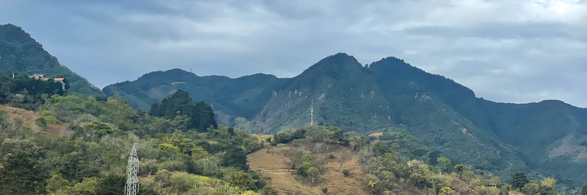
Introduction
Climbing at Pico Blanco is one hell of an adventure. Including the fact that it is best to stay for the night, one could say that it has the feel of a mini expedition climb. All factors combined, this is the most extreme location of all mentioned in this guide. Not only is getting to the top of the wall a challenge, with the lowest grade being 5.11c, but getting to the base of the wall is also a challenge with solid class 4 trekking constantly uphill through venomous snake inhabited forests with no or little trail to follow. Moreover, the weather and amount of time it takes to get there makes Pico Blanco suitable for only the fit, strong-willed, adventure seeker.
The Wall
There are multiple walls on a single large feature of rock called El Torre (The Tower), which is visible and aesthetically magnificent from a good portion of the latter bit of the approach. El Torre jets up out of the hillside and provides a view of San José as an incredible backdrop while climbing. Because of the high altitude, cool temperatures, and amount of mist, lichen has coloured much of the wall in bright oranges, yellows, and greens.
There are various features such as a large slab section, an arête, and straight vertical wall. Also a large ledge provides a second belay for multi-pitch climbing. There is great potential for expansion on this rock, as the wall around the 6 routes that have been bolted is vacant.
The Rock
The metamorphic rock provides visually pleasing arrays of colours, and a physically enjoyable selection of pockets, ledges, and crimps. The rock can be a bit chossy due to the constant heating and cooling from the changing weather. I would highly recommend a helmet.
Eating
Bring all food and water as the closest source of either is a 2 hour hike into San Antonio. Many locals drink from the nearby river regularly without problems. If you are bringing food in, please ensure you take your garbage out.
The Weather
The elevation of Pico Blanco (2428m) can be both friend and enemy as weather can change quickly from sunny, windy, and cool, to cloudy, windy, and cold. In the heat of the Costa Rican summer, Pico can be a comforting place to climb thanks to the much cooler temperatures (sometimes 10°Cdifference or more) found in the mountains in comparison to the valley and city. However the weather can also wreck havoc on your climbing plans. If the cloud ceiling is particularly low, expect the weather on Pico Blanco to be wet, cold, and windy, even if it is hot and sunny in the city. For this reason, it is always good to not only check the weather forecast before you leave to climb, but also to look up at Pico Blanco and determine if clouds are engulfing the peak.
Routes
Pico Blanco hosts a great potential for more than the 6 routes that are currently found on a single section of the mountain. With many other rock faces around the summit of Pico Blano, it would not be a suprise if future developments were targeted for this area. All of the routes here are at the harder end of the spectrum and have incredible exposure, with views of San José and the surrounding valley, giving Pico Blanco the feeling of being more like a big wall climb that single pitch sport climbs. Routes are listed counter clockwise starting with El Trepon de la Zeguea.
Approach
By Car
Approximate time: 20 minutes
Take highway 27 from the South Sabana west out of San José. You will go under a bridge with a green mural of a butterfly, frog, and train painted on it and then over a large ravine. Take the first exit off the highway after the ravine. There is an EPAon the right and this road will take you down and around to the left under the highway heading southbound. Directly after going under the highway, there will be a Walmart on the right hand side and then a set of lights.
Continue straight through the set of lights past a T.G.I.F. restaurant. Maintain on this road, keeping to the left at the gas station. This will take you into central Escazu. You will be forced to take a right (due to the one way streets) and then at Calle 1 make a left. Go south on Calle 1 for approximately 1km, then make a left onto Avenida 8 (this is directly after the Colegio Nuestra Senora del Pillar). Go to the end of the street and make a right onto Calle 5. Take Calle 5 south for about 1.5km into the town of San Antonio de Escazu. Immediately after the large yellow church with red trim in the center of San Antonio de Escazu, make a right, pass the side of the church, the soccer field, cross a small bridge, and then keep to the left at the merging streets. Follow this road south past the Cementerio San Antonio.
At anytime if you are lost or unsure of your bearings, ask for directions to Cementerio San Antonio. Continue south, passing The White House hotel and casino on the left and keeping to the right at Parliament Hill. Another 750m after Parliament Hill the paved road will end. If you think your vehicle can handle light off-roading, continue to the top of the hill, and make a right in the opposite direction of the house with the high cement wall. Follow the dirt road, which will return to being paved for a short hill. At the top of the hill make a right and park along the trailhead, continuing the remainder of the approach on foot.
By Bus
Approximate time: 30 minutes
From San José take the blue San Antonio de Escazu bus from the Coca Cola area. The bus picks up from multiple stops around the Coca Cola, so the best thing to do is to ask where the closest stop is relative to your current location. Get off the bus in San Antonio de Escazu. There is a yellow church with red trim that has a bleak looking rose garden and twin clock towers. There is also a soccer pitch directly in front of the main entrance of the church. After dismounting from the bus it is ‘choose your own adventure’ time. You can: (A) take a 1.5 hour hike up the streets of Escazu until you reach the trailhead, and then hike another 1.5 hours to the rock face. Alternatively, (B) you can take a taxi as far as it will take you and then hike the rest. How far the taxi can take you will depend on if your taxi is four-wheel drive, or if your driver thinks his compact can handle the rough roads. Either way, ask your driver to take you to the White House (La Casa Blanca) Hotel/Casino/Restaurant. From this easily identifiable landmark (via taxi or heel-toe express) continue up the hill, choosing either the right or left of the building marked “Parliament Hill.” If you stay to the right (the shorter route), the paved road will end with a heavily fortified (a retaining wall, electric fence and security cameras) house on the left. Make your way to the top of the fortified house’s property where the road splits to the left and to the right. Make a right turn and continue on the unpaved road for approximately 500 meters until the road becomes paved again and bends up a hill to the left.
If you stay to the left of “Parliament Hill” the road remains paved until you hit the dirt raod at the top of the hill next to the heavily fortified house. If your vehicle is not ‘hearty’ I would recommend the longer but paved left route. Continue on the unpaved road.
Along the way you will be able to see rock formations above you on the mountain, but this is not where you will be climbing – although future development may open up this side of the mountain to climbing as well. The rock you are going to faces the opposite way, overlooking San José.
After approximately 200 meters the paved hill will summit with a slight turn to the right. At the top of the hill the road will continue to the left, and there on your right will be the main trailhead (which is actually a dirt road for the first 150 meters, but thereafter thins out into a rocky trail only accessible by ATV, horse, dirtbike, mountain bike and foot). Begin the approach on foot or ATV, dirtbike, mountain bike, horse, if available.
Approach
Approximate time: 1.5 hours
From the trailhead, walk away from the paved road passing the ‘container’ house on the left, followed by a chain-linked fence that is blocking a driveway leading down to a property. The trail will continue for approximately 10 minutes, until you begin walking parallel to a river. At one point the trail will move closer to the river so that there is direct access to the river. Just after this you will see a potrero on the right hand side. Apotrero is a Spanish word that means an area of land that has been cleared for cattle grazing. In this case, this potrero is on the side of Pico Blanco and is surrounded by a barbed wire fence. You will notice many large boulders and trees across the uphill potrero, however for the most part, the land is clear and there is grass. Climb over the fence and enter the portero, being mindful of snakes when crossing the land. As you hike the hill you will be able to see El Torre directly in front of you. Work your way up and to the left, until you reach a pine forest, which is bordered by another barbed wire fence indicating the end of the potrero land. Climb over this fence and continue up the center of the pine forest for approximately 10 minutes. Where the pine forest ends and the tropical forest begins, slightly to the right, there is a small, easy to miss trail that goes up between two partially ground embedded boulders. If you have a machete and have not been using it, now would be a good time to dawn this tool. Follow the thin trail through athe tropical forest for about 7 minutes until you reach the wall. Be careful for loose soil as the hiking is steep at some places. Use the surrounding trees to stabilize yourself being mindful of loose or uprooted vegetation that will not hold your bodyweight should you slip. For this part of the trek, bring a walking stick to help ground yourself. The first climbs are directly to the left as you reach the wall.
Where to stay
Pico Blanco can be climbed in a day, but it is a long day – up early, back late. If you do not wish to get caught in the dark or do not fancy a sunrise wake-up, a less rushed option is to camp and stay overnight, allowing for more time to work the wicked crux on Julieta-ta. The best place to camp is within the pine forest at the base of the rock. There are multiple flat areas where pitching a tent is feasible, and to go to the crag is only a 5 minute walk.
Ethic
- Respect the land owners.
- They are kind enough to let you use their property for your enjoyment.
- Respect other climbers.
- Climbing is a community sport where the only opponent is the cruel crux that sends you airborne.
- Respect the environment.
- Above all, respect the environment. The plants, the earth and the rock itself were here long before you came into existence and will continue to exist long after you are gone. Sustain its survival by treating it properly.
Pick up trash, even if it is not your own. Take at least one piece out on every trip.
Do not kill flora or fauna, no matter how small or large.
Live and climb as though you are organic with your environment.
Plan your Trip
Did you know?
Did you know that you can create an account to record, track and share your climbing ascents? Thousands of climbers are already doing this.


Thu 25 May
Check out what is happening in Pico Blanco.
Get a detailed insight with a timeline showing
- Ticks by climbers like you
- Discussions of the community
- Updates to the index by our users
- and many more things.
Login to see the timeline!