Use this Region Guide to easily find and compare Crags.
Table of contents
- 1.
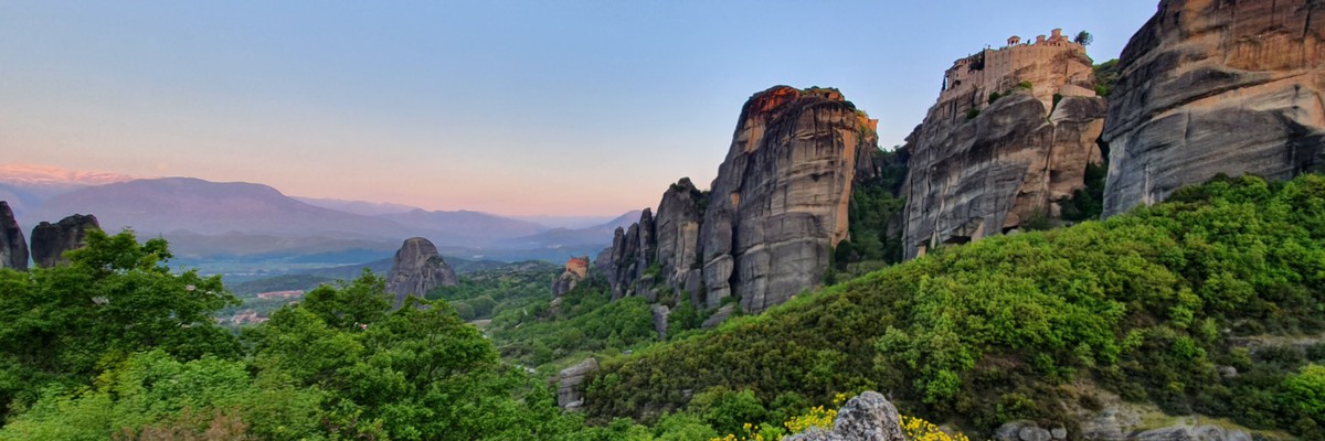
Greece / Ελλάδα
18868 in Region
-
1.1.
Aegean Islands 6527 in Region
- 1.1.1. Amorgos 10 in Crag
- 1.1.2. Anafi 8 in Area
- 1.1.3. Chios 22 in Crag
- 1.1.4. Ikaria 85 in Area
- 1.1.5. Kalymnos 4391 in Crag
- 1.1.6. Karpathos 398 in Area
- 1.1.7. Kos 326 in Area
- 1.1.8. Leros 35 in Crag
- 1.1.9. Lesbos 27 in Area
- 1.1.10. Rhodes / Rhodos / Ρόδος / Ródos 151 in Area
- 1.1.11. Samos 67 in Area
- 1.1.12. Santorini 133 in Crag
- 1.1.13. Schoinousa 32 in Area
- 1.1.14. Skyros 13 in Area
- 1.1.15. Symi / Simi / Σύμη 25 in Crag
- 1.1.16. Tinos 804 in Crag
-
1.2.
Athens / Attica 1771 in Region
- 1.2.1. Parnitha / Πάρνηθα 678 in Area
- 1.2.2. Penteli / Πεντέλη 192 in Area
- 1.2.3. Ymittos / Υμηττός 356 in Area
- 1.2.4. Aetofolia / Αετοφωλιά 51 in Crag
- 1.2.5. Agia Marina 11 in Crag
- 1.2.6. Chaos Lavrio / Χάος Λαύριο 30 in Crag
- 1.2.7. Daskaleio / Δασκαλειό 38 in Crag
- 1.2.8. Etos / Έτος 17 in Crag
- 1.2.9. Filopapou 32 in Crag
- 1.2.10. Iera Odos / Latsoudorema / Poikilo Oros 77 in Crag
- 1.2.11. Kakia Thalassa 29 in Crag
- 1.2.12. Keratsini / Kokkinovrachos 55 in Crag
- 1.2.13. Zacharitsa / Ζαχαρίτσα 14 in Crag
- 1.2.14. Koutsomarakis / Κουτσομαράκης 7 in Crag
- 1.2.15. Mavrosouvala 47 in Crag
- 1.2.16. Merenda / Markopoulo 47 in Area
- 1.2.17. Magoula 11 in Crag
- 1.2.18. Pateras - Rachi Ntoskouri / Ράχη Ντόσκουρη - Μέγαρα 3 in Area
- 1.2.19. Pateras - Kandyli 8 in Crag
- 1.2.20. Tourkovounia 52 in Crag
- 1.2.21. Varkiza 0 in Crag
- 1.2.22. INDOOR, EOS Acharnon 14 in Gym
- 1.2.23. INDOOR, EPOS Fylis 0 in Gym
- 1.2.24. INDOOR, The Wall 0 in Gym
- 1.2.25. INDOOR, OAKA Indoor Climbing 2 in Gym
- 1.2.26. INDOOR, Rockway 0 in Gym
- 1.2.27. INDOOR, Workout Hall 0 in Gym
- 1.2.28. INDOOR Redpoint Athens Climbing Center 0 in Gym
- 1.2.29. OUTDOOR & INDOOR Project Mono 0 in Gym
- 1.3. Crete / Kreta / Κρήτη 1392 in Region
-
1.4.
Evia 772 in Region
- 1.4.1. Dokos / Σπηλιά Παπαγιάννη / Δοκός 26 in Crag
- 1.4.2. Kamari, Evia 67 in Crag
- 1.4.3. Kampia - Kotroni / Καμπιά - Κοτρώνι 61 in Area
- 1.4.4. Kasteli / Καστέλι 16 in Crag
- 1.4.5. Kymi 570 in Region
- 1.4.6. Limni 10 in Crag
- 1.4.7. Paralia Damianos / Xiliadoy 2 in Boulder
- 1.4.8. Steni - Karaouli 18 in Crag
- 1.4.9. Xerovouni 2 in Region
-
1.5.
Ipeiros 762 in Region
- 1.5.1. Pades 45 in Area
- 1.5.2. Konitsa 70 in Area
- 1.5.3. Loutra Amarantou 2 in Area
- 1.5.4. Kleidonia 21 in Crag
- 1.5.5. Kipoi 39 in Crag
- 1.5.6. Vikos Gorge 57 in Area
- 1.5.7. Garnarosia (perivleptos) 32 in Crag
- 1.5.8. Krya area 32 in Area
- 1.5.9. Veranda 11 in Crag
- 1.5.10. Kastritsa 125 in Area
- 1.5.11. Frontzo 14 in Crag
- 1.5.12. Meliggoi 19 in Crag
- 1.5.13. Pesta 9 in Crag
- 1.5.14. Emin Aga Cave 26 in Crag
- 1.5.15. Terovo-Zita 18 in Area
- 1.5.16. Petra / Anatoliko Zagori 45 in Crag
- 1.5.17. Paliochori 105 in Area
- 1.5.18. Tsouma 3 in Field
- 1.5.19. Tzoumerka / Τζουμέρκα 13 in Area
- 1.5.20. Karteri 27 in Area
- 1.5.21. Zaloggo 49 in Area
-
1.6.
Central Greece 608 in Region
- 1.6.1. Aitoloakarnania 235 in Region
- 1.6.2. Viotia 51 in Region
- 1.6.3. Topoliana / Τοπόλιανα / Δυτικά Άγραφα 124 in Area
- 1.6.4. Parnassos 95 in Region
- 1.6.5. Portes 75 in Crag
- 1.6.6. Kouvelos 5 in Area
- 1.6.7. Ypati / Λευκός Κρίνος / Lefkos Krinos 11 in Crag
- 1.6.8. Gkiona 11 in Area
- 1.6.9. Koziakas 1 in Area
-
1.7.
Macedonia 1163 in Region
- 1.7.1. Thessaloniki / Θεσσαλονίκη 204 in Area
- 1.7.2. 3-5 pigadia 107 in Sector
- 1.7.3. Aliakmonas / Nikos Pitoulias / ΝΙΚΟΣ ΠΙΤΟΥΛΙΑΣ 29 in Crag
- 1.7.4. Pinovo 132 in Crag
- 1.7.5. Serres 129 in Region
- 1.7.6. Sidirokastro 22 in Area
- 1.7.7. Petropigi (Ble Zina) 47 in Crag
- 1.7.8. Kranochori 29 in Crag
- 1.7.9. Loutraki 10 in Sector
- 1.7.10. Nea Iraklitsa / Νέα Ηρακλείτσα 174 in Area
- 1.7.11. XIROPOTAMOS 24 in Area
- 1.7.12. KEFALARI 20 in Area
- 1.7.13. Falakro mountain 21 in Area
- 1.7.14. Krasta 4 in Area
- 1.7.15. Nea Zoi 39 in Area
- 1.7.16. Paliouri 7 in Area
- 1.7.17. Tsouriakas 20 in Area
- 1.7.18. Mpourinos 2 in Area
- 1.7.19. Rodiani 1 in Area
- 1.7.20. Mpara - Siatista 4 in Area
- 1.7.21. Koromilia - Kastoria 1 in Area
- 1.7.22. Palaiokastro - Mpourinos 7 in Area
- 1.7.23. Olympus / Όλυμπος 55 in Area
- 1.7.24. Ai-Lias Kozani 23 in Region
- 1.7.25. Spileo Grevena 15 in Area
- 1.7.26. Kozani 13 in Region
- 1.7.27. Florina 24 in Area
- 1.8. Peloponnese 4260 in Region
-
1.9.
Thessaly 1218 in Region
- 1.9.1. Upper Pinios Valley 350 in Area
- 1.9.2. Magnesia / Μαγνησία 574 in Area
- 1.9.3. Mouzaki 84 in Crag
- 1.9.4. Pyli Trikala 113 in Region
- 1.9.5. Tempi 88 in Area
- 1.9.6. Petroporos 1 in Crag
- 1.9.7. Gyntiki / gidiki 8 in Crag
-
1.10.
Thrace 371 in Region
- 1.10.1. Avantas / Avas 61 in Area
- 1.10.2. Maronia 103 in Sector
- 1.10.3. Nestos 137 in Area
- 1.10.4. Strimi 43 in Crag
- 1.10.5. Samothraki 0 in Region
- 1.10.6. Symvola Gorge 20 in Area
- 1.10.7. Fairy Tale Quarry 7 in Crag
-
1.11.
Ionian Islands 24 in Region
- 1.11.1. Zakynthos / Zakinthos / Ζάκυνθος 0 in Area
- 1.11.2. Atokos / Άτοκος 0 in Crag
- 1.11.3. Corfu 24 in Area
-
1.1.
Aegean Islands 6527 in Region
1. Greece 18,868 routes in Region
- Summary:
-
Mostly Sport climbing
Lat / Long: 38.044128, 24.554689
description
some overview of climbing areas at http://climbgreece.com
1.1. Aegean Islands 6,527 routes in Region
- Summary:
-
Mostly Sport climbing
Lat / Long: 37.270270, 26.180270
1.1.1. Amorgos 10 routes in Crag
- Summary:
-
All Sport climbing
Lat / Long: 36.849687, 25.899229
1.1.2. Anafi 8 routes in Area
- Summary:
-
Bouldering, Trad climbing and Sport climbing
Lat / Long: 36.364698, 25.795157
1.1.3. Chios 22 routes in Crag
- Summary:
-
Mostly Sport climbing
Lat / Long: 38.410817, 26.034905
summary
Island North East of Greece
1.1.4. Ikaria 85 routes in Area
- Summary:
-
All Sport climbing
Lat / Long: 37.596412, 26.153154
description
Bouldering guidebook https://shop.vertical-life.info/en/ikaria-bouldering-guidebook
1.1.5. Kalymnos 4,391 routes in Crag
- Summary:
-
Mostly Sport climbing
Lat / Long: 36.987998, 26.968021
Laws introduced in 2015 require that you must have a license for a scooter/motorbike. Depending on your home country, you may need an international driver's license.
If you hire a scooter: take it easy. Tonnes of people come off. The sharp turn at Kasteli is especially dangerous.
Typically, a scooter costs 12-15 € per day. Some shops offer 125 cc/150 cc scooters for around 20 € per day. Hiring for less than 3 days makes it more expensive.
- PREPARE to leave nothing behind (trashbag, etc).
- Use your own gear for toproping. Use fixed gear only for lowering. (See first section of guidebook for details.)
- Minimize single-use plastic. No recycling on the island (yet).
- Use established paths and close gates behind you.
- Consider a donation to the rescue team (red boxes).
summary
Probably the world's most popular destination for combining sport climbing and island vacation.
description
Climbing on best quality limestone of all angles. The vertical and overhanging walls are full of typical, Kalymnian flowstone and stalactite holds.
Kalymnos is popular for its great local food and the international scene travelling here. Small, family-owned appartments (most popular with climbers) or mid-sized hotels are very close to the climbing sectors, the beaches, restaurants, climbing shops and everything else you're here for. That is what makes Kalymnos great for most – climbing, beach, great food, easy logistics.
approach
For info on how to get to Kalymnos, for recent ferry timetables, etc, visit climbkalymnos.com.
Getting around the island
By Foot — Depending on where you stay, the approach paths to some of the best crags of the island are just a short walk away.
Bicycle — Also a valid option if you want to save money, be eco-friendly, or wanna get ripped. A good choice for getting around in Masouri or to get to Odyssey, Kasteli and surrounding crags. Typically, 5 € per day.
Scooter — The most popular choice on Kalymnos.
where to stay
The villages Mirties, Masouri and Armeos on Kaly's west coast are the most popular choices, as everything you're coming to Kalymnos for is within walking distance. There are also good options – anything from simple to luxurious - further south of Masouri (Kamari, Panormos bay) or spread around the rest of the island (below sector Odyssey, Kasteli bay, Arginonta bay, Emporios, ...).
ethic
history
Developed very recently, compared to most European climbing destinations. The first climbs where established by Andrea Di Bari and team in 1997 (sectors 'Arhi', 'Poets', ...). Di Bari discovered the island's potential one year prior. About 10 years later the route count surpassed 1,000. The 2023 edition of the Kalymnos Guidebook by Aris Theodoropoulos covers more than 4300 routes.
1.1.6. Karpathos 398 routes in Area
- Summary:
-
Mostly Sport climbing
Lat / Long: 35.628940, 27.168411
description
Karpathos is the 2nd largest and one of the most beautiful Dodecanese island in the Aegean Sea. It is well known for strong winds and windsurfing and has good touristic infrastructure. And it is perfect for climbing an is getting known as a 2nd Kalymnos. The rich mountainous terrain of Karpathos creates an impressive changing of landscapes, which enchants the visitor. In a short distance the landscape changes dramatically. Its rocky and green mountains always end up with a view of the deep blue and picturesque beaches of Karpathos. This is the main reason why Karpathos is considered the ideal island for hikers and climbers.
Website and guidebook: https://climbkarpathos.com
history
2005-2010 Franz Ehrnthaller and friends started bolting, see guidebook pdf. After 2015 a big polish crew started bolting at large scale.
1.1.7. Kos 326 routes in Area
- Summary:
-
All Bouldering
Lat / Long: 36.802668, 27.116309
1.1.8. Leros 35 routes in Crag
- Summary:
-
All Sport climbing
Lat / Long: 37.156093, 26.831197
1.1.9. Lesbos 27 routes in Area
- Summary:
-
All Sport climbing
Lat / Long: 39.181911, 26.269815
1.1.10. Rhodes 151 routes in Area
- Summary:
-
Mostly Sport climbing
Lat / Long: 36.186781, 27.915989
summary
Rhodes, the beautiful island of the sun, is the largest of the Dodecanese islands in the Aegean Sea. On average, Rhodes has 300 days of sunshine a year.
description
While between April and October the chances of uninterrupted sunshine are virtually 100%. The island well known as a top windsurfing and kitesurfing spot in Europe also offers rock climbing at several crags across the island.
The main sector of the island is Ladiko, located just after Faliraki a well known touristic place on the east side of Rodos. Nearby are also "Antony Quinn" and Afantou sectors. Very close to these sectors there is a magnificet beach - Traganou - where you can really enjoy bouldering next to the sea water. Further, south you can visit Gadoura a small but stunning sector. In the middle of the island there is sector Platania and on the west side remotely located, Siana sector. Finally nearby the famous Lindos bay and Acropolis of Lindos there is a great rock - future project - with very big possibilities. Rockclimbers are welcome to open new routes.
history
Rock climbing development started in the year 2000.
1.1.11. Samos 67 routes in Area
- Summary:
-
Mostly Sport climbing
Lat / Long: 37.728567, 26.820023
1.1.12. Santorini 133 routes in Crag
- Summary:
-
Mostly Sport climbing
Lat / Long: 36.405173, 25.403875
description
Santorini is the idyllic Greek island with the pretty white buildings you see on post cards. Most people show up here to lounge on the beaches (available in several colors), drink cocktails, and stay up all night bar crawling/clubbing. If you can sneak away in the mornings while the rest of your group is sleeping (and your head isn't ringing too badly) then you can find a good deal of climbable rock on the east side of the island. Best if there's at least one functional belayer you can drag along. You'll probably be here in the summer and it does get hot, so get an early start and don't forget some water! The sectors can be reached from the towns of Kamari or Perissa.
This is a bit of a different sport climbing destination, there are only about 120 routes here at the moment but you also need to factor in the great weather, intriguing history, fantastic rock formations. Add to these an interesting set of well bolted routes across the grades, which are close a swim in the sea and there is some fine Greek cooking too.
Santorini is the most southerly of the islands that make up the Cyclades chain. It is only a small island but it packs a lot of interest in with its amazing geology, holiday resorts and sunsets. The explosion that destroyed the volcano that once made up the island (and put an end to the Minoan civilisation) at around 2500BC was one of the biggest cataclysms of all time, the crater that remains is four times the size of that at Krakatoa. Fortunately the rock isn't all volcanic rubble, the mountains that make up the southern end of the island are limestone, and here a couple of climbing venues have been developed.
With some shade on offer is possible to climb all year round but the best times are spring and autumn. Winter is also a possibility although things are much quieter than during the main tourist season. It is possible to climb during the hotter summer months but hot afternoons are better spent on the beach or taking a siesta.
approach
Plane or ship from Athens. Popular tourist destination but don't expect to find many or any other climbers.
history
In the autumn of 2008, a large project of opening climbing routes in Santorini was carried out, which was financed by a program of the European Union. Andreas Koutroubis undertook the planning and implementation responsibility. Around 120 routes were opened in the seven fields of the island, some of which are multi-rope in the area of Perissa.
The routes were opened by Yannis Toreli, Thomas Michaelidis, Vassilis Mitsios, George Koutsoukis, Nikos Hatzis, Vangelis Kastanias, George Aliferis and Aris Theodoropoulos. The ratings of most routes were given by Giannis Torelis and Thomas Michaelidis from a first ascent so there may be small discrepancies.
1.1.13. Schoinousa 32 routes in Area
- Summary:
-
Mostly Sport climbing
Lat / Long: 36.866518, 25.513027
summary
Schinoussa is a rising rock climbing destination, attracting devoted fans every year. The gorge of Charaka is a climbing field of exceptional quality.
description
The spot is near the sea and it has breathtaking view and natural beauty. The climbing centre consists of more than 40 routes with dificulty level reaching up to 7c.
access issues
There no serious issues approaching the crag.
approach
You have to follow the road to Tsigouri beach and as soon as you reach Grispos Appartments turn right and follow a 5-10 min path to the crag
where to stay
You can stay only in rentals. Free camping is not allowed.
history
Initiator of the project was the French mountain guide Cristophe Moulin by the financial aid of Schinoussa’s Community and Greek volunteers like George Klαoudatos, Giannis Konstantakis, Alexis Grapsas
1.1.14. Skyros 13 routes in Area
- Summary:
-
All Sport climbing
Lat / Long: 38.873654, 24.549509
summary
1.1.15. Symi 25 routes in Crag
- Summary:
-
All Sport climbing
Lat / Long: 36.583621, 27.825131
summary
A small island between Rhodes and the Turkish mainland, just south of Datça.
approach
You can reach Symi either from Piraeus, from Rhodes, from Kos or Kalymnos in Greece or from Datça in Turkey.
1.1.16. Tinos 804 routes in Crag
- Summary:
-
Mostly Bouldering
Lat / Long: 37.599166, 25.115842
description
Tinos is a Greek island situated in the Aegean Sea. It is located in the Cyclades archipelago. The closest islands are Andros, Delos, and Mykonos. Tinos is famous amongst Greeks for the Church of Panagia Evangelistria and its 80 or so windmills. There is a lot of potential for outdoor activities as hiking, climbing and bouldering. The rock texture of the island rock is granite something unusual for Greek rock. A big thank you to Samuel Bardy & Julie Stentz that gave us most of the 2022 updates.
approach
As Tinos has no airport the only way to get to the island is by ship. Tinos has three ports, one for passenger speed boats, and two for ferries and highspeed boats which carry passengers and cars to other ports, including Mykonos (35 min), Piraeus, Rafina, Andros and Syros.
1.2. Athens 1,771 routes in Region
- Summary:
-
Mostly Sport climbing
Lat / Long: 37.989674, 23.603477
summary
The Capital of Greece with dozens of crags nearby, most easily accesible
description
Athens is a big city and in terms of climbing Atheneans are very lucky. There are nearby routes from 3 to 8th grade, short, long, sport, trad and mixed. Different crags may have complete different characteristics.
Climbing in Athens is friendly all year round if you choose the correct crag according to sun position
In general, if you travel by car approach is not an issue, most crags require less than 15 minute walking.
approach
Nearest airport is Eleftherios Venizelos (ATH). Biggest nearby ports are Piraeus, Rafina and Lavrio There is train (OSE) and bus (KTEL) conection with all major cities of Greece daily.
where to stay
Athens is full of Hotels, hostels, AirBnBs so you won't have problem finding where to stay
1.2.1. Parnitha 678 routes in Area
- Summary:
-
Mostly Sport climbing
Lat / Long: 38.162908, 23.712997
description
One of the three main mountains of athens, hosting several crags.
1.2.2. Penteli 192 routes in Area
- Summary:
-
Sport climbing, Trad climbing and other styles
Lat / Long: 38.080217, 23.894786
description
One of the three main mountains of Athens, hosting several crags
1.2.3. Ymittos 356 routes in Area
- Summary:
-
Mostly Sport climbing
Lat / Long: 37.909748, 23.799696
summary
One of the three main mountains of Athens, that hosts several crags.
1.2.4. Aetofolia 51 routes in Crag
- Summary:
-
All Sport climbing
Lat / Long: 38.092434, 23.328459
access issues
The dirt road that reaches right next to the crag, at some point seems to be part of a brook, so may be inaccessible during or after heavy rains, at least without an offroad vehicle.
approach
1.2.5. Agia Marina 11 routes in Crag
- Summary:
-
All Sport climbing
Lat / Long: 37.821058, 23.831539
summary
Small interesting crag close to the sea
1.2.6. Chaos Lavrio 30 routes in Crag
- Summary:
-
All Sport climbing
Lat / Long: 37.720861, 24.021359
summary
at summer shadow after 13.00
description
80 meter robe is necessary
1.2.7. Daskaleio 38 routes in Crag
- Summary:
-
All Sport climbing
Lat / Long: 37.831372, 24.058279
summary
An impressive by the sea crag with beautiful rock and lots of mid range difficulties. Some routes are bolted with dangerous bolts and need to be maintained!!!
description
A close to the sea climbing crag with beautiful view,face climbing,dihedrals and a long chimney.
access issues
From Keratea, follow the road to Kakia Thalassa and Daskaleio. At the crossroad before Kakia Thalassa, follow the right road towards Daskaleio. Turn left at Katerinis str and then right at Anemon str. Head to the semi constructed building at the top of the hill and park there.
approach
Follow south the downhill path (not wellsigned)for 5-10mins to reach the foot of the crag.
ethic
Avoid bolting on the stalactite area of the cliff for conservation reasons.
1.2.8. Etos 17 routes in Crag
- Summary:
-
All Sport climbing
Lat / Long: 38.001897, 23.957656
description
more info: http://www.vrahomania.gr/etos_spaton/
approach
Accessible from Vatopediou street (dirt road, SW of the cliff). Park the car here : https://goo.gl/maps/8uDz77VDrDz
1.2.9. Filopapou 32 routes in Crag
- Summary:
-
Mostly Sport climbing
Lat / Long: 37.965434, 23.717511
description
Climbers should feel comfortable cleaning the anchors. Some might find leading a bit intimidating, since the first bolt is often placed quite high. Somewhat slippery rock.
A 60m rope and a dozen draws should suffice.
approach
Usually easy to park your car outside the Dora Stratou Theater (Arakinthou street). Nearest Subway Stations, Sygrou/Fix (line 2 - red line and TRAM) and Petralona (line 1 - ISAP) Nearest Bus Stop, Filopappou (Trolleybus 15)
1.2.10. Iera Odos 77 routes in Crag
- Summary:
-
Mostly Sport climbing
Lat / Long: 38.033393, 23.642797
summary
Maybe the best winter crag of Athens, with grades from 4 to 8
access issues
The path from Petroupoli, is exposed towards its end. Fixed ropes and rungs have been placed to assist descending. Be careful not to throw any rocks, as the path traverses right above the climbing routes!
If accessing from Aigaleo ring road, note that car brake-ins have been reported.
approach
# From Petroupoli
From Agias Triados at Petroupoli, continue straight uphill, bypass Petroupolis Municipal Athletic center, and follow the unpaved road. At the first intersection, continue straight, at the second, turn right, at the third turn left and immediately after, at the fourth intersection, turn right. Follow the cairns (South). This path ends between sectors Archí and Ekpaideftikés.
# From Aigaleo Ring Road
Through Aigaleo Ring road you can approach Agias Foteinis street, pass under the Aigaleo Ringo Road via Evrou street and take a right turn. Follow the dirt road uphill to left side of the bridge, and follow the path after crossing the train rails right before the tunnel.
(note that both paths are visible if you switch to OSM map)
1.2.11. Kakia Thalassa 29 routes in Crag
- Summary:
-
Mostly Sport climbing
Lat / Long: 37.832779, 24.047029
1.2.12. Keratsini 55 routes in Crag
- Summary:
-
All Sport climbing
Lat / Long: 37.978504, 23.619314
summary
An old abandoned but recently renewed crag.
description
The North East part of the crag is in the sun in the morning, the NorthWest in the afternoon.
access issues
The junkyard owners are not very fond of passing through with your car. Leave it before the junkyard and pass through it on foot.
approach
Either leave your car before the junkyard and walk through it, or leave your car at the end of othonos street and traverse the hill above the junkyard.
1.2.13. Zacharitsa 14 routes in Crag
- Summary:
-
All Sport climbing
Lat / Long: 38.063845, 23.695696
summary
Zacharitsa
description
Small but sweet crag with convenient access! Do not underestimate routes, they feel stiff for their grades.
approach
Park at the end of "Agamemnonos" street (38°03'53.2"N 23°41'45.4"E). Facing the hill & crag walk left and then turn right after passing the fence.
history
Set by Tsitsikas and Valaziotis in end of 2023.
1.2.14. Koutsomarakis 7 routes in Crag
- Summary:
-
Mostly Sport climbing
Lat / Long: 38.057834, 23.687343
approach
Path starts from an unnamed road, 2 roads parallel west of Agiou Nikolaou, and Chelmou str.
Find nice parking place at the end of Agiou Nikolaou where there is an enterprise open in working hours.
history
1.2.15. Mavrosouvala 47 routes in Crag
- Summary:
-
All Sport climbing
Lat / Long: 38.251657, 23.805799
summary
An impressive 50m tall cave in an otherwise rock-barren area with excellent rock quality. Being so close to Athens it can be considered the "outdoor gym" for the local hard-movers.
description
Many of the routes have quickdraws on.
approach
From Athens drive on the Athens - Lamia - Thessaloniki highway (A1 / E75) to the exit of Markopoulo (about mile marker 35km). Follow the road in direction of Markopoulo. After about 3km take a left and then take a right towards the village of Mavrosouvala. Take a left just before the village (industrial facilities). Parking at ( 38.251742, 23.805340). Hike up the steep trail.
history
Discovered in January 2006 and inaugurated in May 2006 by the Acharnes Alpine Club.
1.2.16. Merenda 47 routes in Area
- Summary:
-
Mostly Sport climbing
Lat / Long: 37.853886, 23.992985
where to stay
The area is near Markopoulo.
1.2.17. Magoula 11 routes in Crag
- Summary:
-
All Sport climbing
Lat / Long: 38.156686, 23.502149
1.2.18. Pateras - Rachi Ntoskouri 3 routes in Area
- Summary:
-
All Trad climbing
Lat / Long: 38.045196, 23.368144
summary
A new trad crag from Kostas Hortis.
description
All the infos for the routes are here : https://www.routes.gr/Community/viewtopic.php?f=12&t=2817&p=10397&hilit=%CF%81%CE%AC%CF%87%CE%B7+%CE%BD%CF%84%CE%BF%CF%83%CE%BA%CE%BF%CF%85%CF%81%CE%B7#p10397
approach
Park near the gate of quarry ΣΤΑΜΕΛΟΥ (38°02'25.4"N 23°21'48.4"E). Walk around from the left side.
1.2.19. Pateras - Kandyli 8 routes in Crag
- Summary:
-
All Trad climbing
Lat / Long: 38.054251, 23.409267
summary
Adventure climbing close to Athens
description
A crag area for trad near to Athens.
approach
Near to Megara - 30' from Athens.
where to stay
Athens.
1.2.20. Tourkovounia 52 routes in Crag
- Summary:
-
Mostly Sport climbing
Lat / Long: 38.006392, 23.756889
summary
An old crag with short lines left on its own fate
description
down town Athens climbing, but the place is far from inspiring
approach
5 mins
1.2.21. Varkiza 0 routes in Crag
summary
Deep Water Solo, near organized beaches with water sports, cafes etc. Good rock quality, easy access and many facilities in the area make this a great spot for the summer!
description
Right after the beach of Varkiza is the water solo area. There is a traverse of about 200 meters long that ranges in height from about 4 to about 8 meters high. Rocks for single routes and short traverses continue further down the coast. Water is deep enough and clear. The area is under the sun all day, apart from very early in the morning.
access issues
There are no issues affecting access.
approach
The area is located right after the coastal suburb of Varkiza. It is 22 kilometers from the center of Athens, on the Poseidonos Avenue (EO91) that goes to Sounion. There are frequent buses to Varkiza There is a Parking area at both ends of the traverse with no walking time.
1.2.22. INDOOR, EOS Acharnon 14 routes in Gym
- Summary:
-
Sport climbing and Top roping
Lat / Long: 38.071181, 23.738740
description
more info at http://www.eosacharnon.gr/anarihisi.html
1.2.23. INDOOR, EPOS Fylis 0 routes in Gym
Suburban railway: (Ano Liosia Station)
Buses: Β12, 713, 723 (bus stop Gefira Attikis Odou)
summary
description
126 squared meters of climbing surface, with a maximum 11 m height, hosting multiple boulder, top rope and lead routes.
Routes renewed every month
approach
Accessible via :
history
Built in 2019 by Walltopia
1.2.24. INDOOR, The Wall 0 routes in Gym
1.2.25. INDOOR, OAKA Indoor Climbing 2 routes in Gym
- Summary:
-
All Sport climbing
Lat / Long: 38.038986, 23.782281
description
approach
Metro station Eirini
1.2.26. INDOOR, Rockway 0 routes in Gym
description
more info at http://www.rockwayclimbing.com/
1.2.27. INDOOR, Workout Hall 0 routes in Gym
1.2.28. INDOOR Redpoint Athens Climbing Center 0 routes in Gym
summary
The only gym in the center and the municipality of Athens. Covers many climbing levels and offers different angles and styles of climbing, including a 5 meter roof that continues to an overhang.
description
1.2.29. OUTDOOR & INDOOR Project Mono 0 routes in Gym
summary
A new gym with a big outdoor wall 18 meter, speed wall and also indoodr boulder. For more info here https://monoclimb.gr/
description
Lead wall 725 m2 - 18 meter, Boulder 320 m2, Speed wall 120 m2, Tension Board
approach
Very close to metro station and bus stasion. Behind McDonald's.
1.3. Crete 1,392 routes in Region
- Summary:
-
Sport climbing, Trad climbing and other styles
Lat / Long: 35.316465, 24.914670
summary
Crete is the largest Greek islands and offers plenty of rock and sea. From a climbing perspective it is not as developed as some other islands but has huge potential.
description
Limestone as far as the eye can see! Crete is just waiting to be truly discovered. There are already hundreds of routes up all over the island with hundreds if not thousands waiting to be put up.
GUIDEBOOKS
Unfortunately there is no complete guidebook, but the following 5 local, partly outdated guidebooks. So let's make thecrag the complete guidebook! ;-)

 "Greece - Sport Climbing: The Best Of", Aris Theodoropoulos, 2nd edition 2017, ISBN 9789609456210. 30 sort crags in whole Greece, in Crete the 3 crags Voulismeno Aloni, Plakias and Thersanas are covered.
 [GR] "Crete - Climbing in Chania", ΜΑΝΩΛΙΣ ΜΕΣΑΡΧΑΚΗΣ, 2007, ISBN 9789608195950. Mostly in greek with a few english comments and approach descriptions, though with the topos usable for non-greek readers. It covers the areas Stavros, Kalathos, Monte Vardia, Aghii Apostoli, Theriso, Gigilos-Pyrgi and Marmara.

 "Climbing in Crete - From North to South", Phillipe Bugada, 2009, ISBN 9782952637817. Bilingual guidebook covering the north coast crags Skoteino and Malia and the south coast crags Plakias, Agiofarango, Kapetanania and Treis Ekklisies.

 [GR] "Crete - Kapetaniana", Phillippe Bugada, 2006, ISBN 9782952637800. Very colourful french guidebook in 4 languages for the
Kapetaniana crags.
[GR] "Crete - Kapetaniana", Phillippe Bugada, 2006, ISBN 9782952637800. Very colourful french guidebook in 4 languages for the
Kapetaniana crags.
"Kreta - Paradies Ostkreta", Albert Precht, 2015, self published. Poetic german guidebook covering 11 crags around the Ha-Canyon. Sportcrags and a lot of multipitch routes.
approach
The island is well served by ferries and can also be easily reached by plane. The easiest thing is to find your way to Athens and then get on a small plane or ferry to Heraklion. From there, you can rent a car or hop on a bus to most of the climbing areas. A car is recommended. Some climbing areas would be tough to get to without one.
1.3.1. Chania 394 routes in Area
- Summary:
-
Sport climbing, Bouldering and other styles
Lat / Long: 35.436832, 23.896374
description
[GR] "Crete - Climbing in Chania", ΜΑΝΩΛΙΣ ΜΕΣΑΡΧΑΚΗΣ, 2007, ISBN 9789608195950. Mostly in greek with a few english comments and approach descriptions, though with the topos usable for non-greek readers. It covers the areas Stavros, Kalathos, Monte Vardia, Aghii Apostoli, Theriso, Gigilos-Pyrgi and Marmara.
1.3.2. Rethymnon 233 routes in Area
- Summary:
-
Mostly Sport climbing
Lat / Long: 35.262400, 24.629025
1.3.3. Heraklion 573 routes in Area
- Summary:
-
Mostly Sport climbing
Lat / Long: 35.199939, 25.109286
1.3.4. Lassithi 192 routes in Area
- Summary:
-
Mostly Sport climbing
Lat / Long: 35.165327, 25.970340
summary
Eastern Crete is full of canyons with crags that no other area of Crete can compete with. There is huge potential for new developments.
approach
Take a ferry or fly into Heraklion and make your way east  .
.
where to stay
Contact Petr Fiala who is developing the area and has a house in Zakros where climbers are welcome to stay.
history
Development in this area started in 2016 by Petr Fiala and others.
1.4. Evia 772 routes in Region
- Summary:
-
Mostly Sport climbing
Lat / Long: 38.477359, 23.717770
summary
Evia offers among others Alpine and Sport routes near Athens
approach
Evia can be accesed by car from the Highway Athens - Thessaloniki. Also, there are numerous ferry connections. The most importants are from Rafina, Aidipsos and Glyfa
where to stay
Evia is a touristic place and there are lots of hotels and rooms as well as camping places
1.4.1. Dokos 26 routes in Crag
- Summary:
-
All Sport climbing
Lat / Long: 38.480596, 23.668403
summary
description
A very nice crag from EOS Chalkidas. Well bolted. Τhe down sector is good for beginners. No routes names or numbers on the rock.
approach
From Athens about 1,5 hour. From Chalkida 20 min.
where to stay
Chalkida.
1.4.2. Kamari, Evia 67 routes in Crag
- Summary:
-
Mostly Sport climbing
Lat / Long: 38.456024, 23.753150
description
A limestone crag in the island of Evia, only an hour and a half drive from Athens.
history
The routes where bolted by Dionusis Stravogenis, Thodoris Grassos, Kuriakos Kiziridis and Thanasis Tsoumanis in 2009
1.4.3. Kampia - Kotroni 61 routes in Area
- Summary:
-
Sport climbing and Trad climbing
Lat / Long: 38.562721, 23.855836
description
1.4.4. Kasteli 16 routes in Crag
- Summary:
-
Sport climbing and Trad climbing
Lat / Long: 38.402629, 23.797240
summary
A beginner friendly crag at Eretria,
description
Located near ancient ruins, isolated from nearby villages noise, with beautiful view to Euboic golf sea and Eretria from the anchors.
approach
You can reach Eretria either with ferry boat from Oropos, or driving via Chalkida.
The crag is located ~2Km from the port, so you could even approach it on foot, yet you could park your car ~500 m (38.3993474, 23.7981792) from the crag.
1.4.5. Kymi 570 routes in Region
- Summary:
-
All Sport climbing
Lat / Long: 38.456953, 24.099779
description
Guidebook available to buy in local shops. More info: www.climbinkymi.gr (older info) and https://manikia.com/ (newer info)
where to stay
As climbing becomes more popular here following the 2022 Petzl Roc Trip, it is anticipated enterprising locals will expand the range of accomodation options around Manikia.
At time of writing (2022) there is no 'central hub' for climbers in Manikia town. Perhaps the nearest thing to this is the newly established Dragonera Campground (good for vans and camping) and located very close to the climbing.
For hotels and airbnb's, see various options listed on https://manikia.com/accommodation/ in the towns of Vrysi and Kymi. Kymi Port offers hotels on the ocean for a holiday vibe, and is 25 mins drive from the climbing.
1.4.6. Limni 10 routes in Crag
- Summary:
-
All Sport climbing
Lat / Long: 38.767514, 23.325883
1.4.7. Paralia Damianos 2 routes in Boulder
- Summary:
-
All Bouldering
Lat / Long: 38.672265, 23.912245
description
A boulder located in the Damianos beach next to the Xiliadoy main and nudist beach. It is a 5 moves boulder I discovered with a fellow climber and thought it is worth adding here for anyone to have fun trying it while enjoying his/her vacation
approach
The approach is quite simple though a little bit demanding. You walk up to the end of the nudist beach of Xiliadoy. Then you see a steep trail. The first 5' of the trail require a bit of fitness level as you are required to do a steep hike. From then on you follow a normal dirt path for 10' that leads you to Damianos beach. An alternative and easier approach is from the sea (kayak form the neighbouring Xiliadoy beaches, small boat, etc.)
1.4.8. Steni - Karaouli 18 routes in Crag
- Summary:
-
All Sport climbing
Lat / Long: 38.580569, 23.831891
description
Shade after 14:00
approach
Parking area: 38.582728, 23.838971 From here you follow the road next to the hotel and after 300 meter there is the path to the crag. There is a sign "ΜΟΝΟΠΑΤΙ ΒΡΑΧΟΥ" (ROCK PATH IN GREEK)
1.4.9. Xerovouni 2 routes in Region
- Summary:
-
Trad climbing and Alpine climbing
Lat / Long: 38.581172, 23.904375
description
North facing wall of Xerovouni mountain. Summer alpine and winter mixed routes available
1.5. Ipeiros 762 routes in Region
- Summary:
-
Mostly Sport climbing
Lat / Long: 39.672764, 20.820251
1.5.1. Pades 45 routes in Area
- Summary:
-
All Sport climbing
Lat / Long: 40.044842, 20.907393
description
Beautyful limestone sport crag at the village of pades near konitsa at the altitude of 1200 meters.The crag consists of 3 big rocks which are the 3 climbing areas .
approach
from konitsa u take the road towards palioseli and then pades , from grevena u go towards vasilitsa , distrato , armata and then pades . In the village of pades there are signs pointing towards the crag . Parking: 40.043944, 20.907954
1.5.2. Konitsa 70 routes in Area
- Summary:
-
All Sport climbing
Lat / Long: 40.069149, 20.695090
1.5.3. Loutra Amarantou 2 routes in Area
- Summary:
-
All Sport climbing
Lat / Long: 40.176191, 20.730469
summary
μικρές σπορ διαδρομές με εύκολη πρόσβαση. Ασφάλιση απ την άσφαλτο που συνδέει τους ξενώνες με τα ατμόλουτρα
1.5.4. Kleidonia 21 routes in Crag
- Summary:
-
All Sport climbing
Lat / Long: 39.967628, 20.664591
description
A beautyful place at the river boidomatis , a few short slabby lines on sandstone like limestone , some of the lines are old and should be avoided cause of old bolts , some are new but the bolting isnt very friendly and the lines a bit dirty pay much attention . Generally a good place for the hot summer days (under shade all day )and with the very beatyfull river to swim (some dws also if u can handle the freezing cold waters) to bring friends and family relax and do some climbing .
1.5.5. Kipoi 39 routes in Crag
- Summary:
-
All Sport climbing
Lat / Long: 39.865138, 20.789237
description
Beautiful crag on a beautiful place in zagoria. Most of the routes are short bouldery and gym like, but there are also some long routes.
approach
Before entering the village of Kipoi you will see the charateristic bridge and the small river. You park there and walk 5 min to the crag.
1.5.6. Vikos Gorge 57 routes in Area
- Summary:
-
Mostly Sport climbing
Lat / Long: 39.865790, 20.771123
description
The start of the vikos Gorge a very beautiful natural monument, with lots of trails to walk or run . Vikos Gorge also holds some very beautiful small crags with multipitch and sport climbing and even some bouldering. Climbing on the characteristic limestone mixed with flintstone offers mostly crimps and sloppers with endurancy longer routes or bouldery smaller routes.
1.5.7. Garnarosia (perivleptos) 32 routes in Crag
- Summary:
-
All Sport climbing
Lat / Long: 39.771530, 20.782207
summary
Bulletproof limestone crag with holes,pockets and crimps .Names written at the start of every route.
description
A crag born out of necessity for a nearby winter crag with variety of grades . With the sun coming up at 11 in the winter , 20 min from the center of Ioannina and routes from 5a+ to 7c it covers all those needs. Climbing is possible also in the summer in the early morning till 12 00 . It can easily be combined with the afternoon sectors vikos and kipoi in the summer since its in the same road. Great view , quietness and an mountain feel are the cherry on top.
Attention : in some routes (specially in the harder ones : sakura, duchess) during the summer some insects (small wasps?) fill the small pocket holds with dirt to make small nests that they abandon in the winter. So keep in mind that where there is dirt there must be a,very crucial sometimes, small pocket that needs to be dug out with a small stick.
approach
Direct approach 15 min:39,7707740, 20,7816341 Traverse approach 15 min :39,7721465, 20,7801518
1.5.8. Krya area 32 routes in Area
- Summary:
-
All Sport climbing
Lat / Long: 39.730310, 20.836510
1.5.9. Veranda 11 routes in Crag
- Summary:
-
All Sport climbing
Lat / Long: 39.687302, 20.891566
description
"Veranda" has eleven routes for beginners (5a to 6a) and an exceptional view -hence the name- of the lake "Pamvotis" and the city of Ioannina. First route you find is mpompa.
access issues
It is better to wear pants. Due to prices on the path. There is one cairn on the begining of the approach and one in the middle
approach
10 min downhill trail from hotel Arktos' parking. Path is marked with red paint on rocks and wooden arrows on trees. Ask reception for path's entry point.
where to stay
No possibility for camping
1.5.10. Kastritsa 125 routes in Area
- Summary:
-
Mostly Sport climbing
Lat / Long: 39.624799, 20.911167
description
The biggest climbing area of Ioannina. One of the first places to have climbing routes at the 80s the cliffs of the kastritsa hills have been mostly used as training ground for mounting trad expeditions. Nowdays kastritsa is a proper sport climbing area containing many crags with grades and styles for everyone.
approach
Drive towards the kastritsa village and just before u will see the sign kastritsa climbing area.
1.5.11. Frontzo 14 routes in Crag
- Summary:
-
Sport climbing and Bouldering
Lat / Long: 39.663646, 20.842438
summary
Small limestone crag
description
Small limestone crag in the center of the city
approach
5 min trail
1.5.12. Meliggoi 19 routes in Crag
- Summary:
-
All Sport climbing
Lat / Long: 39.505578, 20.828056
description
a hard winter sport crag with wall climbing and hard tufa climbing . Sun from morning till 16 00 .
approach
from the village of meliggoi u take the road towards theriakisi - kaneta and u stop at the point(39.504194, 20.827368) where u will also see the massive grey red rock on ur left (u can see it even from google view) , park there and u wil, see the trail to the rocks(15 min.).
1.5.13. Pesta 9 routes in Crag
- Summary:
-
All Sport climbing
Lat / Long: 39.455664, 20.927556
description
Sun after 12:00
1.5.14. Emin Aga Cave 26 routes in Crag
- Summary:
-
All Sport climbing
Lat / Long: 39.451051, 20.877650
description
A big cave with long steep athletic routes up to 50 meters with amazing tufas without sun and rain all day . From spring to winter best time , for medium to expert climbers , the bolting is runout for the beginer even in the easy routes . Park in the road down the cave ( here 39.451836, 20.876216) and walk a 30 min short but inttense path that becomes very slippery when it rains .
access issues
For copyright restriction reasons the info for this crag will be temporarily off limit.
1.5.15. Terovo-Zita 18 routes in Area
- Summary:
-
Trad climbing, Sport climbing and Bouldering
Lat / Long: 39.398553, 20.835609
description
An old trad area with some trad routes ,sport routes and mixed routes up to 140 meters on solid limestone wall. For more info ask a the local alpine club.
access issues
While on the road to preveza from ioannina u must turn left on a gravel road on a very dangerous spot pay much attention. The gravel road will lead u at the bottom of the crag.
1.5.16. Petra 45 routes in Crag
- Summary:
-
Mostly Sport climbing
Lat / Long: 39.754005, 21.019040
description
A beautiful rock formation at 900 meters elevation featuring something for everyone. From easy slabs to hard endurancy overhangs and from desperate hard slabs to easy overhangs and wall climbing this crag will satisfy every need. A good alternative for the hot summer days with a temperature always 5-6 less degrees than Ioannina. There is also possibility for camping and theres water along the way (on the dirt road at (39.754817, 21.023602)) or in the village of Petra. Respect the place and leave everything better than u found it. Every route has grade and name at the start.
access issues
The last part of the road is gravel road and sometimes is in bad condition.
approach
Take the road towards the village petra and right before the village u turn to the gravel road ,(2,5 km) where there is a sign (39.760196, 21.032975) and go towards the archeological area of "agia paraskevi and the rocky shape litharia " which are in the same place as the crag (39.753879, 21.019107) .
1.5.17. Paliochori 105 routes in Area
- Summary:
-
Mostly Sport climbing
Lat / Long: 39.726518, 21.083891
description
A new spring to autumn big climbing area.The rock is of great quality and consists of orange marble,orange limestone and black tufas.
Note*: This crag was cleaned-bolted (at 99%) plus all expenses-covered (+ a donation by lappas climbing) by jim bean. For now the only place where you can find info is thecrag.com and this came after some thought. The thought was that with thecrag.com people can log their accents and that way we can establish some consensus grading cause most of the routes have only been first ascented or have a few repetitions. So if you found this place from thecrag.com the only contribution asked is to log your ascents with your honest opinion on the grade on preestablished grades or on making a first ascent (all projects written here are open projects). If you are not in to loging ascents please consider sending an message on Instagram (jimbean4122) with grade feedback or anything else that you noticed.
Note**: if you want topos send a pm here or at Instagram (jimbean4122).
Thanx in advance jim.
access issues
The place is a nature's refuge and is quite common to stumble upon wild animals. Respect the place avoid littering,fires and noises.
1.5.18. Tsouma 3 routes in Field
- Summary:
-
All Bouldering
Lat / Long: 39.799323, 21.169542
summary
A small boulder field with a few serpentine boulders.
1.5.19. Tzoumerka 13 routes in Area
- Summary:
-
All Sport climbing
Lat / Long: 39.457537, 21.124180
1.5.20. Karteri 27 routes in Area
- Summary:
-
All Sport climbing
Lat / Long: 39.392905, 20.372070
description
Karteri is a new autumn to spring crag bolted January 2022. The rock is red and black bulletproof limestone consisting mostly of pockets and tufas. The climbing is sustained and athletic and the routes well bolted for the onsight. The rock stays in the sun from 1100 till 1900.
approach
From igoumenitsa or Ioannina take the "karteri" exit at the egnatia highway and park at (39.392663, 20.371124). From preveza take the igoumenitsa - preveza highway until you arrive at the same parking point (39.392663, 20.371124)
history
Part of the bolting costs were donated by the alpine clubs of Ioannina and igoumenitsa as well as https://lappasclimbing.com/about-us/.
1.5.21. Zaloggo 49 routes in Area
- Summary:
-
All Sport climbing
Lat / Long: 39.142287, 20.679603
1.6. Central Greece 608 routes in Region
- Summary:
-
Sport climbing, Trad climbing and other styles
Lat / Long: 38.812387, 22.181935
summary
Officially central greece also includes Attica and Evia, but its probably better to leave these two as toplevel.
1.6.1. Aitoloakarnania 235 routes in Region
- Summary:
-
Sport climbing, Bouldering and Trad climbing
Lat / Long: 38.684260, 21.322666
description
Aetolia-Acarnania (Greek: Αιτωλοακαρνανία, Aitoloakarnanía) is one of the regional units of Greece. It is part of the geographic region of Central Greece and the administrative region of West Greece. A combination of the historical regions of Aetolia and Acarnania, it is the country's largest regional unit. Its capital is Missolonghi for historical reasons, with its biggest city and economic centre at Agrinio. The area is now connected with the Peloponnese peninsula via the Rio-Antirio Bridge. The surrounding regional units take in Arta in Epirus, a narrow length bordering Karditsa of Thessaly, Evrytania to the northeast, and Phocis to the east.
1.6.2. Viotia 51 routes in Region
- Summary:
-
Mostly Sport climbing
Lat / Long: 38.351742, 23.050339
1.6.3. Topoliana 124 routes in Area
- Summary:
-
All Sport climbing
Lat / Long: 39.064902, 21.446678
summary
You can get infos from here https://edoagrafa.gr/%ce%b1%ce%bd%ce%b1%cf%81%cf%81%ce%b9%cf%87%ce%b7%cf%84%ce%b9%ce%ba%ce%ac-%cf%80%ce%b5%ce%b4%ce%af%ce%b1/ Careful! the guidebook is in progress. The infos from the site need to updated.
description
A very beautiful crags from Thomas Davarinos. You can find him at Topoliana village. Ask him for the best infos about the two crags and the hole area.
where to stay
There is a very beautiful free camping with WC, water and sower very close to the crags and the village: (39.0581833, 21.4475297)
1.6.4. Parnassos 95 routes in Region
- Summary:
-
Mostly Sport climbing
Lat / Long: 38.612977, 22.566339
1.6.5. Portes 75 routes in Crag
- Summary:
-
All Sport climbing
Lat / Long: 38.492131, 22.386942
summary
Shade after 12:00 during summer
description
More info from the free guidebook http://www.climbdelphi.gr/portesguide.pdf
approach
Mudroad all the way under the crag. 2 minutes walking to the routes. The section makris toihos has an craingorn where the path starts. Everest is on its right and Ierousalim on its left after the big negatively wall.
1.6.6. Kouvelos 5 routes in Area
- Summary:
-
All Trad climbing
1.6.7. Ypati 11 routes in Crag
- Summary:
-
All Sport climbing
Lat / Long: 38.867191, 22.231227
summary
"Lefkos Krinos" crag is located next to Ypati, at the base of mount Oiti. Named after the rare lily 'Lilium candidum' (known as the Madonna Lily) that grows in the lip above the climbing routes.
description
The first routes were opened at the suggestion of D. Titopoulos in the spring of 2011. Since then several more routes have been opened by Titopoulos, Dimitris Tsitsikas and the help of a team consisting of: Andreas Kalotycho, Tassos Polymatidis, Georgakopoulos Thanasis, Pratila Loukas and Marmatzako Kon/no. They grow tp 13-20 meters. Route grades are currently up to 7a+. The anchors have an automatic carabiner with a wire gate for instant clipping and "bucket" lowering.
access issues
Just remember that you have to go under the bridge to reach the crag.
approach
You follow the national highway from Lamia to Karpenisi. After the small town of Lianokladi, you should turn south (left) towards Loutra Ypatis. You will go through Loutra Ypatis andthen continue for another 5km up to the village of Ypati. After the village, in the direction of Agathonos Monastery, you will end up crossing the Xiria bridge. There is car parking in both sides of the bridge. The crag is located on the right (west) side of the Xiria river. The parking space after crossing the bridge is nearer to the crag. You should now be able to see a faint, dirt-road leading you into the river and under the bridge. You walk under the bridge and to the right you will be able to see the first bolted routes of the crag.
ethic
Most of the routes have small rocks with their names written on them (see crag photos for an example). Dot not use these rocks as footholds.
history
1.6.8. Gkiona 11 routes in Area
- Summary:
-
Mostly Trad climbing
Lat / Long: 38.649273, 22.256416
summary
Limestone of best quality on a greek mountain
1.6.9. Koziakas 1 route in Area
- Summary:
-
All Sport climbing
Lat / Long: 39.477280, 21.569259
summary
Το "Άρωμα τσαγιού" (VI, 335μ) ολοκληρώθηκε και σκαρφαλώθηκε στις 5/5/2012 από τους Θ. Φασούλα - Ν. Κρούπη - Θ. Κολέτσιο.
description
Η διαδρομή βρίσκεται στο νότια απόληξη του Κόζιακα, νοτιοανατολικά από το χωριό Κοτρώνι και πάνω από τα στενά της Πύλης. Τα 250μ ύψους της βραχώδους κορυφής ενδείκνυνται για το άνοιγμα πολλών δύσκολων διαδρομών που ξεκινούν από υψόμετρο περίπου 930μ και φτάνουν στην κορυφογραμμή του Κόζιακα.
access issues
Για την 1η σχοινιά σχοινιά, που είναι ίσως η πιο δύσκολη αλλά και επικίνδυνη λόγω της μη επαρκούς ασφάλισης, αρχικά ξεκινάμε το φαρδύ λούκι εύκολα με μικρή κλίση, μέχρι το πρώτο δεντράκι στη μέση. Από φεύγουμε δεξιά τραβερσάροντας προς το δεντράκι και ακολουθώντας την αρνητική σχισμή. Εδώ θα χρειαστούν αρκετά friends μεσαίου και μεγάλου μεγέθους, γιατί δεν υπάρχει δυνατότητα για άλλη ασφάλιση μέχρι το μικρό δεντράκι που βρίσκεται μισό μέτρο αριστερά από το λούκι. Ένα μέτρο ψηλότερα υπάρχει ένα καρφί, αφού δεν υπήρχε δυνατότητα για τοποθέτηση ασφάλειας στα πρώτα μέτρα του λουκιού. Εναλλακτικά μπορούμε να ακολουθήσουμε την διαδρομή ευθεία επάνω αφού την καθαρίσαμε από ένα μεγάλο μπλοκ βράχου, οπότε γίνεται μια αρκετά πιο εύκολη, χωρίς τριβές και ευθεία γραμμή. Μετά το καρφί στο όρθιο λούκι (δίεδρο τμηματικά) έχει μικρά πατήματα αλλά καλυμμένα από χώμα και χόρτα ενώ μπορούμε να βάλουμε ασφάλειες ακόμα και το τέλος της σχισμής στια δεξιά μας. Το τμήμα αυτό είναι αρκετά επικίνδυνο λόγω των σαθρών και θέλει προσοχή. Στο τέλος του λουκιού συναντάμε μικρό δέντρο (κέδρο) αλλά προχωρώντας μερικά μέτρα ψηλότερα και πιο αριστερά υπάρχει μεγαλύτερο δέντρο όπου κάνουμε το πρώτο ρελέ.
Για την 2η σχοινιά, μετά το ρελέ φεύγουμε δεξιά σε σπασμένα και σαθρά μέχρι να συναντήσουμε ανοιχτό λούκι. Η σχοινιά είναι αρκετά δύσκολη λόγο του σχετικά σαθρού πεδίου. Το ρελέ γίνεται επίσης σε δέντρο που βρίσκεται σε μικρό επικλινές πατάρι, αλλά που έχει δύσκολη πρόσβαση λόγω των κλαδιών. Το πατάρι βρίσκεται κάτω από αρνητικό.
Για την 3η σχοινιά, το ξεκίνημα από το ρελέ γίνεται κατεβαίνοντας 2μ προς τα πίσω και σκαρφαλώνοντας ένα αρνητικό κομμάτι (2μ). Η συνέχεια γίνεται σε όρθια επίπεδο βράχο που καταλήγει σε λούκι. Στη σχοινιά αυτή δεν υπάρχει δυνατότητα εύκολης και σίγουρης ασφάλισης. Το λούκι καταλήγει σε χωμάτινο έδαφος που φτάνει στην είσοδο μεγάλη σπηλιάς, με δυνατότητα ασφάλισης σε παρακείμενο δέντρο στα αριστερά (χρειάζεται όσο το δυνατόν μεγαλύτερος ιμάντα στο δέντρο για να μειωθούν οι τριβές). Η σπηλιά αυτή είναι μεγάλη και εάν έχετε φακό θα μπορέσετε να φτάσετε στο άλλο άκρο της που έχει θέα προς το Θεσσαλικό κάμπο και φτάνει σε μπαλκόνι από όπου πιθανόν να μπορέσει να εγκαταλείψει κανείς κάνοντας ραπέλ προς τις σάρες της πλευράς προς την Πύλης. Μετά τη σπηλιά κινούμαστε δεξιά και τραβερσαριστά κάτω από τον κέδρο που είναι το ρελέ. Βγαίνοντας στην ράχη κάτω από το δέντρο, τα μεγάλα βράχια είναι αποκολλημένα και θα πρέπει να δοθεί μεγάλη προσοχή για να μην φύγουν και μας παρασύρουν. Το ρελέ είναι ιδιόμορφό αφού βρισκόμαστε πάνω από το κέντρο και η ασφάλιση θα πρέπει να γίνει χαμηλότερα από τα πόδια μας.
Για την 4η σχοινιά, κινούμαστε λίγο προς τα δεξιά με στόχο το 4ο ρελέ που γίνεται στο δέντρο που φαίνεται στο τέλος των βράχων, στην ράχη δεξιά. Η διαδρομή από το ρελέ φαίνεται αρκετά εύκολη αφού η κλίση μοιάζει μικρή. Στην πραγματικότητα είναι μια δύσκολη σχοινιά τόσο λόγω των σαθρών στο πρώτο τμήμα της, όσο και λόγω της δύσκολης ράμπας πριν το ρελέ. Μάλιστα στο δυσκολότερο σημείο υπάρχει δυνατότητα κακής ασφάλειας με ένα ιμάντα σε εξοχή του βράχου πάνω στην πλάκα, χωρίς όμως να είμαστε σίγουροι γι αυτή. Το ρελέ γίνεται στο δέντρο.
Για την 5η σχοινιά, κινούμαστε σε μικρά όρθια τμήματα και μικρά πατάρια. Είναι αρκετά ευκολότερη από τις προηγούμενες αλλά υπάρχουν πολλές πέτρες έτοιμες να φύγουν με το τράβηγμα του σχοινιού. Το ρελέ γίνεται στην ράχη, σε δέντρο που βρίσκεται πάνω από κατακόρυφο βάραθρο 2μ.
Για την 6η σχοινιά, αφού σκαρφαλώσουμε λίγα μέτρα, τα επόμενα είναι περπάτημα μέχρι την βάση της απότομης πλαγιάς που βρίσκεται μπροστά μας.
Για την 7η σχοινιά, αρχικά σκαρφαλώνουμε μέσα σε λούκι με κατεύθυνση προς τα αριστερά, αλλά για μεγαλύτερη ευκολία βγαίνουμε από αυτό στα αριστερά σε μικρά πατάρια και όρθια τμήματα κάνοντας το σκαρφάλωμα αρκετά πιο εύκολο, ωστόσο θέλει προσοχή. Μετά τον τοίχο υπάρχει ομαλή πλαγιά με σαθρά και χόρτα και το τελευταίο ρελέ μπορεί να γίνει στα 60μ, σε ένα ξερό δέντρο.
Χρήσιμα υλικά για το σκαρφάλωμα της διαδρομής είναι δύο σχοινιά 60μ και μια πλήρης σειρά από καρύδια και friends. Απαραίτητο είναι να έχουμε μαζί σας πολλούς ιμάντες διαφόρων μεγεθών για να χρησιμοποιηθούν ως ενδιάμεσες ασφάλειες σε δέντρα. Πουθενά στη διαδρομή πρόσβασης και επιστροφής δεν υπάρχει νερό.
Η πρόσβαση γίνεται από το χωριό Κοτρώνι Τρικάλων. Αφού διασχίσουμε όλο το χωριό ακολουθούμε αρχικά τον ανηφορικό στενό ασφαλτόδρομο και μετά από 3 φουρκέτες παίρνουμε το χωματόδρομο με τμήματα τσιμεντόστρωσης στα δεξιά που κατευθύνεται προς μαντριά κτηνοτρόφων και όπου υπάρχει μια κεραία κινητής τηλεφωνίας. Η συνολική απόσταση από το χωριό είναι περίπου 1800μ. Το βουνό έχει χαμηλή βλάστηση και είναι δύσκολο να ανεβούμε εάν δε βρούμε κάποιο μονοπάτι. Αν από τις κεραίες ανεβούμε ευθεία επάνω τότε σε περίπου 100μ θα συναντήσουμε ένα μονοπάτι που τραβερσάρει προς τα δεξιά το βουνό και παράλληλα ανεβαίνει σταδιακά. Μετά από περίπου 15λ πλάι στο μονοπάτι θα συναντήσουμε λάστιχο νερού που πηγαίνει παράλληλα με το μονοπάτι μέχρι την μεγάλη σάρα. Η σάρα ξεκινά από τα 1300μ και φτάνει αρκετά χαμηλά. Διακρίνετε εύκολα και από το κεντρικό δρόμο Πύλης - Ελάτης, από όπου μπορούμε να έχουμε μια καλή άποψη της πρόσβασης αλλά και το πεδίου. Η ευκολότερη πρόσβαση στο πεδίο που βρίσκεται ακριβώς από επάνω μας και λίγο δεξιά είναι να ακολουθήσουμε κατευθείαν πάνω τη σάρα, πολλές φορές μέσα από τις πέτρες, ενώ άλλες από την αριστερή ή τη δεξιά πλευρά, όπως μας βολεύει. Η ανάβαση αυτή είναι αρκετά επίπονη και θα χρειαστούμε περίπου μια ώρα συνολικά για την πρόσβαση. Πλησιάζοντας την ορθοπλαγιά πηγαίνουμε δεξιά στο χαρακτηριστικό λούκι που φαίνετε ακριβώς λίγο πριν της κύρια ράχη του βουνού.
Για την επιστροφή, αφού βγούμε στην κορυφογραμμή του Κόζιακα, στα αριστερά μας θα έχουμε τα βουνά της Πίνδου, ενώ προς τα δεξιά μας το Θεσσαλικό κάμπο. Θα πρέπει να περπατήσουμε και να σκαρφαλώσουμε αρκετά πάνω στην κύρια ράχη του βουνού μέχρι να βρούμε δίοδο προς τα αριστερά και να κατέβουμε στη σάρα από όπου ανεβήκαμε. Πιο εύκολο είναι να πηγαίνουμε μερικά μέτρα χαμηλότερα από την ράχη και από την ανατολική πλευρά διότι το έδαφος είναι πιο βατό. Συγκεκριμένα μετά από περίπου μισή με μια ώρα, πλησιάζουμε στο τριγωνομετρικό σημείο του στρατού στην ψηλότερη κορυφή του νότιου Κόζιακα (κορυφή Κρανία 1441μ). Σε απόσταση 150μ σε ευθεία από το τριγωνομετρικό υπάρχει σχετικά εύκολο πέρασμα κατάβασης (σκάλα) προς τις πλαγιές στα αριστερά από όπου περνάνε και ζώα. Κατεβαίνοντας τη σκάλα ακολουθούμε τις απότομες χορταριασμένες πλαγιές και φτάνουμε στη σάρα από όπου έγινε η ανάβαση. Από εκεί κατεβαίνουμε χαμηλότερα μέχρι τη διαδρομή πρόσβασης. Ακολουθώντας την διαδρομή πρόσβασης φτάνουμε πίσω στην αφετηρία.
1.7. Macedonia 1,163 routes in Region
- Summary:
-
Sport climbing, Bouldering and other styles
Lat / Long: 40.641333, 22.793758
1.7.1. Thessaloniki 204 routes in Area
- Summary:
-
Sport climbing, Rock climbing and other styles
Lat / Long: 40.605229, 23.016689
summary
Τα βράχια στην Θεσσαλονίκη χωρίζονται σε τέσερρεις μεγάλες ζώνες. Μπαίνοντας στην πόλη από δυτικά, ασβεστόλιθος στο Ωραιόκαστρο. Απ το Δερβένι μέχρι το Φίλυρο και αρχές Ρετζικίου χαλαζίας (με εξαίρεση το ασβεστολιθικό μενίρ στην Ευκαρπία). Στο Ρετζίκι (στο νέο αναρριχητικό πεδίο Ρετζικίου και σταλακτίτες), το Ασβεστοχώρι και την Εξοχή ασβεστόλιθος. Κι από κει και πέρα Χορτιάτης, Πανόραμα, Σέιχ Σου, Περιστερά μέχρι τον Ομβριανό, πρασινοσχιστόλιθοι. Ψηλά βράχια για διαδρομές πολλών σχοινιών έχει μόνο ο Χορτιάτης. Στο Πανόραμα διαδρομές μέχρι και 30 μέτρα. Στον Ομβριανό, Περιστερά στην Μονή Αδελφόθεου Ιακώβου, στο νέο πεδίο Ρετζικίου και στο Ασβεστοχώρι 22 μέτρα. Τα υπόλοιπα μικρότερα 10-20 μέτρα.
description
Ευχαριστούμε την Ορειβατική Λέσχη Θεσσαλονίκης, την αναρριχητική πίστα x-climb, την Ελληνική Σπηλαιολογική Εταιρία και τους μικρότερους χορηγούς (Αχιλλέα Θεοδωρίδη, Κώστα Τσαμπαζη, Φίλιππο Κουκουτσίλη, Πασχάλη Ζαχαρούδη , Φασούλα Θεόδωρο, Στέργιο Μοσχογιάννη Κική Τσιρανίδου Σάκη Νταβλή, Ιορδάνη Δημήτρη Κώστα Παλιάτσο και όποιον άλλο ξεχνάω) για την υποστήριξη. Σε κάποιες διαδρομές καλό θα ήταν να γίνουν αυτόνομα ρελέ, καθώς για οικονομικούς λόγους ένα ρελέ εξυπηρετεί 2-3 διαδρομές. Όποιος θέλει να βοηθήσει σε υλικά και εργασία μπορεί να επικοινωνήσει στο facebook : Thessaloniki Climbing ή Teo Fasoulas.
history
Η Θεσσαλονίκη δεν φημίζεται για τα βράχια της. Το ένα σχετικά ψηλό βουνό πάνω απ την πόλη ο Χορτιάτης, με κάποια μικρότερα γύρω του, είναι χωμάτινα με αρκετή βλάστηση. Γύρω απ τον νομό προς ανατολικά, βόρεια και δυτικά μεγάλος κάμπος. Οι Θεσσαλονικείς αναρριχητές ήταν μονίμως στεναχωρημένοι. Για να σκαρφαλώσουν έπρεπε να οδηγήσουν πάνω από μια ώρα, προς Καβάλα, Σέρρες, Βέροια ή Όλυμπο. Απ τα τρία παραδοσιακά πεδία της Θεσσαλονίκης, στον Χορτιάτη, παρατημένος χρόνια, είχαν κλείσει τα μονοπάτια, στο Φίλυρο είχαν σκουριάσει οι πλακέτες και απέμεινε για χρόνια μόνο το Ρετζίκι, με μερικές σπορ διαδρομές 10-20 μέτρα ύψος. Έπρεπε να έρθει η καραντίνα λόγω κορονοιού το 2019, για να μας κινητοποιήσει να ψάξουμε λίγο παραπάνω, βράχους που τους θεωρούσαμε πιο ταπεινούς, όταν είχαμε τη δυνατότητα να ταξιδέψουμε σε σοβαρότερους. Έτσι λοιπόν ανοίχθηκαν άλλα 16 πεδία απ την παρέα μας και σίγουρα άλλα 3-4 από άλλες παρέες αναρριχητών της Θεσσαλονίκης. Οι διαδρομές εξοπλίστηκαν με πλακέτες και ρελέ από ανοξείδωτο ατσάλι 316L της εταιρίας Lappas. Στα περισσότερα σέκτορ κατασκευάσαμε και αυτοσχέδια σαλονάκια από πέτρες και παλέτες για το άφτερ κλάιμπινγκ. Στο Φίλυρο μάλιστα ολόκληρο δεντρόσπιτο με καναπέδες τραπεζάκια και κρεμαστό κρεβάτι.
1.7.2. 3-5 pigadia 107 routes in Sector
- Summary:
-
All Bouldering
Lat / Long: 40.664193, 21.964329
description
above naousa at the beatyfull village of agios paulos , boulder , sport climbing and trad climbing on granite or limestone . (for more info at bouldering.gr)
approach
from veria take the road towards naousa and then to agios paulos village
1.7.3. Aliakmonas 29 routes in Crag
- Summary:
-
All Sport climbing
Lat / Long: 40.461111, 22.238198
summary
Many routes, new bolts but no names at the base of the routes. On the right side, easy routes for beginners, on the left side hard steep stuff. Great view of lake Aliakmonas as you climb.
description
Photos of the routes can be found in the Facebook page :Αναρριχητικά πεδία στην Βέροια
https://m.facebook.com/photo.php?fbid=1574610375946987&id=847806521960713&set=a.1574609685947056
ATTENTION: during the spring/summer, bees tend to nest in the holes of the left part of the crag. Be careful and show respect.
access issues
Exit the highway to Veroia. Turn left and head southeast to village Agia Varvara. After the village, pass the bridge of the artificial lake and turn immediately right (there is a little church on the crossing). Keep straight for 4km (pass the tunnels) and find on your right hand the second and bigger parking area (there is another one 100m before) and on your left hand the sign of the crag (Anarrixitiko pedio NIKOS PITOULIAS). From the parking site you can easily watch the crag up and a little bit to the left.
approach
Easy path:5min.
where to stay
You can either camp right on the crag (fireplace and organised tables) either on the parking site. In case of staying on on the crag, mind the cars: in the past some thievery accidents occurred to the parked cars. Another good (but cold) alternative is the site on the left of the road, 200m after the parking site. There is a campfire and wooden tables, there is spring water and plenty of shade. During the night due to the spring and the trees, there is a lot of humidity.
1.7.4. Pinovo 132 routes in Crag
- Summary:
-
All Bouldering
Lat / Long: 41.083795, 22.170920
summary
granite boulders
description
Granite bouldering at its finest with more than 160 problems (from 4a to 7c+ font) and many more boulders to be discovered on a very beatyfull scenery at 600 altitude , what more to ask . For more info get the really good mini guide from the people who cleaned the boulders opened the paths and made this fantastic place . Get the guide here http://www.oalth.gr/bouldering/en/ .
Another Guidebook by GEBRO publishing. Excerpt. Unfortunately sold out. If you need more information about this guide contact Herr Jaro
1.7.5. Serres 129 routes in Region
- Summary:
-
All Sport climbing
Lat / Long: 41.115662, 23.583609
summary
1.7.6. Sidirokastro 22 routes in Area
- Summary:
-
All Sport climbing
Lat / Long: 41.276169, 23.442293
summary
1.7.7. Petropigi (Ble Zina) 47 routes in Crag
- Summary:
-
All Sport climbing
Lat / Long: 41.004859, 24.608020
1.7.8. Kranochori 29 routes in Crag
- Summary:
-
All Sport climbing
Lat / Long: 41.067332, 24.497302
1.7.9. Loutraki 10 routes in Sector
- Summary:
-
All Sport climbing
Lat / Long: 40.980489, 21.945663
description
Sport Climbing sector. Aridea Alpine Club website: http://olarideas.blogspot.com/search/label/Sport%20%CE%91%CE%BD%CE%B1%CF%81%CF%81%CE%AF%CF%87%CE%B7%CF%83%CE%B7
approach
near the village,cross the river and one small uphill
1.7.10. Nea Iraklitsa 174 routes in Area
- Summary:
-
Sport climbing, Trad climbing and Bouldering
Lat / Long: 40.858182, 24.334332
summary
One of the major climbing areas in Macedonia.
description
During summer time, Remvi is the most active crag. During winter, kokkina vrachia becomes more active.
approach
Very easy approach. Whichever crag you visit, you'll have to drive on a very good dirt road for no more than 10 minutes. No crag needs more than a 20 minute walk.
where to stay
During tourist season (late May- early September) you'll have to find proper accommodation in Nea Peramos/Nea Irakleitsa/Kavala or you might get in trouble.
Winter time is different. Camping is still not allowed, so you'll have to pack up in the morning, you can set up tent in any "remote" beach or if you're relatively discreet, the small bunch of trees near the port of Nea Irakleitsa.
ethic
Obviously, do not attempt to change the character or the bolting of any established route. That said, the area is already overdeveloped.
1.7.11. XIROPOTAMOS 24 routes in Area
- Summary:
-
All Sport climbing
Lat / Long: 41.194380, 24.078346
- *(AFTER THE PIN ΜΑΡ FOLLOW THW GRAY ROAD ON YOUR LEFT) *
- (ΜΕΤΑ ΤΟ PIN ΤΟΥ ΧΑΡΤΗ ΑΚΟΛΟΥΘΕΙΣΤΕ ΤΟ ΧΩΜΑΤΟΔΡΟΜΟ ΣΤΑ ΑΡΙΣΤΕΡΑ ΣΑΣ)
summary
~THE CLIMBING FIELD OF XIROPOTAMOS IS LOCATED ON THE SOUTHERN SIDE OF MOUNTAIN FALAKRO, INSIDE THE GRAVE '' DOUBARI REMA '' WHICH IS LOCATED OVER THE INDUSTRIAL AREA. IT’S 10KM AWAY FROM THE CITY OF DRAMA AND YOU SHOULD TRAVEL THROUGH XIROPOTAMOS VILLAGE TO THE INDUSTRIAL AREA.(NOT FROM THE MAIN ROAD OF DRAMA-PROSOTSANIS).
~ΤΟ ΑΝΑΡΡΙΧΗΤΙΚΟ ΠΕΔΙΟ ΞΗΡΟΠΟΤΑΜΟΥ ΒΡΙΣΚΕΤΑΙ ΣΤΗ ΝΟΤΙΑ ΠΛΕΥΡΑ ΤΟΥ ΟΡΟΥΣ ΦΑΛΑΚΡΟ, ΜΕΣΑ ΣΤΗ ΧΑΡΑΔΡΑ ''ΝΤΟΥΜΠΑΡΗ ΡΕΜΑ'' Η ΟΠΟΙΑ ΒΡΙΣΚΕΤΑΙ ΠΑΝΩ ΑΠΟ ΤΗΝ ΒΙΟΜΗΧΑΝΙΚΗ ΠΕΡΙΟΧΗ ΔΡΑΜΑΣ.ΑΠΕΧΕΙ 10ΧΙΛ. ΑΠΟ ΤΗΝ ΠΟΛΗ ΤΗΣ ΔΡΑΜΑΣ ΚΑΙ ΘΑ ΠΡΕΠΕΙ ΝΑ ΤΑΞΙΔΕΥΣΕΤΕ ΜΕΣΩ ΞΗΡΟΠΟΤΑΜΟΥ ΠΡΟΣ ΤΗΝ ΒΙΟΜΗΧΑΝΙΚΗ ΠΕΡΙΟΧΗ.(ΟΧΙ ΑΠΟ ΤΗΝ ΕΘΝΙΚΗ ΟΔΟ ΔΡΟΜΟ ΔΡΑΜΑΣ-ΠΡΟΣΟΤΣΑΝΗΣ).
description
~22 BOLTED ROUTES HAVE BEEN OPENED UNTIL NOW, HEIGHTS UP TO 20m. AND WITH DIFFICULTY FROM III UIAA-3 fr. TO VIII+ UIAA-7a+/7b fr. DEGREE. THE ROCKS ARE MADE OF limestone. THE ROCKS' SURFACE IS NOT INTENSIVE. ALL ROUTES SCREW ON A VERTICAL PLATE, BUT THERE ARE BOTH POSITIVE AND NEGATIVE PASSES.
~ΕΧΟΥΝ ΑΝΟΙΧΘΕΙ ΜΕΧΡΙ ΤΩΡΑ 22 ΒΥΣΜΑΤΟΜΕΝΕΣ ΔΙΑΔΡΟΜΕΣ,ΥΨΟΥΣ ΜΕΧΡΙ ΚΑΙ 20μ. ΚΑΙ ΜΕ ΔΥΣΚΟΛΙΑ ΑΠΟ IIIUIAA-3 fr. ΕΩΣ VIII+UIAA-7a+/7b fr. ΒΑΘΜΟΥ. ΤΟ ΠΕΤΡΩΜΑ ΤΟΥ ΒΡΑΧΟΥ ΕΙΝΑΙ ΑΣΒΕΣΤΟΛΙΘΟΣ ΚΑΛΗΣ ΠΟΙΟΤΗΤΑΣ. ΤΟ ΑΝΑΓΛΥΦΟ ΤΟΥ ΒΡΑΧΟΥ ΔΕΝ ΕΙΝΑΙ ΕΝΤΟΝΟ. ΟΛΕΣ ΟΙ ΔΙΑΔΡΟΜΕΣ ΕΛΙΣΣΟΝΤΑΙ ΠΑΝΩ ΣΕ ΜΙΑ ΚΑΘΕΤΗ ΠΛΑΚΑ,ΠΟΥ ΔΙΑΘΕΤΕΙ ΟΜΩΣ ΤΟΣΟ ΘΕΤΙΚΑ,ΟΣΟ ΚΑΙ ΑΡΝΗΤΙΚΑ ΠΕΡΑΣΜΑΤΑ.
access issues
~YOU SHOULD TRAVEL THROUGH XIROPOTAMOS TO THE INDUSTRIAL AREA.(NOT FROM THE MAIN ROAD OF DRAMA-PROSOTSANIS). IN THE HALF OF THE DISTANCE OF XIROPOTAMOS-INDUSTRIAL ZONE, AFTER THE CHURCH, YOU TURN RIGHT IN THE FIRST TURN AND THEN TURN LEFT IN THE FIRST TURN. A 800m. GRAY ROAD LEADS TO THE CLIMBING FIELD.
~ΘΑ ΠΡΕΠΕΙ ΝΑ ΤΑΞΙΔΕΥΣΕΤΕ ΜΕΣΩ ΞΗΡΟΠΟΤΑΜΟΥ ΠΡΟΣ ΤΗΝ ΒΙΟΜΗΧΑΝΙΚΗ ΠΕΡΙΟΧΗ.(ΟΧΙ ΑΠΟ ΤΟΝ ΚΕΝΤΡΙΚΟ ΔΡΟΜΟ ΔΡΑΜΑΣ-ΠΡΟΣΟΤΣΑΝΗΣ). ΣΤΑ ΜΕΣΑ ΠΕΡΙΠΟΥ ΤΗΣ ΑΠΟΣΤΑΣΗΣ ΞΗΡΟΠΟΤΑΜΟΥ-ΒΙΟΜΗΧΑΝΙΚΗΣ ΖΩΝΗΣ, ΜΕΤΑ ΤΗΝ ΕΚΚΛΗΣΙΑ, ΣΤΡΙΒΕΤΑΙ ΣΤΗΝ ΠΡΩΤΗ ΣΤΡΟΦΗ ΔΕΞΙΑ ΚΑΙ ΜΕΤΑ ΣΤΗΝ ΠΡΩΤΗ ΣΤΡΟΦΗ ΑΡΙΣΤΕΡΑ. ΕΝΑΣ ΔΡΟΜΟΣ 800μ. ΟΔΗΓΕΙ ΣΤΟ ΑΝΑΡΡΙΧΗΤΙΚΟ ΠΕΔΙΟ.
approach
where to stay
~YOU CAN STAY IN HOTELS OF DRAMA OR MYLOPOTAMOS.
~ΜΠΟΡΕΙΣ ΝΑ ΜΕΙΝΕΙΣ ΣΕ ΞΕΝΟΔΟΧΕΙΑ ΤΗΣ ΔΡΑΜΑΣ Η ΤΟΥ ΜΥΛΟΠΟΤΑΜΟΥ.
1.7.12. KEFALARI 20 routes in Area
- Summary:
-
All Sport climbing
Lat / Long: 41.054122, 24.285536
summary
Ano Kefalari is located in the plain of Drama and the southern borders with the Peripheral Unit of Kavala at an altitude of 85 meters. It is about 16 km southeast of Drama and 24 km northwest of Kavala. The village is built next to and southeast of Kato Kefalari and south of Kyrgia (Main) while on its west side passes the small river Zygaktis. The river is formed by the water-rich springs of Voriana in the north. The area around it is rich in vegetation, with tall plane trees and is a location of tourist and natural interest, so it has many restaurants and leisure centers (taverns, cafes, etc.). At the northwestern end of the village, in an area of 12 acres, there is a fish farm producing fresh and smoked trout and sturgeon.
Το Άνω Κεφαλάρι βρίσκεται στην πεδιάδα της Δράμας και τα νότια όρια με την Περιφερειακή Ενότητα Καβάλας με υψόμετρο 85 μέτρα. Απέχει περίπου 16 χλμ. νοτιοανατολικά από την Δράμα και 24 χλμ. βορειοδυτικά από την Καβάλα. Το χωριό είναι κτισμένο δίπλα και νοτιοανατολικά από το Κάτω Κεφαλάρι και νότια από τα Κύργια (Κύρια) ενώ στη δυτική του πλευρά περνάει ο μικρός ποταμός Ζυγάκτης. Ο ποταμός σχηματίζεται από τις πλούσιες σε νερά πηγές της Βόριανης στα βόρεια. Η περιοχή γύρω του είναι πλούσια σε βλάστηση, με ψηλά πλατάνια και αποτελεί τοποθεσία με τουριστικό και φυσικό ενδιαφέρον, γι΄ αυτό και διαθέτει πολλά κέντρα εστίασης και αναψυχής (ταβέρνες, καφέ κ.α.). Στη βορειοδυτική άκρη του χωριού, σε μία έκταση 12 στρεμμάτων, υπάρχει ιχθυοτροφείο παραγωγής νωπής και καπνιστής πέστροφας και οξύρρυγχου.
description
The mountain is located behind the village and the rocks are at the top of the mountain next to the chapel of Prophet Elias.The road reaches the chapel, and there is parking availiable.
Το βουνό βρίσκεται πίσω από το χωριό και τα βράχια βρίσκονται στην κορυφή του βουνού δίπλα στο εξωκλήσι Προφήτης Ηλίας.Ο δρόμος φτάνει μέχρι το εξωκλήσι ,και υπάρχει χώρος για να παρκάρετε τα αυτοκίνητα.
approach
where to stay
You can book hotels in the city of Drama - Kavala and in neighboring villages near the village of Ano Kefalari.
Μπορείτε να κλείσετε ξενοδοχεία στην πόλη της δράμας - καβάλας και σε διπλανά χωριά κοντά στο χωριό Άνω Κεφαλάρι.
history
The area of Kefalari has traces of habitation from prehistoric to Byzantine times. To the north, near the springs of Voirani and towards Agios Athanasios, on a low hill, a prehistoric settlement has been located, as well as parts of buildings, inscriptions, ceramic shells and pieces of sarcophagi of the Roman city. In 1989, a section of a Roman pipeline was discovered at the foot of Kefalari. East of the hill "Panagia" there are remains of a citadel of Roman and Byzantine times and the area has been declared an archaeological site since 1980.
Η περιοχή του Κεφαλαρίου έχει ίχνη κατοίκησης από τα προϊστορικά μέχρι τα βυζαντινά χρόνια. Βόρεια, κοντά στις πηγές Βοϊράνης και προς τον Άγιο Αθανάσιο, σε χαμηλό λόφο έχει εντοπιστεί προϊστορικός οικισμός αλλά και τμήματα κτιρίων, επιγραφές, κεραμικά όστρακα και κομμάτια σαρκοφάγων ρωμαϊκής πολίχνης. Το 1989 στους πρόποδες του Κεφαλαρίου αποκαλύφθηκε τμήμα ρωμαϊκού αγωγού. Ανατολικά στον λόφο "Παναγιά" υπάρχουν λείψανα ακρόπολης Pωμαϊκών και Bυζαντινών χρόνων και η περιοχή έχει κηρυχθεί από το 1980 αρχαιολογικός χώρος.
1.7.13. Falakro mountain 21 routes in Area
- Summary:
-
Trad climbing and Sport climbing
Lat / Long: 41.281619, 24.060559
summary
Falakro mountain located north of the city of Drama at the northeast Macedonia. There is a ski center at the top and the approach is from Prosotsani to Volakas village and then to the ski center.
description
There are many sectoe in the area. The most routes located at the upper part of the mountain and close to ski center. There are also some sport climbing sectors close to Prosotsani.
access issues
From the city of Drama follow the main road to Bulgaria.
1.7.14. Krasta 4 routes in Area
- Summary:
-
Trad climbing and Sport climbing
Lat / Long: 40.679800, 22.046397
summary
σπορ και τραντ διαδρομές στο φαράγγι έξω απ το Γιαννακοχώρι Νάουσας
where to stay
free camping near the river
1.7.15. Nea Zoi 39 routes in Area
- Summary:
-
All Sport climbing
Lat / Long: 40.846708, 22.111694
summary
Όμορφος ασβεστόλιθος με εύκολη πρόσβαση δίπλα στο δρόμο Θεσσαλονίκης - Αριδαίας. Εδώ λέγεται ότι στην πέτρινη καμάρα πέρασε η Ολυμπιάδα που δεν μπορούσε να τεκνοποιήσει κι έμεινε έγκυος στον Αλέξανδρο
1.7.16. Paliouri 7 routes in Area
- Summary:
-
All Sport climbing
Lat / Long: 39.944942, 23.686125
1.7.17. Tsouriakas 20 routes in Area
- Summary:
-
Mostly Trad climbing
Lat / Long: 40.074856, 21.200177
summary
Κοντά στο χιονοδρομικό κέντρο Βασιλίτσας. Πριν τη Σαμαρίνα και την Αετιά
1.7.18. Mpourinos 2 routes in Area
- Summary:
-
All Trad climbing
Lat / Long: 40.171430, 21.658356
summary
στη νότια πλευρά του Μπούρινου. Πάνω απ το χωριό Έξαρχος Γρεβενών
description
Παράξενος βράχος, σερπεντινιωμένος χαρτζβουργίτης
approach
στη νότια πλευρά του Μπούρινου. Πάνω απ το χωριό Έξαρχος Γρεβενών. Παρκάρουμε στο εξωκλήσι Άγ. Αθανάσιος.
1.7.19. Rodiani 1 route in Area
- Summary:
-
All Sport climbing
Lat / Long: 40.196644, 21.738644
summary
Πίσω απ το καταφύγιο της Ροδιανής, Κοζάνης
1.7.20. Mpara - Siatista 4 routes in Area
- Summary:
-
All Sport climbing
Lat / Long: 40.232211, 21.608619
summary
Μικρό πεδίο ασβεστόλιθου στο δρόμο για το καταφύγιο του ορειβατικού συλλόγου Σιάτιστας
approach
Εγνατία οδός, βγαίνουμε στην έξοδο Σιάτιστας και παίρνουμε το δρόμο για Παλαιόκαστρο. Πριν τις ανηφόρες αριστερά μας μπαίνουμε στο δρόμο για το καταφύγιο Μπούρινου. Σε 500 μέτρα το πεδάκι στο αριστερό μας χέρι.
1.7.21. Koromilia - Kastoria 1 route in Area
- Summary:
-
All Sport climbing
Lat / Long: 40.543649, 21.184660
1.7.22. Palaiokastro - Mpourinos 7 routes in Area
- Summary:
-
Mostly Sport climbing
Lat / Long: 40.202413, 21.605875
summary
Το Παλαιόκαστρο χτισμένο σε υψόμετρο 908 μέτρων στις υπώρειες του ασβεστολιθικού όρους Μπούρινου, αποτελεί σύνορο με τον οφιολιθικό που αναδύθηκε από τα έγκατα του πυθμένα της θάλασσας. Απέχει από την Κοζάνη 30 χιλιόμετρα κι από τη γειτονική Σιάτιστα 12 χιλιόμετρα. Στον κόμβο της Εγνατίας στην Μπάρα είχε ανεγερθεί ο σταθμός του σιδηροδρομικού σταθμού Κοζάνης-Καλαμπάκας ο οποίος δε λειτούργησε ποτέ λόγω εγκατάλειψης του έργου από τη Βελγική Εταιρεία.
description
Στα νεότερα χρόνια οι επιστημονικές έρευνες και ανακαλύψεις συνέδεσαν την περιοχή Παλαιοκάστρου με την προϊστορία. Ανατολικά του χωριού, στο λόφο του Γλα, οι αρχαιολόγοι ανακάλυψαν πολλαπλά ίχνη αρχαίου οικισμού, ενώ το 1963, τα ευρήματα μιας ερευνητικής ομάδας του πανεπιστημίου του Κέιμπριτζ, πιστοποίησαν την κατοίκηση του ελληνικού χώρου από την παλαιολιθική εποχή. Ένα από τα ευρήματα, ο λίθινος χειροπέλεκυς, αν και τυπολογικά φαίνεται το αρχαιότερο παλαιολιθικό εργαλείο, η ηλικία του δεν μπορεί να προσδιοριστεί με ακρίβεια και το τοποθετούν χρονολογικά πριν από εκατό χιλιάδες περίπου χρόνια. Πρόκειται για έναν αμυγδαλόσχημο «διπρόσωπο» χειροπέλεκυ από πρασινωπό τραχύτη λίθο. Βρέθηκε επίσης και μια μικρολιθική αιχμή.
Είναι το αρχαιότερο εργαλείο που βρέθηκε σε ελληνικό χώρο, έχει μήκος 15,5 cm, πλάτος 10 cm,πάχος 3,6 και μοιάζει με τους χειροπέλεκεις του «Αχελαίου» τύπου, από τη γαλλική τοποθεσία Σαίντ Ασέλ. Είναι κατασκευασμένο με την τεχνική Λεβαλλουά από πυριτόλιθο, έχει αδρή κατεργασία, βάση αδούλευτη και λίγα σχετικά χτυπήματα. Αυτό το εργαλείο, ο παλαιολιθικός άνθρωπος το χρησιμοποιούσε για την εκδορά και το διαμελισμό των θηραμάτων, αλλά και ως βλήμα σε ώρα ανάγκης.
approach
7 χιλιόμετρα απ την Εγνατία οδό (κόμβος Σιάτιστα) μέσα στο χωριό Παλαιόκαστρο Κοζάνης (Μπούρινος), ένας κάθετος βράχος 10 μέτρων, δίπλα απ το νεκροταφείο.
1.7.23. Olympus 55 routes in Area
- Summary:
-
Sport climbing, Trad climbing and Alpine climbing
Lat / Long: 40.133500, 22.410940
summary
biggest mountain of greece
1.7.24. Ai-Lias Kozani 23 routes in Region
- Summary:
-
Mostly Sport climbing
Lat / Long: 40.312963, 21.768133
1.7.25. Spileo Grevena 15 routes in Area
- Summary:
-
Mostly Sport climbing
Lat / Long: 40.009406, 21.270413
1.7.26. Kozani 13 routes in Region
- Summary:
-
All Sport climbing
Lat / Long: 40.322261, 21.774251
1.7.27. Florina 24 routes in Area
- Summary:
-
All Sport climbing
Lat / Long: 40.795900, 21.366700
1.8. Peloponnese 4,260 routes in Region
- Summary:
-
Mostly Sport climbing
Lat / Long: 37.184722, 22.377336
1.8.1. Achaia 262 routes in Region
- Summary:
-
Mostly Sport climbing
Lat / Long: 38.108746, 21.591088
summary
Achaia perfecture
1.8.2. Arcadia 2,312 routes in Region
- Summary:
-
Mostly Sport climbing
Lat / Long: 37.428957, 22.407921
summary
Arcadia Perfecture, including Leonidio and all Kynouria area.
description
The capital is Tripolis, tho most climbing action takes place on Leonidio
approach
Tripolis is about 1 hr 30 mins from Athens by car
1.8.3. Argolis 540 routes in Region
- Summary:
-
Mostly Sport climbing
Lat / Long: 37.563786, 22.967517
1.8.4. Elis 33 routes in Region
- Summary:
-
All Sport climbing
Lat / Long: 37.685631, 21.505724
summary
Elis perfecture
1.8.5. Korinthia 252 routes in Region
- Summary:
-
Mostly Sport climbing
Lat / Long: 37.923106, 22.701523
1.8.6. Kythera 24 routes in Region
- Summary:
-
Mostly Sport climbing
Lat / Long: 36.246030, 22.985427
1.8.7. Lakonia 670 routes in Region
- Summary:
-
Mostly Sport climbing
Lat / Long: 36.763823, 22.726839
summary
Lakonia Perfecture
description
One of the nicest places to climb with various crags for climbers of all levels and near the sea.
approach
From Athens to Sparti via Highway and then into local roads.
Nearest airport is Kalamata. Frequent bus (KTEL) connections.
One better have private car / motorbike in order to easily visit the crags.
where to stay
There are many hotels and rooms. Many people camp near the crags which is OK as long as you keep a low profile. Even though free camping is not allowed, it is not a self-proclaimed offence and the police will check you in the case a local businessman makes an official complaint. Just sleeping in your car is still OK as nobody should force you to drive if you are sleepy
1.8.8. Messinia 167 routes in Region
- Summary:
-
All Sport climbing
Lat / Long: 37.009060, 21.922182
summary
Messinia perfecture
approach
Athens to Kalamata is 2 hr via Highway, from there locar roads.
There is Airport at Kalamata, but not flights from/to Athens.
Frequent bus (KTEL) from/to Athens and other major cities
where to stay
Many Hotels rooms, and campsites
1.9. Thessaly 1,218 routes in Region
- Summary:
-
Sport climbing, Bouldering and Trad climbing
Lat / Long: 39.466401, 22.452465
1.9.1. Upper Pinios Valley 350 routes in Area
- Summary:
-
Sport climbing, Trad climbing and other styles
Lat / Long: 39.737505, 21.647565
1.9.2. Magnesia 574 routes in Area
- Summary:
-
Sport climbing and Bouldering
Lat / Long: 39.322339, 22.961017
description
There is guidebook "Climbing in Magnesia, Greece" by Stelios Kosmopoulos (2013), but it is no longer available to buy.
where to stay
Whole peninsula is tourist destination providing hundreds of places to stay with the capital city of Volos in the center.
1.9.3. Mouzaki 84 routes in Crag
- Summary:
-
All Sport climbing
Lat / Long: 39.415004, 21.664721
summary
A very popular crag not far from Pyli, excellent on cooler days as it sees a lot of sun and thus a perfect alternative to Pyli.
approach
Make your way to Mouzaki. From there drive in direction of Argithea. Approx. 2km out of town take a right and drive up in direction of Porti for about 500m (39.41406, 21.66454).
From there follow the well marked path to the cliff.
where to stay
There is a publicly accessible wooden cabin next to the cliff that has space for about 8 persons.
1.9.4. Pyli Trikala 113 routes in Region
- Summary:
-
All Sport climbing
Lat / Long: 39.459408, 21.599800
1.9.5. Tempi 88 routes in Area
- Summary:
-
All Sport climbing
Lat / Long: 39.886466, 22.604756
approach
Parking: 39.8946005,22.6075576
Walk the old rail lines behind the house
1.9.6. Petroporos 1 route in Crag
- Summary:
-
All Sport climbing
Lat / Long: 39.576222, 21.928915
1.9.7. Gyntiki 8 routes in Crag
- Summary:
-
All Sport climbing
Lat / Long: 39.682631, 22.539076
description
Virtual topo video. Video 2. Video 3.
Other crag 3D-Topo.
1.10. Thrace 371 routes in Region
- Summary:
-
Sport climbing, Bouldering and Trad climbing
Lat / Long: 41.035762, 25.562138
1.10.1. Avantas 61 routes in Area
- Summary:
-
Sport climbing, Trad climbing and Bouldering
Lat / Long: 40.940043, 25.913206
1.10.2. Maronia 103 routes in Sector
- Summary:
-
All Bouldering
Lat / Long: 40.870847, 25.537549
description
Maronia is a boulder area in the north-east of Greece, close to the border with Turkey. The first boulders here were opened by local climbers. In spring 2005 we visited the area with our Greek friends Stelios and Marina and explored a part of the area. The boulders are spread at some big hills. There is a big potential for first ascents but the granite is covered with lichen and not everywhere of good quality. Opening new problems requires extensive cleaning. The boulder are lying in a wonderful quit landscape close to the sea. At the end of the gravel-road at Marmaritsa you can walk down to small beaches where you find also possibilities to camp. The boulders are on an archaeological site, so it's officially forbidden to camp there. Also digging for old remains can be very expensive. -Karsten Oelze
There is a lot of potential in this area.
Guidebook by GEBRO publishing. Excerpt. Unfortunately sold out. If you need more information about this guide contact Herr Jaro
approach
Parking spots near Area 1 and Area 3 are available. Blocks are close by and within 1 km radius.
1.10.3. Nestos 137 routes in Area
- Summary:
-
Mostly Sport climbing
Lat / Long: 41.095408, 24.761503
summary
Several sectors along the beautiful gorge of the Nestos river
description
http://www.eosx.gr/images/climbing_nestos/climbing_guide_2012.pdf
Nestos is a large climbing area with several sectors located along the gorge of the Nestos River.
1.10.4. Strimi 43 routes in Crag
- Summary:
-
Mostly Sport climbing
Lat / Long: 40.969670, 25.544489
summary
Nice crag for beginners. Easy approach and place friendly for families.
description
39 routes in three sector, the most of them are easy or have a few steps of difficulty just for the grade. Super crag for the winter times as it's in the sun all day.
access issues
All the sectors have very short and easy access.
approach
The approach is for 3 km on easy dirt road or 1km dirt road and 10min by foot. You can park 300 meter from the crag in a flat area or 20meters from the crag on the dirtroad.
where to stay
You can camping under the crag or in a flat aera close to the crag.
history
The fisrt routes opened in 1992
1.10.5. Samothraki 0 routes in Region
1.10.6. Symvola Gorge 20 routes in Area
- Summary:
-
Sport climbing and Trad climbing
Lat / Long: 41.201214, 25.402922
approach
7km at the north of Komotini is the Symvola village. Cross the village and follow the dirtroad for 2,5km.
where to stay
Camping prohibited. Because this is a known camping spot to local authorities and a serious fire hazard exists, you might get caught.
1.10.7. Fairy Tale Quarry 7 routes in Crag
- Summary:
-
Mostly Sport climbing
Lat / Long: 40.957968, 25.466264
summary
An old unused quarry northwest of the Proskinites village.
description
Characteristic vertical cracks, 10 to 15 meter high.
access issues
Good mud road for 3km.
approach
By car from the center of the village and then to a small church
1.11. Ionian Islands 24 routes in Region
- Summary:
-
All Sport climbing
Lat / Long: 38.698934, 20.342921
summary
The administrative region does include all of the Ionian Islands with the exception of Kythera. It is a popular tourist destination and offers some climbing and Deep Water Soloing.
1.11.1. Zakynthos 0 routes in Area
summary
Zakynthos is a Greek island in the Ionian Sea and a well-known summer resort. It offers unique deep water soling spots as well as regular sport climbing.
1.11.2. Atokos 0 routes in Crag
summary
Atokos is a small Greek island in the Ionian Sea off the coast of Acarnania. It is privately owned but you may land on the island.
1.11.3. Corfu 24 routes in Area
- Summary:
-
Lat / Long: 39.607785, 19.874457